|
Uruppu
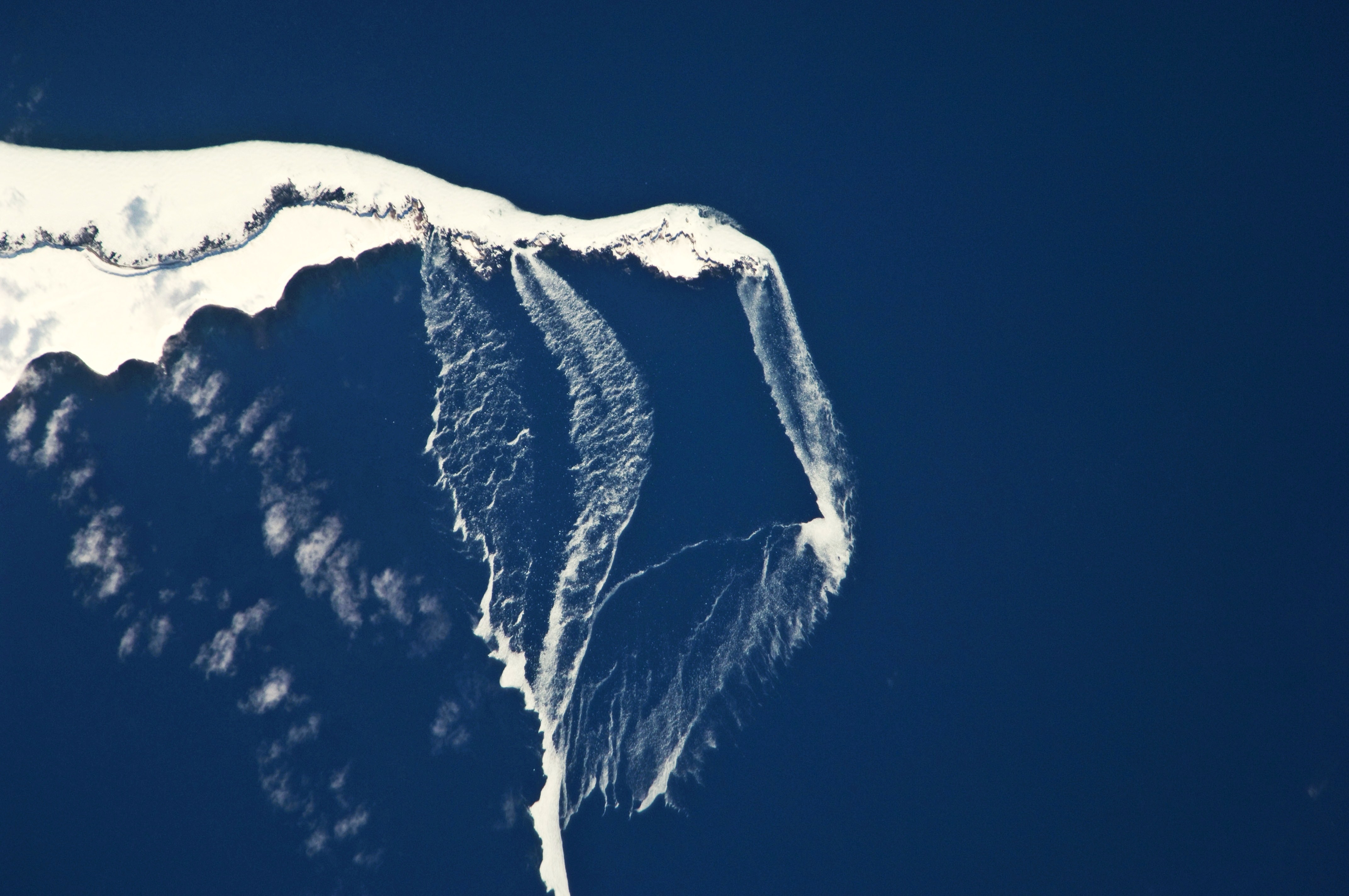
Urup ( ja, 得撫島, Uruppu-to; russian: Уру́п, Urúp, ain, ウルㇷ゚, Urup) is an uninhabited volcanic island in the Kuril Islands chain in the south of the Sea of Okhotsk, northwest Pacific Ocean. Its name is derived from the Ainu language word for salmon trout. It was formerly known as Company's Land. Geography and climate Urup has a roughly rectangular shape, measuring along its long axis and approximately along its narrow axis. It is the fourth largest of the Kuril Islands, with an area of . The highest point is Gora Ivao at . The strait between Urup and Iturup is known as the Vries Strait, after Dutch explorer Maarten Gerritsz Vries, the first recorded European to explore the area. The strait between Urup and Simushir is known as Bussol Strait, after the French word for "compass", which was the name of one of La Pérouse's vessels. This French mariner explored the area of the Kuril Islands in 1787. Urup consists of four major groups of active or dormant stra ... [...More Info...] [...Related Items...] OR: [Wikipedia] [Google] [Baidu] |
Bussol Strait
The Bussol Strait (Russian language, Russian: ''Proliv Bussol''), known in Japan as the , is a wide strait that separates the islands of Broutona and Chyornye Bratya, Chirpoy to the west from Simushir to the east. It is nearly 58 km (about 36 mi) wide, making it the largest channel in the Kuril Islands.National Geospatial-Intelligence Agency. (2014). ''Sailing Directions (Enroute): East Coast of Russia''. U.S. Government, Springfield, Virginia. It is named after the frigate ''French ship Boussole (1781), Boussole''. History The strait was a popular route in the 1840s for United States, American whaler, whaleships entering and exiting the Sea of Okhotsk on their way to and from cruises for North Pacific right whale, right whales. It was rarely used from the 1850s to the 1870s when ships primarily cruised to the north for bowhead whales, using the more convenient Fourth Kuril Strait further north instead. Among the few to use it during that period was the ship ''Susan'' (349 tons), o ... [...More Info...] [...Related Items...] OR: [Wikipedia] [Google] [Baidu] |
Kuril Islands
The Kuril Islands or Kurile Islands (; rus, Кури́льские острова́, r=Kuril'skiye ostrova, p=kʊˈrʲilʲskʲɪjə ɐstrɐˈva; Japanese: or ) are a volcanic archipelago currently administered as part of Sakhalin Oblast in the Russian Far East. It stretches approximately northeast from Hokkaido in Japan to Kamchatka Peninsula in Russia separating the Sea of Okhotsk from the north Pacific Ocean. There are 56 islands and many minor rocks. The Kuril Islands consist of the Greater Kuril Chain and the Lesser Kuril Chain. They cover an area of around , with a population of roughly 20,000. The islands have been under Russian administration since their 1945 invasion as the Soviet Union towards the end of World War II. Japan claims the four southernmost islands, including two of the three largest ( Iturup and Kunashir), as part of its territory, as well as Shikotan and the Habomai islets, which has led to the ongoing Kuril Islands dispute. The disputed islands are k ... [...More Info...] [...Related Items...] OR: [Wikipedia] [Google] [Baidu] |
NASA
The National Aeronautics and Space Administration (NASA ) is an independent agency of the US federal government responsible for the civil space program, aeronautics research, and space research. NASA was established in 1958, succeeding the National Advisory Committee for Aeronautics (NACA), to give the U.S. space development effort a distinctly civilian orientation, emphasizing peaceful applications in space science. NASA has since led most American space exploration, including Project Mercury, Project Gemini, the 1968-1972 Apollo Moon landing missions, the Skylab space station, and the Space Shuttle. NASA supports the International Space Station and oversees the development of the Orion spacecraft and the Space Launch System for the crewed lunar Artemis program, Commercial Crew spacecraft, and the planned Lunar Gateway space station. The agency is also responsible for the Launch Services Program, which provides oversight of launch operations and countdown management f ... [...More Info...] [...Related Items...] OR: [Wikipedia] [Google] [Baidu] |
Rudakov
Rudakov (russian: Рудаков) is a stratovolcano located in the central part of Urup Island, Kuril Islands, Russia. The volcano has a wide crater which contains a wide crater lake. See also * List of volcanoes in Russia This is a list of active and extinct volcanoes in Russia. European Russia Kamchatka Volcanoes of the Kamchatka Peninsula of the northwestern Pacific Ocean and the Russian Far East. Kuril Islands Volcanoes of the Kuril Islands, in the nor ... References * Urup Stratovolcanoes of Russia Volcanic crater lakes Holocene stratovolcanoes Holocene Asia Volcanoes of the Kuril Islands {{SakhalinOblast-geo-stub ... [...More Info...] [...Related Items...] OR: [Wikipedia] [Google] [Baidu] |
Autumn Equinox (Northern Hemisphere)
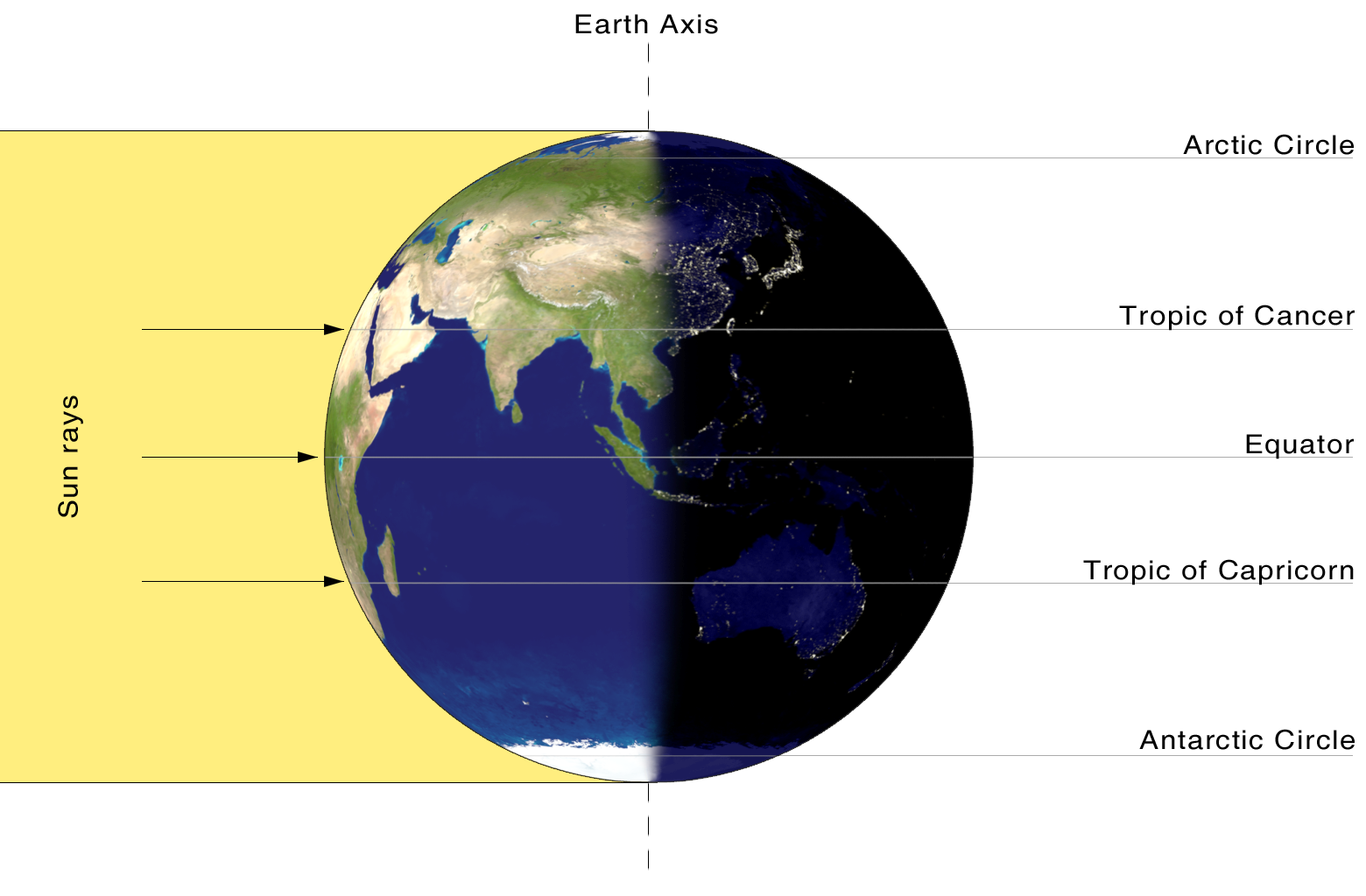
The September equinox (or southward equinox) is the moment when the Sun appears to cross the celestial equator, heading southward. Because of differences between the calendar year and the tropical year, the September equinox may occur anytime from September 21 to 24. At the equinox, the Sun as viewed from the equator rises due east and sets due west. Before the Southward equinox, the Sun rises and sets more northerly, and afterwards, it rises and sets more southerly. The equinox may be taken to mark the end of astronomical summer and the beginning of astronomical autumn (autumnal equinox) in the Northern Hemisphere, while marking the end of astronomical winter and the start of astronomical spring (vernal equinox) in the Southern Hemisphere. Occurrences The September equinox is one point in time commonly used to determine the length of the tropical year. The dates and times of the September equinoxes that occur from the year 2017 to 2027 (UTC) are listed as follows: C ... [...More Info...] [...Related Items...] OR: [Wikipedia] [Google] [Baidu] |
Seasonal Lag
Seasonal lag is the phenomenon whereby the date of maximum average air temperature at a geographical location on a planet is delayed until some time after the date of maximum insolation (i.e. the summer solstice). This also applies to the minimum temperature being delayed until some time after the date of minimum insolation. In most Northern Hemisphere regions, the month of February is usually colder than the month of November despite February having significantly later sunsets and more daylight overall. Conversely, the month of August is usually hotter than the month of May despite August having later sunrises, increasingly earlier sunsets, and less daylight overall. In all cases, the change in average air temperature lags behind the more consistent change in daylight patternsdelaying the perceived start of the next season for a month or so. An analogous temperature lag phenomenon occurs in diurnal temperature variation, where maximum daily temperature occurs after noon (maximu ... [...More Info...] [...Related Items...] OR: [Wikipedia] [Google] [Baidu] |
Manchuria
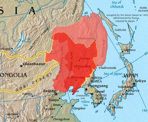
Manchuria is an exonym (derived from the endo demonym " Manchu") for a historical and geographic region in Northeast Asia encompassing the entirety of present-day Northeast China (Inner Manchuria) and parts of the Russian Far East (Outer Manchuria). Its meaning may vary depending on the context: * Historical polities and geographical regions usually referred to as Manchuria: ** The Later Jin (1616–1636), the Manchu-led dynasty which renamed itself from "Jin" to "Qing", and the ethnicity from "Jurchen" to "Manchu" in 1636 ** the subsequent duration of the Qing dynasty prior to its conquest of China proper (1644) ** the northeastern region of Qing dynasty China, the homeland of Manchus, known as "Guandong" or "Guanwai" during the Qing dynasty ** The region of Northeast Asia that served as the historical homeland of the Jurchens and later their descendants Manchus ***Qing control of Dauria (the region north of the Amur River, but in its watershed) was contested in 1643 when ... [...More Info...] [...Related Items...] OR: [Wikipedia] [Google] [Baidu] |
Siberia
Siberia ( ; rus, Сибирь, r=Sibir', p=sʲɪˈbʲirʲ, a=Ru-Сибирь.ogg) is an extensive geographical region, constituting all of North Asia, from the Ural Mountains in the west to the Pacific Ocean in the east. It has been a part of Russia since the latter half of the 16th century, after the Russians conquered lands east of the Ural Mountains. Siberia is vast and sparsely populated, covering an area of over , but home to merely one-fifth of Russia's population. Novosibirsk, Krasnoyarsk and Omsk are the largest cities in the region. Because Siberia is a geographic and historic region and not a political entity, there is no single precise definition of its territorial borders. Traditionally, Siberia extends eastwards from the Ural Mountains to the Pacific Ocean, and includes most of the drainage basin of the Arctic Ocean. The river Yenisey divides Siberia into two parts, Western and Eastern. Siberia stretches southwards from the Arctic Ocean to the hills of north-ce ... [...More Info...] [...Related Items...] OR: [Wikipedia] [Google] [Baidu] |
Aleutian Islands
The Aleutian Islands (; ; ale, Unangam Tanangin,”Land of the Aleuts", possibly from Chukchi language, Chukchi ''aliat'', "island"), also called the Aleut Islands or Aleutic Islands and known before 1867 as the Catherine Archipelago, are a chain of 14 large volcanic islands and 55 smaller islands. Most of the Aleutian Islands belong to the U.S. state of Alaska, but some belong to the Russian Federal subjects of Russia, federal subject of Kamchatka Krai. They form part of the Aleutian Arc in the Northern Pacific Ocean, occupying a land area of 6,821 sq mi (17,666 km2) and extending about westward from the Alaska Peninsula toward the Kamchatka Peninsula in Russia, and act as a border between the Bering Sea to the north and the Pacific Ocean to the south. Crossing 180th meridian, longitude 180°, at which point east and west longitude end, the archipelago contains both the westernmost part of the United States by longitude (Amatignak Island) and the easternmost by longitude ( ... [...More Info...] [...Related Items...] OR: [Wikipedia] [Google] [Baidu] |
Subpolar Oceanic Climate
An oceanic climate, also known as a marine climate, is the humid temperate climate sub-type in Köppen classification ''Cfb'', typical of west coasts in higher middle latitudes of continents, generally featuring cool summers and mild winters (for their latitude), with a relatively narrow annual temperature range and few extremes of temperature. Oceanic climates can be found in both hemispheres generally between 45 and 63 latitude, most notably in northwestern Europe, northwestern America, as well as New Zealand. Precipitation Locations with oceanic climates tend to feature frequent cloudy conditions with precipitation, low hanging clouds, and frequent fronts and storms. Thunderstorms are normally few, since strong daytime heating and hot and cold air masses meet infrequently in the region. In most areas with an oceanic climate, precipitation comes in the form of rain for the majority of the year. However, some areas with this climate see some snowfall annually during winter. M ... [...More Info...] [...Related Items...] OR: [Wikipedia] [Google] [Baidu] |
Köppen Climate Classification
The Köppen climate classification is one of the most widely used climate classification systems. It was first published by German-Russian climatologist Wladimir Köppen (1846–1940) in 1884, with several later modifications by Köppen, notably in 1918 and 1936. Later, the climatologist Rudolf Geiger (1894–1981) introduced some changes to the classification system, which is thus sometimes called the Köppen–Geiger climate classification system. The Köppen climate classification divides climates into five main climate groups, with each group being divided based on seasonal precipitation and temperature patterns. The five main groups are ''A'' (tropical), ''B'' (arid), ''C'' (temperate), ''D'' (continental), and ''E'' (polar). Each group and subgroup is represented by a letter. All climates are assigned a main group (the first letter). All climates except for those in the ''E'' group are assigned a seasonal precipitation subgroup (the second letter). For example, ''Af'' indi ... [...More Info...] [...Related Items...] OR: [Wikipedia] [Google] [Baidu] |
Subarctic Climate
The subarctic climate (also called subpolar climate, or boreal climate) is a climate with long, cold (often very cold) winters, and short, warm to cool summers. It is found on large landmasses, often away from the moderating effects of an ocean, generally at latitudes from 50° to 70°N, poleward of the humid continental climates. Subarctic or boreal climates are the source regions for the cold air that affects temperate latitudes to the south in winter. These climates represent Köppen climate classification ''Dfc'', ''Dwc'', ''Dsc'', ''Dfd'', ''Dwd'' and ''Dsd''. Description This type of climate offers some of the most extreme seasonal temperature variations found on the planet: in winter, temperatures can drop to below and in summer, the temperature may exceed . However, the summers are short; no more than three months of the year (but at least one month) must have a 24-hour average temperature of at least to fall into this category of climate, and the coldest month should ave ... [...More Info...] [...Related Items...] OR: [Wikipedia] [Google] [Baidu] |


.png)


