|
Sisira Well
The Sisera well is one of the ancient wells in the Al-Jawf region in Saudi Arabia. Location The Sisera well is located north of Sakaka, near the castle of Zaabal. Etymology The name of the well belongs to the Canaanite military commander Sisera who fought the Jews in Palestine, and he was the commander of the Canaanite army. His name was mentioned in the biblical and Christian texts as he is an enemy of the Jews. Description The Sisra Well is a well dug in a sandy rock, and it takes the oval shape with diameters of length 8m x 7m, with a depth of about 15m. It was carved on its inner sides stairs to its bottom. There is a channel engraved in the rock inside the well that was used to transport water to farms. This type of irrigation system was known during the Nabataean period (1st century AD). The site was restored, the well was surrounded with stems for protection, and the surrounding area was paved with stones. There is a paved road that connects to the site. In addi ... [...More Info...] [...Related Items...] OR: [Wikipedia] [Google] [Baidu] |
Al Jawf Region
Al-Jawf Province ( ar, منطقة الجوف Minṭaqat al-Jawf pronounced lˈdʒoːf, also spelled Al-Jouf, is one of the provinces of Saudi Arabia, located in the north of the country, containing its only international border with Jordan to the west. It is one of the earliest inhabited regions of Arabian Peninsula, with evidence of human habitation dating back to the Stone Age and the Acheulean tool culture. Human settlement continued unbroken throughout the Copper Age, a period that saw the kingdom of Qidar fight against the Assyrian state for its independence. It is also in this period that references to Arabs first appear in historical texts. A Christian kingdom later emerged under the rule of the Bani Kalb tribe and survived until the arrival of Islam and the Islamic conquest of Al-Jawf. Following the region's Islamization it fell under the control of the Tayy tribe. Al-Jawf was incorporated into the third Saudi state at the time of its formation in 1932. In the ... [...More Info...] [...Related Items...] OR: [Wikipedia] [Google] [Baidu] |
Saudi Arabia
Saudi Arabia, officially the Kingdom of Saudi Arabia (KSA), is a country in Western Asia. It covers the bulk of the Arabian Peninsula, and has a land area of about , making it the fifth-largest country in Asia, the second-largest in the Arab world, and the largest in Western Asia and the Middle East. It is bordered by the Red Sea to the west; Jordan, Iraq, and Kuwait to the north; the Persian Gulf, Qatar and the United Arab Emirates to the east; Oman to the southeast; and Yemen to the south. Bahrain is an island country off the east coast. The Gulf of Aqaba in the northwest separates Saudi Arabia from Egypt. Saudi Arabia is the only country with a coastline along both the Red Sea and the Persian Gulf, and most of its terrain consists of arid desert, lowland, steppe, and mountains. Its capital and largest city is Riyadh. The country is home to Mecca and Medina, the two holiest cities in Islam. Pre-Islamic Arabia, the territory that constitutes modern-day Saudi Ar ... [...More Info...] [...Related Items...] OR: [Wikipedia] [Google] [Baidu] |
Sisra Well
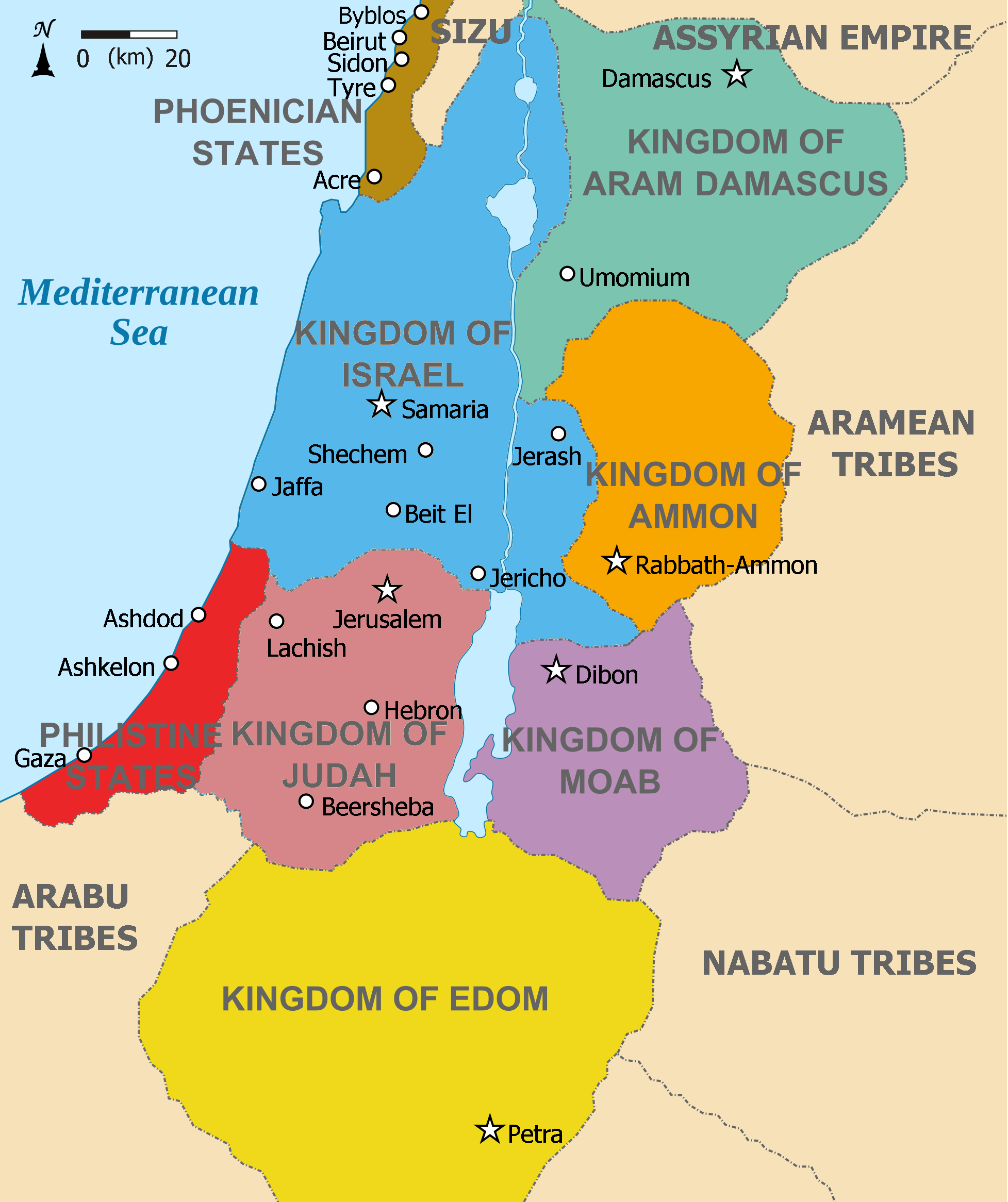
Sisera ( he, סִיסְרָא ''Sîsərā'') was commander of the Canaanite army of King Jabin of Hazor, who is mentioned in of the Hebrew Bible. After being defeated by the forces of the Israelite tribes of Zebulun and Naphtali under the command of Barak and Deborah, Sisera was killed by Jael, who hammered a tent peg into his temple. Biblical account According to the biblical book of Judges, Jabin, King of Hazor, oppressed the Israelites for twenty years. His general was Sisera, who commanded nine hundred iron chariots from Harosheth Haggoyim, a fortified cavalry base. After the prophetess Deborah persuaded Barak to face Sisera in battle, they, with an Israelite force of ten thousand, defeated him at the Battle of Mount Tabor on the plain of Esdraelon. Judges 5:20 says that "the stars in their courses fought against Sisera", and the following verse implies that the army was swept away by the Wadi Kishon. Following the battle, there was peace for forty years. After the b ... [...More Info...] [...Related Items...] OR: [Wikipedia] [Google] [Baidu] |
Canaan
Canaan (; Phoenician: 𐤊𐤍𐤏𐤍 – ; he, כְּנַעַן – , in pausa – ; grc-bib, Χανααν – ;The current scholarly edition of the Greek Old Testament spells the word without any accents, cf. Septuaginta : id est Vetus Testamentum graece iuxta LXX interpretes. 2. ed. / recogn. et emendavit Robert Hanhart. Stuttgart : Dt. Bibelges., 2006 . However, in modern Greek the accentuation is , while the current (28th) scholarly edition of the New Testament has . ar, كَنْعَانُ – ) was a Semitic-speaking civilization and region in the Ancient Near East during the late 2nd millennium BC. Canaan had significant geopolitical importance in the Late Bronze Age Amarna Period (14th century BC) as the area where the spheres of interest of the Egyptian, Hittite, Mitanni and Assyrian Empires converged or overlapped. Much of present-day knowledge about Canaan stems from archaeological excavation in this area at sites such as Tel Hazor, Tel Megiddo, En Esur ... [...More Info...] [...Related Items...] OR: [Wikipedia] [Google] [Baidu] |
Sisera
Sisera ( he, סִיסְרָא ''Sîsərā'') was commander of the Canaanite army of King Jabin of Hazor, who is mentioned in of the Hebrew Bible. After being defeated by the forces of the Israelite tribes of Zebulun and Naphtali under the command of Barak and Deborah, Sisera was killed by Jael, who hammered a tent peg into his temple. Biblical account According to the biblical book of Judges, Jabin, King of Hazor, oppressed the Israelites for twenty years. His general was Sisera, who commanded nine hundred iron chariots from Harosheth Haggoyim, a fortified cavalry base. After the prophetess Deborah persuaded Barak to face Sisera in battle, they, with an Israelite force of ten thousand, defeated him at the Battle of Mount Tabor on the plain of Esdraelon. Judges 5:20 says that "the stars in their courses fought against Sisera", and the following verse implies that the army was swept away by the Wadi Kishon. Following the battle, there was peace for forty years. After the battl ... [...More Info...] [...Related Items...] OR: [Wikipedia] [Google] [Baidu] |
Palestine (region)
Palestine ( el, Παλαιστίνη, ; la, Palaestina; ar, فلسطين, , , ; he, פלשתינה, ) is a geographic region in Western Asia. It is usually considered to include Israel and the State of Palestine (i.e. West Bank and Gaza Strip), though some definitions also include part of northwestern Jordan. The first written records to attest the name of the region were those of the Twentieth dynasty of Egypt, which used the term "Peleset" in reference to the neighboring people or land. In the 8th century, Assyrian inscriptions refer to the region of "Palashtu" or "Pilistu". In the Hellenistic period, these names were carried over into Greek, appearing in the Histories of Herodotus in the more recognizable form of "Palaistine". The Roman Empire initially used other terms for the region, such as Judaea, but renamed the region Syria Palaestina after the Bar Kokhba revolt. During the Byzantine period, the region was split into the provinces of Palaestina Prima, Palaestin ... [...More Info...] [...Related Items...] OR: [Wikipedia] [Google] [Baidu] |
Nabataeans
The Nabataeans or Nabateans (; Nabataean Aramaic: , , vocalized as ; Arabic language, Arabic: , , singular , ; compare grc, Ναβαταῖος, translit=Nabataîos; la, Nabataeus) were an ancient Arab people who inhabited northern Arabian Peninsula, Arabia and the southern Levant. Their settlements—most prominently the assumed capital city of Petra, Raqmu (present-day Petra, Jordan)—gave the name ''Nabatene'' ( grc, Ναβατηνή, translit=Nabatēnḗ) to the Arabian borderland that stretched from the Euphrates to the Red Sea. The Nabateans emerged as a distinct civilization and political entity between the 4th and 2nd centuries BCE,Taylor, Jane (2001). ''Petra and the Lost Kingdom of the Nabataeans''. London: I.B.Tauris. pp. 14, 17, 30, 31. . Retrieved 8 July 2016. with Nabataean Kingdom, their kingdom centered around a loosely controlled trading network that brought considerable wealth and influence across the ancient world. Described as fiercely independent by cont ... [...More Info...] [...Related Items...] OR: [Wikipedia] [Google] [Baidu] |
Sakakah
Sakākā () is a city in northwestern Saudi Arabia which is the capital of Al Jawf Province. It is located just to the north of the An Nafud desert. Sakakah had a population of 242,813 at the 2010 census. History Sakakah is an oasis town on an ancient caravan route across the Arabian peninsula. Modernization In recent years, the Saudi government has been providing more seed capital to Al-Jawf region, especially in Sakaka in hopes of developing the economically starved region of the kingdom. For this reason, the city has new government buildings, schools and hospitals and are built adjacent to crumbling ruins of older buildings. One major feature of the city is the rapidly expanding Al Jouf University (Jami'at Al-Jawf), founded in 2005. Sakaka is a small but expanding city with much construction in progress. A big ongoing project is the 1,000-bed Prince Muhammed Bin Abdulaziz Medical City which is under construction. Education The King hopes that Al Jouf University will become a ... [...More Info...] [...Related Items...] OR: [Wikipedia] [Google] [Baidu] |
Columns Of Rajajil
The Rajajel Columns is an archaeological site of pillars carved from sandstone thought to be 6,000 years old. It is located in the Al Jawf Region in Saudi Arabia. Specifically situated in the suburb of Qara south of Sakakah, it consists of 50 groups of erected stone columns called Rajajil. Some of the existing columns are higher than three meters, while they are about 60 cm thick. Etymology It is called "Rajajil" which means men because it looks like a man if it is seen from a distance. Historical background The Rajajil columns may belong to a temple built in the fourth millennium BC. The site contains about 50 groups of erect stone pillars and several broken columns lying on the ground. These groups are distributed in a large circle overlooking a wide sandy plain. Each group includes two to ten columns, one of which is approximately three meters high. Archaeologists believe that the site dates back to the fourth millennium BC. These columns are very similar to Stone ... [...More Info...] [...Related Items...] OR: [Wikipedia] [Google] [Baidu] |


