|
Arrondissements Of The Nord Department (France)
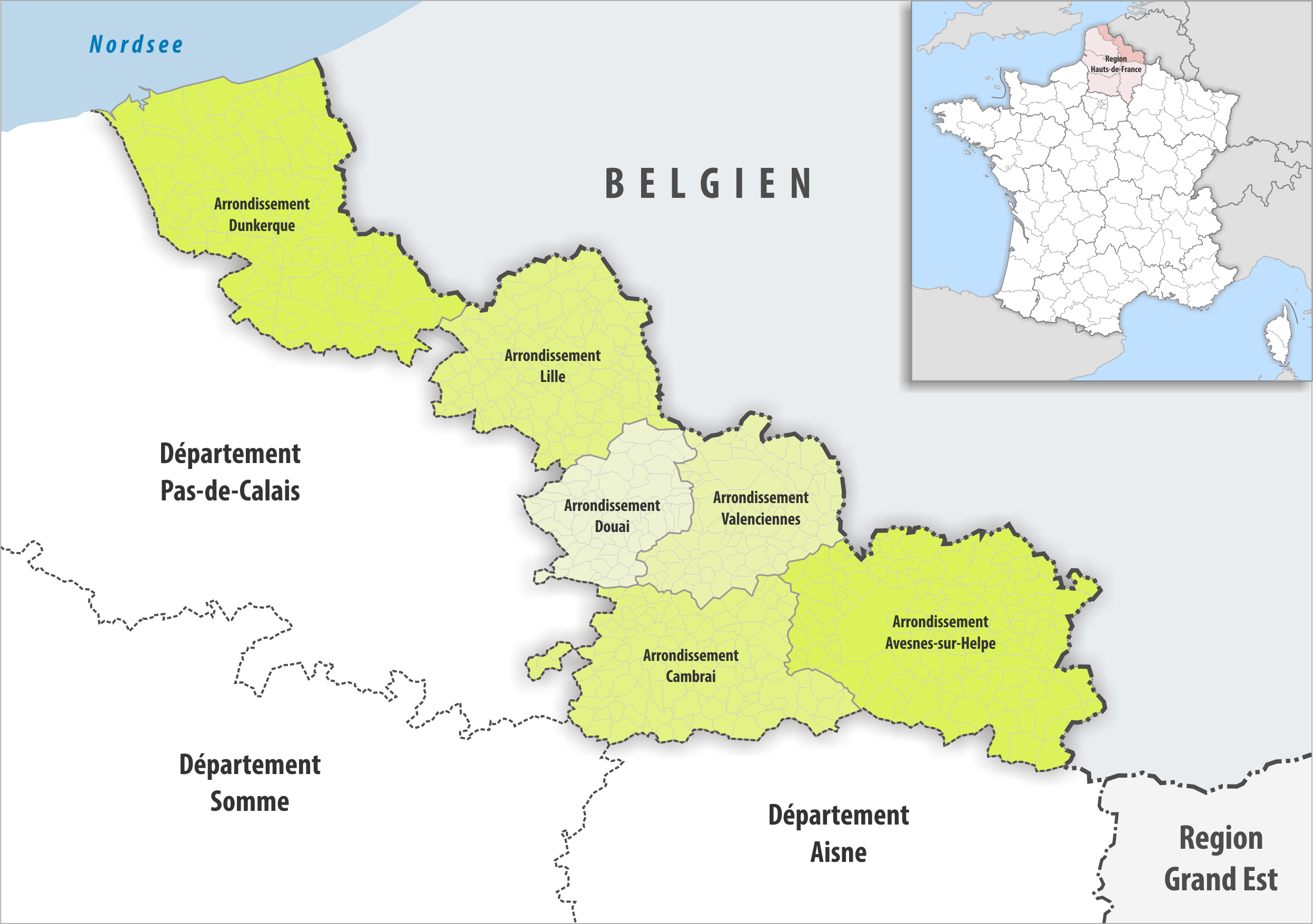
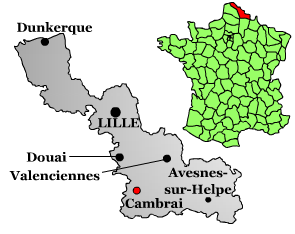
The 6 arrondissements of the Nord department are: # Arrondissement of Avesnes-sur-Helpe, (subprefecture: Avesnes-sur-Helpe) with 151 communes. Its population was 230,372 in 2016. # Arrondissement of Cambrai, (subprefecture: Cambrai) with 116 communes. Its population was 162,045 in 2016. # Arrondissement of Douai, (subprefecture: Douai) with 64 communes. Its population was 245,280 in 2016. # Arrondissement of Dunkirk (''Dunkerque''), (subprefecture: Dunkirk) with 111 communes. Its population was 377,294 in 2016. # Arrondissement of Lille, (prefecture of the Nord department: Lille) with 124 communes. Its population was 1,237,472 in 2016. # Arrondissement of Valenciennes, (subprefecture: Valenciennes) with 82 communes. Its population was 351,260 in 2016. History In 1800 the arrondissements of Douai, Avesnes, Bergues, Cambrai, Cassel and Lille were established. In 1803 Dunkirk replaced Bergues as subprefecture. Lille replaced Douai as prefecture in 1804. In 1824 the arrondiss ... [...More Info...] [...Related Items...] OR: [Wikipedia] [Google] [Baidu] |
Département Nord Arrondissement 2016
In the administrative divisions of France, the department (french: département, ) is one of the three levels of government under the national level ("territorial collectivities"), between the administrative regions and the communes. Ninety-six departments are in metropolitan France, and five are overseas departments, which are also classified as overseas regions. Departments are further subdivided into 332 arrondissements, and these are divided into cantons. The last two levels of government have no autonomy; they are the basis of local organisation of police, fire departments and, sometimes, administration of elections. Each department is administered by an elected body called a departmental council ( ing. lur.. From 1800 to April 2015, these were called general councils ( ing. lur.. Each council has a president. Their main areas of responsibility include the management of a number of social and welfare allowances, of junior high school () buildings and technical staff, ... [...More Info...] [...Related Items...] OR: [Wikipedia] [Google] [Baidu] |
Arrondissement Of Douai
The arrondissement of Douai ( vls, Dowaai) is an arrondissement of France in the Nord department in the Hauts-de-France region. It has 64 communes. Its population is 245,280 (2016), and its area is . Composition The communes of the arrondissement of Douai, and their INSEE codes, are: # Aix-en-Pévèle (59004) # Anhiers (59007) # Aniche (59008) # Arleux (59015) # Auberchicourt (59024) # Aubigny-au-Bac (59026) # Auby (59028) # Auchy-lez-Orchies (59029) # Beuvry-la-Forêt (59080) # Bouvignies (59105) # Bruille-lez-Marchiennes (59113) # Brunémont (59115) # Bugnicourt (59117) # Cantin (59126) # Courchelettes (59156) # Coutiches (59158) # Cuincy (59165) # Dechy (59170) # Douai (59178) # Écaillon (59185) # Erchin (59199) # Erre (59203) # Esquerchin (59211) # Estrées (59214) # Faumont (59222) # Féchain (59224) # Fenain (59227) # Férin (59228) # Flers-en-Escrebieux (59234) # Flines-lez-Raches (59239) # Fressain (59254) # Gœulzin (59263) # Guesnain (59276) # Hamel (5928 ... [...More Info...] [...Related Items...] OR: [Wikipedia] [Google] [Baidu] |
Valenciennes
Valenciennes (, also , , ; nl, label=also Dutch, Valencijn; pcd, Valincyinnes or ; la, Valentianae) is a commune in the Nord department, Hauts-de-France, France. It lies on the Scheldt () river. Although the city and region experienced a steady population decline between 1975 and 1990, it has since rebounded. The 1999 census recorded that the population of the commune of Valenciennes was 41,278, and that of the metropolitan area was 399,677. History Before 1500 Valenciennes is first mentioned in 693 in a legal document written by Clovis II (''Valentiana''). In the 843 Treaty of Verdun, it was made a neutral city between Neustria and the Austrasia. Later in the 9th century the region was overrun by the Normans, and in 881 the town passed to them. In 923 it passed to the Duchy of Lower Lotharingia dependent on the Holy Roman Empire. Once the Empire of the Franks was established, the city began to develop, though the archaeological record has still not revealed all it has to ... [...More Info...] [...Related Items...] OR: [Wikipedia] [Google] [Baidu] |
Arrondissement Of Valenciennes
The arrondissement of Valenciennes is an arrondissement of France in the Nord department in the Hauts-de-France region. It has 82 communes. Its population is 351,260 (2016), and its area is . Composition The communes of the arrondissement of Valenciennes, and their INSEE codes, are: # Abscon (59002) # Anzin (59014) # Artres (59019) # Aubry-du-Hainaut (59027) # Aulnoy-lez-Valenciennes (59032) # Avesnes-le-Sec (59038) # Bellaing (59064) # Beuvrages (59079) # Bouchain (59092) # Bousignies (59100) # Brillon (59109) # Bruay-sur-l'Escaut (59112) # Bruille-Saint-Amand (59114) # Château-l'Abbaye (59144) # Condé-sur-l'Escaut (59153) # Crespin (59160) # Curgies (59166) # Denain (59172) # Douchy-les-Mines (59179) # Émerchicourt (59192) # Escaudain (59205) # Escautpont (59207) # Estreux (59215) # Famars (59221) # Flines-lès-Mortagne (59238) # Fresnes-sur-Escaut (59253) # Hasnon (59284) # Haspres (59285) # Haulchin (59288) # Haveluy (59292) # Hélesmes (59297) # Hergnies (59301) ... [...More Info...] [...Related Items...] OR: [Wikipedia] [Google] [Baidu] |
Lille
Lille ( , ; nl, Rijsel ; pcd, Lile; vls, Rysel) is a city in the northern part of France, in French Flanders. On the river Deûle, near France's border with Belgium, it is the capital of the Hauts-de-France Regions of France, region, the Prefectures in France, prefecture of the Nord (French department), Nord Departments of France, department, and the main city of the Métropole Européenne de Lille, European Metropolis of Lille. The city of Lille proper had a population of 234,475 in 2019 within its small municipal territory of , but together with its French suburbs and exurbs the Lille metropolitan area (French part only), which extends over , had a population of 1,510,079 that same year (Jan. 2019 census), the fourth most populated in France after Paris, Lyon, and Marseille. The city of Lille and 94 suburban French municipalities have formed since 2015 the Métropole Européenne de Lille, European Metropolis of Lille, an Indirect election, indirectly elected Métropole, metr ... [...More Info...] [...Related Items...] OR: [Wikipedia] [Google] [Baidu] |
Prefectures In France
In France, a prefecture (french: préfecture) may be: * the ''chef-lieu de département'', the commune in which the administration of a department is located; * the ''chef-lieu de région'', the commune in which the administration of a region is located; * the jurisdiction of a prefecture; * the official residence or headquarters of a prefect. Although the administration of departments and regions is distinct, a regional prefect is '' ex officio'' prefect of the department in which the regional prefecture is located. The officeholder has authority upon the other prefects in the region on a range of matters. Role of the prefecture There are 101 prefectures in France, one for each department. The official in charge is the prefect (french: préfet). The prefecture is an administration that belongs to the Ministry of the Interior; it is therefore in charge of the delivery of identity cards, driving licenses, passports, residency and work permits for foreigners, vehicle registration, ... [...More Info...] [...Related Items...] OR: [Wikipedia] [Google] [Baidu] |
Arrondissement Of Lille
The arrondissement of Lille is an arrondissement of France in the Nord department in the Hauts-de-France region. It has 124 communes. Its population is 1,237,472 (2016), and its area is . Composition The communes of the arrondissement of Lille, and their INSEE codes, are: # Allennes-les-Marais (59005) # Annœullin (59011) # Anstaing (59013) # Armentières (59017) # Attiches (59022) # Aubers (59025) # Avelin (59034) # Bachy (59042) # Baisieux (59044) # La Bassée (59051) # Bauvin (59052) # Beaucamps-Ligny (59056) # Bersée (59071) # Bois-Grenier (59088) # Bondues (59090) # Bourghelles (59096) # Bousbecque (59098) # Bouvines (59106) # Camphin-en-Carembault (59123) # Camphin-en-Pévèle (59124) # Capinghem (59128) # Cappelle-en-Pévèle (59129) # Carnin (59133) # La Chapelle-d'Armentières (59143) # Chemy (59145) # Chéreng (59146) # Cobrieux (59150) # Comines (59152) # Croix (59163) # Cysoing (59168) # Deûlémont (59173) # Don (59670) # Emmerin (59193) # Engl ... [...More Info...] [...Related Items...] OR: [Wikipedia] [Google] [Baidu] |
Dunkirk
Dunkirk (french: Dunkerque ; vls, label=French Flemish, Duunkerke; nl, Duinkerke(n) ; , ;) is a commune in the department of Nord in northern France.Commune de Dunkerque (59183) INSEE It lies from the border. It has the third-largest French harbour. The population of the commune in 2019 was 86,279. Etymology and language use The name of Dunkirk derives from '' or ' |
Arrondissement Of Dunkirk
The arrondissement of Dunkirk (french: Dunkerque, nl, Duinkerke) is an arrondissement of France in the Nord department in the Hauts-de-France region. It has 111 communes. Its population is 377,294 (2016), and its area is . It roughly corresponds to the French Westhoek (part of French Flanders), where traditionally French Flemish is spoken. Composition The communes of the arrondissement of Dunkirk, and their INSEE codes, are: # Armbouts-Cappel (59016) # Arnèke (59018) # Bailleul (59043) # Bambecque (59046) # Bavinchove (59054) # Bergues (59067) # Berthen (59073) # Bierne (59082) # Bissezeele (59083) # Blaringhem (59084) # Boeschepe (59086) # Boëseghem (59087) # Bollezeele (59089) # Borre (59091) # Bourbourg (59094) # Bray-Dunes (59107) # Brouckerque (59110) # Broxeele (59111) # Buysscheure (59119) # Caëstre (59120) # Cappelle-Brouck (59130) # Cappelle-la-Grande (59131) # Cassel (59135) # Coudekerque-Branche (59155) # Craywick (59159) # Crochte (59162) # Le Do ... [...More Info...] [...Related Items...] OR: [Wikipedia] [Google] [Baidu] |
Douai
Douai (, , ,; pcd, Doï; nl, Dowaai; formerly spelled Douay or Doway in English) is a city in the Nord département in northern France. It is a sub-prefecture of the department. Located on the river Scarpe some from Lille and from Arras, Douai is home to one of the region's most impressive belfries. History Its site probably corresponds to that of a 4th-century Roman fortress known as Duacum. From the 10th century, the town was a romance fiefdom of the counts of Flanders. The town became a flourishing textile market centre during the Middle Ages, historically known as Douay or Doway in English. In 1384, the county of Flanders passed into the domains of the Dukes of Burgundy and thence in 1477 into Habsburg possessions. In 1667, Douai was taken by the troops of Louis XIV of France, and by the 1668 Treaty of Aix-la-Chapelle, the town was ceded to France. During successive sieges from 1710 to 1712, Douai was almost completely destroyed by the British Army. By 1713, the town ... [...More Info...] [...Related Items...] OR: [Wikipedia] [Google] [Baidu] |
Cambrai
Cambrai (, ; pcd, Kimbré; nl, Kamerijk), formerly Cambray and historically in English Camerick or Camericke, is a city in the Nord (French department), Nord Departments of France, department and in the Hauts-de-France Regions of France, region of France on the Scheldt river, which is known locally as the Escaut river. A Subprefectures in France, sub-prefecture of the department, Cambrai is a town which had 32,501 inhabitants in 2018. It is in the heart of the urban unit of Cambrai with 46,772 inhabitants. Its functional area (France), functional area, a more extensive range, included 94,576 inhabitants in 2018.Comparateur de territoire: Aire d'attraction des villes 2020 de Cambra ... [...More Info...] [...Related Items...] OR: [Wikipedia] [Google] [Baidu] |
Arrondissements Of France
An arrondissement (, , ) is any of various administrative divisions of France, Belgium, Haiti, certain other Francophone countries, as well as the Netherlands. Europe France The 101 French departments are divided into 342 ''arrondissements'', which may be roughly translated into English as districts. The capital of an arrondissement is called a subprefecture. When an arrondissement contains the prefecture (capital) of the department, that prefecture is the capital of the arrondissement, acting both as a prefecture and as a subprefecture. Arrondissements are further divided into cantons and communes. Municipal arrondissement A municipal arrondissement (, pronounced ), is a subdivision of the commune, used in the three largest cities: Paris, Lyon, and Marseille. It functions as an even lower administrative division, with its own mayor. Although usually referred to simply as an "arrondissement," they should not be confused with departmental arrondissements, which are groupin ... [...More Info...] [...Related Items...] OR: [Wikipedia] [Google] [Baidu] |

.jpg)

