|
Hășmaș Mountains
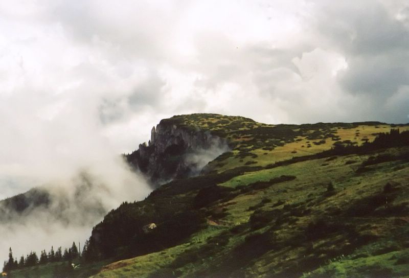
The Hășmaș Mountains ( Romanian: ''Munții Hășmaș''; Hungarian: ''Hagymás-hegység'') are limestone and sandstone massifs located in Romania, in the Inner Eastern Carpathians group of the Eastern Carpathian Mountains The Carpathian Mountains or Carpathians () are a range of mountains forming an arc across Central Europe and Southeast Europe. Roughly long, it is the third-longest European mountain range after the Ural Mountains, Urals at and the Scandinav .... They belong to the Bistrița Mountains range, and are bordered by the Giurgeu Mountains to the north, the Tarcău Mountains to the east, the Ciuc Mountains to the south, and the Harghita Mountains to the west. The Hășmaș Mountains include many cliffs and gorges, such as the Bicaz Gorge and the Panaghia Cliff. The highest peak is , at . The mountains contain the Cheile Bicazului-Hășmaș natural reserve. There is a lake known as the Lacul Roșu ("Red Lake"), named after the red clay that lay th ... [...More Info...] [...Related Items...] OR: [Wikipedia] [Google] [Baidu] |
Bistrița Mountains
The Bistrița Mountains (; ) are mountain ranges in northern central Romania. Geologically these ranges are considered part of the Inner Eastern Carpathians group of the Eastern Carpathians. Within Romania, however, it is traditional to divide the Eastern Carpathians in Romanian territory into three geographical groups (north, center, south), instead in Outer and Inner Eastern Carpathians. The Romanian categorization is indicated below. The Bistrița mountain range consist of the following mountains. * Bistrița Mountains (''Munții Bistriței'') per se, comprising ** Pietrosul Massif (''Masivul Pietrosul''; literally: ''Rocky Massif'') ** Budacul Massif (''Masivul Budacul'') ** Ceahlău Massif (''Masivul Ceahlău'') :with the latter sometimes considered a distinct range. In Romania these are considered part of the central Carpathians of Moldavia and Transylvania (''Munții Carpați Moldo-Transilvani''), or "MMT" * Mestecăniș Ridge (''Obcina Mestecăniș''). In Romania ... [...More Info...] [...Related Items...] OR: [Wikipedia] [Google] [Baidu] |
Red Lake (Romania)
Red Lake is a natural dam lake in Harghita County, Romania. It is located in the Hășmaș Mountains, on the upper course of the Bicaz River, and lies at the foot of the , near the Bicaz Gorge, at a distance of from Gheorgheni and from Bicaz. The lake formed following the collapse of a slope due to the earthquake of January 23, 1838 at 18:45, measuring 6.9 magnitude on the Richter scale, VIII intensity. The landslide blocked the course of the Bicaz River and the lake formed behind this dam. According to measurements in 1987, the lake has a perimeter of , and covers an area of ;Gheorghe Romanescu, Cristian Constantin Stoleriu and Andrei Enea the volume of water that accumulates is . The lake was formed at an altitude of , in a depression with a predominant subalpine climate. Location The Red Lake is located between Suhardul Mic and Suhardul Mare peaks on the north side, the Podu Calului Mountains to the south-west, the Licaș and Chișhovoș Mountains to the north-we ... [...More Info...] [...Related Items...] OR: [Wikipedia] [Google] [Baidu] |
Cheile Bicazului-Hășmaș National Park
The Cheile Bicazului - Hășmaș ('' Bicaz Gorges - Hășmaș Mountains'') National Park is located in north-eastern Romania, in the Eastern Carpathians mountain chain. The reservation territory is part of Neamț and Harghita counties. The park administration is located in Izvoru Mureșului, in Harghita County. Geologic features The park's most important geologic features are:Gheorghe Romanescu, Cristian Constantin Stoleriu and Andrei Enea * Cheile Bicazului (Bicaz Gorges), a deep canyon dug by the river Bicaz * Lacu Roșu (the Red Lake) – a natural dam lake *Hășmaș Mountains Most of the park's territory coincides with the syncline of the ''Hășmaș Massif'', over whose crystalline base lies a stack of sediments from the Mesozoic. In the Paleozoic, orogeny and tectonic shifts processes pushed older rocks formed in the Proterozoic over more recent rocks formed in the Cambrian.The end of the Paleozoic brings with it the formation of a geosyncline, which in the Triass ... [...More Info...] [...Related Items...] OR: [Wikipedia] [Google] [Baidu] |
Panaghia Cliff
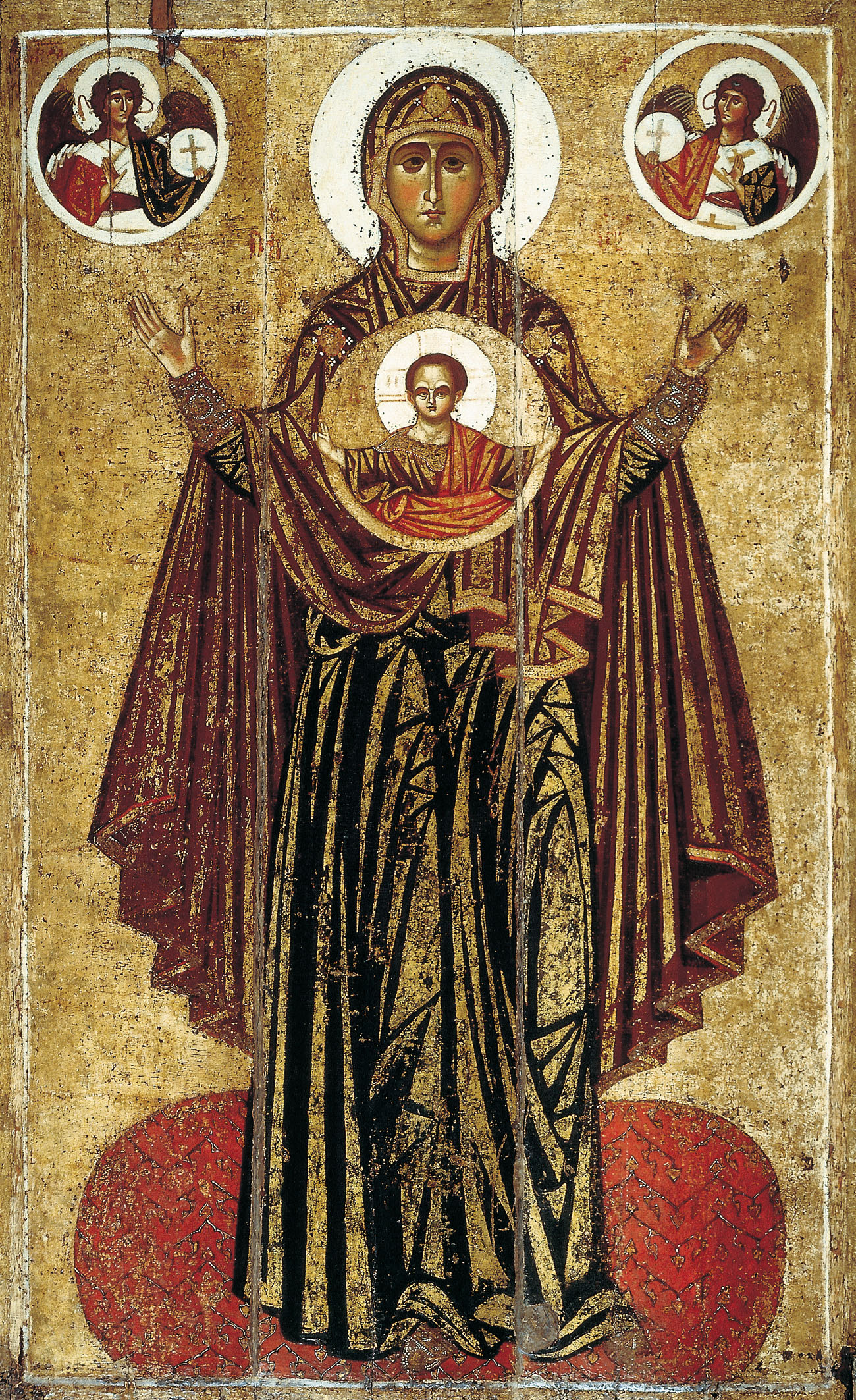
Panagia (, fem. of , + , the ''All-Holy'', or the ''Most Holy''; pronounced ) (also transliterated Panaghia or Panayia), in Medieval and Modern Greek, is one of the titles of Mary, Mother of God, used especially in Orthodox Christianity and Eastern Catholicism. Most Greek churches dedicated to the Virgin Mary are called ''Panagia''; the standard western Christian designation of "St. Mary" is rarely used in the East, as Mary is considered the holiest of all created beings and therefore of the highest status and glory of all the saints. Iconography ''Panagia'' is also the term for a particular type of icon of the Theotokos, wherein she is facing the viewer directly, usually depicted full length with her hands in the ''orans'' position, and with a medallion showing the image of Christ as a child in front of her chest. This medallion symbolically represents Jesus within the womb of the Virgin Mary at the moment of the Incarnation. This type of icon is also called the ''Platyté ... [...More Info...] [...Related Items...] OR: [Wikipedia] [Google] [Baidu] |
Bicaz Gorge
The Bicaz Gorge (Romanian: ''Cheile Bicazului'', Hungarian: ''Békás-szoros'') is a gorge in northeast Romania, in Neamț and Harghita counties. It is in the central part of the Hășmaș Mountains, and is part of the Cheile Bicazului-Hășmaș National Park. Cheile Bicazului-Hășmaș National Park The gorge was excised by the waters of the river and is a passageway between the Romanian provinces of and |
Harghita Mountains
The Harghita Mountains (in Hungarian Hargita, in Romanian ''Munții Harghita'') is a volcanic mountain range of the Căliman-Harghita Mountains in Harghita County of Romania, part of the Inner Eastern Carpathians. The range is about long and wide, and is the "largest andesite mass" and the "largest volcanic body in the whole of Europe Europe is a continent located entirely in the Northern Hemisphere and mostly in the Eastern Hemisphere. It is bordered by the Arctic Ocean to the north, the Atlantic Ocean to the west, the Mediterranean Sea to the south, and Asia to the east ...". Its tallest peak is Harghita Mădăraș (''Madarasi Hargita''), at . References {{Authority control Mountain ranges of Romania Mountain ranges of the Eastern Carpathians ... [...More Info...] [...Related Items...] OR: [Wikipedia] [Google] [Baidu] |
Ciuc Mountains
Ciuc Mountains (Romanian ''Munții Ciucului'', Hungarian ''Csíki-havasok'') are a mid-high range of mountains of Harghita County in Transylvania, Romania. Geologically they belong to the Căliman-Harghita Mountains group of the Inner Eastern Carpathians. Within Romania, however, it is traditional to divide the Eastern Carpathians (''Carpații Orientali'') into three geographical groups (north, center and south) instead. The Romanian categorization includes the Ciuc Mountains within the central Carpathians of Moldavia and Transylvania (''Grupa Centrală'', ''Carpaţii Moldo-Transilvani''). The Trotuș River emerges from these mountains. The highest peak is Noșcolat, at 1,553 m. See also *Divisions of the Carpathians Divisions of the Carpathians are a categorization of the Carpathian mountains system. Below is a detailed overview of the major subdivisions and ranges of the Carpathian Mountains. The Carpathians are a "subsystem" of a bigger Alps-Himalaya S ... External ... [...More Info...] [...Related Items...] OR: [Wikipedia] [Google] [Baidu] |
Tarcău Mountains
The Tarcău Mountains (, ) are a mountain range, part of the Moldavian-Muntenian Carpathians of the Outer Eastern Carpathians. The range is located between the latitudes 46°25′ and 46°57′ N and between the longitudes 25°52′ and 26°28′ E. The range is bordered by the following rivers: * The Bicaz and the Bistrița to the north. * The Dămuc and Valea Rece to the west. * The Trotuș to the south. To the east they are limited by the subcarpathian hills along a line running approximately from Piatra Neamț Piatra Neamț (; ; ) is the capital city of Neamț County, in the historical region of Western Moldavia, in northeastern Romania. Because of its very privileged location in the Divisions of the Carpathians, Eastern Carpathian mountains, it is con ... to Moinești. The highest point is Grindușu Peak at . References * Mountain ranges of Romania Mountain ranges of the Eastern Carpathians {{Romania-geo-stub ... [...More Info...] [...Related Items...] OR: [Wikipedia] [Google] [Baidu] |
Carpathian Mountains
The Carpathian Mountains or Carpathians () are a range of mountains forming an arc across Central Europe and Southeast Europe. Roughly long, it is the third-longest European mountain range after the Ural Mountains, Urals at and the Scandinavian Mountains at . The highest peaks in the Carpathians are in the Tatra Mountains, exceeding , closely followed by those in the Southern Carpathians in Romania, exceeding . The range stretches from the Western Carpathians in Austria, the Czech Republic, Slovakia and Poland, clockwise through the Eastern Carpathians in Ukraine and Romania, to the Southern Carpathians in Romania and Serbia.About the Carpathians – Carpathian Heritage Society [...More Info...] [...Related Items...] OR: [Wikipedia] [Google] [Baidu] |


