|
Blue-backed Parrot
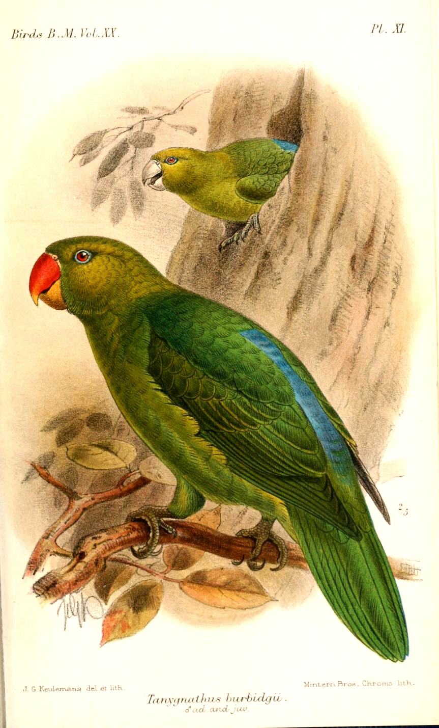
The blue-backed parrot (''Tanygnathus everetti''), also known as Müller's (or Mueller's) parrot is a large, endangered species of parrot endemic to the Philippines. It is found in tropical moist lowland forests. Flocks are small and often active at night. Its main threats are habitat loss and trapping for the pet trade. It is illegal to hunt, capture or possess blue-backed parrots under Philippine Law RA 9147. Taxonomy It was previously conspecific with the azure-rumped parrot (''T. sumatranus''), but was split as a distinct species by the IUCN Red List and BirdLife International in 2020, and the International Ornithological Congress followed suit in 2022. It can be differentiated from the azure-rumped parrot by its blue back and red iris vs. the azure-rumped parrot's yellow iris and plain green back. Subspecies There are four subspecies:. * ''T. e. burbidgii'': Sulu Islands. Darker green with lighter collar. Red iris. Much larger at 40cm * ''T. e. everetti'': Panay, ... [...More Info...] [...Related Items...] OR: [Wikipedia] [Google] [Baidu] |
Stamford Raffles
Sir Thomas Stamford Bingley Raffles (5 July 1781 – 5 July 1826) was a British statesman who served as the Lieutenant-Governor of the Dutch East Indies between 1811 and 1816, and Lieutenant-Governor of Bencoolen between 1818 and 1824. He is best known mainly for his founding of modern Singapore and the Straits Settlements also called Malaysia and Brunei. Raffles was heavily involved in the capture of the Indonesian island of Java from the Dutch during the Napoleonic Wars. The running of day-to-day operations on Singapore was mostly done by William Farquhar, but Raffles was the one who got all the credit. He also wrote '' The History of Java'' (1817). Early life Thomas Stamford Bingley Raffles was born on on board the ship ''Ann'', off the coast of Port Morant, Jamaica, to Captain Benjamin Raffles (1739, London – 23 November 1811, Deptford) and Anne Raffles (née Lyde) (1755 – 8 February 1824, London). Benjamin served as a ship master for various ships engaged in th ... [...More Info...] [...Related Items...] OR: [Wikipedia] [Google] [Baidu] |
Polillo Islands
The Polillo Islands is a group of about 27 islands in the Philippine Sea lying about to the east of the Philippine island of Luzon. It is separated from Luzon Island by the Polillo Strait and forms the northern side of Lamon Bay. The islands are part of the province of Quezon in the Calabarzon region of the Philippines. The combined land area of all the islands is about 875 square kilometers making Polillo islands even larger than the island city-state of Singapore. Major islands The three major islands are: *Polillo Island *Patnanungan Island *Jomalig Island These islands comprise the towns of Polillo, Patnanungan, Jomalig, Panukulan and Burdeos. The biggest Polillo Island is divided into three municipalities of Polillo, Burdeos, and Panukulan. Burdeos Bay lies in between the islands of Patnanungan and Polillo Polillo also includes the privately-owned resort island of Balesin, located further south in the middle of Lamon Bay. * Polillo (southern part of Pol ... [...More Info...] [...Related Items...] OR: [Wikipedia] [Google] [Baidu] |
Hybridization (biology)
In biology, a hybrid is the offspring resulting from combining the qualities of two organisms of different breeds, varieties, species or genera through sexual reproduction. Hybrids are not always intermediates between their parents (such as in blending inheritance), but can show hybrid vigor, sometimes growing larger or taller than either parent. The concept of a hybrid is interpreted differently in animal and plant breeding, where there is interest in the individual parentage. In genetics, attention is focused on the numbers of chromosomes. In taxonomy, a key question is how closely related the parent species are. Species are reproductively isolated by strong barriers to hybridisation, which include genetic and morphological differences, differing times of fertility, mating behaviors and cues, and physiological rejection of sperm cells or the developing embryo. Some act before fertilization and others after it. Similar barriers exist in plants, with differences in flowering tim ... [...More Info...] [...Related Items...] OR: [Wikipedia] [Google] [Baidu] |
Dinagat Islands
Dinagat Islands ( Cebuano: ''Mga Pulo sa Dinagat''; Surigaonon: ''Mga Puyo nan Dinagat''; Kabalian: ''Mga Puyo san Dinagat''; Waray: ''Mga Purô han Dinagat''; Filipino: ''Mga Islang Dinagat''), officially the Province of Dinagat Islands, is an island province in the Caraga region of the Philippines, located on the south side of Leyte Gulf. The island of Leyte is to its west, across Surigao Strait, and Mindanao is to its south. Its main island, Dinagat, is about from north to south. History The province is known as one of the archipelago's holiest sites in the Pre-Christian native religion. It is here where the God of Hurricanes was persuaded to relent his attacks on the islands by Da, the God of Peace. The province in pre-colonial times was much influenced by the Rajahnate of Butuan which was nestled in present-day Agusan del Norte. It was also used as the entry point of the Rahajnate of Ternate, present-day Moluccas of Indonesia, to attack the Rajahnate of Butuan, Rajahn ... [...More Info...] [...Related Items...] OR: [Wikipedia] [Google] [Baidu] |
Samar
Samar ( ) is the third-largest and seventh-most populous island in the Philippines, with a total population of 1,909,537 as of the 2020 census. It is located in the eastern Visayas, which are in the central Philippines. The island is divided into three provinces: Samar (formerly Western Samar), Northern Samar, and Eastern Samar. These three provinces, along with the provinces on the nearby islands of Leyte and Biliran, are part of the Eastern Visayas region. About a third of the island of Samar is protected as a natural park, known as the Samar Island Natural Park. On June 19, 1965, through Republic Act No. 4221, Samar was divided into three provinces: Northern Samar, (Western) Samar and Eastern Samar. The capitals of these provinces are, respectively, Catarman, Catbalogan City, and Borongan City. In commemoration of the establishment of these provinces, June 19 is celebrated as an annual holiday and many have the day off from work. Geography Samar is the third-l ... [...More Info...] [...Related Items...] OR: [Wikipedia] [Google] [Baidu] |
Catanduanes
Catanduanes (; ), officially the Province of Catanduanes, is an island province located in the Bicol Region of Luzon in the Philippines. It is the 12th-largest island in the Philippines, and lies to the east of Camarines Sur, across Maqueda Channel. Its capital is Virac. It had a population of 271,879 people as of the 2020 census. The province comprises Catanduanes Island (also called ''Virac Island''), Panay Island, Lete Island, the Palumbanes group of islands (Porongpong, Tignob and Calabagio), and a few other small, surrounding islets and rocks. The province is also home to various mollusk fossil sites, notably the second-oldest ammonite site in the Philippines. These sites have certain species of ammonites that are found nowhere else in Southeast Asia. Because of the province's importance and rich geologic history, various scholars have suggested that, if the province would take the initiative to put its name forward in nomination, it would stand a good chance of being ... [...More Info...] [...Related Items...] OR: [Wikipedia] [Google] [Baidu] |
Sulu
Sulu (), officially the Province of Sulu ( Tausūg: ''Wilāya sin Lupa' Sūg''; tl, Lalawigan ng Sulu), is a province of the Philippines in the Sulu Archipelago and part of the Bangsamoro Autonomous Region in Muslim Mindanao (BARMM). Its capital is Jolo on the island of the same name. Maimbung, the royal capital of the Sultanate of Sulu, is also located in the province. Sulu is along the southern border of the Sulu Sea and the northern boundary of the Celebes Sea. History Pre-Spanish and Spanish eras Prior to the arrival of Islam in Sulu, the province used to adhere to local animist religions; this later changed to Hindu and Buddhist belief systems. Throughout this time, the Kingdom of Lupah Sug had been established centuries before Islam arrived. The advent of Islam around 1138 through merchants and traders had a distinct influence on Southeast Asia. The coming of Arabs, Persians and other Muslims paved the way for the arrival of religious missionaries, traders, schol ... [...More Info...] [...Related Items...] OR: [Wikipedia] [Google] [Baidu] |
National List Of Threatened Terrestrial Fauna Of The Philippines
The National List of Threatened Terrestrial Fauna of the Philippines, also known as the Red List, is a list of endangered species endemic in the Philippines and is maintained by the Department of Environment and Natural Resources (DENR) through its Biodiversity Management Bureau and the Philippine Red List Committee. The list is pursuant to Republic Act No. 9147, or the Wildlife Resources Conservation and Protection Act. Species are assessed solely according to their population in the Philippines and hence may not be in line with other conversation lists such as the IUCN Red List which list the Crab-eating macaque (including subspecies the Philippine long-tailed macaque) as vulnerable but is not included in the 2019 release of the Philippines' national Red List. The list was first released in 2004. In 2019, arachnids and insects were added to the list for the first time. List The following is the list of critically endangered (CR) and endangered (EN) species included in the Natio ... [...More Info...] [...Related Items...] OR: [Wikipedia] [Google] [Baidu] |
Endangered Species (IUCN Status)
Endangered species as classified by the International Union for Conservation of Nature (IUCN), are species which have been categorized as very likely to become extinct in their known native ranges in the near future. On the IUCN Red List, endangered is the second most severe conservation status for wild populations in the IUCN's schema after critically endangered. In 2012, the IUCN Red List featured 3,079 animal and 2,655 plant species as endangered worldwide. The figures for 1998 were 1,102 and 1,197 respectively. IUCN Red List The IUCN Red List is a list of species which have been assessed according to a system of assigning a global conservation status. According to the latest system used by the IUCN, a species can be "Data Deficient" (DD) species – species for which more data and assessment is required before their situation may be determined – as well species comprehensively assessed by the IUCN's species assessment process. A species can be "Near ... [...More Info...] [...Related Items...] OR: [Wikipedia] [Google] [Baidu] |
Azure-rumped Parrot
The azure-rumped parrot (''Tanygnathus sumatranus''), is a large bird endemic to Indonesia. It is found in Sulawesi and the Sangir Islands. It was previously conspecific with the blue-backed parrot, which is differentiated with its red iris and blue-back versus the azure-rumped parrot's yellow iris and plain back. It is found in forests. Flocks are small and often active at night. Its main threats are habitat loss and trapping for the pet trade. Tax0nomy There are two subspecies: * ''T. s. sumatranus'' ( Raffles, 1822): Sulawesi. Sulawesi and nearby islands. Yellow iris. * ''T. s. sangirensis'' Meyer, AB & Wiglesworth, 1894: Sangir Islands and Karakelong Karakelong is the main island of the Talaud Islands north east of Sulawesi, Indonesia. Its area is . It has a population of 51,506 at the 2010 Census and 59,920 at the 2020 Census.Badan Pusat Statistik, Jakarta, 2021. Its largest town is Melong .... More blue on wing bends and wing coverts, head darker green. Yello ... [...More Info...] [...Related Items...] OR: [Wikipedia] [Google] [Baidu] |


