|
Typhoon Mitag (2019)
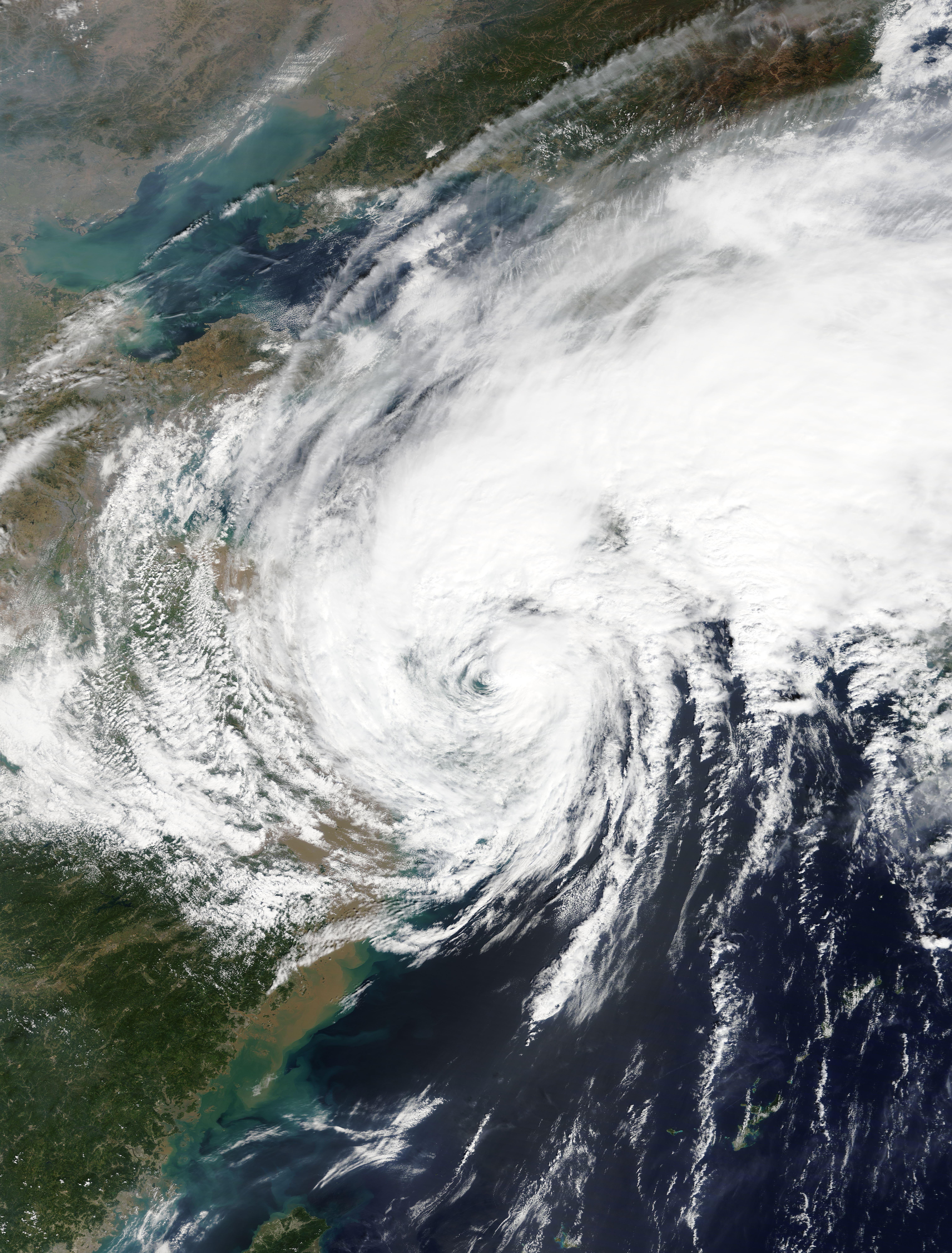
Typhoon Mitag, known in the Philippines as Typhoon Onyok, was a moderately strong tropical cyclone that severely affected Taiwan, East China and South Korea in early October 2019. The 23rd depression and the 8th typhoon of the 2019 Pacific typhoon season, Mitag developed from a low pressure system near the Micronesia Islands on September 24. Tracking generally northwestward, the system gradually organised and the Japanese Meteorological Agency issued its first advisory on Tropical Depression 19W on September 27. It continued northeastward, gradually organizing and becoming less broad. It was then upgraded to Tropical Storm Mitag on September 28. The storm quickly intensified, becoming a Category 1 typhoon just a day later. It further intensified into a Category 2 typhoon, passing very close to Taiwan. It weakened thereafter, making landfall near Zhoushan in East China on October 1 before weakening back to a poorly organized tropical storm. It later made landfall in South Korea on ... [...More Info...] [...Related Items...] OR: [Wikipedia] [Google] [Baidu] |
Taiwan
Taiwan, officially the Republic of China (ROC), is a country in East Asia, at the junction of the East and South China Seas in the northwestern Pacific Ocean, with the People's Republic of China (PRC) to the northwest, Japan to the northeast, and the Philippines to the south. The territories controlled by the ROC consist of 168 islands, with a combined area of . The main island of Taiwan, also known as ''Formosa'', has an area of , with mountain ranges dominating the eastern two-thirds and plains in the western third, where its highly urbanised population is concentrated. The capital, Taipei, forms along with New Taipei City and Keelung the largest metropolitan area of Taiwan. Other major cities include Taoyuan, Taichung, Tainan, and Kaohsiung. With around 23.9 million inhabitants, Taiwan is among the most densely populated countries in the world. Taiwan has been settled for at least 25,000 years. Ancestors of Taiwanese indigenous peoples settled the isla ... [...More Info...] [...Related Items...] OR: [Wikipedia] [Google] [Baidu] |
PAGASA
Pagasa may refer to: * ''Pagasa'' (genus), an insect genus in the family Nabidae *PAGASA, an acronym for the Philippine Atmospheric, Geophysical and Astronomical Services Administration *"May Pagasa", a pen-name of José Rizal *Pagasa, alternate spelling of Pagasae Pagasae or Pagases ( el, Παγασαί, Pagasaí), also Pagasa, was a town and polis (city-state) of Magnesia in ancient Thessaly, currently a suburb of Volos. It is situated at the northern extremity of the bay named after it (Παγασητι� ..., a city of ancient Thessaly See also * Pag-asa (other) {{dab ... [...More Info...] [...Related Items...] OR: [Wikipedia] [Google] [Baidu] |
Weather Of 2019
The following is a list of weather events in 2019. Global conditions 2019 was Earth's second-warmest year on record, which goes back to 1880. It was the 43rd consecutive year of above-average temperatures. The year was 0.95 °C (1.71 °F) above the 20th century average, and 0.07 °C (0.04 °F) behind 2016, which was the warmest year on record. 2019 fell to the third-warmest year on record when the following year surpassed it. In 2019, Australia and the U.S. state of Alaska recorded their warmest years on record. There is a previous El Niño episode continuing from last year, and new El Niño episode started this year, lasting until 2020. Summary by weather type Winter storms and cold waves From January 16 to 19, a winter storm crosses the United States, killing ten. Then, from January 24 into February, a cold wave brought record low temperatures to the United States. Illinois set a statewide record low temperature. Twenty-two people die as a result ... [...More Info...] [...Related Items...] OR: [Wikipedia] [Google] [Baidu] |
Cagayan Valley
Cagayan Valley ( ilo, Tanap ti Cagayan; fil, Lambak ng Cagayan), is an administrative region in the Philippines, located in the northeastern section of Luzon Island. It is composed of five Philippine provinces: Batanes, Cagayan, Isabela, Nueva Vizcaya, and Quirino. The region hosts four chartered cities of Cauayan, Ilagan, Santiago, and Tuguegarao. Most of the land area is situated on the valley between the Cordilleras and the Sierra Madre mountain ranges. The eponymous Cagayan River, the country's largest and longest, runs through the region and flows from the Caraballo Mountains and ends at Aparri. Cagayan Valley is the second largest Philippine administrative region by land area. According to a literacy survey in 2013, 97.2% of Cagayan Valley's citizens (ages 10 to 64) are functionally literate, which is the highest out of the seventeen regions of the Philippines. History Archaeology indicates that Cagayan has been inhabited for half a million years, though no hu ... [...More Info...] [...Related Items...] OR: [Wikipedia] [Google] [Baidu] |
Babuyan
The Babuyan Islands ( ), also known as the Babuyan Group of Islands, is an archipelago in the Philippines, located in the Luzon Strait north of the main island of Luzon and south of Taiwan via Bashi Channel to Luzon Strait. The archipelago consists of five major islands and their surrounding smaller islands. These main islands are, counterclockwise starting from northeast, Babuyan, Calayan, Dalupiri, Fuga, and Camiguin. The Babuyan Islands are separated from Luzon by the Babuyan Channel, and from the province of Batanes to the north by the Balintang Channel. Geography The archipelago, comprising 24 volcanic-coralline islands, has a total area of about . The largest of these is Calayan with an area of , while the highest peak in the island group is Mount Pangasun () on Babuyan Claro. Islands The following are the islands of Babuyan and their adjoining islets and rocks, along with land areas and highest elevation: Geology The eastern islands of the archipelago are part o ... [...More Info...] [...Related Items...] OR: [Wikipedia] [Google] [Baidu] |
Batanes
Batanes, officially the Province of Batanes ( ivv, Provinsiya nu Batanes; Ilocano: ''Probinsia ti Batanes''; fil, Lalawigan ng Batanes, ), is an archipelagic province in the Philippines, administratively part of the Cagayan Valley region. It is the northernmost province in the country, and also the smallest, both in population and land area. The capital is Basco, located on the island of Batan. The island group is located approximately north of the Luzon mainland and about south of Taiwan ( Pingtung County), separated from the Babuyan Islands of Cagayan Province by the Balintang Channel, and from Taiwan by the Bashi Channel. The entire province is listed in the UNESCO tentative list for inscription in the World Heritage List. The government has been finalizing the site's inscription, establishing museums and conservation programs since 2001. Seven intangible heritage elements of the Ivatan have been set by the Philippine government in its initial inventory in 2012. The e ... [...More Info...] [...Related Items...] OR: [Wikipedia] [Google] [Baidu] |
Luzon
Luzon (; ) is the largest and most populous island in the Philippines. Located in the northern portion of the Philippines archipelago, it is the economic and political center of the nation, being home to the country's capital city, Manila, as well as Quezon City, the country's most populous city. With a population of 64 million , it contains 52.5% of the country's total population and is the fourth most populous island in the world. It is the 15th largest island in the world by land area. ''Luzon'' may also refer to one of the three primary island groups in the country. In this usage, it includes the Luzon mainland, the Batanes and Babuyan groups of islands to the north, Polillo Islands to the east, and the outlying islands of Catanduanes, Marinduque and Mindoro, among others, to the south. The islands of Masbate, Palawan and Romblon are also included, although these three are sometimes grouped with another of the island groups, the Visayas. Etymology The name ''Luz ... [...More Info...] [...Related Items...] OR: [Wikipedia] [Google] [Baidu] |
Sea Surface Temperature
Sea surface temperature (SST), or ocean surface temperature, is the ocean temperature close to the surface. The exact meaning of ''surface'' varies according to the measurement method used, but it is between and below the sea surface. Air masses in the Earth's atmosphere are highly modified by sea surface temperatures within a short distance of the shore. Localized areas of heavy snow can form in bands downwind of warm water bodies within an otherwise cold air mass. Warm sea surface temperatures are known to be a cause of tropical cyclogenesis over the Earth's oceans. Tropical cyclones can also cause a cool wake, due to turbulent mixing of the upper of the ocean. SST changes diurnally, like the air above it, but to a lesser degree. There is less SST variation on breezy days than on calm days. In addition, ocean currents such as the Atlantic Multidecadal Oscillation (AMO), can affect SST's on multi-decadal time scales, a major impact results from the global thermohaline ci ... [...More Info...] [...Related Items...] OR: [Wikipedia] [Google] [Baidu] |
Japan Sea
The Sea of Japan is the marginal sea between the Japanese archipelago, Sakhalin, the Korean Peninsula, and the mainland of the Russian Far East. The Japanese archipelago separates the sea from the Pacific Ocean. Like the Mediterranean Sea, it has almost no tides due to its nearly complete enclosure from the Pacific Ocean. This isolation also affects faunal diversity and salinity, both of which are lower than in the open ocean. The sea has no large islands, bays or capes. Its water balance is mostly determined by the inflow and outflow through the straits connecting it to the neighboring seas and the Pacific Ocean. Few rivers discharge into the sea and their total contribution to the water exchange is within 1%. The seawater has an elevated concentration of dissolved oxygen that results in high biological productivity. Therefore, fishing is the dominant economic activity in the region. The intensity of shipments across the sea has been moderate owing to political issues, but it i ... [...More Info...] [...Related Items...] OR: [Wikipedia] [Google] [Baidu] |
Philippines
The Philippines (; fil, Pilipinas, links=no), officially the Republic of the Philippines ( fil, Republika ng Pilipinas, links=no), * bik, Republika kan Filipinas * ceb, Republika sa Pilipinas * cbk, República de Filipinas * hil, Republika sang Filipinas * ibg, Republika nat Filipinas * ilo, Republika ti Filipinas * ivv, Republika nu Filipinas * pam, Republika ning Filipinas * krj, Republika kang Pilipinas * mdh, Republika nu Pilipinas * mrw, Republika a Pilipinas * pag, Republika na Filipinas * xsb, Republika nin Pilipinas * sgd, Republika nan Pilipinas * tgl, Republika ng Pilipinas * tsg, Republika sin Pilipinas * war, Republika han Pilipinas * yka, Republika si Pilipinas In the recognized optional languages of the Philippines: * es, República de las Filipinas * ar, جمهورية الفلبين, Jumhūriyyat al-Filibbīn is an archipelagic country in Southeast Asia. It is situated in the western Pacific Ocean and consists of around 7,641 islands t ... [...More Info...] [...Related Items...] OR: [Wikipedia] [Google] [Baidu] |
Extratropical Cyclone
Extratropical cyclones, sometimes called mid-latitude cyclones or wave cyclones, are low-pressure areas which, along with the anticyclones of high-pressure areas, drive the weather over much of the Earth. Extratropical cyclones are capable of producing anything from cloudiness and mild showers to severe gales, thunderstorms, blizzards, and tornadoes. These types of cyclones are defined as large scale (synoptic) low pressure weather systems that occur in the middle latitudes of the Earth. In contrast with tropical cyclones, extratropical cyclones produce rapid changes in temperature and dew point along broad lines, called weather fronts, about the center of the cyclone. Terminology The term " cyclone" applies to numerous types of low pressure areas, one of which is the extratropical cyclone. The descriptor ''extratropical'' signifies that this type of cyclone generally occurs outside the tropics and in the middle latitudes of Earth between 30° and 60° latitude. They are term ... [...More Info...] [...Related Items...] OR: [Wikipedia] [Google] [Baidu] |


