|
Typhoon Gilda (1974)
Typhoon Gilda, known in the Philippines as Typhoon Deling was a destructive, deadly, costly and long-lived tropical cyclone that left over 145 confirmed deaths over Japan and South Korea, mostly due to torrential rainfall that induced landslides, all generated by the typhoon and its associated meiyu front. The eighth named storm and third typhoon of the 1974 Pacific typhoon season, the system was first noted by the China Meteorological Agency as an area of convection embedded on a trough, to the north of Enewetak Atoll on June 25. It was named ''Gilda'' on June 30 as it strengthened to a tropical storm. Under a favorable environment, it strengthened to a typhoon two days later as it moved northwestward. Another trough pulled Gilda poleward while changing less in intensity, until it intensified to a Category 2 typhoon as it battered the Ryukyu Islands at its peak. Increasing wind shear gradually weakened the system; however, it remained as a minimal typhoon until it passed throug ... [...More Info...] [...Related Items...] OR: [Wikipedia] [Google] [Baidu] |
Northern Mariana Islands
The Northern Mariana Islands, officially the Commonwealth of the Northern Mariana Islands (CNMI; ch, Sankattan Siha Na Islas Mariånas; cal, Commonwealth Téél Falúw kka Efáng llól Marianas), is an unincorporated territory and commonwealth of the United States consisting of 14 islands in the northwestern Pacific Ocean.Lin, Tom C.W.Americans, Almost and Forgotten 107 California Law Review (2019) The CNMI includes the 14 northernmost islands in the Mariana Archipelago; the southernmost island, Guam, is a separate U.S. territory. The United States Department of the Interior cites a landmass of . According to the 2020 United States Census, 47,329 people were living in the CNMI at that time. The vast majority of the population resides on Saipan, Tinian, and Rota. The other islands of the Northern Marianas are sparsely inhabited; the most notable among these is Pagan, which for various reasons over the centuries has experienced major population flux, but formerly had res ... [...More Info...] [...Related Items...] OR: [Wikipedia] [Google] [Baidu] |
Hokkaido
is Japan's second largest island and comprises the largest and northernmost prefecture, making up its own region. The Tsugaru Strait separates Hokkaidō from Honshu; the two islands are connected by the undersea railway Seikan Tunnel. The largest city on Hokkaidō is its capital, Sapporo, which is also its only ordinance-designated city. Sakhalin lies about 43 kilometers (26 mi) to the north of Hokkaidō, and to the east and northeast are the Kuril Islands, which are administered by Russia, though the four most southerly are claimed by Japan. Hokkaidō was formerly known as ''Ezo'', ''Yezo'', ''Yeso'', or ''Yesso''. Nussbaum, Louis-Frédéric. (2005). "Hokkaidō" in Although there were Japanese settlers who ruled the southern tip of the island since the 16th century, Hokkaido was considered foreign territory that was inhabited by the indigenous people of the island, known as the Ainu people. While geographers such as Mogami Tokunai and Mamiya Rinzō explored the isla ... [...More Info...] [...Related Items...] OR: [Wikipedia] [Google] [Baidu] |
Pacific Ocean
The Pacific Ocean is the largest and deepest of Earth's five oceanic divisions. It extends from the Arctic Ocean in the north to the Southern Ocean (or, depending on definition, to Antarctica) in the south, and is bounded by the continents of Asia and Oceania in the west and the Americas in the east. At in area (as defined with a southern Antarctic border), this largest division of the World Ocean—and, in turn, the hydrosphere—covers about 46% of Earth's water surface and about 32% of its total surface area, larger than Earth's entire land area combined .Pacific Ocean . '' Britannica Concise.'' 2008: Encyclopædia Britannica, Inc. The centers of both the |
Extratropical
Extratropical cyclones, sometimes called mid-latitude cyclones or wave cyclones, are low-pressure areas which, along with the anticyclones of high-pressure areas, drive the weather over much of the Earth. Extratropical cyclones are capable of producing anything from cloudiness and mild showers to severe gales, thunderstorms, blizzards, and tornadoes. These types of cyclones are defined as large scale (synoptic) low pressure weather systems that occur in the middle latitudes of the Earth. In contrast with tropical cyclones, extratropical cyclones produce rapid changes in temperature and dew point along broad lines, called weather fronts, about the center of the cyclone. Terminology The term "cyclone" applies to numerous types of low pressure areas, one of which is the extratropical cyclone. The descriptor ''extratropical'' signifies that this type of cyclone generally occurs outside the tropics and in the middle latitudes of Earth between 30° and 60° latitude. They are termed ... [...More Info...] [...Related Items...] OR: [Wikipedia] [Google] [Baidu] |
Manchuria
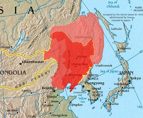
Manchuria is an exonym (derived from the endo demonym " Manchu") for a historical and geographic region in Northeast Asia encompassing the entirety of present-day Northeast China (Inner Manchuria) and parts of the Russian Far East (Outer Manchuria). Its meaning may vary depending on the context: * Historical polities and geographical regions usually referred to as Manchuria: ** The Later Jin (1616–1636), the Manchu-led dynasty which renamed itself from "Jin" to "Qing", and the ethnicity from "Jurchen" to "Manchu" in 1636 ** the subsequent duration of the Qing dynasty prior to its conquest of China proper (1644) ** the northeastern region of Qing dynasty China, the homeland of Manchus, known as "Guandong" or "Guanwai" during the Qing dynasty ** The region of Northeast Asia that served as the historical homeland of the Jurchens and later their descendants Manchus ***Qing control of Dauria (the region north of the Amur River, but in its watershed) was contested in 1643 when ... [...More Info...] [...Related Items...] OR: [Wikipedia] [Google] [Baidu] |
Sea Surface Temperatures
Sea surface temperature (SST), or ocean surface temperature, is the ocean temperature close to the surface. The exact meaning of ''surface'' varies according to the measurement method used, but it is between and below the sea surface. Air masses in the Earth's atmosphere are highly modified by sea surface temperatures within a short distance of the shore. Localized areas of heavy snow can form in bands downwind of warm water bodies within an otherwise cold air mass. Warm sea surface temperatures are known to be a cause of tropical cyclogenesis over the Earth's oceans. Tropical cyclones can also cause a cool wake, due to turbulent mixing of the upper of the ocean. SST changes diurnally, like the air above it, but to a lesser degree. There is less SST variation on breezy days than on calm days. In addition, ocean currents such as the Atlantic Multidecadal Oscillation (AMO), can affect SST's on multi-decadal time scales, a major impact results from the global thermohaline cir ... [...More Info...] [...Related Items...] OR: [Wikipedia] [Google] [Baidu] |
Reconnaissance Aircraft
A reconnaissance aircraft (colloquially, a spy plane) is a military aircraft designed or adapted to perform aerial reconnaissance with roles including collection of imagery intelligence (including using photography), signals intelligence, as well as measurement and signature intelligence. Modern technology has also enabled some aircraft and UAVs to carry out real-time surveillance in addition to general intelligence gathering. Before the development of devices such as radar, military forces relied on reconnaissance aircraft for visual observation and scouting of enemy movement. An example is the PBY Catalina maritime patrol flying boat used by the Allies in World War II: a flight of U.S. Navy Catalinas spotted part of the Japanese fleet approaching Midway Island, beginning the Battle of Midway. History Prior to the 20th century machines for powered and controllable flight were not available to military forces, but some attempts were made to use lighter than air craft ... [...More Info...] [...Related Items...] OR: [Wikipedia] [Google] [Baidu] |
East China
East China () is a geographical and a loosely defined cultural region that covers the eastern coastal area of China. A concept abolished in 1978, for economical purposes the region was defined from 1949 to 1961 by the Chinese Central Government to include the provinces of (in alphabetical order) Anhui, Fujian, Jiangsu, Shandong and Zhejiang, as well as the municipality of Shanghai. In 1961, the province of Jiangxi was added to the region (previously it was considered part of South Central China). Since the Chinese government claims Taiwan and the few outlying islands of Fujian (Kinmen and Matsu) governed by the Republic of China (Taiwanese government) as its territory, the claimed "Taiwan Province, People's Republic of China" was once classified in this region. Administrative divisions Cities with urban area over one million in population Provincial capitals in bold. See also * Yangtze River Delta The Yangtze Delta or Yangtze River Delta (YRD, or simply ) is ... [...More Info...] [...Related Items...] OR: [Wikipedia] [Google] [Baidu] |
Joint Typhoon Warning Center
The Joint typhoon Warning Center (JTWC) is a joint United States Navy – United States Air Force command in Pearl Harbor, Hawaii. The JTWC is responsible for the issuing of tropical cyclone warnings in the North-West Pacific Ocean, South Pacific Ocean, and Indian Ocean for all branches of the U.S. Department of Defense and other U.S. government agencies. Their warnings are intended for the protection of primarily military ships and aircraft as well as military installations jointly operated with other countries around the world. Its U.S. Navy components are aligned with the Naval Meteorology and Oceanography Command. History The origins of the Joint Typhoon Warning Center (JTWC) can be traced back to June 1945, when the Fleet Weather Center/Typhoon Tracking Center was established on the island of Guam, after multiple typhoons, including Typhoon Cobra of December 1944 and Typhoon Connie in June 1945, had caused a significant loss of men and ships. At this time the center ... [...More Info...] [...Related Items...] OR: [Wikipedia] [Google] [Baidu] |
Japan Meteorological Agency
The , abbreviated JMA, is an agency of the Ministry of Land, Infrastructure, Transport and Tourism. It is charged with gathering and providing results for the public in Japan that are obtained from data based on daily scientific observation and research into natural phenomena in the fields of meteorology, hydrology, seismology and volcanology, among other related scientific fields. Its headquarters is located in Minato, Tokyo. JMA is responsible for gathering and reporting weather data and forecasts for the general public, as well as providing aviation and marine weather. JMA other responsibilities include issuing warnings for volcanic eruptions, and the nationwide issuance of earthquake warnings of the Earthquake Early Warning (EEW) system. JMA is also designated one of the Regional Specialized Meteorological Centers of the World Meteorological Organization (WMO). It is responsible for forecasting, naming, and distributing warnings for tropical cyclones in the Northwestern ... [...More Info...] [...Related Items...] OR: [Wikipedia] [Google] [Baidu] |
Hong Kong Observatory
The Hong Kong Observatory is a weather forecast agency of the government of Hong Kong. The Observatory forecasts the weather and issues warnings on weather-related hazards. It also monitors and makes assessments on radiation levels in Hong Kong and provides other meteorological and geophysical services to meet the needs of the public and the shipping, aviation, industrial and engineering sectors. Overview The Observatory was established on 2 March 1883 as the Hong Kong Observatory by Sir George Bowen, the 9th Governor of Hong Kong, with (1852–1941) as its first director. Early operations included meteorological and magnetic observations, a time service based on astronomical observations and a tropical cyclone warning service. The Observatory was renamed the Royal Observatory Hong Kong () after obtaining a Royal Charter in 1912. The Observatory adopted the current name and emblem in 1997 after the Handover of Hong Kong, transfer of Hong Kong's sovereignty from the UK ... [...More Info...] [...Related Items...] OR: [Wikipedia] [Google] [Baidu] |
Midway Atoll
Midway Atoll (colloquial: Midway Islands; haw, Kauihelani, translation=the backbone of heaven; haw, Pihemanu, translation=the loud din of birds, label=none) is a atoll in the North Pacific Ocean. Midway Atoll is an insular area of the United States and is an unorganized and unincorporated territory. The largest island is Sand Island, which has housing and an airstrip. Immediately to the east of Sand Island across the narrow Brooks Channel is Eastern Island, which is uninhabited and no longer has any facilities. Forming a rough, incomplete circle around the two main islands and creating Midway Lagoon is Spit Island, a narrow reef. Roughly equidistant between North America and Asia, Midway is the only island in the Hawaiian Archipelago that is not part of the state of Hawaii. Unlike the other Hawaiian islands, Midway observes Samoa Time ( UTC−11:00, i.e., eleven hours behind Coordinated Universal Time), which is one hour behind the time in the Hawaii–Aleutian Time Zone ... [...More Info...] [...Related Items...] OR: [Wikipedia] [Google] [Baidu] |

.jpg)


.jpg)


