|
Tuni
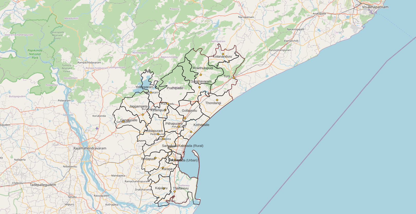
Tuni is a city in Kakinada district of the Indian state of Andhra Pradesh. It is a second biggest city in kakinada district. It is a major commercial marketing center for more than 100 surrounding villages in the district. Tuni is a border point for the district of Kakinada. It is known for mango production, with nearly 250 varieties being exported from the area. Tuni is also famous for the production of betel leaves and jute bags. A variety of cashew nuts are also produced in Tuni. History Tuni as a historical site may date back to the 1st century CE in connection with Buddhism, which flourished in the nearby hillocks and villages such as Gopalapatnam, Satyavaram and Kummarilova, near the city of Tuni on the banks of the Thandava River. The Buddhist monks would have resided in Kummarilova village (Kummararam) from the 2nd century CE to 6th century CE and propagated Buddhism. The Buddhist 'aramas' and 'stupas' found in the village are testimony for their presence, they ... [...More Info...] [...Related Items...] OR: [Wikipedia] [Google] [Baidu] |
Kakinada District
Kakinada district is a district in the Coastal Andhra Region in the Indian state of Andhra Pradesh. With Kakinada as its administrative headquarters, it was proposed on 26 January 2022 to become one of the resultant twenty six districts in the state after the final notification has been issued on 4 April 2022 by the government of Andhra Pradesh. The district was formed from Kakinada and Peddapuram revenue divisions from East Godavari district. Incidentally, during earlier times, the region comprising towns Pithapuram, Kakinada and Peddapuram were referred as ''Polnaud'' or ''Prolunadu'' (), which now roughly corresponds to the areas in this district. Etymology This district name derives from its headquarters Kakinada. Geography This district is surrounded by North of Alluri Sitharama Raju district, South of Bay of Bengal & Yanam district, East of Anakapalli district and west of East Godavari district & Konaseema district. Administrative divisions The district has two r ... [...More Info...] [...Related Items...] OR: [Wikipedia] [Google] [Baidu] |
Coastal Andhra
Coastal Andhra (South costal Andhra) also known as Coastal Andhra, Kostha Andhra is a region in the state of Andhra Pradesh, India. Vijayawada is the largest city in this region. It was part of Madras State before 1953 and Andhra State from 1953 to 1956. According to the 2011 census, it has an area of which is 57.99% of the total state area and a population of 34,193,868 which is 69.20% of Andhra Pradesh state population. This area includes the coastal districts of Andhra Pradesh on the Circar Coast between the Eastern Ghats and the Bay of Bengal, from the northern border with Odisha to Tirupati district in the South. Coastal Andhra has rich agricultural land, owing to the delta of the Godavari Krishna river and Penna River, Penna. The prosperity of Coastal Andhra can be attributed to its rich agricultural land and an abundant water supply from these three rivers. Rice grown in paddy fields is the main crop, with pulses and coconuts also being important. The fishing indust ... [...More Info...] [...Related Items...] OR: [Wikipedia] [Google] [Baidu] |
Kakinada
Kakinada ( formerly called Kakinandiwada, Coringa, and Cocanada; ) is the sixth largest city of the Indian state of Andhra Pradesh and serves as the district headquarters of the Kakinada District. It lies on the coast of the Bay of Bengal. J.N.T.U. College of Engineering Kakinada, established in 1946, is the oldest and popular Government college in the state of Andhra Pradesh. The First Polytechnic college of Andhra Pradesh, Andhra Polytechnic was established here in 1946. It was also the origin point of Buckingham Canal where goods used to be transported by boats during the British rule. It was once home for Asia's largest sea port (now near the village Coringa). Many people from the city migrated from this sea port to countries like Burma, Mauritius, Fiji and various southeast Asian countries to work there as workers where they were called as Coringas. Kakinada is also one of the fastest growing city in Andhra Pradesh. Kakinada is known for its sweet called kaja which ... [...More Info...] [...Related Items...] OR: [Wikipedia] [Google] [Baidu] |
Vehicle Registration Plates Of India
All motorised road vehicles in India are tagged with a registration or licence number. The Vehicle registration plate (commonly known as number plate) number is issued by the district-level Regional Transport Office (RTO) of respective states — the main authority on road matters. The number plates are placed in the front and back of the vehicle. By law, all plates are required to be in modern Hindu-Arabic numerals with Latin letters. The international vehicle registration code for India is IND. Colour coding Permanent Registration * Private vehicles: ** Private vehicles, by default, have black lettering on a white background (e.g. ). ** Vehicles which run purely on electricity have white lettering on a green background (e.g. ) * Commercial vehicles: ** Commercial vehicles such as taxis, buses and trucks, by default, have black lettering on a yellow background (e.g. ). ** Vehicles available on rent for self-drive have yellow lettering on a black background (e.g. ). ** ... [...More Info...] [...Related Items...] OR: [Wikipedia] [Google] [Baidu] |
Howrah
Howrah (, , alternatively spelled as Haora) is a city in the Indian state of West Bengal. Howrah is located on the western bank of the Hooghly River opposite its twin city of Kolkata. Administratively it lies within Howrah district, and is the headquarters of the Howrah Sadar subdivision. It is a part of the area covered by the Kolkata Metropolitan Development Authority. Howrah is an important transportation hub and gateway to Kolkata and West Bengal. Etymology The name came from the word '' Haor''— Bengali word for a fluvial swampy lake, which is sedimentologically a depression where water, mud and organic debris accumulate. The word itself was rather used in eastern part of Bengal (now Bangladesh), as compared to the western part (now West Bengal). History The history of the city of Howrah dates back over 500 years, but the district is situated in an area historically occupied by the ancient Bengali kingdom of Bhurshut. Venetian explorer Cesare Federici, who travelled ... [...More Info...] [...Related Items...] OR: [Wikipedia] [Google] [Baidu] |
Buddhism
Buddhism ( , ), also known as Buddha Dharma and Dharmavinaya (), is an Indian religion or philosophical tradition based on teachings attributed to the Buddha. It originated in northern India as a -movement in the 5th century BCE, and gradually spread throughout much of Asia via the Silk Road. It is the world's fourth-largest religion, with over 520 million followers (Buddhists) who comprise seven percent of the global population. The Buddha taught the Middle Way, a path of spiritual development that avoids both extreme asceticism and hedonism. It aims at liberation from clinging and craving to things which are impermanent (), incapable of satisfying ('), and without a lasting essence (), ending the cycle of death and rebirth (). A summary of this path is expressed in the Noble Eightfold Path, a training of the mind with observance of Buddhist ethics and meditation. Other widely observed practices include: monasticism; "taking refuge" in the Buddha, the , and the ... [...More Info...] [...Related Items...] OR: [Wikipedia] [Google] [Baidu] |
Gopalapatnam
Gopalapatnam is a neighborhood in the city of Visakhapatnam, India. The neighborhood is considered to be the major residential and commercial area in the district. It is located within the jurisdiction of the Greater Visakhapatnam Municipal Corporation, which is responsible for the area's civic amenities. It is located on the western fringe of Visakhapatnam. The Visakhapatnam gas leak occurred in the neighborhood on 7 May 2020. The Gopalapatnam Mandal is one of the 46 mandals of the Visakhapatnam District. It is under the administration of the Visakhapatnam Revenue Division, which is headquartered in Gopalapatnam. The Mandal is neighbored by the Gajuwaka, Seethammadhara, and Pendurthi mandals. Wards The Gopalapatnam Mandal consists of the following wards: Location and geography Gopalapatnam is located around 4 km from Visakhapatnam Airport and around 8 km from the Visakhapatnam Railway Station. The neighborhood is served by the Waltair Division's Simha ... [...More Info...] [...Related Items...] OR: [Wikipedia] [Google] [Baidu] |
Stupas
A stupa ( sa, स्तूप, lit=heap, ) is a mound-like or hemispherical structure containing relics (such as '' śarīra'' – typically the remains of Buddhist monks or nuns) that is used as a place of meditation. In Buddhism, circumambulation or '' pradakhshina'' has been an important ritual and devotional practice since the earliest times, and stupas always have a ''pradakhshina'' path around them. The original South Asian form is a large solid dome above a tholobate or drum with vertical sides, which usually sits on a square base. There is no access to the inside of the structure. In large stupas there may be walkways for circumambulation on top of the base as well as on the ground below it. Large stupas have or had ''vedikā'' railings outside the path around the base, often highly decorated with sculpture, especially at the torana gateways, of which there are usually four. At the top of the dome is a thin vertical element, with one of more horizontal discs spreadi ... [...More Info...] [...Related Items...] OR: [Wikipedia] [Google] [Baidu] |
British India
The provinces of India, earlier presidencies of British India and still earlier, presidency towns, were the administrative divisions of British governance on the Indian subcontinent. Collectively, they have been called British India. In one form or another, they existed between 1612 and 1947, conventionally divided into three historical periods: *Between 1612 and 1757 the East India Company set up factories (trading posts) in several locations, mostly in coastal India, with the consent of the Mughal emperors, Maratha Empire or local rulers. Its rivals were the merchant trading companies of Portugal, Denmark, the Netherlands, and France. By the mid-18th century, three ''presidency towns'': Madras, Bombay and Calcutta, had grown in size. *During the period of Company rule in India (1757–1858), the company gradually acquired sovereignty over large parts of India, now called "presidencies". However, it also increasingly came under British government oversight, in effect shar ... [...More Info...] [...Related Items...] OR: [Wikipedia] [Google] [Baidu] |
Madras
Chennai (, ), formerly known as Madras (List of renamed Indian cities and states#Tamil Nadu, the official name until 1996), is the capital city of Tamil Nadu, the southernmost states and territories of India, Indian state. The largest city of the state in area and population, Chennai is located on the Coromandel Coast of the Bay of Bengal. According to the 2011 Indian census, Chennai is the List of most populous cities in India, sixth-most populous city in the country and forms the List of million-plus urban agglomerations in India, fourth-most populous urban agglomeration. The Greater Chennai Corporation is the civic body responsible for the city; it is the oldest city corporation of India, established in 1688—the second oldest in the world after London. The city of Chennai is coterminous with Chennai district, which together with the adjoining suburbs constitutes the Chennai Metropolitan Area, the List of urban areas by population, 36th-largest urban area in the world by ... [...More Info...] [...Related Items...] OR: [Wikipedia] [Google] [Baidu] |
Jute
Jute is a long, soft, shiny bast fiber that can be spun into coarse, strong threads. It is produced from flowering plants in the genus ''Corchorus'', which is in the mallow family Malvaceae. The primary source of the fiber is ''Corchorus olitorius'', but such fiber is considered inferior to that derived from ''Corchorus capsularis''. "Jute" is the name of the plant or fiber used to make burlap, hessian, or gunny cloth. Jute is one of the most affordable natural fibers and second only to cotton in the amount produced and variety of uses. Jute fibers are composed primarily of plant materials cellulose and lignin. Jute fiber falls into the bast fiber category (fiber collected from bast, the phloem of the plant, sometimes called the "skin") along with kenaf, industrial hemp, flax (linen), ramie, etc. The industrial term for jute fiber is ''raw jute''. The fibers are off-white to brown and 1–4 meters (3–13 feet) long. Jute is also called the "golden fiber" for its color and hi ... [...More Info...] [...Related Items...] OR: [Wikipedia] [Google] [Baidu] |


