|
Pindos
The Pindus (also Pindos or Pindhos; el, Πίνδος, Píndos; sq, Pindet; rup, Pindu) is a mountain range located in Northern Greece and Southern Albania. It is roughly 160 km (100 miles) long, with a maximum elevation of 2,637 metres (8652') (Mount Smolikas). Because it runs along the border of Thessaly and Epirus, the Pindus range is known colloquially as the ''spine of Greece''. The mountain range stretches from near the Greek-Albanian border in southern Albania, entering the Epirus and Macedonia regions in northern Greece down to the north of the Peloponnese. Geologically it is an extension of the Dinaric Alps, which dominate the western region of the Balkan Peninsula. History of the name Historically, the name Pindos refers to the mountainous territory that separates the greater Epirus region from the regions of Macedonia and Thessaly. According to John Tzetzes (a 12th-century Byzantine writer), the Pindos range was then called Metzovon. When translated ( ... [...More Info...] [...Related Items...] OR: [Wikipedia] [Google] [Baidu] |
Samarina
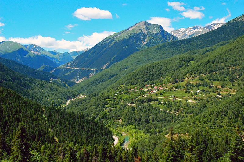
Samarina ( el, Σαμαρίνα, rup, Samarina, Xamarina, San Marina) is a village and a former municipality in Grevena regional unit, West Macedonia, Greece. Since the 2011 local government reform it is part of the municipality Grevena, of which it is a municipal unit. Its population primarily consists of Aromanians (sometimes called Vlachs). It attracts many tourists due to its scenic location and beautiful pine and beech forests. The population was 378 people as of 2011. The municipal unit has an area of 97.245 km2 (37½ sq. mi.). Samarina is the most famous of all the Aromanian (Vlach) villages of the Pindus and the inhabitants are fiercely proud of their heritage and traditions. Every summer on August 15, on the feast of the Dormition of the Virgin, Samarinans from all over the world assemble on their ancestral village to celebrate. There, on the main square outside the Great Church, they perform the "Great Dance" (Greek: ''Tranós Chorós'', Aromanian: ''Corlu Mari ... [...More Info...] [...Related Items...] OR: [Wikipedia] [Google] [Baidu] |
Mount Vasilitsa
Vasilitsa is a ski resort in Greece. The ski center is located in the middle of Pindos (40.033N, 21.083E), approximately 42km away from Grevena and 417km from Athens. The ski resorts currently has five lifts and 16 ski trails. The summit of the resort is 2113m above sea level and the total vertical drop about 450m. The quality and quantity of snowfall at Vasilitsa allow for many off-piste routes. Black-pine trees surround the ski trails. Lifts and ski trails * Philippos (1642-1825m), with two intermediate-easy trails and one very easy trail. * Alexander the Great (1800–2113m), with two hard and two intermediate trails. * Elimeia (1788–2060m), with one intermediate, three intermediate-easy and one very easy trail. * Midganis (1810–2034m), with one intermediate trail. * Tymfaia (1744–2040m), with two hard-intermediate trails and one intermediate trail. * Two Baby lifts Two of the trails have been homologated by FIS FIS or fis may refer to: Science and technology * '' F ... [...More Info...] [...Related Items...] OR: [Wikipedia] [Google] [Baidu] |
Greece
Greece,, or , romanized: ', officially the Hellenic Republic, is a country in Southeast Europe. It is situated on the southern tip of the Balkans, and is located at the crossroads of Europe, Asia, and Africa. Greece shares land borders with Albania to the northwest, North Macedonia and Bulgaria to the north, and Turkey to the northeast. The Aegean Sea lies to the east of the Geography of Greece, mainland, the Ionian Sea to the west, and the Sea of Crete and the Mediterranean Sea to the south. Greece has the longest coastline on the Mediterranean Basin, featuring List of islands of Greece, thousands of islands. The country consists of nine Geographic regions of Greece, traditional geographic regions, and has a population of approximately 10.4 million. Athens is the nation's capital and List of cities and towns in Greece, largest city, followed by Thessaloniki and Patras. Greece is considered the cradle of Western culture, Western civilization, being the birthplace of Athenian ... [...More Info...] [...Related Items...] OR: [Wikipedia] [Google] [Baidu] |
John Tzetzes
John Tzetzes ( grc-gre, Ἰωάννης Τζέτζης, Iōánnēs Tzétzēs; c. 1110, Constantinople – 1180, Constantinople) was a Byzantine poet and grammarian who is known to have lived at Constantinople in the 12th century. He was able to preserve much valuable information from ancient Greek literature and scholarship. Biography Tzetzes described himself as pure Greek on his father's side and part Iberian (Georgian) on his mother's side. In his works, Tzetzes states that his grandmother was a relative of the Georgian Bagratid princess Maria of Alania who came to Constantinople with her and later became the second wife of the ''sebastos'' Constantine Keroularios, ''megas droungarios'' and nephew of the patriarch Michael Keroularios. He worked as a secretary to a provincial governor for a time and later began to earn a living by teaching and writing. He was described as vain, seems to have resented any attempt at rivalry, and violently attacked his fellow grammarians. Owin ... [...More Info...] [...Related Items...] OR: [Wikipedia] [Google] [Baidu] |
Agrafa
Agrafa ( el, Άγραφα, ) is a mountainous region in Evrytania and Karditsa regional units in mainland Greece, consisting mainly of small villages. It is the southernmost part of the Pindus range. There is also a municipality with the same name, the Municipality of Agrafa, but it covers only a small percentage of the area. History The Agrafa region is famous for its complete autonomy throughout the entire years of Ottoman occupation of central Greece. The word ''ágrafa'' literally translates to unwritten, which means ''unregistered'' or uncharted; because the Ottomans were unable to conquer this region, the area and its population were not recorded in the Sultan's tax register. As a result the people were usually free to conduct their business and customs as they pleased without Ottoman influence. The fiercely independent spirit of its people, known as ''Agrafiotes,'' is matched by a harsh and forbidding landscape. The central Agrafiotis River valley is surrounded o ... [...More Info...] [...Related Items...] OR: [Wikipedia] [Google] [Baidu] |
Athamanika
Athamanika or Tzoumerka (Greek: Αθαμανικά or Τζουμέρκα) is a mountain range in northwestern Greece, part of the wider Pindus mountain range. Its highest point is the mountain Kakarditsa, at 2,429 m. Its length is approximately 40 km from north to south and its width is approximately 15 to 20 km from east to west. The only major road crossing the Athamanika is the Greek National Road 30 (Arta - Trikala - Karditsa - Volos). Geography The Athamanika is situated on the borders of the regional units of Arta, Ioannina, Karditsa and Trikala. It covers (part of) the municipalities North Tzoumerka, Central Tzoumerka, Pyli and Argithea. It has a low population density. Forests dominate the low-lying areas of the mountain. Grasslands, shrubs and barren rocks dominate the higher elevations. The main rivers draining the Athamanika are the Arachthos in the west, and the Achelous in the east. History The Athamanika mountain range became the main base of the ED ... [...More Info...] [...Related Items...] OR: [Wikipedia] [Google] [Baidu] |
Lakmos
Lakmos ( el, Λάκμος) is a mountain in eastern Ioannina and western Trikala regional units. The mountain is a part of the Pindus mountain range. Its highest peak is the ''Peristeri'', at 2,295 m elevation. It stretches from the village Krapsi in the west to near Metsovo in the east, over a length of about . The nearest mountains are the Athamanika to the south, the Lygkos to the north and the Mitsikeli to the west. It is drained by the river Arachthos and its tributaries to the north, west and south, and by the Acheloos to the east. The nearest town is Metsovo, at its northeastern end. Other places in the mountains are Anthousa in the southeast, Anthochori in the north, Megali Gotista in the west and Vathypedo in the southwest. The Egnatia Odos motorway (Igoumenitsa - Ioannina - Kozani - Thessaloniki - Alexandroupoli Alexandroupolis ( el, Αλεξανδρούπολη, ), Alexandroupoli, or Alexandrople is a city in Greece and the capital of the Evros regional unit. It ... [...More Info...] [...Related Items...] OR: [Wikipedia] [Google] [Baidu] |
Tymfi
Tymphe (in Latin and English usage) or Tymfi (in the Greek government's preferred transliteration), Timfi, also Tymphi (, ) is a mountain in the northern Pindus mountain range, northwestern Greece. It is part of the regional unit of Ioannina and lies in the region of Zagori, just a few metres south of the 40° parallel. Tymphe forms a massif with its highest peak, Gamila, at . The massif of Tymphe includes in its southern part the Vikos Gorge, while they both form part of the Vikos–Aoös National Park which accepts over 100,000 visitors per year. The former municipality of the same name owed its name to the mountain. Etymology The exact meaning of the name is not known but has been in use since ancient times. The name "Tymphe" or "Stymphe" is mentioned by ancient geographer Strabo, Book 7, Ch. 7, and is associated with the ancient land of Tymphaea and the Tymphaeans, one of the tribes of Ancient Epirus. Despite its ancient use, the name does not appear in any descriptions of ... [...More Info...] [...Related Items...] OR: [Wikipedia] [Google] [Baidu] |
Mount Smolikas
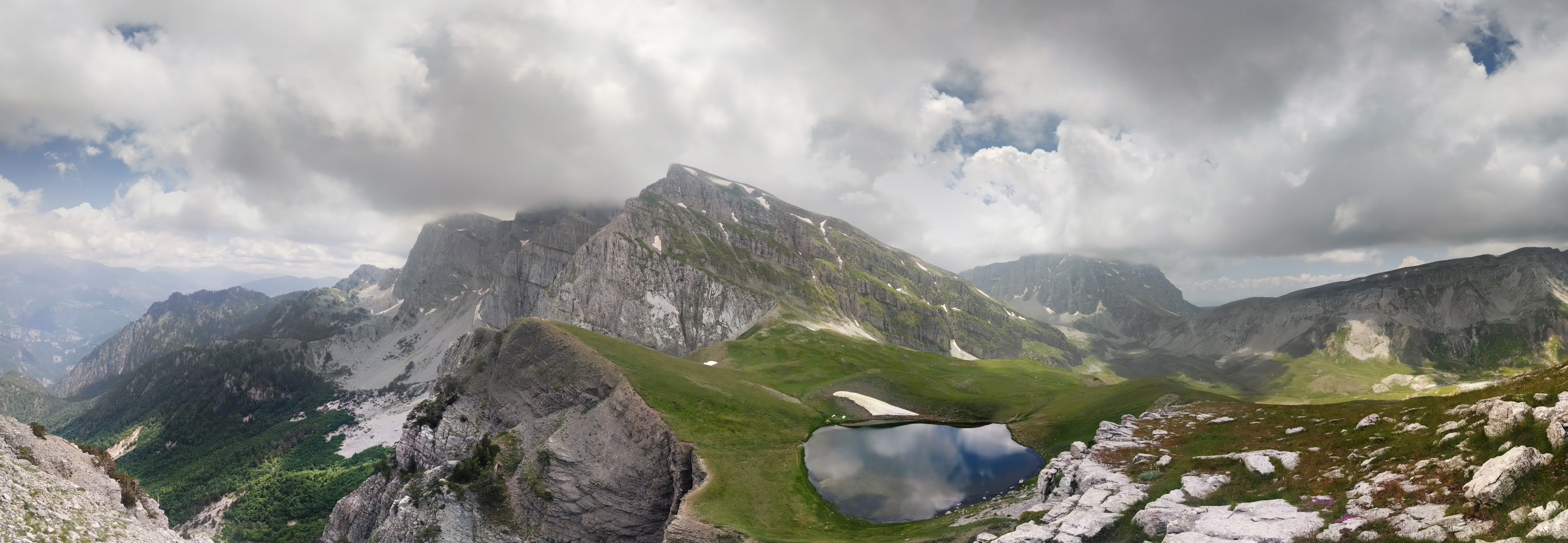
Mount Smolikas ( el, Σμόλικας; rup, Smolcu) is a mountain in the Ioannina regional unit, northwestern Greece. At a height of 2,637 metres above sea level, it is the highest of the Pindus Mountains, and the second highest mountain in Greece after Mount Olympus. The mountain consists of ophiolite rocks. During several periods in the Pleistocene the northern and eastern cirques and valleys were glaciated. The last glaciers of this area retreated around 11,500 years ago. It is drained by the river Vjosa to the south, and the river Vourkopotamo (a tributary of the Sarantaporos) to the north. There is a small alpine lake called "Drakolimni Smolika" near the summit, at about 2,200 metres elevation. Nearby mountain ranges are Tymfi to the south, Gramos to the northwest, Vasilitsa to the southeast and Voio to the northeast. The higher elevations, above 2,000 metres, consist of grasslands and rocks, and there are deciduous and conifer forests at lower elevations. The mountain li ... [...More Info...] [...Related Items...] OR: [Wikipedia] [Google] [Baidu] |
Mount Grammos
Gramos ( sq, Gramoz, Mali i Gramozit; rup, Gramosta, Gramusta; el, Γράμος or Γράμμος) is a mountain range on the border of Albania and Greece. The mountain is part of the northern Pindus mountain range. Its highest peak, at the border of Albania and Greece, is . The region is inhabited by Albanians, Aromanians and Greeks. The brown bear occurs in the region. Geography The Gramos is situated on the borders of the Kolonjë district of Albania and the Ioannina and Kastoria regional units of Greece. Three ridges join at its highest peak, running towards the north, southwest, and east. The Gramos is drained towards the west by the river Osum, towards the northwest by the Devoll, towards the northeast by the Aliakmonas and towards the south by the Sarantaporos. The Gramos is very sparsely populated, the only sizable town being Ersekë (Albania) at its western foot. Other villages in the mountains are Gramos (northeast), Aetomilitsa (southeast), Starje (west) and ... [...More Info...] [...Related Items...] OR: [Wikipedia] [Google] [Baidu] |
Aoös
The Vjosa (; indefinite form: ) or Aoös ( el, Αώος) is a river in northwestern Greece and southwestern Albania. Its total length is about , of which the first are in Greece, and the remaining in Albania. Its drainage basin is and its average discharge is . The main tributaries are Voidomatis, Sarantaporos, Drino and Shushicë. The river arises in the Pindus mountains of Epirus, Greece, and generally flows northwest. It enters Albania near Çarshovë, and empties into the Adriatic Sea just north of Vlorë. Generally wild and unpolluted, the river is surrounded by the Vikos–Aoös National Park in Greece and the Vjosa-Narta Protected Landscape near its mouth. In December 2020, the Albanian portion of the river was designated a "Managed Nature Reserve" by the government. There is a campaign by the environmentalist groups to designate the whole Albanian part of the course a national park, to guard against the prospective hydroelectric projects. Name The Vjosa is known b ... [...More Info...] [...Related Items...] OR: [Wikipedia] [Google] [Baidu] |
Aspropotamos, Trikala
Aspropotamos (Greek: Ασπροπόταμος meaning the white river) is a former community in the Trikala regional unit, Thessaly, Greece. Since the 2011 local government reform it is part of the municipality Meteora, of which it is a municipal unit. The 2011 census recorded 419 residents in the municipal unit. The seat of the community was in Kallirroi (pop. 42). Name The community was named after the river Aspropotamos, a tributary of the Acheloos. Geography Aspropotamos is located in the southern Pindus mountains, in the westernmost part of Trikala regional unit, about 40 km west of Trikala and 20 km southeast of Metsovo. Aspropotamos covers an area of 297.082 km2. The largest settlement in the municipal unit is Agía Paraskeví (pop. 69). Subdivisions The municipal unit Aspropotamos is subdivided into the following communities (constituent villages in brackets): *Agia Paraskevi * Anthousa * Chaliki * Kallirroi * Katafyto (Katafyto, Milia) * Krania (Krania ... [...More Info...] [...Related Items...] OR: [Wikipedia] [Google] [Baidu] |


