|
Lakmos
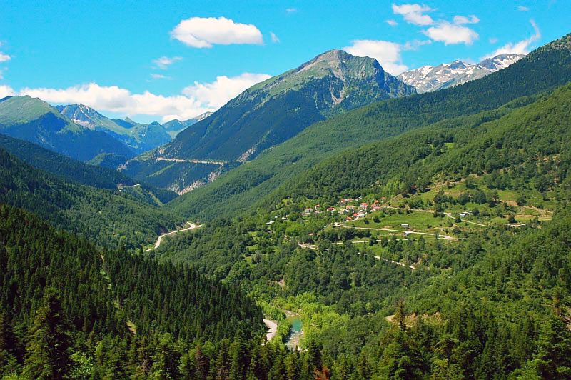
Lakmos ( el, Λάκμος) is a mountain in eastern Ioannina and western Trikala regional units. The mountain is a part of the Pindus mountain range. Its highest peak is the ''Peristeri'', at 2,295 m elevation. It stretches from the village Krapsi in the west to near Metsovo in the east, over a length of about . The nearest mountains are the Athamanika to the south, the Lygkos to the north and the Mitsikeli to the west. It is drained by the river Arachthos and its tributaries to the north, west and south, and by the Acheloos to the east. The nearest town is Metsovo, at its northeastern end. Other places in the mountains are Anthousa in the southeast, Anthochori in the north, Megali Gotista in the west and Vathypedo in the southwest. The Egnatia Odos motorway (Igoumenitsa - Ioannina - Kozani - Thessaloniki - Alexandroupoli Alexandroupolis ( el, Αλεξανδρούπολη, ), Alexandroupoli, or Alexandrople is a city in Greece and the capital of the Evros regional unit. It ... [...More Info...] [...Related Items...] OR: [Wikipedia] [Google] [Baidu] |
Pindus
The Pindus (also Pindos or Pindhos; el, Πίνδος, Píndos; sq, Pindet; rup, Pindu) is a mountain range located in Northern Greece and Southern Albania. It is roughly 160 km (100 miles) long, with a maximum elevation of 2,637 metres (8652') (Mount Smolikas). Because it runs along the border of Thessaly and Epirus, the Pindus range is known colloquially as the ''spine of Greece''. The mountain range stretches from near the Greek-Albanian border in southern Albania, entering the Epirus and Macedonia regions in northern Greece down to the north of the Peloponnese. Geologically it is an extension of the Dinaric Alps, which dominate the western region of the Balkan Peninsula. History of the name Historically, the name Pindos refers to the mountainous territory that separates the greater Epirus region from the regions of Macedonia and Thessaly. According to John Tzetzes (a 12th-century Byzantine writer), the Pindos range was then called Metzovon. When translated (bet ... [...More Info...] [...Related Items...] OR: [Wikipedia] [Google] [Baidu] |
List Of Mountains In Greece ...
A list of mountains in Greece: See also * Mount Kythnos *Movri *Omplos * Pantokrator (Corfu) *Skollis External linksMaps of mountains in Greeceby Geopsis {{List of mountains in Europe Greece * Mountains Greece Greece,, or , romanized: ', officially the Hellenic Republic, is a country in Southeast Europe. It is situated on the southern tip of the Balkans, and is located at the crossroads of Europe, Asia, and Africa. Greece shares land borders with ... [...More Info...] [...Related Items...] OR: [Wikipedia] [Google] [Baidu] |
Ioannina (regional Unit)
Ioannina ( el, Περιφερειακή ενότητα Ιωαννίνων) is one of the regional units of Greece. It is part of the region of Epirus. Its capital is the city of Ioannina. It is the largest regional unit in Epirus, and one of the largest regional units of Greece, with a population of 167,901 people, according to the 2011 census.GOV. results of permanent population 2011, p. 10561 (p. 87 of pdf), and in Excel formatTable of permanent population 2011 from the sitHellenic Statistical Authority 2017-11-24. Retrieved 2018-01-09. Geography Ioannina borders in the north, and the regional units of |
Lygkos
''Lyngos''( el, Λύγκος), also transliterated as ''Lygos'', is a remote mountain range in the eastern Ioannina and the western Grevena regional unit in northwestern Greece. It is a part of the Pindus mountain range. Its highest point is the Avgo, at 2,177 m elevation. The Lyngos mountains lie in a horseshoe shape around the Valia Kalda (Βάλια Κάλντα) valley, which exits towards the Aoos valley to the west. The Valia Kalda is part of the Pindus-Valia Kalda National Park, founded in 1966. It is one of the coldest and wettest regions of Greece. The mountains are densely forested, with alpine m ... [...More Info...] [...Related Items...] OR: [Wikipedia] [Google] [Baidu] |
Mitsikeli
Mitsikeli ( el, Μιτσικέλι) is a mountain range in the central part of the Pindus mountains, in Epirus, Greece. The mountain is located northeast of Ioannina and Lake Ioannina. Its highest elevation is . It stretches from near Kalpaki in the northwest to the eastern end of Lake Ioannina, a total length of . The northeastern slopes and the lower northwestern part of Mitsikeli are forested. The nearest mountains are the Tymfi to the north, the Lygkos to the northeast and the Lakmos to the east. It is drained by tributaries of the Thyamis to the northwest, towards Lake Ioannina to the southwest, by the Voidomatis (tributary of the Aoos) to the northeast and by the Arachthos to the southeast. Mitsikeli forms the southwestern border of the Zagori region. Villages in the mountains include Kato Pedina and Asprangeloi in the northwest, Dikorfo and Perivleptos in the central part, and Kryovrysi in the southeast. The Greek National Road 6 (Larissa - Trikala - Ioannina - Igoumenit ... [...More Info...] [...Related Items...] OR: [Wikipedia] [Google] [Baidu] |
Achelous River
The Achelous ( el, Αχελώος, grc, Ἀχελῷος ''Akhelôios''), also Acheloos, is a river in western Greece. It is long. It formed the boundary between Acarnania and Aetolia of antiquity. It empties into the Ionian Sea. In ancient times its spirit was venerated as the river god Achelous. Herodotus, taking notice of the shoreline-transforming power of the Acheloos River, even compared it to the Nile in this respect: :'There are other rivers as well which, though not as large as the Nile, have had substantial results. In particular (although I could name others), there is the Achelous, which flows through Acarnania into the sea and has already turned half the Echinades islands into mainland.' (2.10, trans. Waterfield) It is said to have been called more anciently ''Thoas'', ''Axenus'' and ''Thestius''. Course The river Achelous begins at about elevation on the eastern slope of Lakmos mountain in the Pindus range, near the village Anthousa in the westernmost part ... [...More Info...] [...Related Items...] OR: [Wikipedia] [Google] [Baidu] |
Igoumenitsa
Igoumenitsa ( el, Ηγουμενίτσα, ) is a coastal city in northwestern Greece. It is the capital of the regional unit of Thesprotia. Igoumenitsa is the chief port of Thesprotia and Epirus, and one of the largest passenger ports of Greece, connecting northwestern Mainland Greece with the Ionian Islands and Italy. The city is built on easternmost end of the Gulf of Igoumenitsa in the Ionian Sea and primary aspects of the economy are maritime, transport, services, agriculture and tourism. The long Egnatia Highway, which serves northern Greece, terminates at Igoumenitsa, making it a popular starting point for tourists coming from Europe and ending point for trucks from Turkey. Igoumenitsa features many shops, schools, offices and cargo storages, a university department, a library, an archeological museum, several sport stadiums and tennis courses, a courthouse and a medical clinic. The Thesprotia Police Headquarters and the Municipal Sailing Club are located here. The city ... [...More Info...] [...Related Items...] OR: [Wikipedia] [Google] [Baidu] |
Mountains Of Epirus (region)
A mountain is an elevated portion of the Earth's crust, generally with steep sides that show significant exposed bedrock. Although definitions vary, a mountain may differ from a plateau in having a limited summit area, and is usually higher than a hill, typically rising at least 300 metres (1,000 feet) above the surrounding land. A few mountains are isolated summits, but most occur in mountain ranges. Mountains are formed through tectonic forces, erosion, or volcanism, which act on time scales of up to tens of millions of years. Once mountain building ceases, mountains are slowly leveled through the action of weathering, through slumping and other forms of mass wasting, as well as through erosion by rivers and glaciers. High elevations on mountains produce colder climates than at sea level at similar latitude. These colder climates strongly affect the ecosystems of mountains: different elevations have different plants and animals. Because of the less hospitable terrain and ... [...More Info...] [...Related Items...] OR: [Wikipedia] [Google] [Baidu] |
Two-thousanders Of Greece
Two-thousanders are mountains that have a height of at least 2,000 metres above sea level, but less than 3,000 metres. The term is used in Alpine circles, especially in Europe (e.g. German: ''Zweitausender''). The two photographs show two typical two-thousanders in the Alps that illustrate different types of mountain. The Säuling (top) is a prominent, individual peak, whereas the Schneeberg (bottom) is an elongated limestone massif. In ranges like the Allgäu Alps, the Gesäuse or the Styrian-Lower Austrian Limestone Alps the mountain tour descriptions for mountaineers or hikers commonly include the two-thousanders, especially in areas where only a few summits exceed this level. Examples from these regions of the Eastern Alps are: * the striking Nebelhorn (2,224 m) near Oberstdorf or the Säuling (2,047 m) near Neuschwanstein, * the Admonter Reichenstein (2,251 m), Eisenerzer Reichenstein (2,165 m), Großer Pyhrgas (2,244 m) or Hochtor (2,369&nb ... [...More Info...] [...Related Items...] OR: [Wikipedia] [Google] [Baidu] |
Landforms Of Trikala (regional Unit)
A landform is a natural or anthropogenic land feature on the solid surface of the Earth or other planetary body. Landforms together make up a given terrain, and their arrangement in the landscape is known as topography. Landforms include hills, mountains, canyons, and valleys, as well as shoreline features such as bays, peninsulas, and seas, including submerged features such as mid-ocean ridges, volcanoes, and the great ocean basins. Physical characteristics Landforms are categorized by characteristic physical attributes such as elevation, slope, orientation, stratification, rock exposure and soil type. Gross physical features or landforms include intuitive elements such as berms, mounds, hills, ridges, cliffs, valleys, rivers, peninsulas, volcanoes, and numerous other structural and size-scaled (e.g. ponds vs. lakes, hills vs. mountains) elements including various kinds of inland and oceanic waterbodies and sub-surface features. Mountains, hills, plateaux, and plains are the fou ... [...More Info...] [...Related Items...] OR: [Wikipedia] [Google] [Baidu] |
Landforms Of Ioannina (regional Unit)
A landform is a natural or anthropogenic land feature on the solid surface of the Earth or other planetary body. Landforms together make up a given terrain, and their arrangement in the landscape is known as topography. Landforms include hills, mountains, canyons, and valleys, as well as shoreline features such as bays, peninsulas, and seas, including submerged features such as mid-ocean ridges, volcanoes, and the great ocean basins. Physical characteristics Landforms are categorized by characteristic physical attributes such as elevation, slope, orientation, stratification, rock exposure and soil type. Gross physical features or landforms include intuitive elements such as berms, mounds, hills, ridges, cliffs, valleys, rivers, peninsulas, volcanoes, and numerous other structural and size-scaled (e.g. ponds vs. lakes, hills vs. mountains) elements including various kinds of inland and oceanic waterbodies and sub-surface features. Mountains, hills, plateaux, and plains are the fo ... [...More Info...] [...Related Items...] OR: [Wikipedia] [Google] [Baidu] |
Alexandroupoli
Alexandroupolis ( el, Αλεξανδρούπολη, ), Alexandroupoli, or Alexandrople is a city in Greece and the capital of the Evros regional unit. It is the largest city in Western Thrace and the region of Eastern Macedonia and Thrace. It has 71,601 inhabitants and is an important port and commercial center of northeastern Greece. The city was first settled by the Ottoman Empire in the 19th century and grew into a fishing village, Dedeağaç. In 1873, it became a ''kaza'' and one year later, it was promoted to a ''sanjak''. The city developed into a regional trading center. Later, it became a part of Adrianople Vilayet. During the Russo-Turkish War (1877–1878), it was briefly captured by the Russians. Ottoman rule ended with the First Balkan War, when the city was captured by Bulgaria in 1912. In the Second Balkan War, Greece took the control of the city. With the Treaty of Bucharest (10 August 1913), the city returned back to Bulgaria. With the defeat of Bulgaria in Wor ... [...More Info...] [...Related Items...] OR: [Wikipedia] [Google] [Baidu] |


.jpg)
