|
NEEM Camp
NEEM Camp was a small research facility on the northern Greenland Ice Sheet, used as a base for ice core drilling. It was located about 313 km east of the closest coast, Peabody Bay in northern Greenland, 275 km northwest of the historical ice sheet camp North Ice, and 484 km east-northeast of Siorapaluk, the closest settlement. There was one heavy-duty tent for accommodation of the researchers during summer. Access was by skiway (snow runway). The acronym NEEM stands for North Greenland Eemian Ice Drilling. The ice at the NEEM coring location (77°27'N 51°3.6'W) was predicted to be 2545 m thick. Drilling started at NEEM in June 2009 and drillers expected to hit bedrock in 2010. The drilling progressed well and reached through the brittle zone (~800 m) in mid-July 2009. The plan was to process the ice below the brittle zone, per decision at the steering committee meeting in November 2008 in Copenhagen. By September 1, 2009, the coring had reached 1757.84 m for ... [...More Info...] [...Related Items...] OR: [Wikipedia] [Google] [Baidu] |
Greenland Ice Sheet
The Greenland ice sheet ( da, Grønlands indlandsis, kl, Sermersuaq) is a vast body of ice covering , roughly near 80% of the surface of Greenland. It is sometimes referred to as an ice cap, or under the term ''inland ice'', or its Danish equivalent, ''indlandsis''. An acronym, GIS, is frequently used in the scientific literature. It is the second largest ice body in the world, after the Antarctic ice sheet. The ice sheet is almost long in a north–south direction, and its greatest width is at a latitude of 77°N, near its northern margin. The average thickness is about and over at its thickest point. In addition to the large ice sheet, smaller ice caps (such as Maniitsoq and Flade Isblink) as well as glaciers, cover between around the periphery. The Greenland ice sheet is adversely affected by climate change. It is more vulnerable to climate change than the Antarctic ice sheet because of its position in the Arctic, where it is subject to the regional amplification o ... [...More Info...] [...Related Items...] OR: [Wikipedia] [Google] [Baidu] |
Ice Core
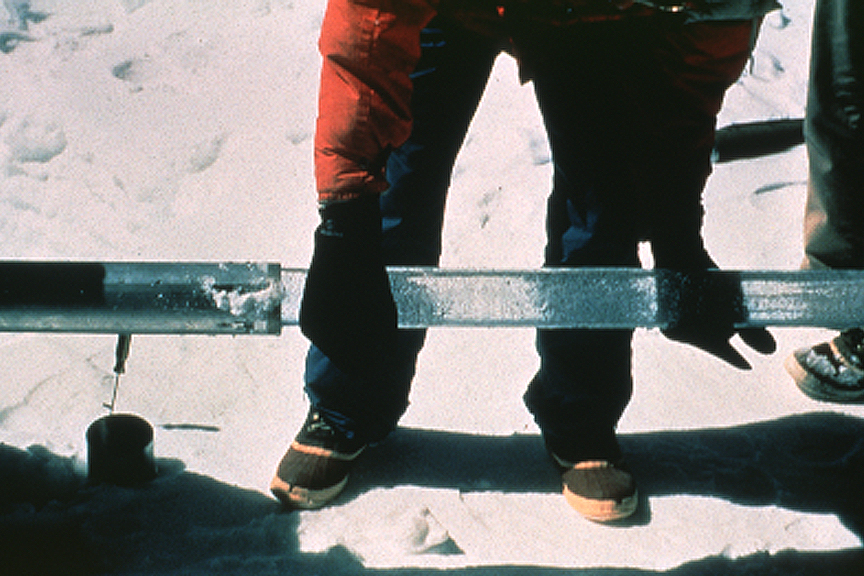
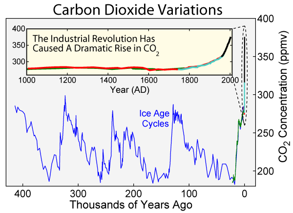
An ice core is a core sample that is typically removed from an ice sheet or a high mountain glacier. Since the ice forms from the incremental buildup of annual layers of snow, lower layers are older than upper ones, and an ice core contains ice formed over a range of years. Cores are drilled with hand augers (for shallow holes) or powered drills; they can reach depths of over two miles (3.2 km), and contain ice up to 800,000 years old. The physical properties of the ice and of material trapped in it can be used to reconstruct the climate over the age range of the core. The proportions of different oxygen and hydrogen isotopes provide information about ancient temperatures, and the air trapped in tiny bubbles can be analysed to determine the level of atmospheric gases such as carbon dioxide. Since heat flow in a large ice sheet is very slow, the borehole temperature is another indicator of temperature in the past. These data can be combined to find the climate model ... [...More Info...] [...Related Items...] OR: [Wikipedia] [Google] [Baidu] |
Peabody Bay
Peabody Bay ( da, Peabody Bugt) is a large bay in northwestern Greenland. Administratively it is part of Avannaata municipality. Geography Peabody Bay is located on the eastern side of the Kane Basin off the western end of the Humboldt Glacier. Cape Forbes and the Cass Fjord lie at the northern end of the roughly 80 km wide bay. The McGary Islands lie at the southern end of the bay and the Bonsall Islands lie between that end and Dallas Bay to the SW. Elisha Kane —whose Arctic venture in search of the lost Franklin expedition crossed the area in 1854— had named the Kane Basin itself "Peabody Bay," in honor of philanthropist George Peabody George Peabody ( ; February 18, 1795 – November 4, 1869) was an American financier and philanthropist. He is widely regarded as the father of modern philanthropy. Born into a poor family in Massachusetts, Peabody went into business in dry go ..., the major funder of Kane's expedition. Currently, however, Peabody Bay is this smaller ... [...More Info...] [...Related Items...] OR: [Wikipedia] [Google] [Baidu] |
Greenland
Greenland ( kl, Kalaallit Nunaat, ; da, Grønland, ) is an island country in North America that is part of the Kingdom of Denmark. It is located between the Arctic and Atlantic oceans, east of the Canadian Arctic Archipelago. Greenland is the world's largest island. It is one of three constituent countries that form the Kingdom of Denmark, along with Denmark and the Faroe Islands; the citizens of these countries are all citizens of Denmark and the European Union. Greenland's capital is Nuuk. Though a part of the continent of North America, Greenland has been politically and culturally associated with Europe (specifically Norway and Denmark, the colonial powers) for more than a millennium, beginning in 986.The Fate of Greenland's Vikings , by Dale Mackenzie Brown, ''Archaeological Institute of America'', ... [...More Info...] [...Related Items...] OR: [Wikipedia] [Google] [Baidu] |
North Ice
North Ice was a research station of the British North Greenland Expedition (1952 to 1954) on the inland ice of Greenland. The coordinates of the station were , at an altitude of above sea level. The British North Greenland Expedition was led by Commander James Simpson RN. The station recorded a temperature of on 9 January 1954, which made it the lowest temperature ever recorded in North America up until that time. It was superseded by an observation of at the Greenland Ice Sheet on 22 December 1991. The name of the station contrasts to the former British South Ice station in Antarctica. See also *List of research stations in the Arctic *Eismitte *Summit Camp *NEEM Camp NEEM Camp was a small research facility on the northern Greenland Ice Sheet, used as a base for ice core drilling. It was located about 313 km east of the closest coast, Peabody Bay in northern Greenland, 275 km northwest of the histor ... References Research stations in Greenland Arctic ... [...More Info...] [...Related Items...] OR: [Wikipedia] [Google] [Baidu] |
Siorapaluk
Siorapaluk (West Greenlandic) or Hiurapaluk ( Polar Inuit) is a settlement in the Qaanaaq area of the Avannaata municipality in northern Greenland. It is one of the world's northernmost inhabited settlements, the northernmost settlement inhabited by natives, and the northernmost public settlement in Greenland. It has a population of 43 who speak the Inuktun language of the Polar Inuit as well as the Kalaallisut dialect of Greenlandic. Many of the inhabitants are direct descendants of the last migration of Inuit from Canada in the 20th century. Geography Siorapaluk is located in the northern shore of the Siorapaluup Kangerlua (Robertson Fjord). Hunting There is good hunting in the area of the settlement, and the cliffs around it function as breeding grounds for dovekie (UK English: little auk) ('' Alle alle'') and the thick-billed murre (UK English: Brünnich's guillemot) (''Uria lomvia''). There are many Arctic foxes and Arctic hares in the area and an abundance of seals and walr ... [...More Info...] [...Related Items...] OR: [Wikipedia] [Google] [Baidu] |
Acronym
An acronym is a word or name formed from the initial components of a longer name or phrase. Acronyms are usually formed from the initial letters of words, as in ''NATO'' (''North Atlantic Treaty Organization''), but sometimes use syllables, as in ''Benelux'' (short for ''Belgium, the Netherlands, and Luxembourg''). They can also be a mixture, as in ''radar'' (''Radio Detection And Ranging''). Acronyms can be pronounced as words, like ''NASA'' and ''UNESCO''; as individual letters, like ''FBI'', ''TNT'', and ''ATM''; or as both letters and words, like '' JPEG'' (pronounced ') and ''IUPAC''. Some are not universally pronounced one way or the other and it depends on the speaker's preference or the context in which it is being used, such as '' SQL'' (either "sequel" or "ess-cue-el"). The broader sense of ''acronym''—the meaning of which includes terms pronounced as letters—is sometimes criticized, but it is the term's original meaning and is in common use. Dictionary and st ... [...More Info...] [...Related Items...] OR: [Wikipedia] [Google] [Baidu] |
Eemian Stage
The Eemian (also called the last interglacial, Sangamonian Stage, Ipswichian, Mikulin, Kaydaky, penultimate,NOAA - Penultimate Interglacial Period http://www.ncdc.noaa.gov/global-warming/penultimate-interglacial-period Valdivia or Riss-Würm) was the interglacial period which began about 130,000 years ago at the end of the Penultimate Glacial Period and ended about 115,000 years ago at the beginning of the Last Glacial Period. It corresponds to Marine Isotope Stage 5e. Although sometimes referred to as the "last interglacial" (in the "most recent previous" sense of "last"), it was the second-to-latest interglacial period of the current Ice Age, the most recent being the Holocene which extends to the present day (having followed the last glacial period). The prevailing Eemian climate was, on average, around 1 to 2 degrees Celsius (1.8 to 3.6 Fahrenheit) warmer than that of the Holocene. During the Eemian, the proportion of in the atmosphere was about 280 parts per million. The ... [...More Info...] [...Related Items...] OR: [Wikipedia] [Google] [Baidu] |
East Greenland Ice-Core Project
The East Greenland Ice-Core Project, known as EGRIP, is a scientific project that plans to retrieve an ice core from the Northeast Greenland ice stream. The first season in the field was 2015; the project was expected to be drilling through to the base of the ice sheet by 2020. Much of the camp set up for the North Greenland Eemian Ice Drilling Project (NEEM) was moved to the EGRIP location in 2015. The equipment was towed by several tractors. The team ran low on fuel and had to abandon some equipment, arriving at the EGRIP location on 26 May, after nine days of towing. In March 2020, the 2020 EGRIP field campaign was cancelled due to the ongoing COVID-19 pandemic The COVID-19 pandemic, also known as the coronavirus pandemic, is an ongoing global pandemic of coronavirus disease 2019 (COVID-19) caused by severe acute respiratory syndrome coronavirus 2 (SARS-CoV-2). The novel virus was first identif .... The 2021 field season was also cancelled. EastGRIP reopened for ... [...More Info...] [...Related Items...] OR: [Wikipedia] [Google] [Baidu] |
List Of Research Stations In The Arctic
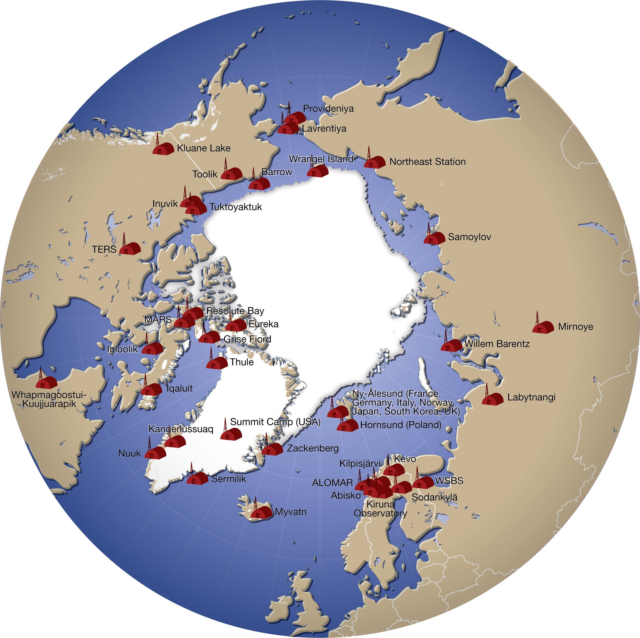
A number of governments maintain permanent research stations in the Arctic. Also known as Arctic bases, polar stations or ice stations, these bases are widely distributed across the northern polar region of Earth. Historically few research stations have been permanent. Most of them were temporary, being abandoned after the completion of the project or owing to lack of funding to continue the research. Some of these were military or intelligence stations (listening posts) created as a result of the proximity of the U.S. and Soviet Union to each other's landmass across the polar region. Ice stations are constructed on land or on ice that rests on land, while others are drifting ice stations built on the sea ice of the high latitudes of the Arctic Ocean. Research stations Drifting ice stations *Fletcher's Ice Island, US (1952 - 1978) In fiction *Ice Station Zebra (novel), by Alistair MacLean **Ice Station Zebra (1968 film) **Ice Station Zebra a song by Jack White on Boar ... [...More Info...] [...Related Items...] OR: [Wikipedia] [Google] [Baidu] |


