|
Moreas Motorway
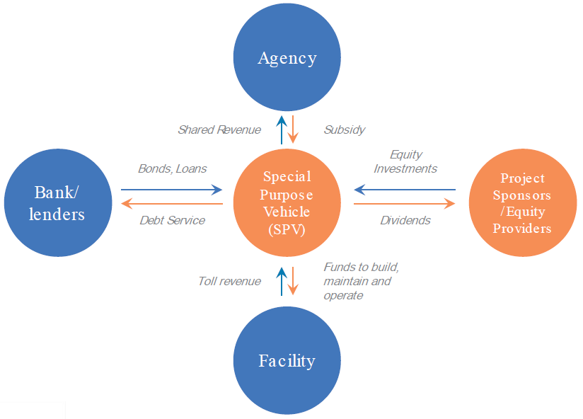
The Moreas Motorway ( el, Αυτοκινητόδρομος Μωρέας, designated: A7) is a motorway in Peloponnese, Greece. The A7 begins just west of the Isthmus of Corinth, branching off from Greek National Road 8A (which is now integrated into the Olympia Odos). It connects Corinth and Kalamata via Tripoli. As part of the concession agreement between the Greek state and the consortium operating the motorway (Moreas S.A.), the latter is responsible for constructing, operating, maintaining and modernizing the A7. In existing sections of the motorway, improvements include the straightening of dangerous curves, constructing new tunnels, completing the Artemision tunnel, adding more light fixtures and upgrading the median throughou Length * Corinth to Tripoli: 74 km (46 mi) * Corinth to Kalamata: 147 km (91 mi) *Lefktro to Sparta: 45,5 km (28 mi) *Total length: 205 km (127 mi) History and additional information The Corinth-Tripo ... [...More Info...] [...Related Items...] OR: [Wikipedia] [Google] [Baidu] |
Corinth
Corinth ( ; el, Κόρινθος, Kórinthos, ) is the successor to an ancient city, and is a former municipality in Corinthia, Peloponnese (region), Peloponnese, which is located in south-central Greece. Since the 2011 local government reform, it has been part of the Corinth (municipality), municipality of Corinth, of which it is the seat and a municipal unit. It is the capital of Corinthia. It was founded as Nea Korinthos (), or New Corinth, in 1858 after an earthquake destroyed the existing settlement of Corinth, which had developed in and around the site of ancient Corinth. Geography Located about west of Athens, Corinth is surrounded by the coastal townlets of (clockwise) Lechaio, Isthmia, Corinthia, Isthmia, Kechries, and the inland townlets of Examilia and the archaeological site and village of ancient Corinth. Natural features around the city include the narrow coastal plain of Vocha (plain of), Vocha, the Gulf of Corinth, Corinthian Gulf, the Isthmus of Corinth ... [...More Info...] [...Related Items...] OR: [Wikipedia] [Google] [Baidu] |
Sparta
Sparta ( Doric Greek: Σπάρτα, ''Spártā''; Attic Greek: Σπάρτη, ''Spártē'') was a prominent city-state in Laconia, in ancient Greece. In antiquity, the city-state was known as Lacedaemon (, ), while the name Sparta referred to its main settlement on the banks of the Eurotas River in Laconia, in south-eastern Peloponnese. Around 650 BC, it rose to become the dominant military land-power in ancient Greece. Given its military pre-eminence, Sparta was recognized as the leading force of the unified Greek military during the Greco-Persian Wars, in rivalry with the rising naval power of Athens. Sparta was the principal enemy of Athens during the Peloponnesian War (431–404 BC), from which it emerged victorious after the Battle of Aegospotami. The decisive Battle of Leuctra in 371 BC ended the Spartan hegemony, although the city-state maintained its political independence until its forced integration into the Achaean League in 192 BC. The city nevertheles ... [...More Info...] [...Related Items...] OR: [Wikipedia] [Google] [Baidu] |
Myloi, Argolis
Myloi ( el, Μύλοι), is a village in the southwestern part of Argolis, Greece. Myloi was the seat of the former municipality of Lerna. It is 4 km southwest of Nea Kios, 9 km south of Argos and 8 km west of Nafplio. The Greek National Road 7 passes through the village. It had a train station on the Corinth–Kalamata railway, but passenger service on this line was halted in 2010. Situated on the northwestern coast of the Argolic Gulf, Myloi is a popular fishing village and local tourist destination for its beaches and restaurants, hotels, market, and bakery open for most of the year. Sites Lerna Lerna is a Bronze Age The Bronze Age is a historic period, lasting approximately from 3300 BC to 1200 BC, characterized by the use of bronze, the presence of writing in some areas, and other early features of urban civilization. The Bronze Age is the second pri ... settlement site located in Myloi that was occupied from the Neolithic to the Mycenean period (6th - 1st ... [...More Info...] [...Related Items...] OR: [Wikipedia] [Google] [Baidu] |
Achladokampos
Achladokampos ( el, Αχλαδόκαμπος) is a village and a former community in Argolis, Peloponnese, Greece. Since the 2011 local government reform it is part of the municipality Argos-Mykines, of which it is a municipal unit. The municipal unit has an area of 105.883 km2. Population 497 (2011). It is located on a mountainside approximately midway between Argos Argos most often refers to: * Argos, Peloponnese, a city in Argolis, Greece ** Ancient Argos, the ancient city * Argos (retailer), a catalogue retailer operating in the United Kingdom and Ireland Argos or ARGOS may also refer to: Businesses ... and Tripoli (~30 km from each) at an elevation of approximately 450 meters. A significant number of emigrants from Achladokampos have settled in the United States since the early 20th century and have formed thBrotherhood of Achladokambitonas a means of keeping in touch. References External links Populated places in Argolis {{Peloponnese-geo-s ... [...More Info...] [...Related Items...] OR: [Wikipedia] [Google] [Baidu] |
Argos, Peloponnese
Argos (; el, Άργος ; grc, label=Ancient and Katharevousa, Ἄργος ) is a city in Argolis, Peloponnese, Greece and is one of the oldest continuously inhabited cities in the world, and the oldest in Europe. It is the largest city in Argolis and a major center for the area. Since the 2011 local government reform it has been part of the municipality of Argos-Mykines, of which it is a municipal unit. The municipal unit has an area of 138.138 km2. It is from Nafplion, which was its historic harbour. A settlement of great antiquity, Argos has been continuously inhabited as at least a substantial village for the past 7,000 years. A resident of the city of Argos is known as an Argive ( , ; grc-gre, Ἀργεῖος). However, this term is also used to refer to those ancient Greeks generally who assaulted the city of Troy during the Trojan War; the term is more widely applied by the Homeric bards. Numerous ancient monuments can be found in the city today. Agricul ... [...More Info...] [...Related Items...] OR: [Wikipedia] [Google] [Baidu] |
Dervenakia
Dervenakia ( el, Δερβενάκια) is a small village in Corinthia, in northeastern Peloponnese (southern Greece). It is situated on the old national highway from Nafplio to Corinth. Dervenakia is part of the community of Archaia Nemea. The name is derived from the Turkish word ''derven'', meaning mountain pass. The place is famous for the Battle of Dervenakia, fought on 26–28 July 1822 during the Greek War of Independence, where 2,300 Greek irregulars under Theodoros Kolokotronis defeated the 30,000-strong army of Ottoman general Mahmud Dramali Pasha Dramalı Mahmud Pasha, ( Turkish: ''Dramalı Mahmut Paşa''; c. 1770 in Istanbul – 26 October 1822, in Corinth) was an Ottoman Albanian statesman and military leader, and a pasha, and served as governor (''wali'') of Larissa, Drama, and the M .... Populated places in Corinthia {{Peloponnese-geo-stub ... [...More Info...] [...Related Items...] OR: [Wikipedia] [Google] [Baidu] |
Nemea
Nemea (; grc, Νεμέα; grc-x-ionic, Νεμέη) is an ancient site in the northeastern part of the Peloponnese, in Greece. Formerly part of the territory of Cleonae in ancient Argolis, it is today situated in the regional unit of Corinthia. The small village of Archaia Nemea (formerly known as "Iraklion") is immediately southwest of the archaeological site, while the new town of Nemea lies to the west. Here, in Greek mythology, Heracles overcame the Nemean Lion, and here, during Antiquity, the Nemean Games were held (ending c. 235 BC) and were celebrated in the eleven Nemean odes of Pindar. Myth, legend and history In Greek mythology, Nemea was ruled by king Lycurgus and queen Eurydice. Nemea was famous in Greek myth as the home of the Nemean Lion, which was killed by the hero Heracles,In the late 2nd century CE, the traveller Pausanias was shown the lion's cave, fifteen furlongs from the sanctuary (Pausanias, ''Description of Greece'', II.15.2–.4). and as the ... [...More Info...] [...Related Items...] OR: [Wikipedia] [Google] [Baidu] |
Greek National Road 7
Greek National Road 7 ( el, Εθνική Οδός 7, abbreviated as EO7) is a single carriageway with at-grade intersections in the Peloponnese region in southern Greece. It connects the cities of Corinth and Kalamata, via Nemea Nemea (; grc, Νεμέα; grc-x-ionic, Νεμέη) is an ancient site in the northeastern part of the Peloponnese, in Greece. Formerly part of the territory of Cleonae in ancient Argolis, it is today situated in the regional unit of Corinth ..., Argos, Tripoli and Megalopoli. It has been succeeded in importance by the Moreas Motorway (Corinth–Kalamata), which is numbered A7. 7 Roads in Peloponnese (region) {{greece-road-stub ... [...More Info...] [...Related Items...] OR: [Wikipedia] [Google] [Baidu] |
List Of Greek Roads
The National Roads and Motorways in Greece constitute the main road network of the country. These two types of roads are distinct in terms of their construction specifications. Their main difference is that motorways (Greek: Αυτοκινητόδρομοι) adhere to higher quality construction standards than National Roads (Greek: Εθνικές Οδοί). For example, a typical motorway (highway) in Greece consists of six or four lanes (three or two lanes in each direction) plus an emergency lane, separated by a central barrier. Entrances and exits to the motorways are only provided at grade-separated junctions (interchanges) and there are no traffic lights. Greek motorways are generally organized so that the odd-numbered motorways are of north-south alignment and the even-numbered motorways are of east-west alignment. However, there are many exceptions. A typical National Road in Greece is usually a single carriageway or limited-access road with at-grade intersections and w ... [...More Info...] [...Related Items...] OR: [Wikipedia] [Google] [Baidu] |
Kalamata
Kalamáta ( el, Καλαμάτα ) is the second most populous city of the Peloponnese peninsula, after Patras, in southern Greece and the largest city of the homonymous administrative region. As the capital and chief port of the Messenia regional unit, it lies along the Nedon River at the head of the Messenian Gulf. The 2011 census recorded 69,849 inhabitants for the wider Kalamata Municipality, of which, 62,409 resided in the municipal unit of Kalamata, and 54,567 in the city proper. Kalamata is renowned as the land of the Kalamatianos dance and Kalamata olives. Name The modern name ''Kalamáta'' is a corruption of the older name Καλάμαι, ''Kalámai'', " reeds". The phonetic similarity of ''Kalamáta'' with the phrase καλά μάτια "kalá mátia" ("good eyes") has led to various folk etymologies. Administration The municipality Kalamata was formed as part of the 2011 local government reform by the merger of the following four former municipalities, each of ... [...More Info...] [...Related Items...] OR: [Wikipedia] [Google] [Baidu] |
Concession (contract)
A concession or concession agreement is a grant of rights, land or property by a government, local authority, corporation, individual or other legal entity. Public services such as water supply may be operated as a concession. In the case of a public service concession, a private company enters into an agreement with the government to have the exclusive right to operate, maintain and carry out investment in a public utility (such as a water privatisation) for a given number of years. Other forms of contracts between public and private entities, namely lease contract and management contract (in the water sector often called by the French term ''affermage''), are closely related but differ from a concession in the rights of the operator and its remuneration. A lease gives a company the right to operate and maintain a public utility, but investment remains the responsibility of the public. Under a management contract the operator will collect the revenue only on behalf of the g ... [...More Info...] [...Related Items...] OR: [Wikipedia] [Google] [Baidu] |


