|
Myloi, Argolis
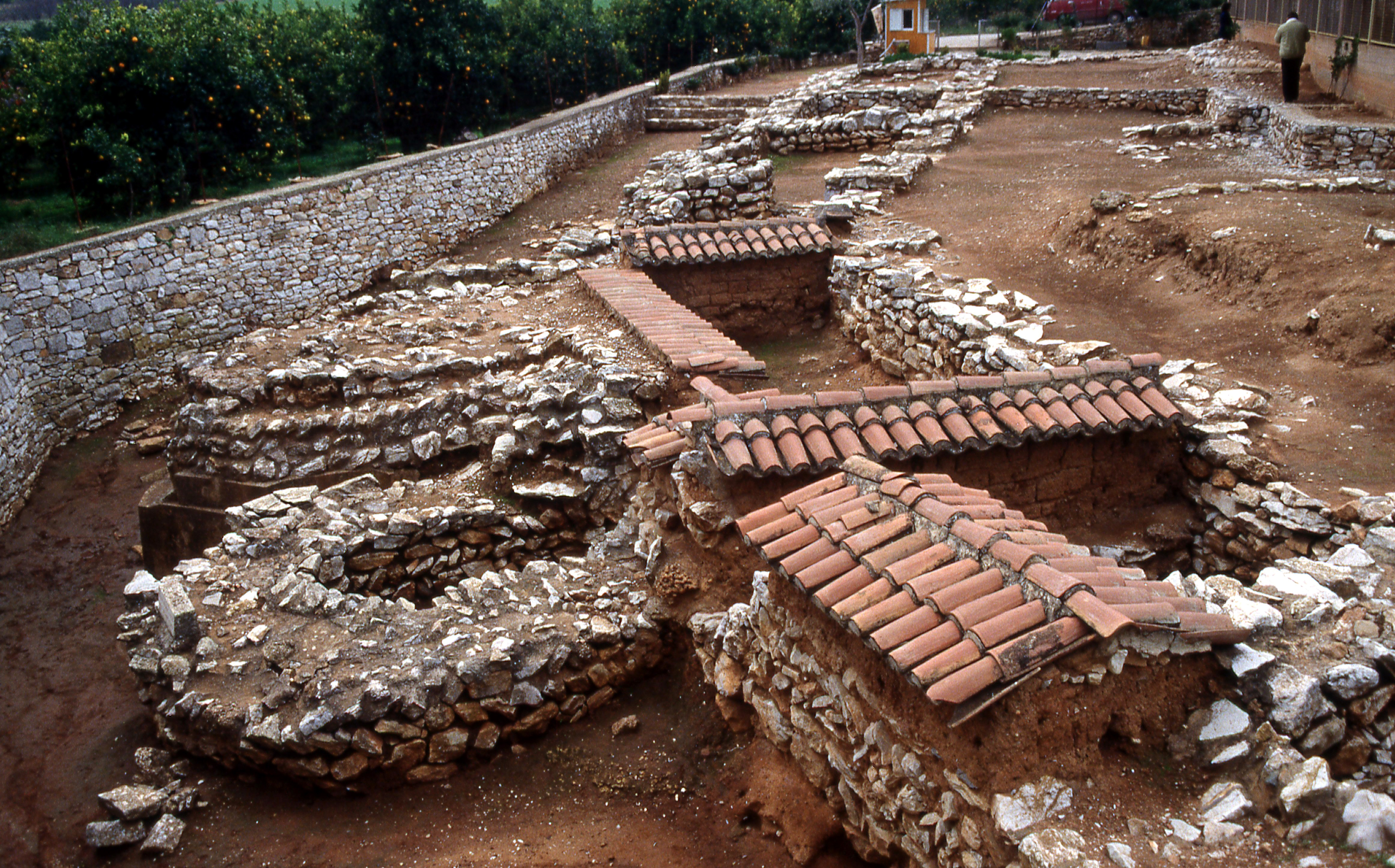
Myloi ( el, Μύλοι), is a village in the southwestern part of Argolis, Greece. Myloi was the seat of the former municipality of Lerna. It is 4 km southwest of Nea Kios, 9 km south of Argos and 8 km west of Nafplio. The Greek National Road 7 passes through the village. It had a train station on the Corinth–Kalamata railway, but passenger service on this line was halted in 2010. Situated on the northwestern coast of the Argolic Gulf, Myloi is a popular fishing village and local tourist destination for its beaches and restaurants, hotels, market, and bakery open for most of the year. Sites Lerna Lerna is a Bronze Age settlement site located in Myloi that was occupied from the Neolithic to the Mycenean period (6th - 1st century BC). Excavated by the American School of Classical Studies in Athens, several buildings were recovered with the most famous being the House of the Tiles, a large monumental building names after the remains of baked roofing tiles. The site is man ... [...More Info...] [...Related Items...] OR: [Wikipedia] [Google] [Baidu] |
Peloponnese (region)
The Peloponnese Region ( el, Περιφέρεια Πελοποννήσου, translit=Periféria Peloponnísou, ) is a Modern regions of Greece, region in southern Greece. It borders Western Greece to the north and Attica (region), Attica to the north-east. The region has an area of about . It covers most of the Peloponnese peninsula, except for the northwestern subregions of Achaea and Elis (regional unit), Elis which belong to Western Greece and a small portion of the Argolis, Argolid peninsula that is part of Attica (region), Attica. Administration The Peloponnese Region was established in the 1987 administrative reform. With the 2011 Kallikratis plan, its powers and authority were redefined and extended. Along with the Western Greece and Ionian Islands (region), Ionian Islands regions, it is supervised by the Decentralized Administration of Peloponnese, Western Greece and the Ionian, Decentralized Administration of Peloponnese, Western Greece and the Ionian Islands based at P ... [...More Info...] [...Related Items...] OR: [Wikipedia] [Google] [Baidu] |
Argolic Gulf
The Argolic Gulf (), also known as the Gulf of Argolis, is a gulf of the Aegean Sea off the east coast of the Peloponnese, Greece. It is about 50 km long and 30 km wide. Its main port is Nafplio, at its northwestern end. At the entrance to the gulf is the island Spetses. This gulf and its islands are sometimes combined with the Saronic Gulf and Saronic Islands, with the result called the Argo-Saronic Gulf and the Argo-Saronic Islands. It is surrounded by two regional units: Arcadia to the southwest and Argolis to the north and east. The river Inachos drains into the Argolic Gulf near Nea Kios. The main islands in the gulf are Psili, Plateia and Bourtzi, a small island with a Venetian fortress that protects the port of Nafplio. The surrounding mountains protect it from the strong summer Meltemi wind. The main towns that lie around the gulf are, from southwest to east: *Tyros * Paralio Astros * Myloi *Nea Kios *Nafplio * Tolo or Tolon, on Tolo Bay *Porto Cheli *Spetses G ... [...More Info...] [...Related Items...] OR: [Wikipedia] [Google] [Baidu] |
Ottoman–Venetian War (1463–1479)
The First Ottoman–Venetian War was fought between the Republic of Venice and her allies and the Ottoman Empire from 1463 to 1479. Fought shortly after the Fall of Constantinople, capture of Constantinople and the remnants of the Byzantine Empire by the Ottomans, it resulted in the loss of several Venetian holdings in Albania and Greece, most importantly the island of Negroponte (Euboea), which had been a Lordship of Negroponte, Venetian protectorate for centuries. The war also saw the rapid expansion of the Ottoman navy, which became able to challenge the Venetians and the Knights Hospitaller for supremacy in the Aegean Sea. In the closing years of the war, however, the Republic managed to recoup its losses by the ''de facto'' acquisition of the Crusader Kingdom of Cyprus. Background Following the Fourth Crusade (1203–1204), the lands of the Byzantine Empire were divided among several western Roman Catholic, Catholic ("Latins (Middle Ages), Latin") Crusader states, usherin ... [...More Info...] [...Related Items...] OR: [Wikipedia] [Google] [Baidu] |
Castle Of Kiveri 01
A castle is a type of fortified structure built during the Middle Ages predominantly by the nobility or royalty and by military orders. Scholars debate the scope of the word ''castle'', but usually consider it to be the private fortified residence of a lord or noble. This is distinct from a palace, which is not fortified; from a fortress, which was not always a residence for royalty or nobility; from a ''pleasance'' which was a walled-in residence for nobility, but not adequately fortified; and from a fortified settlement, which was a public defence – though there are many similarities among these types of construction. Use of the term has varied over time and has also been applied to structures such as hill forts and 19th-20th century homes built to resemble castles. Over the approximately 900 years when genuine castles were built, they took on a great many forms with many different features, although some, such as curtain walls, arrowslits, and portcullises, were ... [...More Info...] [...Related Items...] OR: [Wikipedia] [Google] [Baidu] |
American School Of Classical Studies At Athens
, native_name_lang = Greek , image = American School of Classical Studies at Athens.jpg , image_size = , image_alt = , caption = The ASCSA main building as seen from Mount Lykavittos , latin_name = , other_name = , former_name = , motto = , motto_lang = , mottoeng = , established = 1881 , closed = , type = Overseas Research Center / Higher Education , parent = , affiliation = , religious_affiliation = , academic_affiliation = , endowment = , budget = , officer_in_charge = , chairman = , chairperson = , chancellor = , president = , vice-president = , superintendent = , provost = , vice_chancellor = , rector = , principal = , dean = , director = , head_label = , head = , academic_staff = , administrative_staff = , students = , undergrad = , postgrad = , doctoral = , other = , city = Athens , state = , province = , country = Greece , coor = , campus = urban , language = , free_label = , fr ... [...More Info...] [...Related Items...] OR: [Wikipedia] [Google] [Baidu] |
Bronze Age
The Bronze Age is a historic period, lasting approximately from 3300 BC to 1200 BC, characterized by the use of bronze, the presence of writing in some areas, and other early features of urban civilization. The Bronze Age is the second principal period of the three-age system proposed in 1836 by Christian Jürgensen Thomsen for classifying and studying ancient societies and history. An ancient civilization is deemed to be part of the Bronze Age because it either produced bronze by smelting its own copper and alloying it with tin, arsenic, or other metals, or traded other items for bronze from production areas elsewhere. Bronze is harder and more durable than the other metals available at the time, allowing Bronze Age civilizations to gain a technological advantage. While terrestrial iron is naturally abundant, the higher temperature required for smelting, , in addition to the greater difficulty of working with the metal, placed it out of reach of common use until the end o ... [...More Info...] [...Related Items...] OR: [Wikipedia] [Google] [Baidu] |
Lerna
In classical Greece, Lerna ( el, Λέρνη) was a region of springs and a former lake near the east coast of the Peloponnesus, south of Argos. Even though much of the area is marshy, Lerna is located on a geographically narrow point between mountains and the sea, along an ancient route from the Argolid to the southern Peloponnese; this location may have resulted in the importance of the settlement. Its site near the village Mili at the Argolic Gulf is most famous as the lair of the Lernaean Hydra, the chthonic many-headed water snake, a creature of great antiquity when Heracles killed it, as the second of his labors. The strong Karstic springs remained; the lake, diminished to a silt lagoon by the 19th century, has vanished. Lerna is notable for several archaeological sites, including an Early Bronze Age structure known as House of the Tiles, dating to the Early Helladic period II (2500–2300 BC). Myths The secret of the Lernaean spring was the gift of Poseidon when he l ... [...More Info...] [...Related Items...] OR: [Wikipedia] [Google] [Baidu] |
Argolis
Argolis or Argolida ( el, Αργολίδα , ; , in ancient Greek and Katharevousa) is one of the regional units of Greece. It is part of the region of Peloponnese, situated in the eastern part of the Peloponnese peninsula and part of the tripoint area of Argolis, Arcadia and Corinthia. Much of the territory of this region is situated in the Argolid Peninsula. Geography Most arable land lies in the central part of Argolis. Its primary agricultural resources are oranges and olives. Argolis has a coastline on the Saronic Gulf in the northeast and on the Argolic Gulf in the south and southeast. Notable mountains ranges are the Oligyrtos in the northwest, Lyrkeio and Ktenia in the west, and Arachnaio and Didymo in the east. Argolis has land borders with Arcadia to the west and southwest, Corinthia to the north, and the Islands regional unit (Troezen area) to the east. Ancient Argolis included Troezen. History Parts of the history of the area can be found in the ar ... [...More Info...] [...Related Items...] OR: [Wikipedia] [Google] [Baidu] |
Greek National Road 7
Greek National Road 7 ( el, Εθνική Οδός 7, abbreviated as EO7) is a single carriageway with at-grade intersections in the Peloponnese region in southern Greece. It connects the cities of Corinth and Kalamata, via Nemea, Argos, Tripoli and Megalopoli. It has been succeeded in importance by the Moreas Motorway The Moreas Motorway ( el, Αυτοκινητόδρομος Μωρέας, designated: A7) is a motorway in Peloponnese, Greece. The A7 begins just west of the Isthmus of Corinth, branching off from Greek National Road 8A (which is now integrate ... (Corinth–Kalamata), which is numbered A7. 7 Roads in Peloponnese (region) {{greece-road-stub ... [...More Info...] [...Related Items...] OR: [Wikipedia] [Google] [Baidu] |


