|
Hinduism In Meghalaya
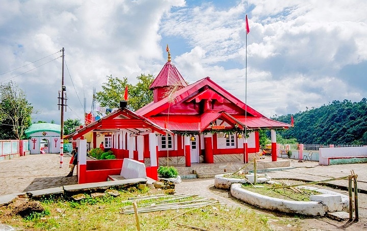
Hinduism is a minority religion in the Meghalaya state of India constituting 12% of the state's population. The Nartiang Durga Temple in Meghalaya is one of the 51 Shakti peethas on Earth and is considered by Hindus of Meghalaya as the permanent abode of Goddess Durga. Hinduism is a popular religion practice by Rabhas, Hajongs, Kochs, Rajbongshis, Mikirs, Bengalis, Nepalis, Biharis etc. Tradition Festivals Hinduism is practiced by different groups of Meghalaya. Hindus celebrate many festivals in Meghalya. Diwali, Behdienkhlam, Navaratri, etc. are celebrated by people. Navaratri and other Goddess Pujas are celebrated mainly by Bengali people. Diwali is celebrated by almost all Hindus. Behdienkhlam is celebrated by Pnar/Jaintia Hindus with Niamatre believers. In Jowai, Behdienkhlam is a harvest festival celebrate by Hindus and Niamatre believers. This festival is popular among non-Christian Pnar people(Jaintia). Many other Hindu festivals celebrate Hindus like Makar Sankran ... [...More Info...] [...Related Items...] OR: [Wikipedia] [Google] [Baidu] |
Nartiang Durga Temple
Nartiang Durga Temple is a 600-year-old temple located in the West Jaintia Hills district of Meghalaya in northeastern India. It is one of the 51 Shakti Peethas and is one of the holiest sites for devotees of the Shaktism sect of Hinduism. The Hindus in the Jaintia Hills of Meghalaya believes that this temple is the permanent abode of Goddess Durga. The temple draws a large number of pilgrims from all over the country on occasion of Durga Puja. The Shakti of Nartiang Devi shrine is worshipped as Jayanti and the Bhairava as Kamadishwar. Significance The Nartiang Devi Temple is believed to be a Shakti Peetha, one of the most revered shrines of Shaktism as Shakti Peethas are Holy abodes of Parashakti. The Shakti Peethas have originated from ''the mythology of Daksha yagna and Sati's self immolation'' Shiva carried the corpse of Sati Devi and 51 body parts of the corpse fell in the path He had wandered. Each temple has shrines for both Shakti as well as the corresponding male en ... [...More Info...] [...Related Items...] OR: [Wikipedia] [Google] [Baidu] |
Shakti
In Hinduism, especially Shaktism (a theological tradition of Hinduism), Shakti (Devanagari: शक्ति, IAST: Śakti; lit. "Energy, ability, strength, effort, power, capability") is the primordial cosmic energy, female in aspect, and represents the dynamic forces that are thought to move through the universe. She is thought of as creative, sustaining, as well as destructive, and is sometimes referred to as auspicious source energy. Shakti is sometimes personified as the creator goddess, and is known as "Adi Shakti" or "Adi Parashakti" ("inconceivableprimordial energy"). In Shaktism, Adi Parashakti is worshipped as the Supreme Being. On every plane of creation, energy manifests itself into all forms of matter; these are all thought to be infinite forms of Parashakti. She is described as ''anaadi'' (with no beginning, no ending) and ''nitya'' (forever). Origins One of the oldest representations of the goddess in India is in a triangular form. The Baghor stone, found in a ... [...More Info...] [...Related Items...] OR: [Wikipedia] [Google] [Baidu] |
Rabha Tribe
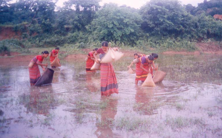
The Rabha are a Tibeto-Burman community to the Indian states of Assam, Meghalaya and West Bengal. They primarily inhabit the plains of Lower Assam and the Dooars, while some are found in the Garo Hills. Most of the Rabhas of Dooars refer to themselves as Rabha, but some of them often declare themselves as Kocha. The Rabha community have a rich, multi-faceted and distinct culture of their own. The agricultural practices, food habit and belief systems of the Rabhas reflect a conglomeration of features from both the Indo-Aryan and Tibeto-Burmese culture. The Rabha society is patrilineal . The village economy is based on agriculture and both men and women work in the fields. The women wear colorful clothes that they weave themselves and wear a lot of beads and silver ornaments. The Rabhas are non-vegetarians and rice is their staple food. The traditional economy of the Rabhas in general, is based on agriculture, forest based activities and weaving. In the past, the Rabhas used to pra ... [...More Info...] [...Related Items...] OR: [Wikipedia] [Google] [Baidu] |
Rajbongshi People
The Rajbanshi, also Rajbongshi and Koch-Rajbongshi, are peoples from Lower Assam, North Bengal, eastern Bihar, Terai region of eastern Nepal, and Bhutan who have in the past sought an association with the Koch dynasty. Today, they speak various Indo-Aryan languages, though in the past they might have spoken Tibeto-Burman languages. In 2020, Kamatapur Autonomous Council has been created for socio-economic development and political rights of Koch-Rajbongshi community. They are related to the ethnic Koch people found in Meghalaya but are distinguished from them as well as from the Hindu caste called Koch (caste), Koch in Upper Assam that receives converts from different tribes. Rajbanshi (''of royal lineage'') alludes to the community's claimed connection with the Koch dynasty. Etymology The Rajbanshi (literal meaning: ''of the royal lineage'') community gave itself this name after 1891 following a movement to distance itself from an ethnic identity and acquire the higher ... [...More Info...] [...Related Items...] OR: [Wikipedia] [Google] [Baidu] |
Koch People
The Koch are a small trans-border ethnic group of Assam and Meghalaya in India and northern Bangladesh. The group consists of nine matrilineal and strictly exogamous clans, with some of them preserving a hitherto sparsely documented Boro-Garo language called Koch, whereas others have switched to local varieties of Indo-Aryan languages. It is a Scheduled Tribe in Meghalaya, India. Koches want to preserve language and culture and heritage. The Koch people in this group are those who have preserved their languages, their animistic religions and follow non-Hindu customs and traditions. They are related but distinguished from the empire building Koch (the Rajbongshi people) and the Hindu caste called Koch in Upper Assam which receives converts from different tribes. Etymology of ''Koch'' According to Tabaqat-i-Nasiri, western Kamrud (Kamrup) was inhabited by the ''Koch'', ''Mech'' & '' Tharu''. In Yogini Tantra, Koches were called as Kuvachas. According to the Fatiyah-i-Ibria ... [...More Info...] [...Related Items...] OR: [Wikipedia] [Google] [Baidu] |
Hajong People
The Hajong people are an ethnic group from Northeast India and northern parts of Bangladesh. The majority of the Hajongs are settled in India and are predominantly rice-farmers. They are said to have brought wet-field cultivation to Garo Hills, where the Garo people used slash and burn method of agriculture.Ahmad, S., A. Kim, S. Kim, and M. Sangma. (2005). ''The Hajong of Bangladesh: A sociolinguistic survey.'' http://www.sil.org/resources/publications/entry/42943. Hajong have the status of a Scheduled Tribe in India and they are the fourth largest tribal ethnicity in the Indian state of Meghalaya. Origin The Hajongs belong to the Bodo-Kachari group of tribes, whose ancestors migrated from Tibet to the Brahmaputra Valley in the ancient past, from where they spread in multiple directions. The Hajongs have no recorded history and whatever historical references available are in the form of legends, folktales and traditional beliefs. The Hajongs believe that their ancestral land ... [...More Info...] [...Related Items...] OR: [Wikipedia] [Google] [Baidu] |
Shillong
Shillong () is a hill station and the capital of Meghalaya, a Indian state, state in northeastern India, which means "The Abode of Clouds". It is the headquarters of the East Khasi Hills district. Shillong is the list of most populous cities in India, 330th most populous city in India with a population of 143,229 according to the 2011 census. It is said that the rolling hills around the town reminded the British of Scotland. Hence, they would also refer to it as the "Scotland of the East". Shillong has steadily grown in size since it was made the civil station of the Khasi Hills, Khasi and Jaintia Hills in 1864 by the British. In 1874, on the formation of Assam as the Chief Commissioner's Province, it was chosen as the headquarters of the new administration because of its convenient location between the Brahmaputra and Surma River, Surma valleys and more so because the climate of Shillong was much cooler than tropical India. Shillong remained the capital of undivided Assam until ... [...More Info...] [...Related Items...] OR: [Wikipedia] [Google] [Baidu] |
East Khasi Hills District
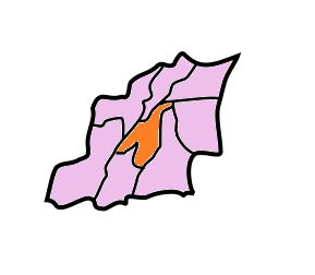
East Khasi Hills is an administrative district in the state of Meghalaya in India. The district headquarters are located at Shillong. The district occupies an area of 2752 km² and has a population of 825,922 (as of 2011). , it is the most populous district of Meghalaya's 12 districts. History The former Khasi Hills district was divided into East and West Khasi Hills districts on 28 October 1976. On 4 June 1992, East Khasi Hills District was further divided into two administrative districts of East Khasi Hills District and Ri-Bhoi District. Geography Shillong is the district headquarters of East Khasi Hills District. East Khasi Hills District forms a central part of Meghalaya and covers a total geographical area of 2,748 km2. It lies approximately between 25°07" & 25°41" N Lat. And 91°21" & 92°09" E Long. The north of the district is bounded by the plain of Ri-Bhoi District gradually rising to the rolling grasslands of the Shillong Plateau interspersed wit ... [...More Info...] [...Related Items...] OR: [Wikipedia] [Google] [Baidu] |
West Garo Hills District
West Garo Hills is an administrative district in Garo Hills of the state of Meghalaya in India. Tura town is the administrative headquarters of the district. The district occupies an area of 3714 km². In 2011 its population was 643,291. As of 2011 it is the second most populous district of Meghalaya (out of 7), after East Khasi Hills. West Garo Hills district is located at the westernmost part of Meghalaya. The district is bounded by East Garo Hills district on the east, by South Garo Hills district on the south-east, Goalpara district of Assam state on the north and north-west and Bangladesh on the south. History In 22 October 1976 the Garo Hills district was bifurcated into two districts: West Garo Hills district and East Garo Hills district. The West Garo Hills district was further divided into two districts: the present day West Garo Hills district and South Garo Hills district in June 1992. Economy In 2006 the Ministry of Panchayati Raj named West Garo Hills one of ... [...More Info...] [...Related Items...] OR: [Wikipedia] [Google] [Baidu] |
Census Of India
The decennial Census of India has been conducted 16 times, as of 2021. While it has been undertaken every 10 years, beginning in 1872 under British Viceroy Lord Mayo, the first complete census was taken in 1881. Post 1949, it has been conducted by the Registrar General and Census Commissioner of India under the Ministry of Home Affairs, Government of India. All the censuses since 1951 were conducted under the 1948 Census of India Act. The last census was held in 2011, whilst the next was to be held in 2021. But it has been postponed due to the COVID-19 pandemic. Historically, there has been a long time between collection of data and dissemination of data. Census of India during British Rule List of censuses conducted in India before independence: * 1872 Census of india *1881 Census of India *1891 Census of India * 1901 Census of India *1911 Census of India * 1921 Census of India * 1931 Census of India *1941 Census of India Census of Republic of India List of censuses conduct ... [...More Info...] [...Related Items...] OR: [Wikipedia] [Google] [Baidu] |


