|
Harrison, AR
Harrison is a city and the county seat of Boone County, Arkansas, United States. It is named after General Marcus LaRue Harrison, a surveyor who laid out the city along Crooked Creek at Stifler Springs. According to 2019 Census Bureau estimates, the population of the city was 13,069, up from 12,943 at the 2010 census and it is the 30th largest city in Arkansas based on official 2019 estimates from the U.S. Census Bureau. Harrison is the principal city of the Harrison Micropolitan Statistical Area, which includes all of Boone and Newton counties. The community has a history of racism: there were two race riots in the early 20th century and an influx of white supremacist organizations during the late 20th and early 21st centuries. Because of this, a number of sources have called it "the most racist town in the United States". History Native Americans were the earliest inhabitants of the area, probably beginning with cliff dwellers who lived in caves in the bluffs along the ... [...More Info...] [...Related Items...] OR: [Wikipedia] [Google] [Baidu] |
Harrison Courthouse Square Historic District
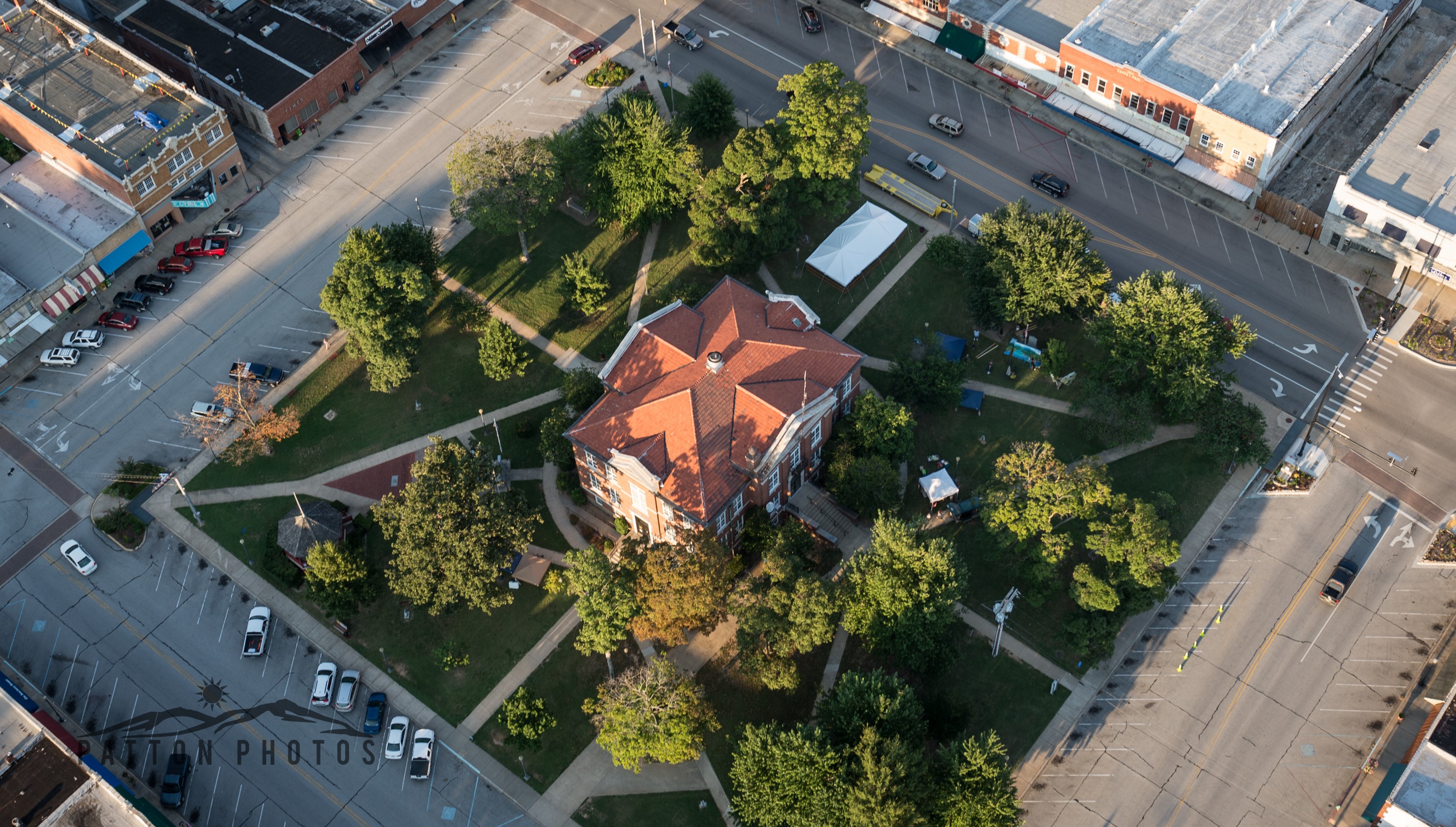
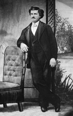
The Harrison Courthouse Square Historic District is an area of Harrison, Arkansas. It is known by residents simply as "the Square". The Harrison Courthouse Square Historic District includes the 1911 Boone County Courthouse, two pharmacies, several clothing stores and restaurants, and a Marine Corps Legacy Museum. The District also has a bank and the Lyric Theater. The District is the site of several annual festivals, including Crawdad Days and the Fall Festival. Several war memorials stand on the Courthouse lawn. The Square is known as the site of the shooting of famous outlaw Henry Starr. Most of the square's buildings were built between 1895 and 1948, earlier buildings having been predominantly wooden in construction. The district that was listed on the National Register of Historic Places in 1999 has 54 historically significant buildings, including most of those facing the 1911 courthouse, and a few on the immediately adjacent city blocks. See also *National Register of ... [...More Info...] [...Related Items...] OR: [Wikipedia] [Google] [Baidu] |
Downtown Harrison, AR Courthouse Square
''Downtown'' is a term primarily used in North America by English speakers to refer to a city's sometimes commercial, cultural and often the historical, political and geographic heart. It is often synonymous with its central business district (CBD). Downtowns typically contain a small percentage of a city’s employment. In some metropolitan areas it is marked by a cluster of tall buildings, cultural institutions and the convergence of rail transit and bus lines. In British English, the term "city centre" is most often used instead. History Origins The Oxford English Dictionary's first citation for "down town" or "downtown" dates to 1770, in reference to the center of Boston. Some have posited that the term "downtown" was coined in New York City, where it was in use by the 1830s to refer to the original town at the southern tip of the island of Manhattan.Fogelson, p. 10. As the town of New York grew into a city, the only direction it could grow on the island was toward the nor ... [...More Info...] [...Related Items...] OR: [Wikipedia] [Google] [Baidu] |
Mountain Meadows Massacre
The Mountain Meadows Massacre (September 7–11, 1857) was a series of attacks during the Utah War that resulted in the mass murder of at least 120 members of the Baker–Fancher party, Baker–Fancher emigrant wagon train. The massacre occurred in the southern Utah Territory at Mountain Meadows, Utah, Mountain Meadows, and was perpetrated by the Mormon settlers belonging to the Utah Territorial Militia (officially called the Nauvoo Legion) who recruited and were aided by some Southern Paiute people, Southern Paiute Native Americans in the United States, Native Americans. The wagon train, made up mostly of families from Arkansas, was bound for California, traveling on the Old Spanish Trail (trade route), Old Spanish Trail that passed through the Territory. After arriving in Salt Lake City, the Baker–Fancher party made their way south along the Mormon Road, eventually stopping to rest at Mountain Meadows. As the party was traveling west there were rumors about the party's beh ... [...More Info...] [...Related Items...] OR: [Wikipedia] [Google] [Baidu] |
White River (Arkansas)
White River may refer to: Bodies of water Africa * Bakoy River, in West Africa, called the White River over a portion of its length Canada * White River (British Columbia) * White River (Vancouver Island), a river in the Discovery Passage–Johnstone Strait watersheds of British Columbia ** White River Provincial Park * White River (Nass River), a river in the Marcus Passage watershed of British Columbia * White River (Quebec) * White River (Yukon) The White River (french: Rivière Blanche) ( Hän: ''Tadzan ndek'') is a tributary about long, of the Yukon River in the U.S. state of Alaska and the Canadian territory of Yukon. The Alaska Highway [Baidu] |
Hernando De Soto
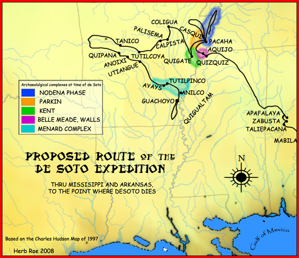
Hernando de Soto (; ; 1500 – 21 May, 1542) was a Spanish explorer and '' conquistador'' who was involved in expeditions in Nicaragua and the Yucatan Peninsula. He played an important role in Francisco Pizarro's conquest of the Inca Empire in Peru, but is best known for leading the first European expedition deep into the territory of the modern-day United States (through Florida, Georgia, Alabama, Mississippi, and most likely Arkansas). He is the first European documented as having crossed the Mississippi River. De Soto's North American expedition was a vast undertaking. It ranged throughout what is now the southeastern United States, both searching for gold, which had been reported by various Native American tribes and earlier coastal explorers, and for a passage to China or the Pacific coast. De Soto died in 1542 on the banks of the Mississippi River; different sources disagree on the exact location, whether it was what is now Lake Village, Arkansas, or Ferriday, Louisia ... [...More Info...] [...Related Items...] OR: [Wikipedia] [Google] [Baidu] |
Indian Territory
The Indian Territory and the Indian Territories are terms that generally described an evolving land area set aside by the Federal government of the United States, United States Government for the relocation of Native Americans in the United States, Native Americans who held aboriginal title to their land as a sovereign independent state. In general, the tribes ceded land they occupied in exchange for Land grant#United States, land grants in 1803. The concept of an Indian Territory was an outcome of the US federal government's 18th- and 19th-century policy of Indian removal. After the Indian Territory in the American Civil War, American Civil War (1861–1865), the policy of the US government was one of Cultural assimilation of Native Americans#Americanization and assimilation (1857–1920), assimilation. The term ''Indian Reserve (1763), Indian Reserve'' describes lands the Kingdom of Great Britain, British set aside for Indigenous tribes between the Appalachian Mountains and t ... [...More Info...] [...Related Items...] OR: [Wikipedia] [Google] [Baidu] |
Cherokee
The Cherokee (; chr, ᎠᏂᏴᏫᏯᎢ, translit=Aniyvwiyaʔi or Anigiduwagi, or chr, ᏣᎳᎩ, links=no, translit=Tsalagi) are one of the indigenous peoples of the Southeastern Woodlands of the United States. Prior to the 18th century, they were concentrated in their homelands, in towns along river valleys of what is now southwestern North Carolina, southeastern Tennessee, edges of western South Carolina, northern Georgia, and northeastern Alabama. The Cherokee language is part of the Iroquoian language group. In the 19th century, James Mooney, an early American ethnographer, recorded one oral tradition that told of the tribe having migrated south in ancient times from the Great Lakes region, where other Iroquoian peoples have been based. However, anthropologist Thomas R. Whyte, writing in 2007, dated the split among the peoples as occurring earlier. He believes that the origin of the proto-Iroquoian language was likely the Appalachian region, and the split betw ... [...More Info...] [...Related Items...] OR: [Wikipedia] [Google] [Baidu] |
Caddo
The Caddo people comprise the Caddo Nation of Oklahoma, a federally recognized tribe headquartered in Binger, Oklahoma. They speak the Caddo language. The Caddo Confederacy was a network of Indigenous peoples of the Southeastern Woodlands, who historically inhabited much of what is now East Texas, west Louisiana, southwestern Arkansas, and southeastern Oklahoma. Prior to European contact, they were the Caddoan Mississippian culture, who constructed huge earthwork mounds at several sites in this territory, flourishing about 800 to 1400 CE. In the early 19th century, Caddo people were forced to a reservation in Texas. In 1859, they were removed to Indian Territory. Government and civic institutions The Caddo Nation of Oklahoma was previously known as the Caddo Tribe of Oklahoma. The tribal constitution provides for election of an eight-person council, with a chairperson. Some 6,000 people are enrolled in the nation, with 3,044 living within the state of Oklahoma. [...More Info...] [...Related Items...] OR: [Wikipedia] [Google] [Baidu] |
Quapaw
The Quapaw ( ; or Arkansas and Ugahxpa) people are a tribe of Native Americans that coalesced in what is known as the Midwest and Ohio Valley of the present-day United States. The Dhegiha Siouan-speaking tribe historically migrated from the Ohio Valley area to the west side of the Mississippi River in what is now the state of Arkansas; their name for themselves (or autonym) refers to this migration and to traveling downriver. The Quapaw are federally recognized as the Quapaw Nation. The US federal government forcibly removed them to Indian Territory in 1834, and their tribal base has been in present-day Ottawa County in northeastern Oklahoma. The number of members enrolled in the tribe was 3,240 in 2011. Name Algonquian-speaking people called the Quapaw ''akansa''. French explorers and colonists learned this term from Algonquians and adapted it in French as ''Arcansas''. The French named the Arkansas River and the territory of Arkansas for them. Government The Quapaw Natio ... [...More Info...] [...Related Items...] OR: [Wikipedia] [Google] [Baidu] |
Shawnee
The Shawnee are an Algonquian-speaking indigenous people of the Northeastern Woodlands. In the 17th century they lived in Pennsylvania, and in the 18th century they were in Pennsylvania, Ohio, Indiana and Illinois, with some bands in Kentucky and Alabama. By the 19th century, they were forcibly removed to Missouri, Kansas, Texas, and ultimately Indian Territory, which became Oklahoma under the 1830 Indian Removal Act. Today, Shawnee people are enrolled in three federally recognized tribes, all headquartered in Oklahoma: the Absentee-Shawnee Tribe of Indians, Eastern Shawnee Tribe of Oklahoma, and Shawnee Tribe. Etymology Shawnee has also been written as Shaawanwaki, Ša·wano·ki, Shaawanowi lenaweeki, and Shawano. Algonquian languages have words similar to the archaic ''shawano'' (now: ''shaawanwa'') meaning "south". However, the stem ''šawa-'' does not mean "south" in Shawnee, but "moderate, warm (of weather)": See Charles F. Voegelin, "šawa (plus -ni, -te) MODERATE, WARM ... [...More Info...] [...Related Items...] OR: [Wikipedia] [Google] [Baidu] |
Ozarks
The Ozarks, also known as the Ozark Mountains, Ozark Highlands or Ozark Plateau, is a physiographic region in the U.S. states of Missouri, Arkansas, Oklahoma and the extreme southeastern corner of Kansas. The Ozarks cover a significant portion of northern Arkansas and most of the southern half of Missouri, extending from Interstate 40 in central Arkansas to Interstate 70 in central Missouri. There are two mountain ranges in the Ozarks: the Boston Mountains of Arkansas and the St. Francois Mountains of Missouri. Buffalo Lookout, the highest point in the Ozarks, is located in the Boston Mountains. Geologically, the area is a broad dome with the exposed core in the ancient St. Francois Mountains. The Ozarks cover nearly , making it the most extensive highland region between the Appalachians and Rockies. Together with the Ouachita Mountains, the area is known as the U.S. Interior Highlands. The Salem Plateau, named after Salem, Missouri, makes up the largest geologic area o ... [...More Info...] [...Related Items...] OR: [Wikipedia] [Google] [Baidu] |
Sioux
The Sioux or Oceti Sakowin (; Dakota language, Dakota: Help:IPA, /otʃʰeːtʰi ʃakoːwĩ/) are groups of Native Americans in the United States, Native American tribes and First Nations in Canada, First Nations peoples in North America. The modern Sioux consist of two major divisions based on Siouan languages, language divisions: the Dakota people, Dakota and Lakota people, Lakota; collectively they are known as the Očhéthi Šakówiŋ ("Seven Council Fires"). The term "Sioux" is an exonym created from a French language, French transcription of the Ojibwe language, Ojibwe term "Nadouessioux", and can refer to any ethnic group within the Great Sioux Nation or to any of the nation's many language dialects. Before the 17th century, the Dakota people, Santee Dakota (; "Knife" also known as the Eastern Dakota) lived around Lake Superior with territories in present-day northern Minnesota and Wisconsin. They gathered wild rice, hunted woodland animals and used canoes to fish. Wars ... [...More Info...] [...Related Items...] OR: [Wikipedia] [Google] [Baidu] |


