|
Gomal River
Gomal River ( ur, , ps, ګومل سیند، ګومل دریاب) is a river in Afghanistan and Pakistan. It rises in the northern part of Afghanistan's Paktika Province. It joins the Indus River 20 miles south of Dera Ismail Khan, Khyber Pakhtunkhwa. The river lends its name to the Gomal University in Dera Ismail Khan and the like-named Gomal District in Paktika Province. Etymology The name ''Gomal'' is thought to have derived from the river ''Gomati'', which is mentioned in the ''Rigveda''. Course Gomal River's headwaters are located in the northern part of Paktika Province, southeast of the city of Ghazni. The springs which form the headwaters of the Gomal's main branch emerge above the fort at Babakarkol in Katawaz, a district in Paktika inhabited by Ghilji Pashtuns from the Kharoti and Sulaimankhel clans. The Gomal's other branch, the "Second Gomal", joins the main channel about 14 miles below its source. The Gomal flows southeast through the eastern Ghilji country bef ... [...More Info...] [...Related Items...] OR: [Wikipedia] [Google] [Baidu] |
Afghanistan
Afghanistan, officially the Islamic Emirate of Afghanistan,; prs, امارت اسلامی افغانستان is a landlocked country located at the crossroads of Central Asia and South Asia. Referred to as the Heart of Asia, it is bordered by Pakistan to the east and south, Iran to the west, Turkmenistan to the northwest, Uzbekistan to the north, Tajikistan to the northeast, and China to the northeast and east. Occupying of land, the country is predominantly mountainous with plains in the north and the southwest, which are separated by the Hindu Kush mountain range. , its population is 40.2 million (officially estimated to be 32.9 million), composed mostly of ethnic Pashtuns, Tajiks, Hazaras, and Uzbeks. Kabul is the country's largest city and serves as its capital. Human habitation in Afghanistan dates back to the Middle Paleolithic era, and the country's Geostrategy, strategic location along the historic Silk Road has led it to being described, pict ... [...More Info...] [...Related Items...] OR: [Wikipedia] [Google] [Baidu] |
South Waziristan
South Waziristan District ( ps, سويلي وزیرستان ولسوالۍ, ur, ) was a district in Dera Ismail Khan Division of Khyber Pakhtunkhwa before splitting in to Lower South Waziristan District and Upper South Waziristan District and the southern part of Waziristan, a mountainous region of northwest Pakistan, that covers some 11,585 km2 (4,473 mi²). Waziristan comprises the area west and southwest of Peshawar between the Tochi River to the north and the Gomal River to the south. The region was an independent tribal territory from 1893, remaining outside of British-ruled empire and Afghanistan. Tribal raiding into British-ruled territory was a constant problem for the British, requiring frequent punitive expeditions between 1860 and 1945. Troops of the British Raj coined a name for this region "Hell's Door Knocker" in recognition of the fearsome reputation of the local fighters and inhospitable terrain. The capital city of South Waziristan is Wanna. South ... [...More Info...] [...Related Items...] OR: [Wikipedia] [Google] [Baidu] |
Rivers Of Balochistan (Pakistan)
A river is a natural flowing watercourse, usually freshwater, flowing towards an ocean, sea, lake or another river. In some cases, a river flows into the ground and becomes dry at the end of its course without reaching another body of water. Small rivers can be referred to using names such as creek, brook, rivulet, and rill. There are no official definitions for the generic term river as applied to geographic features, although in some countries or communities a stream is defined by its size. Many names for small rivers are specific to geographic location; examples are "run" in some parts of the United States, "burn" in Scotland and northeast England, and "beck" in northern England. Sometimes a river is defined as being larger than a creek, but not always: the language is vague. Rivers are part of the water cycle. Water generally collects in a river from precipitation through a drainage basin from surface runoff and other sources such as groundwater recharge, springs, ... [...More Info...] [...Related Items...] OR: [Wikipedia] [Google] [Baidu] |
Gomal Pass
Gomal Pass ( ps, ګومل) is a mountain pass on the Durand Line border between Afghanistan and the southeastern portion of South Waziristan in Pakistan's Federally Administered Tribal Areas. It takes its name from the Gomal River and is midway between the legendary Khyber Pass and the Bolan Pass. It connects Ghazni in Afghanistan with Tank and Dera Ismail Khan in Pakistan. Gomal Pass, for a long time, has been a trading route for nomadic Powindahs. Two Pakistani rivers of Shna Pasta and Shore Mānda as well as Mandz Rāghah Kowri stream in Afghanistan flow close to Gomal Pass. See also * Gomal River * Gomal Zam Dam *Gomal University Gomal University ( Urdu: جامعہ گومل), is a public research university located in Dera Ismail Khan in the Khyber-Pakhtunkhwa province of Pakistan. Founded and established in 1974, the university is one of the oldest institutions in the ... * Gomal District References Mountain passes of Afghanistan Afghanistan–Pakistan ... [...More Info...] [...Related Items...] OR: [Wikipedia] [Google] [Baidu] |
Islamabad
Islamabad (; ur, , ) is the capital city of Pakistan. It is the country's ninth-most populous city, with a population of over 1.2 million people, and is federally administered by the Pakistani government as part of the Islamabad Capital Territory. Built as a planned city in the 1960s, it replaced Rawalpindi as Pakistan's national capital. The city is notable for its high standards of living, safety, cleanliness, and abundant greenery. Greek architect Constantinos Apostolou Doxiadis developed Islamabad's master plan, in which he divided it into eight zones; administrative, diplomatic enclave, residential areas, educational and industrial sectors, commercial areas, as well as rural and green areas administered by the Islamabad Metropolitan Corporation with support from the Capital Development Authority. Islamabad is known for the presence of several parks and forests, including the Margalla Hills National Park and the Shakarparian. It is home to several landmarks, i ... [...More Info...] [...Related Items...] OR: [Wikipedia] [Google] [Baidu] |
Pervez Musharraf
General Pervez Musharraf ( ur, , Parvez Muśharraf; born 11 August 1943) is a former Pakistani politician and four-star general of the Pakistan Army who became the tenth president of Pakistan after the successful military takeover of the federal government in 1999. He also served as the 10th Chairman Joint Chiefs of Staff Committee from 1998 to 2001 and the 7th Chief of Army Staff from 1998 to 2007. Born in Delhi during the British Raj, Musharraf was raised in Karachi and Istanbul. He studied mathematics at Forman Christian College in Lahore and was also educated at the Royal College of Defence Studies in the United Kingdom. Musharraf entered the Pakistan Military Academy in 1961 and was commissioned to the Pakistan Army in 1964. Musharraf saw action during the Indo-Pakistani War of 1965 as a second lieutenant. By the 1980s, he was commanding an artillery brigade. In the 1990s, Musharraf was promoted to major general and assigned an infantry division, and later c ... [...More Info...] [...Related Items...] OR: [Wikipedia] [Google] [Baidu] |
Gomal Zam Dam
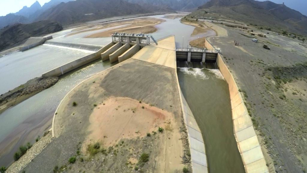
Gomal Zam Dam ( ur, ) is a multi-purpose gravity dam in South Waziristan Tribal District of Khyber Pakhtunkhwa, Pakistan. The dam impounds the Gomal River, a tributary of the Indus River, at Khjori Kach, where the Gomal River passes through a narrow ravine. The purpose of the dam is irrigation, flood control, and hydroelectric power generation. Construction of the dam began in August 2001 and was completed in April 2011. The powerhouse was completed in March 2013 and electricity production started in August 2013. The dam was officially inaugurated on 12 September 2013 by Minister for Water and Power Khawaja Muhammad Asif, along with US Ambassador Richard G. Olson and Khyber Pakhtunkhwa Governor Shaukatullah Khan. Features Gomal Dam is a roller-compacted concrete (RCC) gravity dam with a height of 437 feet (133 m). It has a gross storage capacity of and the 60.5 km long main canal can irrigate about of barren land in Tank district and Tehsil Kulachi of Dera Ismail Kha ... [...More Info...] [...Related Items...] OR: [Wikipedia] [Google] [Baidu] |
Construction Of Gomal Zam Dam
Construction is a general term meaning the art and science to form objects, systems, or organizations,"Construction" def. 1.a. 1.b. and 1.c. ''Oxford English Dictionary'' Second Edition on CD-ROM (v. 4.0) Oxford University Press 2009 and comes from Latin ''constructio'' (from ''com-'' "together" and ''struere'' "to pile up") and Old French ''construction''. To construct is the verb: the act of building, and the noun is construction: how something is built, the nature of its structure. In its most widely used context, construction covers the processes involved in delivering buildings, infrastructure, industrial facilities and associated activities through to the end of their life. It typically starts with planning, financing, and design, and continues until the asset is built and ready for use; construction also covers repairs and maintenance work, any works to expand, extend and improve the asset, and its eventual demolition, dismantling or decommissioning. The constructio ... [...More Info...] [...Related Items...] OR: [Wikipedia] [Google] [Baidu] |
Dera Ismail Khan Tehsil
Dera Ismail Khan Tehsil is a tehsil located in Dera Ismail Khan District, Khyber Pakhtunkhwa, Pakistan.Tehsils & Unions in the District of D.I. Khan - Government of Pakistan Administration The tehsil is administratively subdivided into 21 Union Councils, four of which form the headquarters - .History [...More Info...] [...Related Items...] OR: [Wikipedia] [Google] [Baidu] |
Kulachi Tehsil
Kulachi Tehsil is a tehsil located in Dera Ismail Khan District, Khyber Pakhtunkhwa, Pakistan.Tehsils & Unions in the District of D.I. Khan - Government of Pakistan Administration The tehsil is administratively subdivided into 15 Union Councils, one of which forms the headquarters - Kulachi.History During Kulachi was a tehsil of the old |
Rod Koh
Rod Koh or Rod Kohi ( fa, راد کوہ) is a form of irrigation system in Pakistan. ''Rod'' means ''channel'' and ''Koh'' means ''mountain'' in Persian. The Rod Kohi system based on Kulyat Riwajat (Fromulae and Traditions) which governed the irrigation system ever since the Pashtun tribes moved into Damaan. The British officers moved all these to writing during their Land Settlements in the later part of the nineteenth century. The Bolton Irrigation Notes of 1908 are still considered the Bible of Rod Kohi irrigation. Rod Koh is the main torrent bed which usually remains dry, when there is no flood, whereas Zam means the flow of perennial water coming out of springs. The flood and perennial water of the Zam is used for irrigation and drinking purpose. Zam water is classified into two categories: ''Buga Pani'' (flood water) and ''Kala Pani'' (perennial water). Rod Koh (torrent-spate-irrigation) systems go back at least as early as 330 BC and provided economic basis for some of ... [...More Info...] [...Related Items...] OR: [Wikipedia] [Google] [Baidu] |


