|
Gallery Road
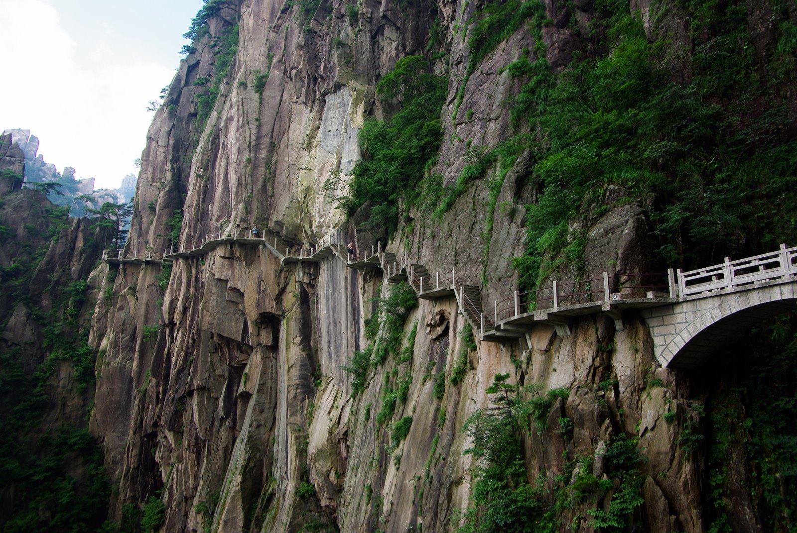
The archaeological gallery roads () were roads through remote mountain areas of China. They consisted of wooden planks erected on holes cut into the sides of cliffs. They were most notably used in the Qin Mountains linking the Wei River and the Han River valleys. The first gallery roads were built during the Warring States period (476-221 BC) and used by Qin to invade Shu and Ba. They were fully consolidated into a thriving network during the Han Dynasty. Before the 20th century, very primitive versions were used in the western gorges of the Pamir Mountains. Introduction Gallery road, also known as cliff road, plank road, is a creative building in Chinese history. The main use of the gallery road is to establish a traffic route over a cliff in a steep mountainous area. The Shu Road is the most typical representative. It passes through some of the most rugged and desolate terrains in China, such as the Qinling Mountains and the Daba Mountain ranges, linking the Wei river v ... [...More Info...] [...Related Items...] OR: [Wikipedia] [Google] [Baidu] |
Ancient Roads And Tracks
Ancient history is a time period from the History of writing, beginning of writing and recorded human history to as far as late antiquity. The span of recorded history is roughly 5,000 years, beginning with the Sumerian language, Sumerian cuneiform script. Ancient history covers all continents inhabited by humans in the period 3000 BCAD 500. The three-age system periodizes ancient history into the Stone Age, the Bronze Age, and the Iron Age, with recorded history generally considered to begin with the Bronze Age. The start and end of the three ages varies between world regions. In many regions the Bronze Age is generally considered to begin a few centuries prior to 3000 BC, while the end of the Iron Age varies from the early first millennium BC in some regions to the late first millennium AD in others. During the time period of ancient history, the world population was already Exponential growth, exponentially increasing due to the Neolithic Revolution, which was in full pro ... [...More Info...] [...Related Items...] OR: [Wikipedia] [Google] [Baidu] |
Shudao
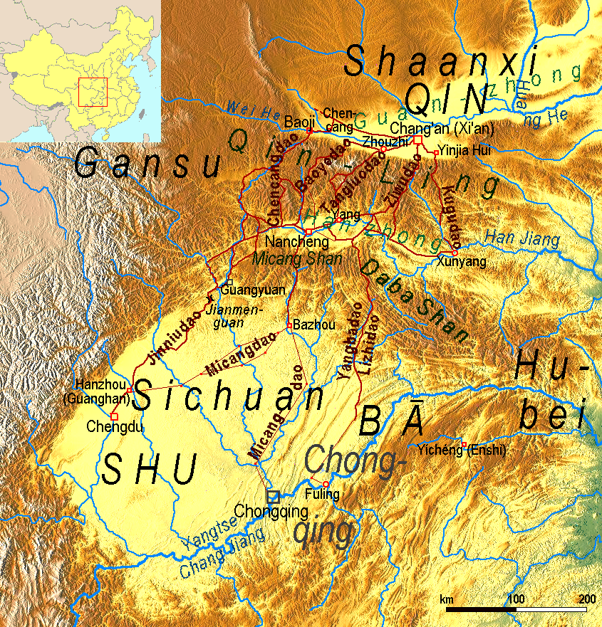
The Shudao (), or the Road(s) to Shu, is a system of mountain roads linking the Chinese province of Shaanxi with Sichuan (Shu), built and maintained since the 4th century BC. Technical highlights were the gallery roads, consisting of wooden planks erected on wooden or stone beams slotted into holes cut into the sides of cliffs. Geography The roads join three adjacent basins separated and surrounded by high mountains. The northern basin is called Guanzhong ("between the passes"). It is drained by the Yellow River. In ancient times it was the heart of the state of Qin, nowadays it is the central region of Shaanxi. To the south it is bounded by the Qinling Mountains. South of that range is the Hanzhong basin, drained by the Han River, a tributary of the Yangtze. The Hanzhong basin is divided from the Sichuan basin by mountain ranges called the Micang Shan (米倉山/米仓山, ''Mǐcāng Shān'', "Rice Granary Mountains") in the west and Daba Mountains in the east. The Sichuan ... [...More Info...] [...Related Items...] OR: [Wikipedia] [Google] [Baidu] |
List Of Archaeological Sites By Country
This is a list of notable archaeological sites sorted by country and territories. For one sorted by continent and time period, see the list of archaeological sites by continent and age. Afghanistan * Aï Khānum *Bagram *Buddhas of Bamiyan * Hadda *Haji Piyada mosque in Balkh *Mes Aynak *Minarets in Ghazni * Mousallah Complex * Surkh Kotal *Takht-i-rustam *Tillya Tepe Albania *Amantia * Antigonia *Antipatrea (modern Berat) * Apollonia *Buthrotum *Byllis *Dimale *Epidamnos or Dyrrachium (modern Durrës) *Lissos or Lissus (modern Lezhë) *Oricum *Phoenice (modern Finiq) *Scodra (modern Shkodër) Algeria * Aïn Turk, Bouïra * Altava *Beni Hammad Fort *Bir el Ater *Cirta *Diana Veteranorum *Djémila *Fossatum Africae *Gemellae *Ghoufi *Oricum *Hammam Essalihine * Hippo Regius *Jedars *Lambaesis *Mila, Algeria *Miliana *Partenia *Qalʿat ibn Salama *Roknia *Royal Mausoleum of Mauretania *Tassili n'Ajjer *Tébessa *Timgad *Tipaza *Uzinaza Argentina *Cueva de las Manos *Pied ... [...More Info...] [...Related Items...] OR: [Wikipedia] [Google] [Baidu] |
Skyway
A skyway, skybridge, skywalk, or sky walkway is an elevated type of pedway connecting two or more buildings in an urban area, or connecting elevated points within mountainous recreational zones. Urban skyways very often take the form of enclosed or covered footbridges that protect pedestrians from the weather. Open-top modern skyways in mountains now often have glass bottoms. Sometimes enclosed urban skywalks are made almost totally from glass, including ceilings, walls and floors. Also, some urban skyways function strictly as linear parks designed for walking. In North America skyways are usually owned by businesses, and are therefore not public spaces (compare with sidewalk). However, in Asia, such as Bangkok's and Hong Kong's skywalks, they are built and owned separately by the city government, connecting between privately run rail stations or other transport with their own footbridges, and run many kilometers. Skyways usually connect on the first few floors above the ground ... [...More Info...] [...Related Items...] OR: [Wikipedia] [Google] [Baidu] |
Covered Bridge
A covered bridge is a timber-truss bridge with a roof, decking, and siding, which in most covered bridges create an almost complete enclosure. The purpose of the covering is to protect the wooden structural members from the weather. Uncovered wooden bridges typically have a lifespan of only 20 years because of the effects of rain and sun, but a covered bridge could last over 100 years. In the United States, only about 1 in 10 survived the 20th century. The relatively small number of surviving bridges is due to deliberate replacement, neglect, and the high cost of restoration. European and North American truss bridges Typically, covered bridges are structures with longitudinal timber-trusses which form the bridge's backbone. Some were built as railway bridges, using very heavy timbers and doubled up lattice work. In Canada and the U.S., numerous timber covered bridges were built in the late 1700s to the late 1800s, reminiscent of earlier designs in Germany and Switzerland. Th ... [...More Info...] [...Related Items...] OR: [Wikipedia] [Google] [Baidu] |
Stone Cattle Road
The Stone Cattle Road () was an ancient Chinese road over the Qinling Mountains used by the state of Qin to conquer Sichuan in 316 BC. Story The story goes that King Huiwen of Qin on the Wei River wished to conquer the kingdom of Shu to the south over the impassable Qinling Mountains in the Sichuan Basin. Knowing of the King of Shu's fondness for treasure, he had his sculptors make five life-sized stone cows with gold tails and hindquarters with gold and placed them where the Shu ambassadors could see them. When the king of Shu heard of this, he thought it would be good to fertilize his treasury with golden cowpats, so he asked the king of Qin to send the cattle. The king of Qin replied that he was glad to do so, but the cattle were delicate and that to deliver them it would first be necessary to build a gallery road over the mountains. When this Stone Cattle Road was completed in 316 BC he used it to invade and conquer Shu. Sage gives a slightly different version of the story. A ... [...More Info...] [...Related Items...] OR: [Wikipedia] [Google] [Baidu] |
Shu Road
The Shudao (), or the Road(s) to Shu, is a system of mountain roads linking the Chinese province of Shaanxi with Sichuan (Shu), built and maintained since the 4th century BC. Technical highlights were the gallery roads, consisting of wooden planks erected on wooden or stone beams slotted into holes cut into the sides of cliffs. Geography The roads join three adjacent basins separated and surrounded by high mountains. The northern basin is called Guanzhong ("between the passes"). It is drained by the Yellow River. In ancient times it was the heart of the state of Qin, nowadays it is the central region of Shaanxi. To the south it is bounded by the Qinling Mountains. South of that range is the Hanzhong basin, drained by the Han River, a tributary of the Yangtze. The Hanzhong basin is divided from the Sichuan basin by mountain ranges called the Micang Shan (米倉山/米仓山, ''Mǐcāng Shān'', "Rice Granary Mountains") in the west and Daba Mountains in the east. The Sichuan ba ... [...More Info...] [...Related Items...] OR: [Wikipedia] [Google] [Baidu] |
Pamir Mountains
The Pamir Mountains are a mountain range between Central Asia and Pakistan. It is located at a junction with other notable mountains, namely the Tian Shan, Karakoram, Kunlun, Hindu Kush and the Himalaya mountain ranges. They are among the world's highest mountains. Much of the Pamir Mountains lie in the Gorno-Badakhshan Province of Tajikistan. To the south, they border the Hindu Kush mountains along Afghanistan's Wakhan Corridor in Badakhshan Province, Chitral District, Chitral and Gilgit-Baltistan regions of Pakistan. To the north, they join the Tian Shan mountains along the Alay Valley of Kyrgyzstan. To the east, they extend to the range that includes China's Kongur Tagh, in the "Eastern Pamirs", separated by the Yarkand River, Yarkand valley from the Kunlun Mountains. Name and etymology Since Victorian times, they have been known as the "Roof of the World", presumably a translation from Persian language, Persian. Names In other languages they are called: ps, , ; k ... [...More Info...] [...Related Items...] OR: [Wikipedia] [Google] [Baidu] |
China
China, officially the People's Republic of China (PRC), is a country in East Asia. It is the world's most populous country, with a population exceeding 1.4 billion, slightly ahead of India. China spans the equivalent of five time zones and borders fourteen countries by land, the most of any country in the world, tied with Russia. Covering an area of approximately , it is the world's third largest country by total land area. The country consists of 22 provinces, five autonomous regions, four municipalities, and two Special Administrative Regions (Hong Kong and Macau). The national capital is Beijing, and the most populous city and financial center is Shanghai. Modern Chinese trace their origins to a cradle of civilization in the fertile basin of the Yellow River in the North China Plain. The semi-legendary Xia dynasty in the 21st century BCE and the well-attested Shang and Zhou dynasties developed a bureaucratic political system to serve hereditary monarchies, or dyna ... [...More Info...] [...Related Items...] OR: [Wikipedia] [Google] [Baidu] |
Han Dynasty
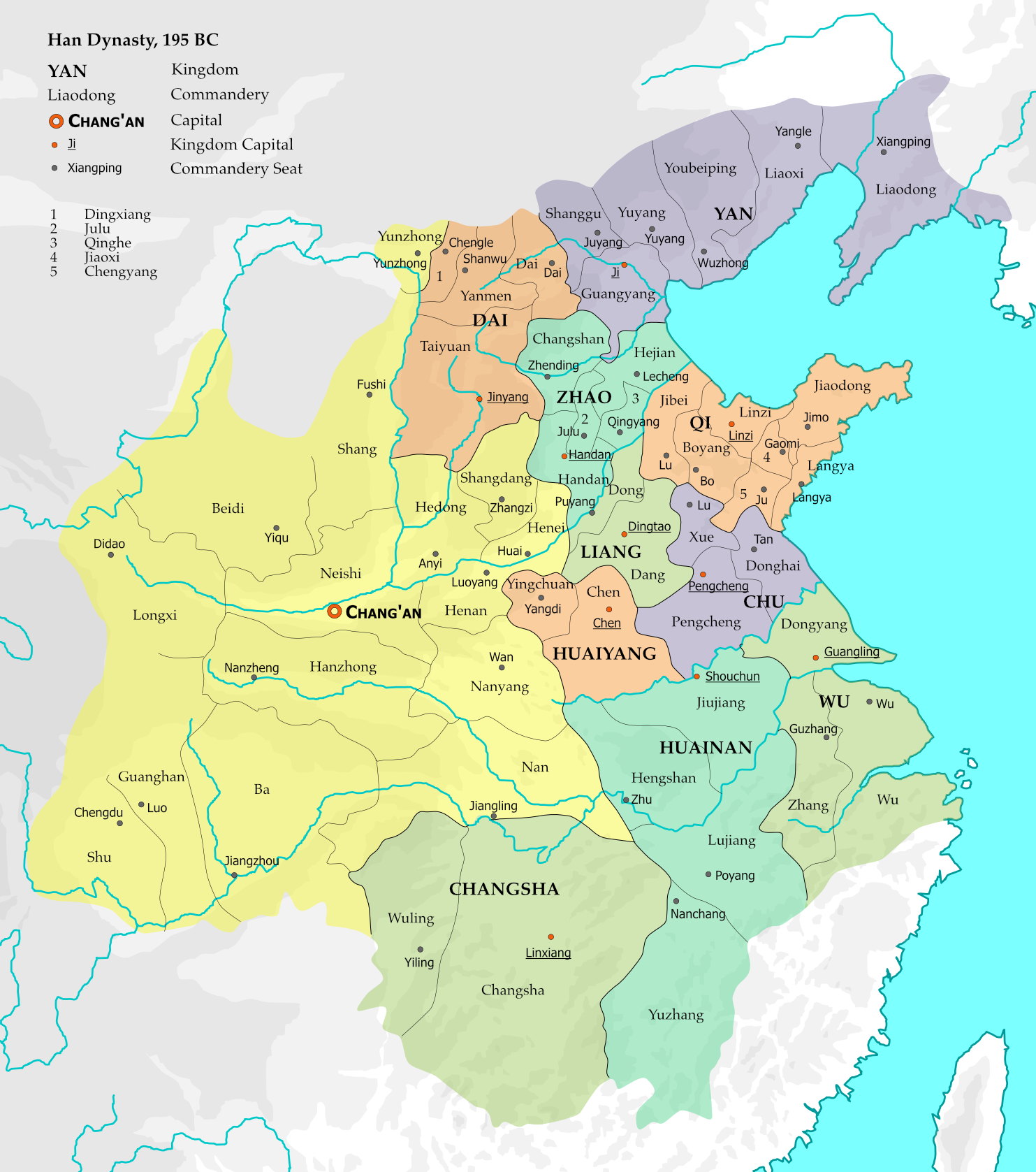
The Han dynasty (, ; ) was an imperial dynasty of China (202 BC – 9 AD, 25–220 AD), established by Liu Bang (Emperor Gao) and ruled by the House of Liu. The dynasty was preceded by the short-lived Qin dynasty (221–207 BC) and a warring interregnum known as the ChuHan contention (206–202 BC), and it was succeeded by the Three Kingdoms period (220–280 AD). The dynasty was briefly interrupted by the Xin dynasty (9–23 AD) established by usurping regent Wang Mang, and is thus separated into two periods—the Western Han (202 BC – 9 AD) and the Eastern Han (25–220 AD). Spanning over four centuries, the Han dynasty is considered a golden age in Chinese history, and it has influenced the identity of the Chinese civilization ever since. Modern China's majority ethnic group refers to themselves as the "Han people", the Sinitic language is known as "Han language", and the written Chinese is referred to as "Han characters". The emperor was at the pinnacle of ... [...More Info...] [...Related Items...] OR: [Wikipedia] [Google] [Baidu] |


_bridge%2C_entrance%2C_circa_1877_-_DPLA_-_d729e9efdd48d34d1fce20fb80c6bd89.jpeg)


