|
Electoral Districts Of The Palestinian National Authority
The 16 Governorates of the Palestinian National Authority are divided into 16 electoral regions (''Aqdya'', singular – ''qadaa''). (Capitals of districts are in parentheses) Jerusalem Governorate: *Jerusalem District (Jerusalem) Bethlehem Governorate: * Bethlehem District (Bethlehem) Deir Al-Balah Governorate: * Deir Al-Balah District (Deir Al-Balah) Gaza Governorate: *Gaza District (Gaza City) Hebron Governorate: * Hebron District (Hebron) Jenin Governorate: *Jenin District (Jenin) Jericho Governorate: * Jericho District (Jericho) Khan Yunis Governorate: * Khan Younis District (Khan Younis) Nablus Governorate: * Nablus District (Nablus) North Gaza Governorate: *North Gaza (Jabalya) Qalqilya Governorate: * Qalqilya District (Qalqilya) Rafah Governorate: * Rafah District (Rafah) Ramallah and Al-Bireh Governorate: *Ramallah and Al-Bireh District (Ramallah) Salfit Governorate: * Salfit District (Salfit) Tubas Governorate: * Tubas District (Tubas) Tulkarm Governorate: ... [...More Info...] [...Related Items...] OR: [Wikipedia] [Google] [Baidu] |
Governorates Of The Palestinian National Authority
The Governorates of Palestine are the administrative divisions of the State of Palestine. After the signing of the Oslo Accords, the Israeli-occupied West Bank and Gaza Strip were divided into three areas ( Area A, Area B, and Area C) and 16 governorates under the jurisdiction of the Palestinian National Authority. Since 2007, there have been two governments claiming to be the legitimate government of the Palestinian National Authority, one based in the West Bank and one based in the Gaza Strip. List West Bank Gaza Strip See also * ISO 3166-2:PS *List of regions of Palestine by Human Development Index This is a list of regions of the State of Palestine by Human Development Index as of 2019. Trends by UNDP reports (international HDI) Human Development Index (by UN Method) of Palestinian Governorates since 2004. See also * Demographics ... References {{Articles on first-level administrative divisions of Asian countries * Palestine, State of ... [...More Info...] [...Related Items...] OR: [Wikipedia] [Google] [Baidu] |
Khan Younis
Khan Yunis ( ar, خان يونس, also spelled Khan Younis or Khan Yunus; translation: ''Caravansary fJonah'') is a city in the southern Gaza Strip. According to the Palestinian Central Bureau of Statistics, Khan Yunis had a population of 142,637 in 2007 and 202,000 in 2010 and 350,000 in 2012. decreasing in the 1931 census to 3811, in 717 houses in the urban areaMills, 1932, p4/ref> and 3440 in 566 houses in the suburbs.Mills, 1932, p5/ref> In the 1945 statistics Khan Yunis had a population of 11,220, 11,180 Muslims and 40 Christians,Department of Statistics, 1945, p31/ref> with 2,302 (urban) and 53,820 (rural) dunams of land, according to an official land and population survey. Of this, 4,172 dunams were plantations and irrigable land, 23,656 used for cereals, while 1,847 dunams were built-up land. During the Nazi occupation of the Dodecanese, many Greeks from Dodecanese islands such as Kastelorizo sought refuge in the nearby Nuseirat camp. 1948–1967 During the ... [...More Info...] [...Related Items...] OR: [Wikipedia] [Google] [Baidu] |
Tubas Governorate
The Tubas Governorate ( ar, محافظة طوباس, Muḥāfaẓat Ṭūbās) is an administrative district of the Palestine in the northeastern West Bank. Its district capital or ''muhfaza'' is the city of Tubas. In 2007, the population was 50,267, . raising to 60,927 in 2017. Localities There are 23 localities located within the governorate's jurisdiction.Cities * |
Salfit
Salfit ( ar, سلفيت) pronounced "Salfeet" is a Palestinian city in the central West Bank, and the capital of the Salfit Governorate of the State of Palestine. Salfit is located at an altitude of , adjacent to the Israeli settlement of Ariel. According to the Palestinian Central Bureau of Statistics (PCBS), Salfit had a population of 10,911 in 2017. and was one of many large commercial villages in the area that served a mediating role between the administrative center of Nablus and the smaller villages. In 1882 the PEF's ''Survey of Western Palestine'', Salfit was described as "a large village, on high ground, with olive groves round it, and a pool to the east. It is apparently an ancient site with rock-cut tombs." It further noted that there were two springs to the west of the village. By 1916, towards the end of Ottoman rule in Palestine, Salfit was one of the two largest villages in the District of Nablus that produced olive oil. At the time there were tensions between the r ... [...More Info...] [...Related Items...] OR: [Wikipedia] [Google] [Baidu] |
Salfit Governorate
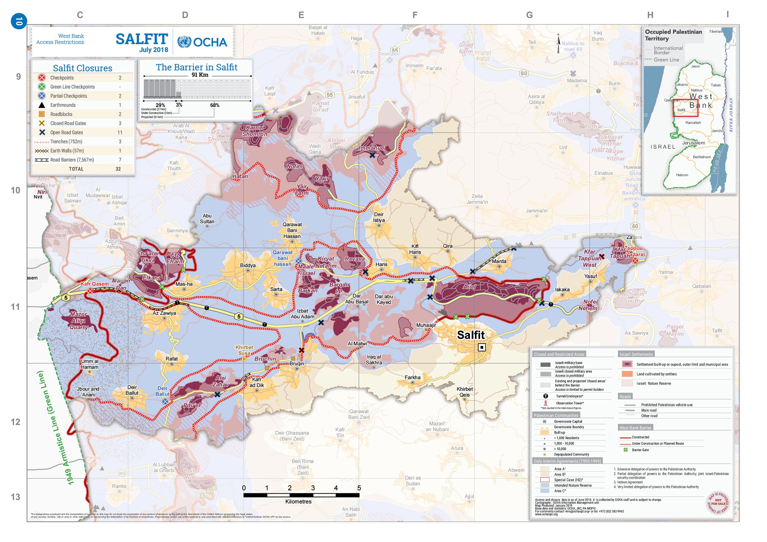
Salfit governorate ( ar, محافظة سلفيت) is one of 16 Governorates of the Palestinian National Authority. It is located in the northwestern West Bank, held under Israeli occupation, bordered by the governorates of Ramallah and al-Bireh to the south, Nablus to the east and Qalqilya in the north as well as, Israel to the west. Its district capital and largest city is Salfit. According to the Palestinian Central Bureau of Statistics (PCBS), the governorate had a population of 75,444 inhabitants in mid-year 2017. In the PCBS's census in 1997, which registered 46,671 residents, refugees accounted for 7.7% of the total population. There were 37,613 male residents and 36,143 females. Location It extends from the village of Za'tara in the east and ends in the city of Kafr Qasim in Israel. It is bordered by the Nablus governorate on the eastern side; the governorates of Nablus and Qalqiliya on the northern side; to the south Ramallah and Al-Bireh; and the Green Line from the ... [...More Info...] [...Related Items...] OR: [Wikipedia] [Google] [Baidu] |
Ramallah
Ramallah ( , ; ar, رام الله, , God's Height) is a Palestinian city in the central West Bank that serves as the ''de facto'' administrative capital of the State of Palestine. It is situated on the Judaean Mountains, north of Jerusalem, at an average elevation of above sea level, adjacent to al-Bireh. Ramallah has buildings containing masonry from the period of Herod the Great, but no complete building predates the Crusades of the 11th century. The modern city was founded during the 16th century by the Hadadeens, an Arab Christian clan descended from Ghassanids. In 1517, the city was incorporated into the Ottoman Empire, and in 1920, it became part of British Mandatory Palestine after it was captured by the United Kingdom during World War I. The 1948 Arab–Israeli War saw the entire West Bank, including Ramallah, occupied and annexed by Transjordan. Ramallah was later captured by Israel in the 1967 Six-Day War. Since the 1995 Oslo Accords, Ramallah has been go ... [...More Info...] [...Related Items...] OR: [Wikipedia] [Google] [Baidu] |
Ramallah And Al-Bireh Governorate
The Ramallah and al-Bireh Governorate ( ar, محافظة رام الله والبيرة ') is one of 16 governorates of Palestine. It covers a large part of the central West Bank, on the northern border of the Jerusalem Governorate. Its district capital or ''muhfaza'' (seat) is the city of al-Bireh. According to the Palestinian Central Bureau of Statistics (PCBS), the district had a population of 279,730 in 2007. Its governor is Dr Laila Ghannam, the first female governor. Localities According to PCBS, the governorate has 78 localities, including refugee camps, in its jurisdiction. 13 localities have the status of municipality. Cities *Al-Bireh: 45,975 *Ramallah: 38,998 *Beitunia: 26,604 *Rawabi: 710 Municipalities The following localities in the Ramallah and al-Bireh Governorate have populations over 5,000. *Bani Zeid * Bani Zeid al-Sharqiya * Beit Liqya * Bir Zeit * Deir Ammar *Deir Dibwan *Deir Jarir *al-Ittihad *Kharbatha al-Misbah *al-Mazra'a ash-Sharqiya *Ni'lin *Silwa ... [...More Info...] [...Related Items...] OR: [Wikipedia] [Google] [Baidu] |
Rafah
Rafah ( ar, رفح, Rafaḥ) is a Palestinian city in the southern Gaza Strip. It is the district capital of the Rafah Governorate, located south of Gaza City. Rafah's population of 152,950 (2014) is overwhelmingly made up of former Palestinian refugees. When Israel withdrew from the Sinai in 1982, Rafah was split into a Gazan part and an Egyptian part, dividing families, separated by barbed-wire barriers. The core of the city was destroyed by Israel''Razing Rafah — Mass Home Demolitions in the Gaza Strip'' pp. 27–28 and 52–66 (PDF text version) o [...More Info...] [...Related Items...] OR: [Wikipedia] [Google] [Baidu] |
Rafah Governorate
The Rafah Governorate ( ar, محافظة رفح ') is a Governorate of Palestine in the southernmost portion of the Gaza Strip. Its district capital or ''muhfaza'' is the city of Rafah located on the border with Egypt. According to the Palestinian Central Bureau of Statistics the governorate had a population of 171,363 in mid-year 2006. It contains the closed down Yasser Arafat International Airport. Localities * al-Bayuk * al-Mawasi * Kherbit al-Adas * al-Qarya as-Suwaydiya * Rafah (capital) * Shokat as-Sufi Shokat as-Sufi is a Palestinian town in the southern Gaza Strip, south of Rafah and adjacent to the inoperable Yasser Arafat International Airport. It is one of the poorest localities in the Gaza Strip, and has underdeveloped infrastructure. Accor ... Refugee camps * Tel al-Sultan * Rafah Camp References * http://www.lib.utexas.edu/maps/middle_east_and_asia/gaza_strip_1999.jpg * http://www.pcbs.gov.ps/Portals/_pcbs/populati/pop16.aspx {{Coord, 31.3, N, 34.25, ... [...More Info...] [...Related Items...] OR: [Wikipedia] [Google] [Baidu] |
Qalqilya
Qalqilya or Qalqiliya ( ar, قلقيلية, Qalqīlyaḧ) is a Palestinian city in the West Bank which serves as the administrative center of the Qalqilya Governorate of the State of Palestine. In the 2007 census, the city had a population of 41,739. Qalqilya is surrounded by the Israeli West Bank wall, with a narrow gap in the east controlled by the Israeli military and a tunnel to the Palestinian town of Hableh. Qalqilya is under the administration of the Palestinian National Authority (as part of Area A), while remaining under Israeli military occupation. Oranges are a major part of the city's economy. Etymology Qalqilya was known as ''Calecailes'' in the Roman period, and ''Calcelie'' in the Frankish sources from the early Medieval times. The word "Qalqilya" might be derived from a Canaanite term which means "rounded stones or hills".According to E.H. Palmer, the name came from "a type of pomegranate", or "gurgling of water".Palmer, 1881, p183/ref> History The vicinity of ... [...More Info...] [...Related Items...] OR: [Wikipedia] [Google] [Baidu] |
Qalqilya Governorate
The Qalqilya Governorate or Qalqiliya Governorate () is an administrative area of Palestine in the northwestern West Bank. Its capital or ''muhfaza'' (seat) is the city of Qalqilya that borders the Green Line. Localities Municipalities * Azzun * Hableh * Qalqilya * Kafr Thulth Towns and villages * Azzun 'Atma * Baqah * Baqat al-Hatab * Beit Amin * Falamya * Hajjah * Immatain * Islah * Jayyous * Jinsafut * Jit * Kafr Laqif * Kafr Qaddum * an Nabi Elyas * Ras Atiya * Sanniriya Sanniriya ( ar, صنّيريّه) is a Palestinian town in the Qalqilya Governorate in the western area of the West Bank, located south of Qalqilya and southwest of Nablus. According to the Palestinian Central Bureau of Statistics, the village ha ... * Fara'ata References {{Coord, 32, 11, 9, N, 35, 3, 57, E, display=title, region:PS-QQA Governorates of the Palestinian National Authority in the West Bank ... [...More Info...] [...Related Items...] OR: [Wikipedia] [Google] [Baidu] |
Jabalya
Jabalia also Jabalya ( ar, جباليا) is a Palestinian city located north of Gaza City. It is under the jurisdiction of the North Gaza Governorate, in the Gaza Strip. According to the Palestinian Central Bureau of Statistics, Jabalia had a population of 82,877 in mid-2006. The Jabalia refugee camp is adjacent to the city to the north. The nearby town of Nazla is a part of the Jabalia municipality. The city is currently ruled by a Hamas administration. Archaeology A large cemetery dating to the 8th century CE was found near Jabalia. The workmanship indicates that the Christian community in Gaza was still very much in existence in the early Islamic era of rule in Palestine, and capable of artistic achievements. The remains of the pavement spared by the iconoclasts show depictions of wild game, birds, and country scenes. The late dating of the mosaic pavement proves that the intervention of the iconoclasts, after 750, is later than previously thought and is associated with Abbasi ... [...More Info...] [...Related Items...] OR: [Wikipedia] [Google] [Baidu] |


