|
Balsas River (Panama)
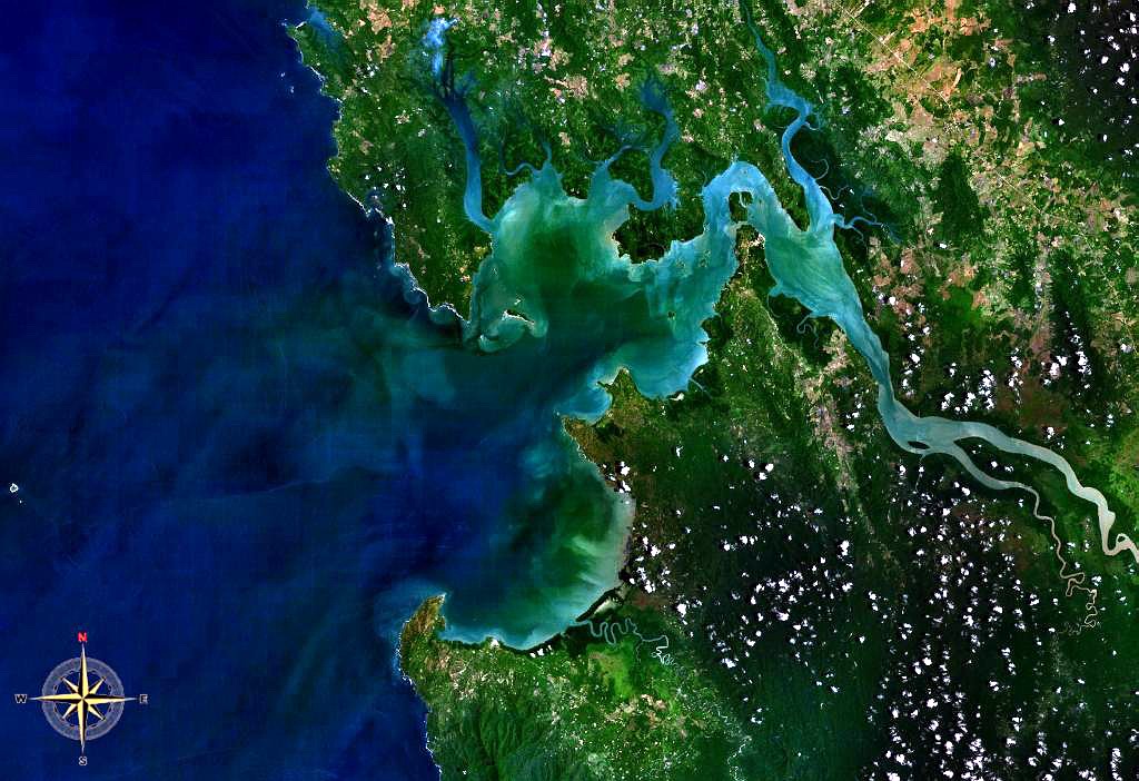
The Balsas River ( es, Rio Balsas) or Rio Tucutí is a river of eastern Panama. Geography The Balsas is a tributary of the Tuira (or Darien) river. It rises on the border with Colombia and flows north and then northeast to its confluence with the Tuira. Its headwaters flow through the Darién National Park. A 1903 report on Panama listed the Balsas as one of the more important rivers of the territory of Darien, then in Panamá Province. The report said that gold was obtained from the Balsas. The Köppen climate classification is Tropical Savannah. The region has an average temperature of and average precipitation of per year. Annual runoff is between . It rains on about 150 days each year. The watershed of the Balsas covers . Average flow at its mouth is . The waters of the Balsa River are more turbid than the waters of the Tuira River, indicating greater amounts of erosion in the Balsa basin. The mouth of the Balsas River has several islets formed by sediment, some with gro ... [...More Info...] [...Related Items...] OR: [Wikipedia] [Google] [Baidu] |
Tuira River
The Tuira River is located in the Darién Province of eastern Panama. It flows into the Bay of San Miguel at the province capital of La Palma. It is the largest river in Panama, and one of its tributaries, the Chucunaque River, is the longest river in Panama. The river starts in highlands of Darien, and runs south/southeast, and then north and west. It runs past villages as it flows downstream including Matuganti, Sobiaquirú, El Balsal, Boca de Cupe, Capetí, Yape, Aruza, Unión Chocó, Vista Alegre, and Pinogana.(30 April 2008)Panama: Weary repatriation Relief Web It meets the Chucunaque River at El Real de Santa María and then flows northwest towards La Palma.Tuira River Brittanica.com, Retrieved 30 November 2022 Via the Chucunaque, one can reach |
Panama
Panama ( , ; es, link=no, Panamá ), officially the Republic of Panama ( es, República de Panamá), is a transcontinental country spanning the southern part of North America and the northern part of South America. It is bordered by Costa Rica to the west, Colombia to the southeast, the Caribbean Sea to the north, and the Pacific Ocean to the south. Its capital and largest city is Panama City, whose metropolitan area is home to nearly half the country's million people. Panama was inhabited by indigenous tribes before Spanish colonists arrived in the 16th century. It broke away from Spain in 1821 and joined the Republic of Gran Colombia, a union of Nueva Granada, Ecuador, and Venezuela. After Gran Colombia dissolved in 1831, Panama and Nueva Granada eventually became the Republic of Colombia. With the backing of the United States, Panama seceded from Colombia in 1903, allowing the construction of the Panama Canal to be completed by the United States Army Corps of En ... [...More Info...] [...Related Items...] OR: [Wikipedia] [Google] [Baidu] |
Colombia
Colombia (, ; ), officially the Republic of Colombia, is a country in South America with insular regions in North America—near Nicaragua's Caribbean coast—as well as in the Pacific Ocean. The Colombian mainland is bordered by the Caribbean Sea to the north, Venezuela to the east and northeast, Brazil to the southeast, Ecuador and Peru to the south and southwest, the Pacific Ocean to the west, and Panama to the northwest. Colombia is divided into 32 departments and the Capital District of Bogotá, the country's largest city. It covers an area of 1,141,748 square kilometers (440,831 sq mi), and has a population of 52 million. Colombia's cultural heritage—including language, religion, cuisine, and art—reflects its history as a Spanish colony, fusing cultural elements brought by immigration from Europe and the Middle East, with those brought by enslaved Africans, as well as with those of the various Amerindian civilizations that predate colonization. Spanish is th ... [...More Info...] [...Related Items...] OR: [Wikipedia] [Google] [Baidu] |
Darién National Park
Darién National Park ( es, Parque Nacional Darién) is a World Heritage Site in Panama. It is about 325 kilometers from Panama City, and is the most extensive of all national parks of Panama and is one of the most important world heritage sites in Central America. The Darién National Park is a natural bridge spanning North and South America. In 1972 an area of became part of the Alto Darién Protection Forest. In 1980 the area was declared a National Park. In 1983 an area of became a UNESCO biosphere reserve. The park covers . It is located in southernmost Panama in Darién province and its southern boundary extends along 90% of the Panama-Colombian border. It lies between the range, which parallels t ... [...More Info...] [...Related Items...] OR: [Wikipedia] [Google] [Baidu] |
Darién Province
Darién (, , ) is a province in Panama whose capital city is La Palma. With an area of , it is located at the eastern end of the country and bordered to the north by the province of Panamá and the region of Kuna Yala. To the south, it is bordered by the Pacific Ocean and Colombia. To the east, it borders Colombia; to the west, it borders the Pacific Ocean and the province of Panama. The area surrounding the border with Colombia is known as the Darién Gap, a large swath of undeveloped swampland and forest. With no roads, it is the missing link of the Pan-American Highway. Place names The name originates from the language spoken by the Cueva, an Indigenous tribe destroyed by the white European conquistadors during the 16th century. The Tanela River, which flows toward Atrato, was Hispanicized to Darién; the region and its communities took the same name. Santa María la Antigua del Darién, the first city founded in Tierra Firme, also took its name from the river. Subsequentl ... [...More Info...] [...Related Items...] OR: [Wikipedia] [Google] [Baidu] |
Panamá Province
Panamá is a province of Panama. It is the location of the national capital Panama City, which also serves as the provincial capital. The governor of the province is Judy Meana, appointed by President Laurentino Cortizo and sworn in on 16 April 2020. Administrative divisions Panamá Province is now divided into 6 ''distritos'' (districts) and subdivided into 55 '' corregimientos''. The five former districts west of the Panama Canal were split off to form Panamá Oeste Province Panamá Oeste (; "West Panama" in English) is the newest province in Panama. It was created from the five districts of Panamá Province west of the Panama Canal The Panama Canal ( es, Canal de Panamá, link=no) is an artificial waterway i ... on 1 January 2014. 1 These ''corregimientos'' represent as Panama City 2 These ''corregimientos'' represent as San Miguelito City References {{DEFAULTSORT:Panama Province Provinces of Panama ... [...More Info...] [...Related Items...] OR: [Wikipedia] [Google] [Baidu] |
Köppen Climate Classification
The Köppen climate classification is one of the most widely used climate classification systems. It was first published by German-Russian climatologist Wladimir Köppen (1846–1940) in 1884, with several later modifications by Köppen, notably in 1918 and 1936. Later, the climatologist Rudolf Geiger (1894–1981) introduced some changes to the classification system, which is thus sometimes called the Köppen–Geiger climate classification system. The Köppen climate classification divides climates into five main climate groups, with each group being divided based on seasonal precipitation and temperature patterns. The five main groups are ''A'' (tropical), ''B'' (arid), ''C'' (temperate), ''D'' (continental), and ''E'' (polar). Each group and subgroup is represented by a letter. All climates are assigned a main group (the first letter). All climates except for those in the ''E'' group are assigned a seasonal precipitation subgroup (the second letter). For example, ''Af'' indi ... [...More Info...] [...Related Items...] OR: [Wikipedia] [Google] [Baidu] |
Ochroma Lagopus
''Ochroma pyramidale'', commonly known as the balsa tree, is a large, fast-growing tree native to the Americas. It is the sole member of the genus ''Ochroma''. The tree is famous for its wide usage in woodworking, with the name ''balsa'' being the Spanish word for "raft." A deciduous angiosperm, ''Ochroma pyramidale'' can grow up to 30 m tall, and is classified as a hardwood despite the wood itself being very soft; it is the softest commercial hardwood and is widely used because of its light weight. Biology Balsa on Bota Hill, Limbe Botanical Garden, Cameroon">Limbe_Botanical_Garden.html" ;"title="Bota Hill, Limbe Botanical Garden">Bota Hill, Limbe Botanical Garden, Cameroon A member of the mallow family, ''Ochroma pyramidale'' is native from southern Mexico to southern Brazil, but can now be found in many other countries (Papua New Guinea, Indonesia, Thailand, Solomon Islands). It is a pioneer plant, which establishes itself in clearings in forests, either man-mad ... [...More Info...] [...Related Items...] OR: [Wikipedia] [Google] [Baidu] |
Gil González Dávila
Gil González Dávila or Gil González de Ávila (b. 1480 – 21 April 1526) was a Spanish conquistador and the first European to explore present-day Nicaragua. Early career González Dávila first appears in historical records in 1508, when he received a royal commission to examine accounts and tax records of estates. He probably traveled soon afterward to Santo Domingo for his assignment, and to establish himself. In 1511, from Valladolid, Spain, he was given the title of Accountant of Hispaniola or contador. By 1514, the Hispaniola treasury staff put in place by Ferdinand, included Gil, who had replaced Cristóbal de Cuéllar as contador, Miguel de Pasamonte, who had been named treasurer general of the Indies in April 1508, and Juan Martinez de Ampies as factor. His enhanced position enabled him to become a teacher and he soon had an estate with over 200 Indian slaves. In 1518, González delivered a report to Charles V which was highly critical of the colonial management ... [...More Info...] [...Related Items...] OR: [Wikipedia] [Google] [Baidu] |
Acla
Acla was a Spanish colonial town founded by order of the Governor of Castilla de Oro, Pedrarias Dávila, in 1515. It was located on the central coastline of the modern-day Guna Yala, to the northeast of Panamá. The town's name means ''bones of men'' in the indigenous language. The name comes from the large number of bones strewn about the nearby plains, which supposedly came from the conflicts between two indigenous brothers who fought to become chiefs of the region. The town was established principally to be the Caribbean anchor of a trail that was planned to lead to a future town on the Gulf of San Miguel on the Pacific Ocean, which had recently been discovered by Vasco Núñez de Balboa. This town is mostly famous because it was the site of the judgement and decapitation of Núñez de Balboa in 1519 at the hands of Governor Dávila. Due to the unhealthy nature of the climate and terrain surrounding the town, and especially after the founding of Panama City Panama ... [...More Info...] [...Related Items...] OR: [Wikipedia] [Google] [Baidu] |
Bay Of San Miguel
The Bay of San Miguel () is a bay of the Gulf of Panama, located on the Pacific coast of Darién Province in eastern Panama. The bay is located at . It is fed by the Tuira River The Tuira River is located in the Darién Province of eastern Panama. It flows into the Bay of San Miguel at the province capital of La Palma. It is the largest river in Panama, and one of its tributaries, the Chucunaque River, is the longest .... At its southern end is Cape Garachiné (also known as Point Garachina), and at its northern end is Punta San Lorenzo (a.k.a. Cape Gardo). See also * San Miguel San Miguel, Panama Landforms of Darién Province Gulf of Panama Panamanian coasts of the Pacific Ocean {{Darién-geo-stub ... [...More Info...] [...Related Items...] OR: [Wikipedia] [Google] [Baidu] |


