|
Aramus, Armenia
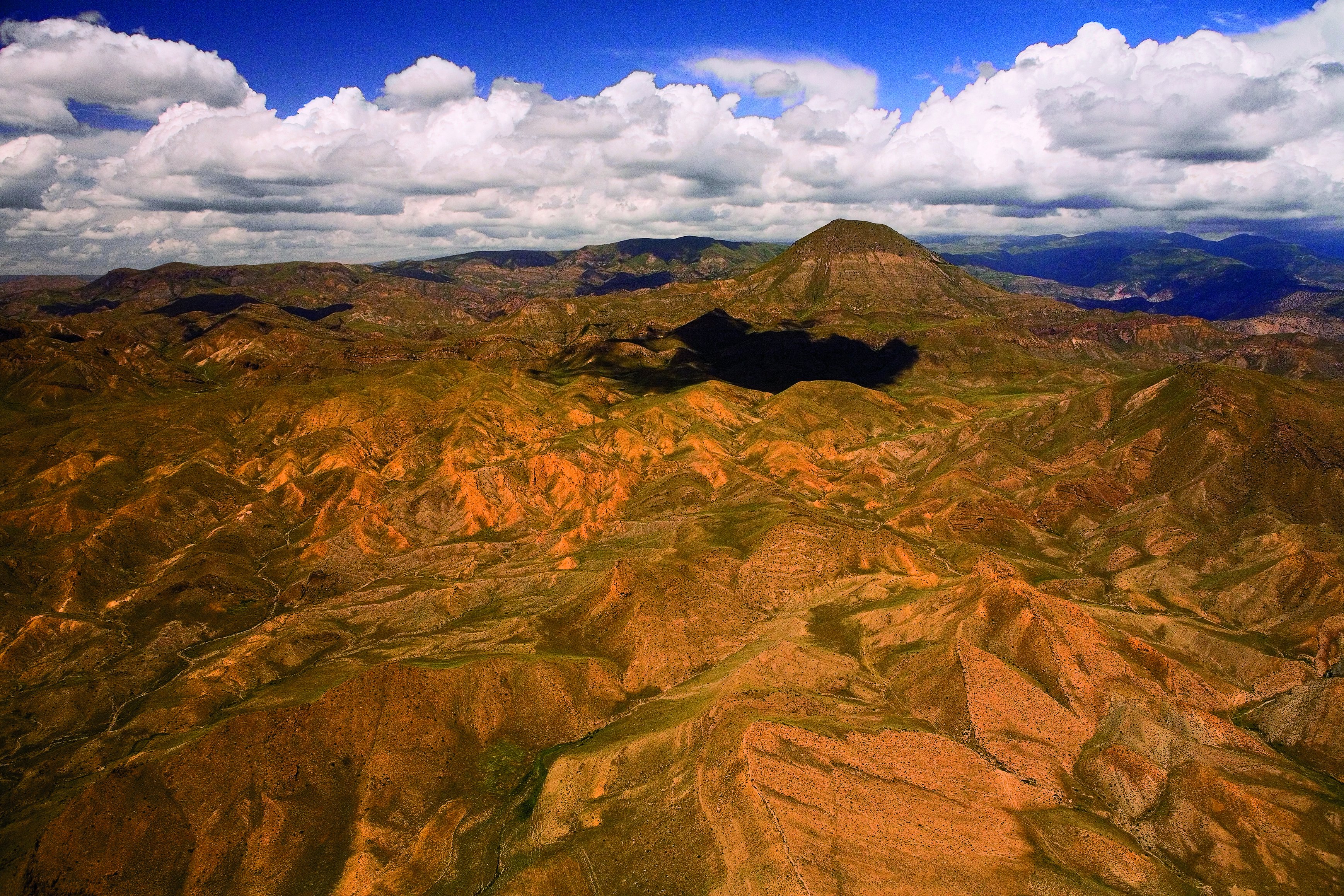
Aramus ( hy, Արամուս) is a village in the Kotayk Province of Armenia. Its located at 43 km of the Getar river and 25 km of the armenian capital, Yerevan. Etymology The name of the village came from a myth during the ancient times of the kingdom of Armenia. Through this era, an Armenian hero called Ara Geghetsik (translated as "Ara the Handsome") fought a battle in the village's area against the mythical Assyrian queen Semiramis. During the battle, Ara Geghetsik was wounded in the shoulder. Because of that wound, the place was called ''Aram's shoulder (in armenian "Aramy Usy")'' and then, after linguistics evolutions of centuries, the name changed to Aramus. Topography and Climate The village of Aramus is part of the Kotayk Province of the historic Ayrarat province of Greater Armenia . Nowadays, it is a part of the Kotayk region, 25 km away from the city of Yerevan. Its at east of the Yerevan-San highway. The nearest city is Abovyan. Aramus is located ... [...More Info...] [...Related Items...] OR: [Wikipedia] [Google] [Baidu] |
Armenia
Armenia (), , group=pron officially the Republic of Armenia,, is a landlocked country in the Armenian Highlands of Western Asia.The UNbr>classification of world regions places Armenia in Western Asia; the CIA World Factbook , , and ''Oxford Reference Online'' also place Armenia in Asia. It is a part of the Caucasus region; and is bordered by Turkey to the west, Georgia to the north, the Lachin corridor (under a Russian peacekeeping force) and Azerbaijan to the east, and Iran and the Azerbaijani exclave of Nakhchivan to the south. Yerevan is the capital, largest city and the financial center. Armenia is a unitary, multi-party, democratic nation-state with an ancient cultural heritage. The first Armenian state of Urartu was established in 860 BC, and by the 6th century BC it was replaced by the Satrapy of Armenia. The Kingdom of Armenia reached its height under Tigranes the Great in the 1st century BC and in the year 301 became the first state in the world to adopt ... [...More Info...] [...Related Items...] OR: [Wikipedia] [Google] [Baidu] |
Gegham Mountains
Gegham mountains (or Gegham Ridge, ISO 9985: Geġam), hy, Գեղամա լեռնաշղթա (''Geghama lernasheghta'') are a range of mountains in Armenia. The range is a tableland-type watershed basin of Sevan Lake from east, inflows of rivers Araks and Hrazdan from north and west, Azat and Vedi rivers from south-west and Arpachai river from south. The average elevation of the Gegham mountain range is near 2500m. The range is of volcanic origin including many extinct volcanoes. The range is 70 km length and 48 km width, and stretch between Lake Sevan and the Ararat plain. The highest peak of the Gegham mountains is the Azhdahak, at 3597m. They are formed by a volcanic field, containing Pleistocene-to-Holocene lava domes and cinder cones. The highland reaches a height of 1800–2000m up to 3000m in the dividing ridge. Geological history Volcanism in Armenia and in the Gegham mountains is related to mantle processes accompanying, but not necessarily related to the coll ... [...More Info...] [...Related Items...] OR: [Wikipedia] [Google] [Baidu] |
Urartu
Urartu (; Assyrian: ',Eberhard Schrader, ''The Cuneiform inscriptions and the Old Testament'' (1885), p. 65. Babylonian: ''Urashtu'', he, אֲרָרָט ''Ararat'') is a geographical region and Iron Age kingdom also known as the Kingdom of Van, centered around Lake Van in the historic Armenian Highlands. The kingdom rose to power in the mid-9th century BC, but went into gradual decline and was eventually conquered by the Iranian Medes in the early 6th century BC. Since its re-discovery in the 19th century, Urartu, which is commonly believed to have been at least partially Armenian-speaking, has played a significant role in Armenian nationalism. Names and etymology Various names were given to the geographic region and the polity that emerged in the region. * Urartu/Ararat: The name ''Urartu'' ( hy, Ուրարտու; Assyrian: '; Babylonian: ''Urashtu''; he, אֲרָרָט ''Ararat'') comes from Assyrian sources. Shalmaneser I (1263–1234 BC) recorded a campaign in wh ... [...More Info...] [...Related Items...] OR: [Wikipedia] [Google] [Baidu] |
Bronze Age
The Bronze Age is a historic period, lasting approximately from 3300 BC to 1200 BC, characterized by the use of bronze, the presence of writing in some areas, and other early features of urban civilization. The Bronze Age is the second principal period of the three-age system proposed in 1836 by Christian Jürgensen Thomsen for classifying and studying ancient societies and history. An ancient civilization is deemed to be part of the Bronze Age because it either produced bronze by smelting its own copper and alloying it with tin, arsenic, or other metals, or traded other items for bronze from production areas elsewhere. Bronze is harder and more durable than the other metals available at the time, allowing Bronze Age civilizations to gain a technological advantage. While terrestrial iron is naturally abundant, the higher temperature required for smelting, , in addition to the greater difficulty of working with the metal, placed it out of reach of common use until the end o ... [...More Info...] [...Related Items...] OR: [Wikipedia] [Google] [Baidu] |
Dissolution Of The Soviet Union
The dissolution of the Soviet Union, also negatively connoted as rus, Разва́л Сове́тского Сою́за, r=Razvál Sovétskogo Soyúza, ''Ruining of the Soviet Union''. was the process of internal disintegration within the Soviet Union (USSR) which resulted in the end of the country's and its federal government's existence as a sovereign state, thereby resulting in its constituent republics gaining full sovereignty on 26 December 1991. It brought an end to General Secretary Mikhail Gorbachev's (later also President) effort to reform the Soviet political and economic system in an attempt to stop a period of political stalemate and economic backslide. The Soviet Union had experienced internal stagnation and ethnic separatism. Although highly centralized until its final years, the country was made up of fifteen top-level republics that served as homelands for different ethnicities. By late 1991, amid a catastrophic political crisis, with several republics alre ... [...More Info...] [...Related Items...] OR: [Wikipedia] [Google] [Baidu] |
1988 Armenian Earthquake
The 1988 Armenian earthquake, also known as the Spitak earthquake ( hy, Սպիտակի երկրաշարժ, ), occurred on December 7 at with a surface wave magnitude of 6.8 and a maximum MSK intensity of X (''Devastating''). The shock occurred in the northern region of Armenia (then part of the Soviet Union) which is vulnerable to large and destructive earthquakes and is part of a larger active seismic belt that stretches from the Alps to the Himalayas. Activity in the area is associated with tectonic plate boundary interaction and the source of the event was slip on a thrust fault just to the north of Spitak. The complex incident ruptured multiple faults, with a strike-slip event occurring shortly after the initiation of the mainshock. Between 25,000 and 50,000 were killed and up to 130,000 were injured. Seismologists thoroughly studied the effects of the Spitak event, including the mainshock and aftershock fault rupture mechanisms, and were on site setting up temporary seism ... [...More Info...] [...Related Items...] OR: [Wikipedia] [Google] [Baidu] |
Yerevan State University
Yerevan State University (YSU; hy, Երևանի Պետական Համալսարան, ԵՊՀ, ''Yerevani Petakan Hamalsaran''), also simply University of Yerevan, is the oldest continuously operating public university in Armenia. Founded in 1919, it is the largest university in the country. It is thus informally known as Armenia's "mother university" (Մայր ԲՈւՀ, ''Mayr Buh''). Of its 3,150 employees, 1,190 comprise the teaching staff, which includes 25 academicians, 130 professors, 700 docents (associate professors), and 360 assistant lecturers. The university has 400 researchers, 1,350 post-graduate students, and 8,500 undergraduates, including 300 students from abroad. Instruction is in Armenian, but instruction in Russian or English for foreign students is available as needed. The academic year is from September 1 through June 30. According to University Ranking by Academic Performance (URAP), it was the top-ranked university in Armenia and the 954th in the world in 2 ... [...More Info...] [...Related Items...] OR: [Wikipedia] [Google] [Baidu] |
Hatis
Hatis ( hy, Հատիս), formerly known as Kyankyan, is a village in the Kotayk Province of Armenia. The village is populated by mostly Armenians with Kurds being a minority (about 8%). See also *Kotayk Province Kotayk ( hy, Կոտայք, ), is a province ('' marz'') of Armenia. It is located at the central part of the country. Its capital is Hrazdan and the largest city is Abovyan. It is named after the Kotayk canton of the historic Ayrarat province ... References * * Populated places in Kotayk Province Kurdish settlements in Armenia {{Kotayk-geo-stub ... [...More Info...] [...Related Items...] OR: [Wikipedia] [Google] [Baidu] |
Abovyan
Abovyan or Abovian ( hy, Աբովյան), is a town and urban municipal community in Armenia within the Kotayk Province. It is located northeast of Yerevan and southeast of the province centre Hrazdan. As of the 2011 census, the population of the town is 43,495, down from 59,000 reported at the 1989 census. Currently, the town has an approximate population of 44,900 as per the 2020 official estimate. With a motorway and railway running through the city connecting Yerevan with the areas of the northeast, Abovyan is considered a satellite city of the Armenian capital. Therefore, Abovyan is generally known as the "northern gate of Yerevan". Abovyan covers an area of around . Etymology The site of present-day Abovyan was previously occupied by a small village known as ''Elar''. One folk tradition connects the name Elar with the legend of Ara the Handsome: the Assyrian queen Semiramis is said to have brought the body of the murdered Armenian king to the village and ordered the inh ... [...More Info...] [...Related Items...] OR: [Wikipedia] [Google] [Baidu] |
Administrative Divisions Of Armenia
Administration may refer to: Management of organizations * Management, the act of directing people towards accomplishing a goal ** Administrative Assistant, traditionally known as a Secretary, or also known as an administrative officer, administrative support specialist, or management assistant is a person whose work consists of supporting management, including executives, using a variety of project management, communication, or organizational skills, while in some cases, in addition, may require specialized knowledge acquired through higher education. ** Administration (government), management in or of government *** Administrative division ** Academic administration, a branch of an academic institution responsible for the maintenance and supervision of the institution ** Arts administration, a field that concerns business operations around an art organization ** Business administration, the performance or management of business operations *** Bachelor of Business Administratio ... [...More Info...] [...Related Items...] OR: [Wikipedia] [Google] [Baidu] |
Greater Armenia
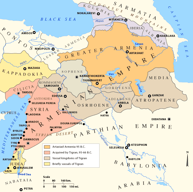
Greater Armenia ( hy, Մեծ Հայք, translit=Mets Hayk) is the name given to the Armenian state that emerged on the Armenian Highlands during the reign of King Artaxias I at the turn of the 2nd century BC. The term was used to refer principally to the fifteen provinces that made up Armenian kingdoms throughout the classical, late antique, and medieval periods by contemporary Armenian and non-Armenian authors alike. Extent Though its borders were never exactly defined, Greater Armenia usually referred to the stretch of land beginning from the Euphrates River to the west, the region of Artsakh and parts of what are now Azerbaijan and Iranian Azerbaijan to the east, parts of the modern state of Georgia to the north, with its southern boundary rounding the northern tip of Mesopotamia. The Romans referred to it in Latin as ''Armenia Maior'' while the Greek-speaking peoples called it ''Armenia Megale'' (), to differentiate it from Lesser Armenia (''Pok'r Hayk′'', in Latin ... [...More Info...] [...Related Items...] OR: [Wikipedia] [Google] [Baidu] |


.jpg)


%2C_Ara_mountain_in_the_background.jpg)
