Gurio Lamanna on:
[Wikipedia]
[Google]
[Amazon]
Gurio Lamanna (also incorrectly called Gurlamanna) is a doline shaped like a
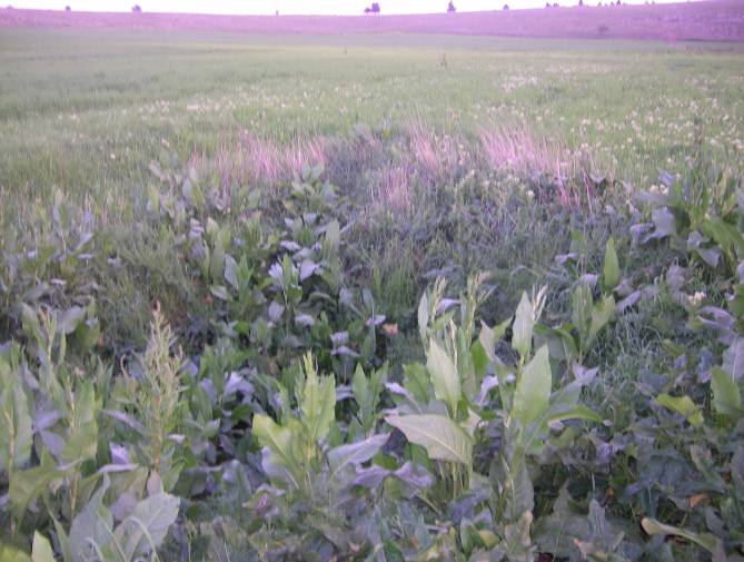
 The whole flat area contains a deep layer of fertile soil, L'intera area piatta contiene un notevole strato di terreno fertile, consequence of the millenary erosion and which is successfully cultivated together with the nearby doline Tre Paduli. Also because of this, the area is different from the stony, arid and difficult to grow
  Close to the doline are the ruins of a small XX century primary school both for children and adults.
 Carmelo Colamonico hypothesized that, initially, there may have been a
coat of arms
A coat of arms is a heraldic visual design on an escutcheon (i.e., shield), surcoat, or tabard (the latter two being outer garments). The coat of arms on an escutcheon forms the central element of the full heraldic achievement, which in its ...
located in the Murge
The Altopiano delle Murge (Italian for "Murge plateau") is a karst topographic plateau of rectangular shape in southern Italy. Most of it lies within Apulia and corresponds with the sub-region known as Murgia or Le Murge. The plateau lies mainl ...
plateau and falling into Gravina in Puglia
Gravina in Puglia (; nap, label= Barese, Gravéine ; la, Silvium; grc, Σιλούϊον, Siloúïon) is a town and ''comune'' of the Metropolitan City of Bari, Apulia, southern Italy.
The word ''gravina'' comes from the Latin ''grava'' or from ...
's territory, on the border with Altamura, Apulia, southern Italy
Italy ( it, Italia ), officially the Italian Republic, ) or the Republic of Italy, is a country in Southern Europe. It is located in the middle of the Mediterranean Sea, and its territory largely coincides with the homonymous geographical ...
. It is "one of the largest karst landforms of the Murge
The Altopiano delle Murge (Italian for "Murge plateau") is a karst topographic plateau of rectangular shape in southern Italy. Most of it lies within Apulia and corresponds with the sub-region known as Murgia or Le Murge. The plateau lies mainl ...
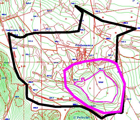
plateau" C. Colamonico (1917), p. 21 and it is located very close to other two dolines, namely Pulicchio di Gravina and Tre Paduli. Depending on the type of geomorphologic classification employed and the author who suggested it, the karst landform can be defined either a doline or a "karst basin" ( it, bacino carsico). It is traditionally called "karst basin", following the suggestion of Carmelo Colamonico, who first studied the doline and saw in its large size and shallow depth a good reason to distinguish it from a normal doline. C. Colamonico (1917), p. 22 The definition of "karst basin", used by Carmelo Colamonico, has been introduced by Renato Biasutti. Carmelo Colamonico stated that Gurio Lamanna is "one of the best examples of karst basin in the Murge plateau".
Characteristics and dimensions
The doline has an external perimeter of over , an average length of ca. and a maximum depth of . It covers an area of . Its walls have a low steepness compared to the nearby doline Pulicchio di Gravina. The bottom of the doline is flat "like a table"; such a flat expanse of land is very uncommon in the barren and hilly landscape of theMurge
The Altopiano delle Murge (Italian for "Murge plateau") is a karst topographic plateau of rectangular shape in southern Italy. Most of it lies within Apulia and corresponds with the sub-region known as Murgia or Le Murge. The plateau lies mainl ...
region. From this point of view, it may be likened to another large "karst basin", that is the expanse of Pescariello ( Altamura), far wider and similarly karst.
The doline includes a sinkhole
A sinkhole is a depression or hole in the ground caused by some form of collapse of the surface layer. The term is sometimes used to refer to doline, enclosed depressions that are locally also known as ''vrtače'' and shakeholes, and to openi ...
, into which part of the rainwater collected in its drainage basin
A drainage basin is an area of land where all flowing surface water converges to a single point, such as a river mouth, or flows into another body of water, such as a lake or ocean. A basin is separated from adjacent basins by a perimeter, ...
flows out.
 The whole flat area contains a deep layer of fertile soil, L'intera area piatta contiene un notevole strato di terreno fertile, consequence of the millenary erosion and which is successfully cultivated together with the nearby doline Tre Paduli. Also because of this, the area is different from the stony, arid and difficult to grow
 Murge
The Altopiano delle Murge (Italian for "Murge plateau") is a karst topographic plateau of rectangular shape in southern Italy. Most of it lies within Apulia and corresponds with the sub-region known as Murgia or Le Murge. The plateau lies mainl ...
region.
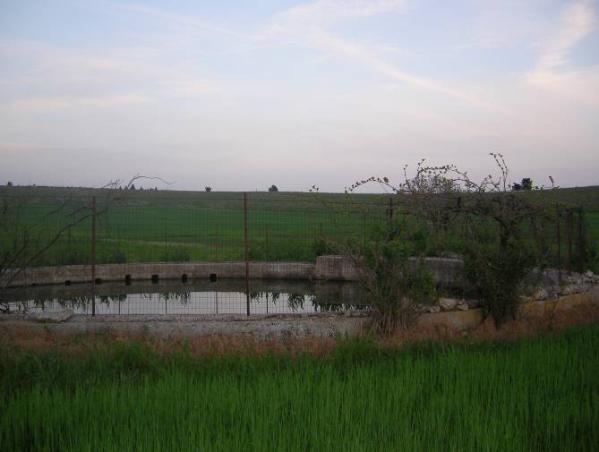
During the storms, the water in the doline reaches a relatively high level. This water flows out partly via the sinkhole partly via the porous limestone external walls. The water is absorbed in a very short time, usually a few hours. Water stagnates longer in the central area, which is also the lowest. In this central area, at the time of Carmelo Colamonico (1917), there was a tree and a pit for rainwater, while today there is an open tank used for rainwater.
 Close to the doline are the ruins of a small XX century primary school both for children and adults.
History
The doline (or "karst basin") was practically unknown among scientists and scholars until the first study published by Carmelo Colamonico in 1917. Previously it had been cited only by F. Virgilio (1900), who called it just "Gurio". C. Colamonico (1917), p. 19 F. Virgilio (1900), p. 97Etymology
Carmelo Colamonico was the first person who called it with its name. He noticed that on the maps of the Italian geographic instituteIstituto Geografico Militare
The ''Istituto Geografico Militare'' (IGM), or Military Geographic Institute, is an Italian public organization, dependent on the Italian Army general staff (''Stato Maggiore dell'Esercito''). It is the national mapping agency for Italy.
Overvie ...
of that time the area, comprising a cluster of buildings nearby, was just named ''Masseria Crocetta'', but its real name instead was ''Masseria Gurio Lamanna''. Carmelo Colamonico identified the real nome of the area (''Masseria Gurio Lamanna'') and first used the term "Gurio Lamanna" to refer to the doline. As a proof of the correctness of Carmelo Colamonico's intuition, the word ''gurio'' is used in the Murge
The Altopiano delle Murge (Italian for "Murge plateau") is a karst topographic plateau of rectangular shape in southern Italy. Most of it lies within Apulia and corresponds with the sub-region known as Murgia or Le Murge. The plateau lies mainl ...
region to denote a large and flat sinkhole
A sinkhole is a depression or hole in the ground caused by some form of collapse of the surface layer. The term is sometimes used to refer to doline, enclosed depressions that are locally also known as ''vrtače'' and shakeholes, and to openi ...
collecting a large amount of rainwater.
Origin and evolution
The origin of the karst basin Gurio Lamanna can be explained with karst processes. The water coming from the relativedrainage basin
A drainage basin is an area of land where all flowing surface water converges to a single point, such as a river mouth, or flows into another body of water, such as a lake or ocean. A basin is separated from adjacent basins by a perimeter, ...
has slowly but constantly eroded (according to the usual double action - chemical and mechanical - of rainwater, typical of karst phenomena) the area, leading to the formation of the wide flat area full of fertile soil that is visible today.
 Carmelo Colamonico hypothesized that, initially, there may have been a
 ditch
A ditch is a small to moderate divot created to channel water. A ditch can be used for drainage, to drain water from low-lying areas, alongside roadways or fields, or to channel water from a more distant source for plant irrigation. Ditches ar ...
in direction NW-SE caused by tectonic
Tectonics (; ) are the processes that control the structure and properties of the Earth's crust and its evolution through time. These include the processes of mountain building, the growth and behavior of the strong, old cores of continents ...
phenomena. Nevertheless, he noticed that today's dimensions would have never been reached if there had not been the double action of rainwater coming from such a large drainage basin
A drainage basin is an area of land where all flowing surface water converges to a single point, such as a river mouth, or flows into another body of water, such as a lake or ocean. A basin is separated from adjacent basins by a perimeter, ...
( karst).
Rainwater mainly comes from two lamas Lamas may refer to:
* the plural form of Lama, a title for a teacher of the Dharma in Tibetan Buddhism.
Places
*Lamas Province, Peru
**Lamas District
** Lamas, Peru, the capital of Lamas Province and seat of Lamas District
*Lamas (Braga), a paris ...
, one located NW and the other NE. Both of them contribute to the erosion phenomenon, although the NW lama probably contributed (and still contributes) more than the NE lama. The erosion occurred (and still occurs) mainly in the northern direction in the region between the two lamas Lamas may refer to:
* the plural form of Lama, a title for a teacher of the Dharma in Tibetan Buddhism.
Places
*Lamas Province, Peru
**Lamas District
** Lamas, Peru, the capital of Lamas Province and seat of Lamas District
*Lamas (Braga), a paris ...
.
See also
* Altamura *Gravina in Puglia
Gravina in Puglia (; nap, label= Barese, Gravéine ; la, Silvium; grc, Σιλούϊον, Siloúïon) is a town and ''comune'' of the Metropolitan City of Bari, Apulia, southern Italy.
The word ''gravina'' comes from the Latin ''grava'' or from ...
* Lama (geology)
Lama is a local toponym that denotes a wide furrow in the ground typical of the Murge landscape. Lamas convey rainwater from the Murge plateau to the endpoint of the drainage basin they belong to.
Lamas are generally confused with rivers or stream ...
* Pulicchio di Gravina
* Pulo di Altamura
Pulo di Altamura is a doline located on the Murge plateau ( Apulia, Italy). It is the largest doline in that region and it is located about north-west of the city of Altamura. It shares the local toponym ''pulo'' with other large dolines of the ...
References
Sources
* * * {{cite journal , first=Renato , last=Biasutti , title=Sulla nomenclatura relativa ai fenomeni carsici , journal=Rivista Geografica Italiana , place=Florence , volume=3 , issue=f. 1 , year=1916 , language=it , ref=Biasutti-1916 Karst Landforms of Apulia Sinkholes of Italy