|
Sinkhole
A sinkhole is a depression or hole in the ground caused by some form of collapse of the surface layer. The term is sometimes used to refer to doline, enclosed depressions that are locally also known as ''vrtače'' and shakeholes, and to openings where surface water enters into underground passages known as '' ponor'', swallow hole or swallet. A '' cenote'' is a type of sinkhole that exposes groundwater underneath. A ''sink'' or ''stream sink'' are more general terms for sites that drain surface water, possibly by infiltration into sediment or crumbled rock. Most sinkholes are caused by karst processes – the chemical dissolution of carbonate rocks, collapse or suffosion processes. Sinkholes are usually circular and vary in size from tens to hundreds of meters both in diameter and depth, and vary in form from soil-lined bowls to bedrock-edged chasms. Sinkholes may form gradually or suddenly, and are found worldwide. Formation Natural processes Sinkholes may capture ... [...More Info...] [...Related Items...] OR: [Wikipedia] [Google] [Baidu] |
Cenote
A cenote ( or ; ) is a natural pit, or sinkhole, resulting from the collapse of limestone bedrock that exposes groundwater. The regional term is specifically associated with the Yucatán Peninsula of Mexico, where cenotes were commonly used for water supplies by the ancient Maya, and occasionally for sacrificial offerings. The term derives from a word used by the lowland Yucatec Maya——to refer to any location with accessible groundwater. Similar rock-sided sinkholes like cenotes are common geological forms in low-altitude regions, particularly on islands, coastlines, and platforms with young post-Paleozoic limestone with little soil development. The term ''cenote'' has also been used to describe similar karst features in other countries such as Cuba and Australia. Definition and description Cenotes are surface connections to subterranean water bodies. While the best-known cenotes are large open-water pools measuring tens of meters in diameter, such as those at Chichen ... [...More Info...] [...Related Items...] OR: [Wikipedia] [Google] [Baidu] |
Cedar Sink
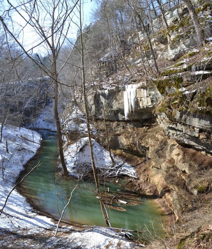
Cedar Sink is a vertical-walled large depression, or sinkhole, in the ground, that is located in Edmonson County, Kentucky and contained within and managed by Mammoth Cave National Park. The sinkhole measures from the top sandstone plateau to the bottom of the sink and was caused by collapse of the surface soil. The landscape is karst topography, which means the region is influenced by the dissolution of soluble rocks. Sinkholes, caves, and dolines typically characterize these underground drainage systems. Cedar Sink has a bottom area of about and has more fertile soil compared to the ridgetops. Geomorphology Rock age The rocks of Cedar Sink and the surrounding area are from the Mississippian (also known as Lower Carboniferous or Early Carboniferous) subperiod that occurred 358.9 to 323.2 million years ago. Cedar Sink formation The Big Clifty Sandstone caprock has been breached exposing the limestone Girkin Formation resulting in a relief between approximately below the main ... [...More Info...] [...Related Items...] OR: [Wikipedia] [Google] [Baidu] |
Karst Topography
Karst is a topography formed from the dissolution of soluble rocks such as limestone, dolomite, and gypsum. It is characterized by underground drainage systems with sinkholes and caves. It has also been documented for more weathering-resistant rocks, such as quartzite, given the right conditions. Subterranean drainage may limit surface water, with few to no rivers or lakes. However, in regions where the dissolved bedrock is covered (perhaps by debris) or confined by one or more superimposed non-soluble rock strata, distinctive karst features may occur only at subsurface levels and can be totally missing above ground. The study of ''paleokarst'' (buried karst in the stratigraphic column) is important in petroleum geology because as much as 50% of the world's hydrocarbon reserves are hosted in carbonate rock, and much of this is found in porous karst systems. Etymology The English word ''karst'' was borrowed from German in the late 19th century, which entered German much ... [...More Info...] [...Related Items...] OR: [Wikipedia] [Google] [Baidu] |
Suffosion
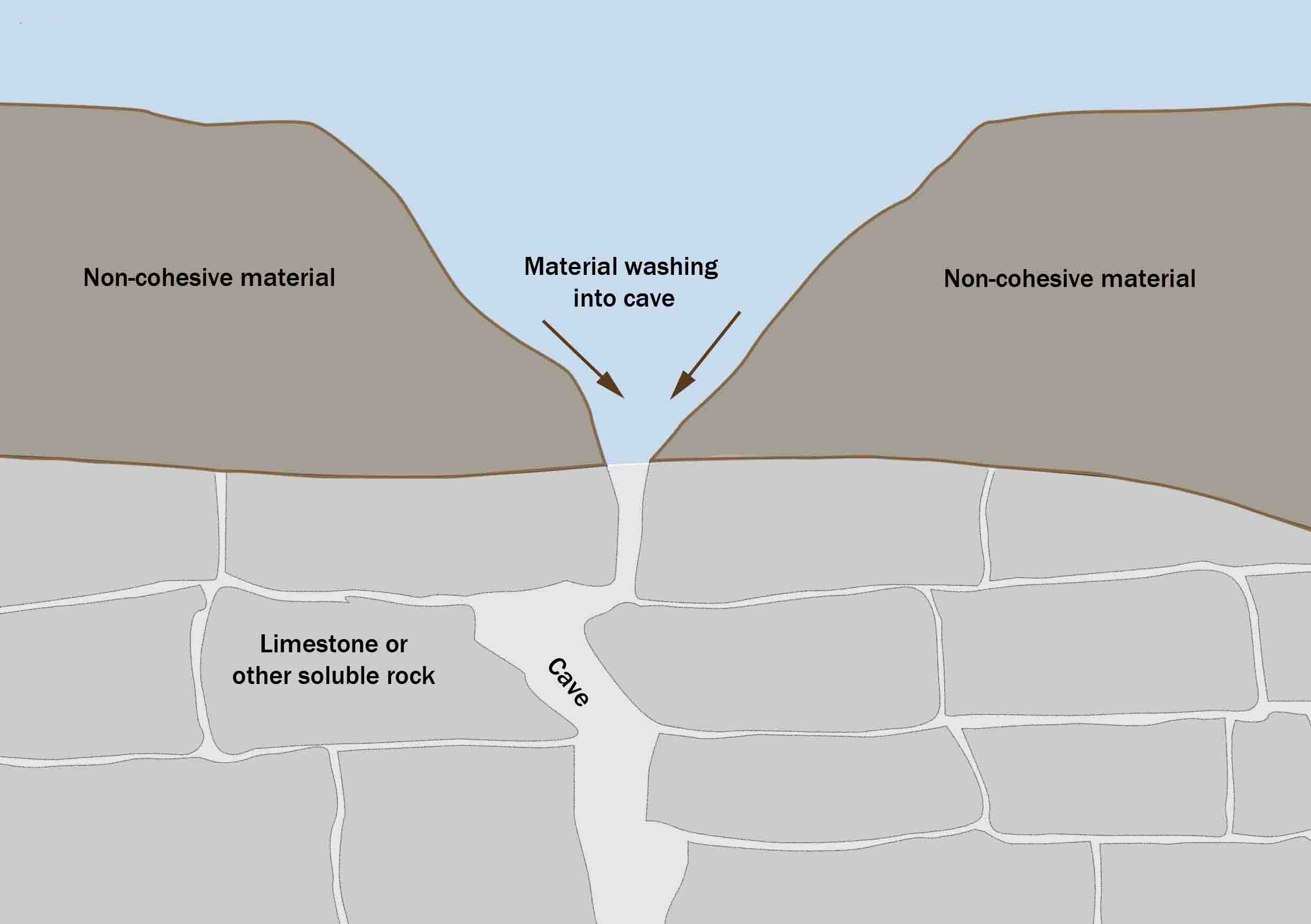
Suffosion is one of the two geological processes by which subsidence sinkholes or dolines are formed, the other being due to collapse of an underlying cave or void, with most sinkholes formed by the suffosion process. Suffosion sinkholes are normally associated with karst topography although they may form in other types of rock including chalk, gypsum and basalt. In the karst of the UK's Yorkshire Dales, numerous surface depressions known locally as "shakeholes" are the result of glacial till washing into fissures in the underlying limestone. Process Suffosion occurs when loose soil, loess, or other non-cohesive material lies on top of a limestone substratum containing fissures and joints. Rain and surface water gradually wash this material through these fissures and into caves beneath. Over time, this creates a depression on the landscape of varying depth. Suffosion versus suffusion Suffosion is a destructive process that creates instability leading to collapse of the soil stru ... [...More Info...] [...Related Items...] OR: [Wikipedia] [Google] [Baidu] |
Subsidence
Subsidence is a general term for downward vertical movement of the Earth's surface, which can be caused by both natural processes and human activities. Subsidence involves little or no horizontal movement, which distinguishes it from slope movement. Processes that lead to subsidence include dissolution of underlying carbonate rock by groundwater; gradual compaction of sediments; withdrawal of fluid lava from beneath a solidified crust of rock; mining; pumping of subsurface fluids, such as groundwater or petroleum; or warping of the Earth's crust by tectonic forces. Subsidence resulting from tectonic deformation of the crust is known as tectonic subsidence and can create accommodation for sediments to accumulate and eventually lithify into sedimentary rock. Ground subsidence is of global concern to geologists, geotechnical engineers, surveyors, engineers, urban planners, landowners, and the public in general.National Research Council, 1991. ''Mitigating losses from lan ... [...More Info...] [...Related Items...] OR: [Wikipedia] [Google] [Baidu] |
Carbonate Rock
Carbonate rocks are a class of sedimentary rocks composed primarily of carbonate minerals. The two major types are limestone, which is composed of calcite or aragonite (different crystal forms of CaCO3), and dolomite rock (also known as dolostone), which is composed of mineral dolomite (CaMg(CO3)2). Calcite can be either dissolved by groundwater or precipitated by groundwater, depending on several factors including the water temperature, pH, and dissolved ion concentrations. Calcite exhibits an unusual characteristic called retrograde solubility in which it becomes less soluble in water as the temperature increases. When conditions are right for precipitation, calcite forms mineral coatings that cement the existing rock grains together or it can fill fractures. Karst topography and caves develop in carbonate rocks because of their solubility in dilute acidic groundwater. Cooling groundwater or mixing of different groundwaters will also create conditions suitable for cave ... [...More Info...] [...Related Items...] OR: [Wikipedia] [Google] [Baidu] |
Ponor
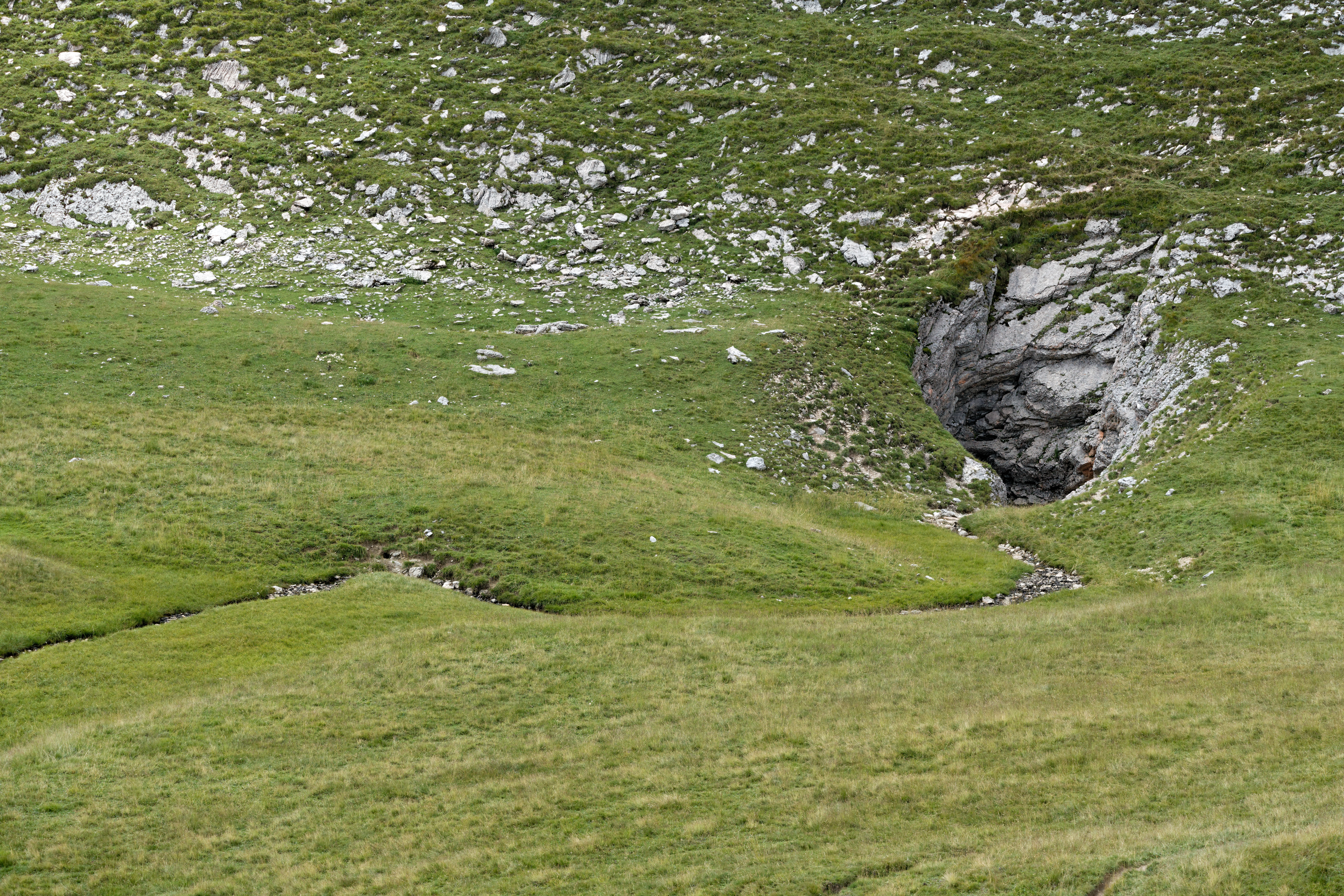
A ponor is a natural opening where surface water enters into underground passages; they may be found in karst landscapes where the geology and the geomorphology is typically dominated by porous limestone rock. Ponors can drain stream or lake water continuously or can at times work as springs, similar to estavelles. Morphologically, ponors come in forms of large pits and caves, large fissures and caverns, networks of smaller cracks, and sedimentary, alluvial drains. Etymology The name for the karst formation ponor comes from Croatian and Slovene. It derives from the proto-Slavic word ''nora'', meaning ''pit'', ''hole'', ''abyss''; the English word ''narrow'' probably has the same origin. Several places in southeast Europe (Bulgaria, Croatia, Czech Republic, Hungary, Romania, Montenegro, Slovenia) bear the name ''Ponor'' due to associated karst openings. Description Whereas a sinkhole (doline) is a depression of surface topography with a pit or cavity directly underneath, a pon ... [...More Info...] [...Related Items...] OR: [Wikipedia] [Google] [Baidu] |
07 Imotski Crveno Jezero (1)
7 (seven) is the natural number following 6 and preceding 8. It is the only prime number preceding a cube. As an early prime number in the series of positive integers, the number seven has greatly symbolic associations in religion, mythology, superstition and philosophy. The seven Classical planets resulted in seven being the number of days in a week. It is often considered lucky in Western culture and is often seen as highly symbolic. Unlike Western culture, in Vietnamese culture, the number seven is sometimes considered unlucky. It is the first natural number whose pronunciation contains more than one syllable. Evolution of the Arabic digit In the beginning, Indians wrote 7 more or less in one stroke as a curve that looks like an uppercase vertically inverted. The western Ghubar Arabs' main contribution was to make the longer line diagonal rather than straight, though they showed some tendencies to making the digit more rectilinear. The eastern Arabs developed the digit f ... [...More Info...] [...Related Items...] OR: [Wikipedia] [Google] [Baidu] |
Kentucky
Kentucky ( , ), officially the Commonwealth of Kentucky, is a state in the Southeastern region of the United States and one of the states of the Upper South. It borders Illinois, Indiana, and Ohio to the north; West Virginia and Virginia to the east; Tennessee to the south; and Missouri to the west. Its northern border is defined by the Ohio River. Its capital is Frankfort, Kentucky, Frankfort, and its two largest cities are Louisville, Kentucky, Louisville and Lexington, Kentucky, Lexington. Its population was approximately 4.5 million in 2020. Kentucky was admitted into the Union as the 15th state on June 1, 1792, Kentucky County, Virginia, splitting from Virginia in the process. It is known as the "Bluegrass State", a nickname based on Kentucky bluegrass, a species of green grass found in many of its pastures, which has supported the thoroughbred horse industry in the center of the state. Historically, it was known for excellent farming conditions for this reason and ... [...More Info...] [...Related Items...] OR: [Wikipedia] [Google] [Baidu] |
Underground Stream
A subterranean river is a river that runs wholly or partly beneath the ground surface – one where the riverbed does not represent the surface of the Earth. It is distinct from an aquifer, which may flow like a river but is contained within a permeable layer of rock or other unconsolidated materials. A river flowing below ground level in an open gorge is not classed as subterranean. Subterranean rivers may be entirely natural, flowing through cave systems. In karst topography, rivers may disappear through sinkholes, continuing underground. In some cases, they may emerge into daylight further downstream. The longest subterranean river in the world is the Sistema Sac Actun cave system in Mexico. Subterranean rivers can also be the result of covering over a river or diverting its flow into culverts, usually as part of urban development.Richard J. Heggen: Underground Rivers from the River Styx to the Rio San Buenaventura with Occasional Diversions'', University of New Mexico. Rever ... [...More Info...] [...Related Items...] OR: [Wikipedia] [Google] [Baidu] |
Quartzite
Quartzite is a hard, non- foliated metamorphic rock which was originally pure quartz sandstone.Essentials of Geology, 3rd Edition, Stephen Marshak, p 182 Sandstone is converted into quartzite through heating and pressure usually related to tectonic compression within orogenic belts. Pure quartzite is usually white to grey, though quartzites often occur in various shades of pink and red due to varying amounts of hematite. Other colors, such as yellow, green, blue and orange, are due to other minerals. The term ''quartzite'' is also sometimes used for very hard but unmetamorphosed sandstones that are composed of quartz grains thoroughly cemented with additional quartz. Such sedimentary rock has come to be described as orthoquartzite to distinguish it from metamorphic quartzite, which is sometimes called metaquartzite to emphasize its metamorphic origins. Quartzite is very resistant to chemical weathering and often forms ridges and resistant hilltops. The nearly pure silica co ... [...More Info...] [...Related Items...] OR: [Wikipedia] [Google] [Baidu] |
.jpg)


.jpg)


