|
Lama (geology)
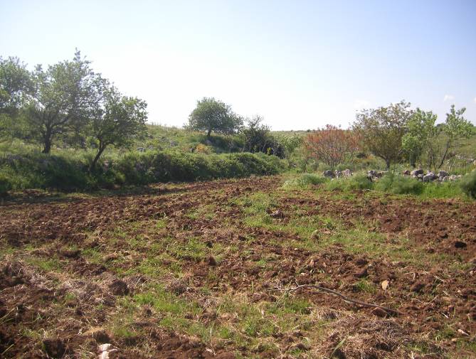
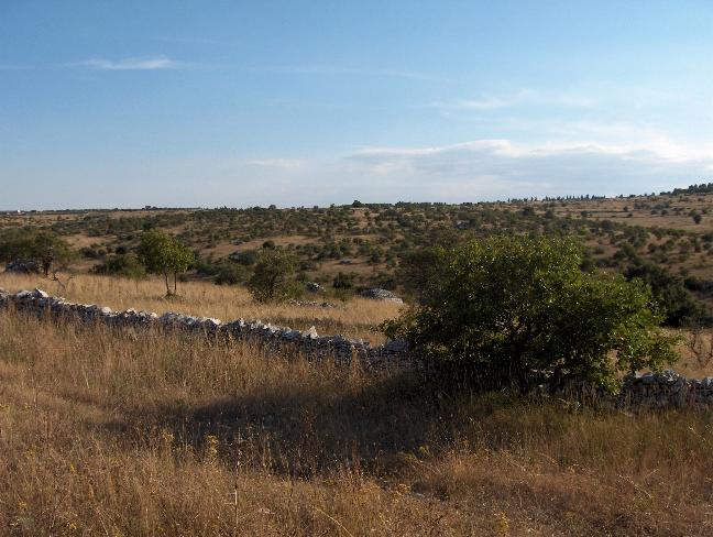
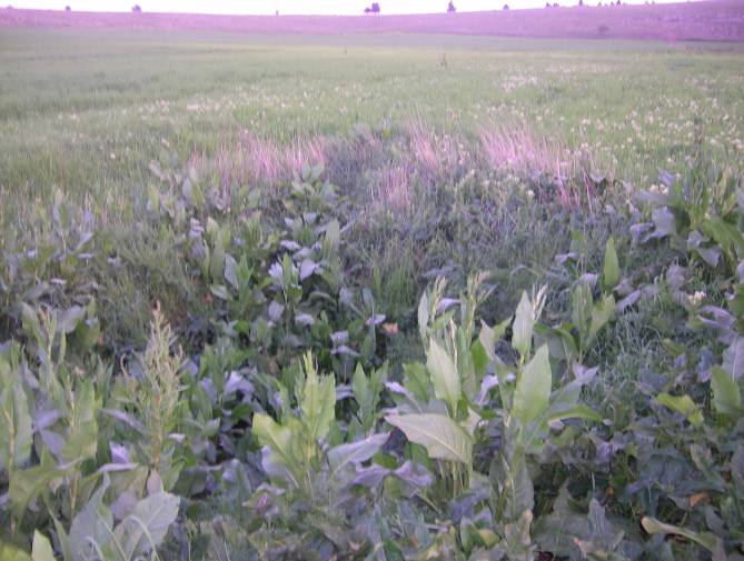
Lama is a local toponym that denotes a wide furrow in the ground typical of the Murge landscape. Lamas convey rainwater from the Murge plateau to the endpoint of the drainage basin they belong to. Lamas are generally confused with rivers or streams. There is a big difference between lamas and streams, since lamas collect only rainwater of their drainage basin, while they are completely dry when there is no rain. Moreover, in lamas water mostly flows underground and just a small amount of the rainwater flows on its surface. As for lamas, surface runoff is greatest in the extreme and uncommon situations of heavy rain. Lamas usually contain fertile soil, that deposited over the millennia due to the erosion and they are usually cultivated. Since they contain fertile soil, they are distinguishable from the nearby typical area of the Murge plateau, that is almost everywhere stony, arid and hard to grow. Lamas also occur in proximity of such notable dolines as Pulo di Altamura, Gurio L ... [...More Info...] [...Related Items...] OR: [Wikipedia] [Google] [Baidu] |
Lama NW
Lama (; "chief") is a title for a teacher of the Dharma in Tibetan Buddhism. The name is similar to the Sanskrit term ''guru'', meaning "heavy one", endowed with qualities the student will eventually embody. The Tibetan word "lama" means "highest principle", and less literally "highest mother" or "highest parent" to show close relationship between teacher and student."lama" from Historically, the term was used for venerated spiritual masters or heads of . Today the title can be used as an [...More Info...] [...Related Items...] OR: [Wikipedia] [Google] [Baidu] |
Murge
The Altopiano delle Murge (Italian for "Murge plateau") is a karst topographic plateau of rectangular shape in southern Italy. Most of it lies within Apulia and corresponds with the sub-region known as Murgia or Le Murge. The plateau lies mainly in the Metropolitan City of Bari and the province of Barletta-Andria-Trani, but extends into the provinces of Brindisi and Taranto to the south, and into Matera in Basilicata to the west. The name is believed to originate from the Latin ''murex'', meaning "sharp stone". Geography and geology The Murge plateau covers a surface of some 4,000 km², bordered by the Ofanto river and the Tavoliere delle Puglie to the north, the Adriatic Sea to the northeast, and by the Messapic depression, which separates it from the Salento peninsula, to the south. It is usually divided into Alta Murgia (High Murgia), the highest area, with poorer vegetation, and Bassa Murgia (Lower Murgia), with more fertile land, extensively planted with olive-tre ... [...More Info...] [...Related Items...] OR: [Wikipedia] [Google] [Baidu] |
Drainage Basin
A drainage basin is an area of land where all flowing surface water converges to a single point, such as a river mouth, or flows into another body of water, such as a lake or ocean. A basin is separated from adjacent basins by a perimeter, the '' drainage divide'', made up of a succession of elevated features, such as ridges and hills. A basin may consist of smaller basins that merge at river confluences, forming a hierarchical pattern. Other terms for a drainage basin are catchment area, catchment basin, drainage area, river basin, water basin, and impluvium. In North America, they are commonly called a watershed, though in other English-speaking places, "watershed" is used only in its original sense, that of a drainage divide. In a closed drainage basin, or endorheic basin, the water converges to a single point inside the basin, known as a sink, which may be a permanent lake, a dry lake, or a point where surface water is lost underground. Drainage basins are simi ... [...More Info...] [...Related Items...] OR: [Wikipedia] [Google] [Baidu] |
Surface Runoff
Surface runoff (also known as overland flow) is the flow of water occurring on the ground surface when excess rainwater, stormwater, meltwater, or other sources, can no longer sufficiently rapidly infiltrate in the soil. This can occur when the soil is saturated by water to its full capacity, and the rain arrives more quickly than the soil can absorb it. Surface runoff often occurs because impervious areas (such as roofs and pavement) do not allow water to soak into the ground. Furthermore, runoff can occur either through natural or man-made processes. Surface runoff is a major component of the water cycle. It is the primary agent of soil erosion by water. The land area producing runoff that drains to a common point is called a drainage basin. Runoff that occurs on the ground surface before reaching a channel can be a nonpoint source of pollution, as it can carry man-made contaminants or natural forms of pollution (such as rotting leaves). Man-made contaminants in run ... [...More Info...] [...Related Items...] OR: [Wikipedia] [Google] [Baidu] |
Pulo Di Altamura
Pulo di Altamura is a doline located on the Murge plateau ( Apulia, Italy). It is the largest doline in that region and it is located about north-west of the city of Altamura. It shares the local toponym ''pulo'' with other large dolines of the region, i.e. ''Pulicchio di Gravina'', ''Pulo di Molfetta'' and ''Pulicchio di Toritto''. Dimensions The perimeter, measured on the edge of the doline, is around . The larger diameter is abit bigger than and it is never lower than . The depth is around . Etymology The etymology of toponym ''pulo'' is currently unknown. It is used only in the Murge plateau to denote a doline, while it is unused in other regions of Apulia. The term is also used for the nearby dolines Pulo di Molfetta, Pulicchio di Gravina and Pulicchio di Toritto (''pulicchio'' means small ''pulo''), and it is attested as early as in the 17th century, since Domenico Santoro in 1688 wrote "luogo detto dalli Cittadini lo Pulo" (place called by Altamura people 'Pulo') ... [...More Info...] [...Related Items...] OR: [Wikipedia] [Google] [Baidu] |
Gurio Lamanna
Gurio Lamanna (also incorrectly called Gurlamanna) is a doline shaped like a coat of arms located in the Murge plateau and falling into Gravina in Puglia's territory, on the border with Altamura, Apulia, southern Italy. It is "one of the largest karst landforms of the Murge plateau" C. Colamonico (1917), p. 21 and it is located very close to other two dolines, namely Pulicchio di Gravina and Tre Paduli. Depending on the type of geomorphologic classification employed and the author who suggested it, the karst landform can be defined either a doline or a "karst basin" ( it, bacino carsico). It is traditionally called "karst basin", following the suggestion of Carmelo Colamonico, who first studied the doline and saw in its large size and shallow depth a good reason to distinguish it from a normal doline. C. Colamonico (1917), p. 22 The definition of "karst basin", used by Carmelo Colamonico, has been introduced by Renato Biasutti. Carmelo Colamonico stated that Gurio Lamanna i ... [...More Info...] [...Related Items...] OR: [Wikipedia] [Google] [Baidu] |
Karst
Karst is a topography formed from the dissolution of soluble rocks such as limestone, Dolomite (rock), dolomite, and gypsum. It is characterized by underground drainage systems with sinkholes and caves. It has also been documented for more weathering-resistant rocks, such as quartzite, given the right conditions. Subterranean drainage may limit surface water, with few to no rivers or lakes. However, in regions where the dissolved bedrock is covered (perhaps by debris) or confined by one or more superimposed non-soluble rock strata, distinctive karst features may occur only at subsurface levels and can be totally missing above ground. The study of ''paleokarst'' (buried karst in the stratigraphic column) is important in petroleum geology because as much as 50% of the world's hydrocarbon reserves are hosted in carbonate rock, and much of this is found in porous karst systems. Etymology The English word ''karst'' was borrowed from German language, German in the late 19th century, ... [...More Info...] [...Related Items...] OR: [Wikipedia] [Google] [Baidu] |
Neolithic Age
The Neolithic period, or New Stone Age, is an Old World archaeological period and the final division of the Stone Age. It saw the Neolithic Revolution, a wide-ranging set of developments that appear to have arisen independently in several parts of the world. This "Neolithic package" included the introduction of farming, domestication of animals, and change from a hunter-gatherer lifestyle to one of settlement. It began about 12,000 years ago when farming appeared in the Epipalaeolithic Near East, and later in other parts of the world. The Neolithic lasted in the Near East until the transitional period of the Chalcolithic (Copper Age) from about 6,500 years ago (4500 BC), marked by the development of metallurgy, leading up to the Bronze Age and Iron Age. In other places the Neolithic followed the Mesolithic (Middle Stone Age) and then lasted until later. In Ancient Egypt, the Neolithic lasted until the Protodynastic period, 3150 BC.Karin Sowada and Peter Grave. Egy ... [...More Info...] [...Related Items...] OR: [Wikipedia] [Google] [Baidu] |
Apulia
it, Pugliese , population_note = , population_blank1_title = , population_blank1 = , demographics_type1 = , demographics1_footnotes = , demographics1_title1 = , demographics1_info1 = , demographics1_title2 = , demographics1_info2 = , demographics1_title3 = , demographics1_info3 = , timezone1 = CET , utc_offset1 = +01:00 , timezone1_DST = CEST , utc_offset1_DST = +02:00 , postal_code_type = , postal_code = , area_code_type = ISO 3166 code , area_code = IT-75 , blank_name_sec1 = GDP (nominal) , blank_info_sec1 = €76.6 billion (2018) , blank1_name_sec1 = GDP per capita , blank1_info_sec1 = €19,000 (2018) , blank2_name_sec1 = HDI (2018) , blank2_info_sec1 = 0.845 · 18th of 21 , blank_name_sec2 = NUTS Region , blank_info_sec2 ... [...More Info...] [...Related Items...] OR: [Wikipedia] [Google] [Baidu] |
Water Table
The water table is the upper surface of the zone of saturation. The zone of saturation is where the pores and fractures of the ground are saturated with water. It can also be simply explained as the depth below which the ground is saturated. The water table is the surface where the water pressure head is equal to the atmospheric pressure (where gauge pressure = 0). It may be visualized as the "surface" of the subsurface materials that are saturated with groundwater in a given vicinity. The groundwater may be from precipitation or from groundwater flowing into the aquifer. In areas with sufficient precipitation, water infiltrates through pore spaces in the soil, passing through the unsaturated zone. At increasing depths, water fills in more of the pore spaces in the soils, until a zone of saturation is reached. Below the water table, in the phreatic zone (zone of saturation), layers of permeable rock that yield groundwater are called aquifers. In less permeable soils, such as ... [...More Info...] [...Related Items...] OR: [Wikipedia] [Google] [Baidu] |
Karst
Karst is a topography formed from the dissolution of soluble rocks such as limestone, Dolomite (rock), dolomite, and gypsum. It is characterized by underground drainage systems with sinkholes and caves. It has also been documented for more weathering-resistant rocks, such as quartzite, given the right conditions. Subterranean drainage may limit surface water, with few to no rivers or lakes. However, in regions where the dissolved bedrock is covered (perhaps by debris) or confined by one or more superimposed non-soluble rock strata, distinctive karst features may occur only at subsurface levels and can be totally missing above ground. The study of ''paleokarst'' (buried karst in the stratigraphic column) is important in petroleum geology because as much as 50% of the world's hydrocarbon reserves are hosted in carbonate rock, and much of this is found in porous karst systems. Etymology The English word ''karst'' was borrowed from German language, German in the late 19th century, ... [...More Info...] [...Related Items...] OR: [Wikipedia] [Google] [Baidu] |


.jpg)

.jpg)