|
Zündorf
Zündorf (german: Köln-Zündorf) is a suburb of Cologne, Germany and part of the district of Porz. Zündorf lies on the right bank of the river Rhine, between Langel and Porz. Zündorf has 12.229 inhabitants (as of 31 December 2008) and covers an area of 8,12 km². The former village grew from a small trading post with staple rights on the Rhine isle of Groov, which nowadays is a peninsula and popular as a local recreation area with numerous outdoor restaurants as well as a rowing and pedal boat rental station. Public transport Zündorf is served by Cologne Stadtbahn line 7 and several Cologne bus lines. A ferryline links Zündorf to Weiß, a suburb of Cologne on the opposite Rhine bank. Groov In the past, a river branch had been separated from the Rhine by the Groov island, also called ''Mittelwerth''. Prone to silting, as a consequence of the 1831 staple right abolishment, the island was connected downstream to the mainland by a dam in 1849 and broadened in 1862 b ... [...More Info...] [...Related Items...] OR: [Wikipedia] [Google] [Baidu] |
Zündorf Synagogue
Zündorf Synagogue (German: ''Synagoge Zündorf'') was a synagogue and cemetery in Cologne, Germany. Zündorf Zündorf (german: Köln-Zündorf) is a suburb of Cologne, Germany and part of the district of Porz. Zündorf lies on the right bank of the river Rhine, between Langel and Porz. Zündorf has 12.229 inhabitants (as of 31 December 2008) and covers an ... was an important trading center, of Jewish farmers, butchers, moneylenders, small artisans or goods dealers from the early 18th century. History The Jewish history of Zündorf dates back to before 1700. The first historical evidence is the burial of the Jew Ishar on July 2, 1708 at the Deutz cemetery, which was also the last resting place for the Jews of Zündorf until the creation of a separate graveyard in 1923. The Jewish cemetery of Zündorf still has eight graves with six gravestones. Architecture The two-storey building was made of brick and had a gable roof. It was 6.7 metres wide and 8.9 metres deep. The floor area w ... [...More Info...] [...Related Items...] OR: [Wikipedia] [Google] [Baidu] |
Cologne Stadtbahn
The Cologne Stadtbahn is a light rail system in the German city of Cologne, including several surrounding cities of the Cologne Bonn Region (Bergisch Gladbach, Bonn, Bornheim, Brühl, Frechen, Hürth, Leverkusen-Schlebusch, Wesseling). The term ''Stadtbahn'' denotes a system that encompasses elements of trams as well as an underground railway network (''U-Bahn'') and interurban rail, even including three lines that are licensed as heavy rail and used by freight trains as well as Stadtbahn vehicles. Two of these lines connect the Cologne Stadtbahn to the Bonn Stadtbahn. These lines (16 and 18) are jointly operated by both cities' transport authorities, resulting in both systems and the lines connecting them sometimes collectively referred to as ''Stadtbahn Rhein-Sieg''. The Cologne Stadtbahn is operated by the Kölner Verkehrsbetriebe (KVB) and the Bonn Stadtbahn is operated by the Stadtwerke Bonn (SWB – City of Bonn Utilities Division). The KVB and SWB are members of the V ... [...More Info...] [...Related Items...] OR: [Wikipedia] [Google] [Baidu] |
Boroughs And Quarters Of Cologne
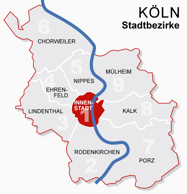
Since the last administrative reform in 1975, the City of Cologne is made up of nine Stadtbezirke and 86 Stadtteile. '' Stadtbezirk'' literally translates as city district, which are further subdivided into ''Stadtteile'' (city parts). The Stadtteile of Cologne's old and new town (''Alt-'' and ''Neustadt'') further consist of quarters, known as "''Veedel''" in both Kölsch and most often, the Rhinelandic regiolect, as well. City districts are differentiated of being ''links-'' or ''rechtsrheinisch'' – ''left'' or ''right of the Rhine'', with the old town being left of the Rhine, as are 230,25 km2 (56.8 percent of 405,14 km2 within city limits), while 174,87 km2 (43.2 percent) lie right of the Rhine. In regard to population, Cologne is the largest city in the state of North Rhine-Westphalia and the fourth largest city in Germany. Districts Growth of urban area Since the city's foundation in 38 BC, Cologne grew through numerous extensions and incorporat ... [...More Info...] [...Related Items...] OR: [Wikipedia] [Google] [Baidu] |
Porz Stadtteil Zündorf
Porz () is a borough or ''Stadtbezirk'' of Cologne, Germany. It is situated on the east side of the Rhine in the south-east of the city. Porz is the largest borough of Cologne by area at 78.92 km2 and has 113,500 inhabitants. Porz borders with the Cologne boroughs of Kalk and Innenstadt to the North, Rheinisch-Bergischer Kreis and Rhein-Sieg-Kreis to the East and South, and the Rhine to the West. On the other riverbank lies the Cologne borough of Rodenkirchen. History In 1951 the former independent town of Porz was awarded the town privileges (). In the course of the local government reform in the 1970s in North Rhine-Westphalia, Porz was incorporated with Cologne. Subdivisions Porz consists of 16 Stadtteile (city parts): Economy Organisations based in Porz include: The German Aerospace Center, TÜV Rheinland, The European Astronaut Centre of the European Space Agency and the Cologne-Bonn airport. Engine manufacturer Deutz AG has its headquarter and a R&D facilit ... [...More Info...] [...Related Items...] OR: [Wikipedia] [Google] [Baidu] |
Cologne
Cologne ( ; german: Köln ; ksh, Kölle ) is the largest city of the German western States of Germany, state of North Rhine-Westphalia (NRW) and the List of cities in Germany by population, fourth-most populous city of Germany with 1.1 million inhabitants in the city proper and 3.6 million people in the Cologne Bonn Region, urban region. Centered on the left bank of the Rhine, left (west) bank of the Rhine, Cologne is about southeast of NRW's state capital Düsseldorf and northwest of Bonn, the former capital of West Germany. The city's medieval Catholic Cologne Cathedral (), the third-tallest church and tallest cathedral in the world, constructed to house the Shrine of the Three Kings, is a globally recognized landmark and one of the most visited sights and pilgrimage destinations in Europe. The cityscape is further shaped by the Twelve Romanesque churches of Cologne, and Cologne is famous for Eau de Cologne, that has been produced in the city since 1709, and "col ... [...More Info...] [...Related Items...] OR: [Wikipedia] [Google] [Baidu] |
Porz
Porz () is a borough or '' Stadtbezirk'' of Cologne, Germany. It is situated on the east side of the Rhine in the south-east of the city. Porz is the largest borough of Cologne by area at 78.92 km2 and has 113,500 inhabitants. Porz borders with the Cologne boroughs of Kalk and Innenstadt to the North, Rheinisch-Bergischer Kreis and Rhein-Sieg-Kreis to the East and South, and the Rhine to the West. On the other riverbank lies the Cologne borough of Rodenkirchen. History In 1951 the former independent town of Porz was awarded the town privileges (). In the course of the local government reform in the 1970s in North Rhine-Westphalia, Porz was incorporated with Cologne. Subdivisions Porz consists of 16 Stadtteile (city parts): Economy Organisations based in Porz include: The German Aerospace Center, TÜV Rheinland, The European Astronaut Centre of the European Space Agency and the Cologne-Bonn airport. Engine manufacturer Deutz AG has its headquarter and a R&D facil ... [...More Info...] [...Related Items...] OR: [Wikipedia] [Google] [Baidu] |
Germany
Germany,, officially the Federal Republic of Germany, is a country in Central Europe. It is the second most populous country in Europe after Russia, and the most populous member state of the European Union. Germany is situated between the Baltic and North seas to the north, and the Alps to the south; it covers an area of , with a population of almost 84 million within its 16 constituent states. Germany borders Denmark to the north, Poland and the Czech Republic to the east, Austria and Switzerland to the south, and France, Luxembourg, Belgium, and the Netherlands to the west. The nation's capital and most populous city is Berlin and its financial centre is Frankfurt; the largest urban area is the Ruhr. Various Germanic tribes have inhabited the northern parts of modern Germany since classical antiquity. A region named Germania was documented before AD 100. In 962, the Kingdom of Germany formed the bulk of the Holy Roman Empire. During the 16th ce ... [...More Info...] [...Related Items...] OR: [Wikipedia] [Google] [Baidu] |
Rhine
), Surselva, Graubünden, Switzerland , source1_coordinates= , source1_elevation = , source2 = Rein Posteriur/Hinterrhein , source2_location = Paradies Glacier, Graubünden, Switzerland , source2_coordinates= , source2_elevation = , source_confluence = Reichenau , source_confluence_location = Tamins, Graubünden, Switzerland , source_confluence_coordinates= , source_confluence_elevation = , mouth = North Sea , mouth_location = Netherlands , mouth_coordinates = , mouth_elevation = , progression = , river_system = , basin_size = , tributaries_left = , tributaries_right = , custom_label = , custom_data = , extra = The Rhine ; french: Rhin ; nl, Rijn ; wa, Rén ; li, Rien; rm, label= Sursilvan, Rein, rm, label= Sutsilvan and Surmiran, Ragn, rm, label=Rumantsch Grischun, Vallader and Puter, Rain; it, Reno ; gsw, Rhi(n), inclu ... [...More Info...] [...Related Items...] OR: [Wikipedia] [Google] [Baidu] |
Oxygen
Oxygen is the chemical element with the symbol O and atomic number 8. It is a member of the chalcogen group in the periodic table, a highly reactive nonmetal, and an oxidizing agent that readily forms oxides with most elements as well as with other compounds. Oxygen is Earth's most abundant element, and after hydrogen and helium, it is the third-most abundant element in the universe. At standard temperature and pressure, two atoms of the element bind to form dioxygen, a colorless and odorless diatomic gas with the formula . Diatomic oxygen gas currently constitutes 20.95% of the Earth's atmosphere, though this has changed considerably over long periods of time. Oxygen makes up almost half of the Earth's crust in the form of oxides.Atkins, P.; Jones, L.; Laverman, L. (2016).''Chemical Principles'', 7th edition. Freeman. Many major classes of organic molecules in living organisms contain oxygen atoms, such as proteins, nucleic acids, carbohydrates, and fats, as ... [...More Info...] [...Related Items...] OR: [Wikipedia] [Google] [Baidu] |
Flood Protection
Flood control methods are used to reduce or prevent the detrimental effects of flood waters."Flood Control", MSN Encarta, 2008 (see below: Further reading). Flood relief methods are used to reduce the effects of flood waters or high water levels. Flooding can be caused by a mix of both natural processes, such as extreme weather upstream, and human changes to waterbodies and runoff. Though building hard infrastructure to prevent flooding, such as flood walls, can be effective at managing flooding, increased best practice within landscape engineering is to rely more on soft infrastructure and natural systems, such as marshes and flood plains, for handling the increase in water. For flooding on coasts, coastal management practices have to not only handle changes water flow, but also natural processes like tides. Flood control and relief is a particularly important part of climate change adaptation and climate resilience, both sea level rise and changes in the weather (climate cha ... [...More Info...] [...Related Items...] OR: [Wikipedia] [Google] [Baidu] |
Rhine River
), Surselva, Graubünden, Switzerland , source1_coordinates= , source1_elevation = , source2 = Rein Posteriur/Hinterrhein , source2_location = Paradies Glacier, Graubünden, Switzerland , source2_coordinates= , source2_elevation = , source_confluence = Reichenau , source_confluence_location = Tamins, Graubünden, Switzerland , source_confluence_coordinates= , source_confluence_elevation = , mouth = North Sea , mouth_location = Netherlands , mouth_coordinates = , mouth_elevation = , progression = , river_system = , basin_size = , tributaries_left = , tributaries_right = , custom_label = , custom_data = , extra = The Rhine ; french: Rhin ; nl, Rijn ; wa, Rén ; li, Rien; rm, label= Sursilvan, Rein, rm, label= Sutsilvan and Surmiran, Ragn, rm, label=Rumantsch Grischun, Vallader and Puter, Rain; it, Reno ; gsw, Rhi(n), including i ... [...More Info...] [...Related Items...] OR: [Wikipedia] [Google] [Baidu] |


