|
Yabghus Of Tokharistan
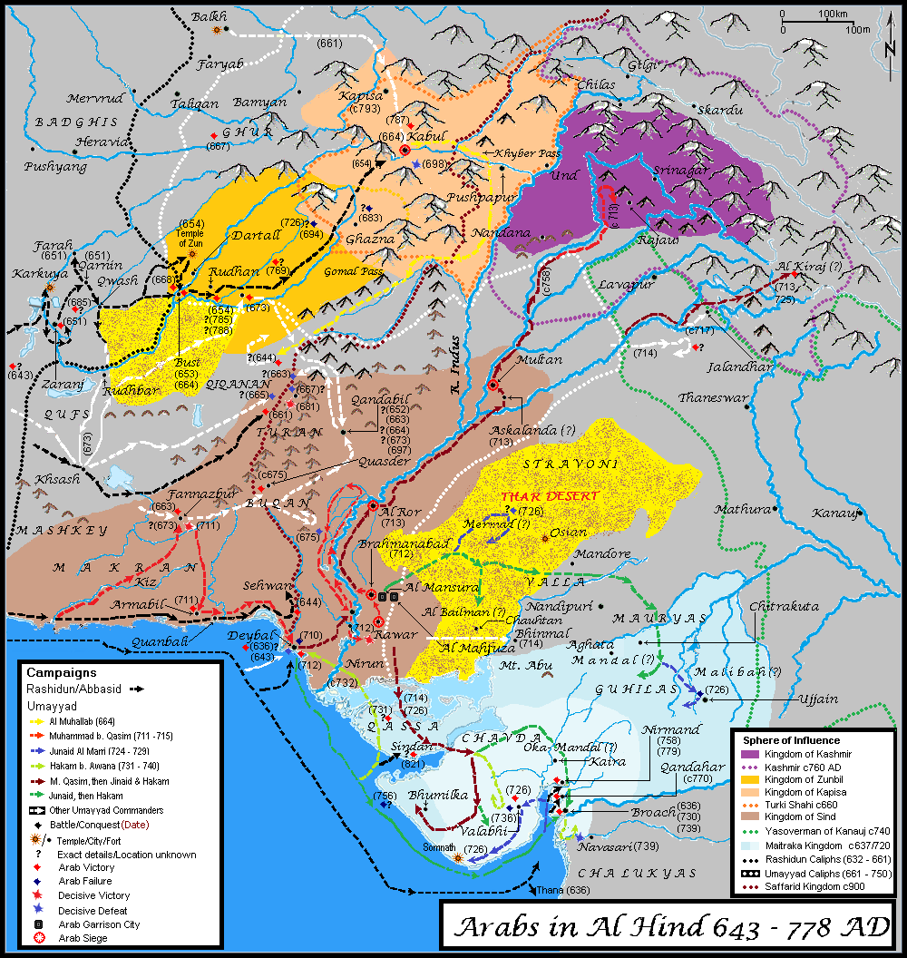
The Tokhara Yabghus or Yabghus of Tokharistan () were a dynasty of Western Turk– Hephtalite sub-kings with the title "Yabghus", who ruled from 625 CE in the area of Tokharistan north and south of the Amu Darya, Oxus River, with some smaller remnants surviving in the area of Badakhshan until 758 CE. Their legacy extended to the southeast where it came into contact with the Turk Shahis and the Zunbils until the 9th century CE. Territorial expansion The Turks initially occupied the area of north of the Oxus (Transoxonia, Sogdiana) following their destruction of the Hephthalites in 557–565 CE through an alliance with the Sasanian Empire. The Sasanians, on the other hand, took control of the area south of the Oxus, with Chaganiyan, Sind, Bust, Rukhkhaj, Zabulistan, Tokharistan, Turistan and Balistan being transformed into vassal kingdoms and principalities. After this time, a tense Turco-Persian border existed along the Oxus, which lasted several decades. The area south of the Ox ... [...More Info...] [...Related Items...] OR: [Wikipedia] [Google] [Baidu] |
Kunduz
, native_name_lang = prs , other_name = , settlement_type = City , image_skyline = Kunduz River valley.jpg , imagesize = 300 , image_alt = , image_caption = , image_flag = , flag_size = , flag_alt = , flag_border = , flag_link = , image_seal = , seal_size = , seal_alt = , seal_link = , seal_type = , image_shield = , shield_size = , shield_alt = , shield_link = , image_blank_emblem = , blank_emblem_type = , blank_emblem_size = , blank_emblem_alt = , blank_emblem_link = , etymology = , nickname = , nicknames = , motto = , mottoes = , anthem = , image_map = , m ... [...More Info...] [...Related Items...] OR: [Wikipedia] [Google] [Baidu] |
Merv
Merv ( tk, Merw, ', مرو; fa, مرو, ''Marv''), also known as the Merve Oasis, formerly known as Alexandria ( grc-gre, Ἀλεξάνδρεια), Antiochia in Margiana ( grc-gre, Ἀντιόχεια ἡ ἐν τῇ Μαργιανῇ) and Marw al-Shāhijān, was a major Iranian city in Central Asia, on the historical Silk Road, near today's Mary, Turkmenistan. Human settlements on the site of Merv existed from the 3rd millennium BC until the 18th century AD. It changed hands repeatedly throughout history. Under the Achaemenid Empire, it was the centre of the satrapy of Margiana. It was subsequently ruled by the Ancient Macedonians, Parthians, Sasanians, Arabs, Ghaznavids, Seljuqs, Khwarazmians and Timurids, among others. Merv was the capital city of several polities throughout its history. In the beginning of the 9th century, Merv was the seat of the caliph al-Ma'mun and the capital of the entire Islamic caliphate. It served later as the seat of ... [...More Info...] [...Related Items...] OR: [Wikipedia] [Google] [Baidu] |
Wakhan
Wakhan, or "the Wakhan" (also spelt Vakhan; Persian and ps, واخان, ''Vâxân'' and ''Wāxān'' respectively; tg, Вахон, ''Vaxon''), is a rugged, mountainous part of the Pamir, Hindu Kush and Karakoram regions of Afghanistan. Wakhan District is a district in Badakshan Province. Geography The Wakhan is located in the extreme north-east of Afghanistan. It contains the headwaters of the Amu Darya (Oxus) River, and was an ancient corridor for travellers from the Tarim Basin to Badakshan. The geographic position of Wakhan between China, India, and Bactria allowed it to play a major role in trade in the ancient world. Until 1883, the Wakhan included the whole valley of the Panj River and the Pamir River, as well as the upper flow of the Panj River known as the Wakhan River. An 1873 agreement between UK and Russia split the Wakhan by delimiting spheres of influence for the two countries at the Panj and Pamir rivers. [...More Info...] [...Related Items...] OR: [Wikipedia] [Google] [Baidu] |
Mazar-i-Sharif
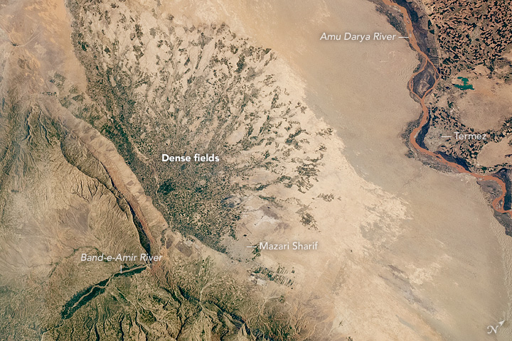
, official_name = , settlement_type = City , image_skyline = , pushpin_map = Afghanistan#Bactria#West Asia , pushpin_label = Mazar-i-Sharif , pushpin_label_position = bottom , pushpin_mapsize = , pushpin_relief = yes , pushpin_map_caption = Location in Afghanistan , coordinates = , subdivision_type = Country , subdivision_name = Afghanistan , subdivision_type1 = Province , subdivision_type2 = District , subdivision_name1 = Balkh Province , subdivision_name2 = Mazar-i-Sharif District , established_title = , established_date = , leader_title = Mayor , leader_name = Abdullhaq Khurami , area_total_km2 = , area_land_km2 ... [...More Info...] [...Related Items...] OR: [Wikipedia] [Google] [Baidu] |
Guzgan
Guzgan ( fa, گوزگان, also known as Gozgan, Guzganan or Quzghan, in Arabic Juzjan or Juzjanan) was a historical region and early medieval principality in what is now northern Afghanistan. Etymology The area was known as "Guzgan" or in the plural form "Guzganan", whence Arabic "Juzjan"/"Juzjanan". Orientalist Vladimir Minorsky derived the name from a word meaning "walnut", a product for which the area is still known today. The 19th-century scholar Henry George Raverty suggested that the plural form emerged from the division of the country in two parts by the river Murghab. Geography The boundaries of Guzgan were never well defined and fluctuated wildly over time. They certainly bear no relation to the modern administrative boundaries of Jowzjan Province, named after it, or the neighbouring Faryab Province, but historically included the lands around the towns of Maymana (capital of Faryab province), Andkhuy, Shibarghan (capital of Jowzjan Province) and Sar-e Pol (capital ... [...More Info...] [...Related Items...] OR: [Wikipedia] [Google] [Baidu] |
Kandahar
Kandahar (; Kandahār, , Qandahār) is a List of cities in Afghanistan, city in Afghanistan, located in the south of the country on the Arghandab River, at an elevation of . It is Afghanistan's second largest city after Kabul, with a population of about 614,118. It is the capital of Kandahar Province as well as the de facto capital of the Taliban, formally known as the Islamic Emirate of Afghanistan. It also happens to be the centre of the larger cultural region called Loy Kandahar. In 1709, Mirwais Hotak made the region an independent kingdom and turned Kandahar into the capital of the Hotak dynasty. In 1747, Ahmad Shah Durrani, founder of the Durrani dynasty, made Kandahar the capital of the Durrani Empire, Afghan Empire. Historically this province is considered as important political area for Afghanistan revelations. Kandahar is one of the most culturally significant cities of the Pashtun people, Pashtuns and has been their traditional seat of power for more than 300 years. ... [...More Info...] [...Related Items...] OR: [Wikipedia] [Google] [Baidu] |
Zunbils
Zunbil, also written as Zhunbil, or Rutbils of Zabulistan, was a royal dynasty south of the Hindu Kush in present southern Afghanistan region. They ruled from circa 680 AD until the Saffarid conquest in 870 AD. The Zunbil dynasty was founded by Rutbil (Turkic: ''Iltäbär''), the elder brother of the Turk Shahi ruler (either Barha Tegin or Tegin Shah), who ruled over a Khalaj - Hephthalite kingdom from his capital in Kabul.Andre Wink, '' Al-Hind, the Making of the Indo-Islamic World'', Vol.1, (Brill, 1996), 115;"''"The Zunbils of the early Islamic period and the Kabulshahs were almost certainly epigoni of the southern-Hephthalite rulers of Zabul.''" The Zunbils are described as having Turkish troops in their service by Arabic sources like Tarikh al-Tabari and ''Tarikh-i Sistan''. The faith of this community has not been researched as much. According to the interpretation of Chinese sources by Marquarts and de Groots in 1915, the king of Ts'ao is said to have worn a crown with a ... [...More Info...] [...Related Items...] OR: [Wikipedia] [Google] [Baidu] |
Kabul
Kabul (; ps, , ; , ) is the capital and largest city of Afghanistan. Located in the eastern half of the country, it is also a municipality, forming part of the Kabul Province; it is administratively divided into 22 municipal districts. According to late 2022 estimates, the population of Kabul was 13.5 million people. In contemporary times, the city has served as Afghanistan's political, cultural, and economical centre, and rapid urbanisation has made Kabul the 75th-largest city in the world and the country's primate city. The modern-day city of Kabul is located high up in a narrow valley between the Hindu Kush, and is bounded by the Kabul River. At an elevation of , it is one of the highest capital cities in the world. Kabul is said to be over 3,500 years old, mentioned since at least the time of the Achaemenid Persian Empire. Located at a crossroads in Asia—roughly halfway between Istanbul, Turkey, in the west and Hanoi, Vietnam, in the east—it is situated in a stra ... [...More Info...] [...Related Items...] OR: [Wikipedia] [Google] [Baidu] |
Ghazni
Ghazni ( prs, غزنی, ps, غزني), historically known as Ghaznain () or Ghazna (), also transliterated as Ghuznee, and anciently known as Alexandria in Opiana ( gr, Αλεξάνδρεια Ωπιανή), is a city in southeastern Afghanistan with a population of around 190,000 people. The city is strategically located along Highway 1, which has served as the main road between Kabul and Kandahar for thousands of years. Situated on a plateau at 2,219 metres (7,280 ft) above sea level, the city is south of Kabul and is the capital of Ghazni Province. Ghazni Citadel, the Minarets of Ghazni, the Palace of Sultan Mas'ud III, and several other cultural heritage sites have brought travelers and archeologists to the city for centuries. During the pre-Islamic period, the area was inhabited by various tribes who practiced different religions including Zoroastrianism, Buddhism and Hinduism. Arab Muslims introduced Islam to Ghazni in the 7th century and were followed in the 9th ... [...More Info...] [...Related Items...] OR: [Wikipedia] [Google] [Baidu] |
Qobadian
Qubodiyon, also Qubadiyan, ancient Kobadiyan (russian: Кабодиён; tg, Қубодиён, fa, قبادیان ''Qobādiyān'') is a town in the Khatlon Region of Tajikistan. It is the capital of Qubodiyon District. The population of the town is 12,200 (January 2020 estimate). Qubodiyon was possibly founded by the Sasanian king Kavad I () during his exile in the Hephthalite Empire, where the town possibly served as his source of revenue. Nasir Khusraw, a Persian poet, philosopher, Isma'ili scholar, traveler and one of the greatest writers in Persian literature was born in the village in 1004 CE. The Oxus Treasure was found near Kobadiyan."East of Termez, on the Kafirnigan River, on the territory of Tajikistan, lies the small town of Kobadiyan, near which was found in the late 1870s one of the most famous treasures of all time, the so - called treasure of Oxus." in File:Kabadiyan ambassador to the Southern Liang court 516-520 CE.jpg, Kabadiyan ambassador to the Chinese co ... [...More Info...] [...Related Items...] OR: [Wikipedia] [Google] [Baidu] |
Badakhshan
Badakhshan is a historical region comprising parts of modern-day north-eastern Afghanistan, eastern Tajikistan, and Taxkorgan Tajik Autonomous County in China. Badakhshan Province is one of the 34 provinces of Afghanistan. Much of historic Badakhshan lies within Tajikistan's Gorno-Badakhshan Autonomous Region, in the southeastern part of the country. The music of Badakhshan is an important part of the region's cultural heritage. Name The name "Badakhshan" ( fa, بدخشان, ''Badaxšân''; ps, بدخشان; tg, Бадахшон, ''Badaxşon''; ) is derived from the Sasanian official title ''bēdaxš'' or ''badaxš'', which may be from an earlier *pati-axša; the suffix -''ān'' indicates that the country belonged, or had been assigned as a fief, to a person holding the rank of a '' badaxš''. People Badakhshan has a diverse ethnolinguistic and religious community. Tajiks and Pamiris are the majority while a tiny minority of Kyrgyzs and Uzbeks also are found in their ... [...More Info...] [...Related Items...] OR: [Wikipedia] [Google] [Baidu] |
Bamiyan
Bamyan or Bamyan Valley (); ( prs, بامیان) also spelled Bamiyan or Bamian is the capital of Bamyan Province in central Afghanistan. Its population of approximately 70,000 people makes it the largest city in Hazarajat. Bamyan is at an altitude of about above sea level. The Bamyan Airport is located in the middle of the city. The driving distance between Bamyan and Kabul in the southeast is approximately . The Band-e-Amir National Park is to the west, about a half-hour drive from the city of Bamyan. Bamyan is referred to by some as the "Shining Light" and "Valley of Gods". There are several tourist attractions near the city, including the Buddhas of Bamyan, which were carved into cliffs on the north side of Bamyan city in the 6th and 7th century CE, dating them to the Hephthalite rule. Other attractions close to the city include Shahr-e Gholghola and Zuhak. In 2008, Bamyan was found to be the home of the world's oldest oil paintings. At the end of the 10th century, there ... [...More Info...] [...Related Items...] OR: [Wikipedia] [Google] [Baidu] |

.jpg)


