|
Wita-wattingga
Seacliff Park is a suburb of Adelaide partly in the City of Marion and the City of Holdfast Bay. The suburb is adjacent to South Brighton in the north, Seaview Downs to the east, Hallett Cove to the south, and Marino and Seacliff on its western side. The suburb is divided diagonally by Ocean Road, with the northern part of the suburb mainly residential, and the southern park partly occupied by a golf course and a quarry. Prior to the 1836 British colonisation of South Australia, the area was inhabited by the Kaurna people, who occupied the land from Cape Jervis in the south up the western side of the Fleurieu Peninsula, to Crystal Brook in the north, west to the Mount Lofty Ranges, across to Gulf Saint Vincent, including the Adelaide Plains and city of Adelaide. The Kaurna name for the area was Wita-wattingga, or Wita-wita, was the Kaurna name of an area on the north side of O'Halloran Hill, which was then covered in low woodland of ''Eucalyptus porosa'' and/or '' Euca ... [...More Info...] [...Related Items...] OR: [Wikipedia] [Google] [Baidu] |
Seacliff, South Australia
Seacliff is a coastal suburb located in the capital city of South Australia; Adelaide. Overseen by the council, City of Holdfast Bay, this suburb is adjacent to South Brighton, Seacliff Park, Marino and Kingston Park. Seacliff Post Office opened on 1 July 1915 and closed in 1978. History Heritage listings The suburb of Seacliff has an extensive list of heritage listed locations all deemed to have historical value. The Seacliff Hotel built in 1927, originally named the Hotel Australia and renamed in 1935, was proposed to be heritage listed in 1998. It received great publicity for being the headquarters for the English Test Cricketers during the Adelaide Test in the 1935 and 1936 tour. The Brighton and Seacliff Yacht Club formed in 1919, and later had its clubrooms built in 1927 after land was purchased by Tom Mayfield Hardy. It became home club to nationally and internationally renowned yachtsmen Sir James Hardy, and in 1966 hosted the 505 World Championships. Eur ... [...More Info...] [...Related Items...] OR: [Wikipedia] [Google] [Baidu] |
O'Halloran Hill, South Australia
O'Halloran Hill is a suburb in the south of Adelaide, South Australia, situated on the hills south of the O'Halloran Hill Escarpment, which rises from the Adelaide Plains and located 18 km from the city centre via the Main South Road. The suburb is split between the Cities of Marion and Onkaparinga, and it neighbours Happy Valley, Hallett Cove, Trott Park and Darlington. It includes a large area of farmland and commercial vineyards known as the Glenthorne Estate. History Before British colonisation of South Australia, ''Kaurna Yerta Parngkarra'' (Kaurna tribal country) stretched from Cape Jervis in the south, to Crystal Brook in the north, west to the Mount Lofty Ranges, across to Gulf Saint Vincent, including the plains and city of Adelaide. An area on the north side of the hill was known as Wita-wattingga, meaning "in the midst of peppermint gums", as it was then covered in low woodland of ''Eucalyptus porosa'' and/or ''Eucalyptus odorata'', known as mallee pepper ... [...More Info...] [...Related Items...] OR: [Wikipedia] [Google] [Baidu] |
Electoral District Of Black
Black is a single-member electoral district for the South Australian House of Assembly. It was created by the redistribution conducted in 2016, and was contested for the first time at the 2018 state election. Black is named after Dorrit Black (Dorothea Foster Black, 1891–1951), a South Australian modern artist, best known for linocuts, oil and watercolour paintings. Black lies south-west of the Adelaide city centre and includes the suburbs of Darlington, Hallett Cove, Kingston Park, Marino, O'Halloran Hill, Seacliff, Seacliff Park, Seacombe Heights, Seaview Downs, Sheidow Park and Trott Park. At its creation, Black was projected to be notionally held by the Liberal Party with a swing of 2.6% required to lose it. The 2018 creation of Black replaced the electorate of Mitchell that was disestablished at the 2018 state election. Black does not extend as far north or south as Mitchell did, but extends west to the coast through part of what used to be Bright. Members for Blac ... [...More Info...] [...Related Items...] OR: [Wikipedia] [Google] [Baidu] |
Fleurieu Peninsula
The Fleurieu Peninsula () is a peninsula in the Australian state of South Australia located south of the state capital of Adelaide. History Before British colonisation of South Australia, the western side of the peninsula was occupied by the Kaurna people, while several clans of the Ngarrindjeri lived on the eastern side. The people were sustained by the flora and fauna of the peninsula, for food and bush medicine. The bulrushes, reeds and sedges were used for basket-weaving or making rope, trees provided wood for spears, and stones were fashioned into tools. The Fleurieu Peninsula was named after Charles Pierre Claret de Fleurieu, the French explorer and hydrographer, by the French explorer Nicolas Baudin as he explored the south coast of Australia in 1802. The name came into official use in 1911 after Fleurieu's great-nephew, Count Alphonse de Fleurieu, visited Adelaide and met with the Council of the Royal Geographical Society of South Australia, which recommended to t ... [...More Info...] [...Related Items...] OR: [Wikipedia] [Google] [Baidu] |
University Of Adelaide
The University of Adelaide (informally Adelaide University) is a public research university located in Adelaide, South Australia. Established in 1874, it is the third-oldest university in Australia. The university's main campus is located on North Terrace in the Adelaide city centre, adjacent to the Art Gallery of South Australia, the South Australian Museum, and the State Library of South Australia. The university has four campuses, three in South Australia: North Terrace campus in the city, Roseworthy campus at Roseworthy and Waite campus at Urrbrae, and one in Melbourne, Victoria. The university also operates out of other areas such as Thebarton, the National Wine Centre in the Adelaide Park Lands, and in Singapore through the Ngee Ann-Adelaide Education Centre. The University of Adelaide is composed of three faculties, with each containing constituent schools. These include the Faculty of Sciences, Engineering and Technology (SET), the Faculty of Health and Medical S ... [...More Info...] [...Related Items...] OR: [Wikipedia] [Google] [Baidu] |
Rapid Bay
Rapid Bay is a locality that includes a small seaside town and bay on the west coast of the Fleurieu Peninsula, South Australia. It lies within the District Council of Yankalilla and its township is approximately 100 km south of the state capital, Adelaide. A pair of jetties are popular attractions for recreational fishing, scuba diving and snorkelling. The bay particularly known as a site for observing leafy seadragons in the wild. Its postcode is 5204. History Rapid Bay features in the creation myths of the Kaurna and Ramindjeri peoples most notably as the burial site of the nephew of the Kaurna creator ancestor known as Tjilbruke. There is uncertainty as to the Kaurna name for Rapid Bay, which has been cited as Patparno, Patpangga (meaning "south" or "south place"), and Yarta-kulangga, a popular campsite at Rapid Bay, whose name probably means "place of the separate country". However there is no evidence that any of these names was a place name for Rapid Bay, though ... [...More Info...] [...Related Items...] OR: [Wikipedia] [Google] [Baidu] |
Main South Road
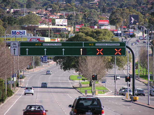
South Road and its southern section as Main South Road outside of Adelaide is a major north–south conduit connecting Adelaide and the Fleurieu Peninsula, in South Australia. It is one of Adelaide's most important arterial and bypass roads. As South Road, it is designated part of route A2 within suburban Adelaide, and as Main South Road, it is designated part of routes A13 and B23. The northern part of South Road contributes the central component of the North–South Corridor, a series of road projects under construction or planning that will eventually provide a continuous expressway between Old Noarlunga and Gawler. Route South Road commences from the intersection with Port River Expressway and Salisbury Highway in Wingfield and runs directly south, through much of Adelaide's inner western suburbs, close to the Adelaide city centre; it is complimented by (and in some instances, subsumed into) the North-South Motorway and either runs directly underneath it at ground level w ... [...More Info...] [...Related Items...] OR: [Wikipedia] [Google] [Baidu] |
Eucalyptus Odorata
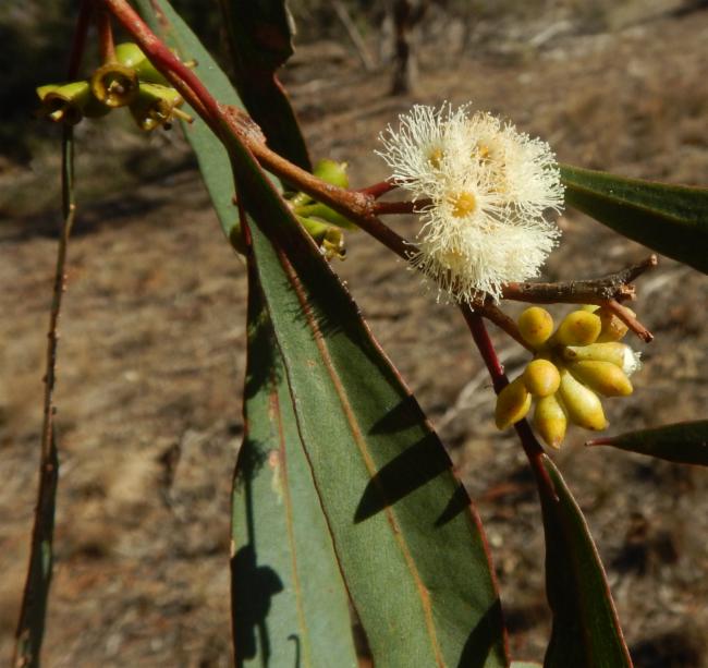
''Eucalyptus odorata'', commonly known as peppermint box, is a species of mallee or a small tree that is endemic to South Australia. It has rough, hard bark on the trunk and larger branches, smooth greyish bark on the thinner branches, lance-shaped adult leaves, flower buds in groups of between seven and eleven, white flowers and cylindrical or barrel-shaped fruit. Description ''Eucalyptus odorata'' is a mallee or small tree that typically grows to a height of and forms a lignotuber. It has rough, hard, fissured bar on the trank and branches thicker than , smooth, grey or brownish bark above. Young plants and coppice regrowth have lance-shaped leaves that are long and wide. Adult leaves are the same shade of glossy green on both sides when mature, lance-shaped, long and wide, tapering to a petiole long. The flower buds are arranged in leaf axils in groups of seven, nine or eleven on an unbranched peduncle, the individual buds sessile or on pedicels up to long. Mature bud ... [...More Info...] [...Related Items...] OR: [Wikipedia] [Google] [Baidu] |
Eucalyptus Porosa
''Eucalyptus porosa'', commonly known as mallee box, Quorn mallee or water mallee, is a species of mallee or a tree that is endemic to southern Australia. It has rough, fibrous or flaky bark on the trunk and larger branches, smooth greyish bark above, lance-shaped adult leaves, flower buds in groups of seven, white flowers and barrel-shaped or shortened spherical fruit. Description ''Eucalyptus porosa'' is a mallee that typically grows to a height of , or a tree to , and forms a lignotuber. It has rough, fibrous or flaky, greyish bark on the trunk or stems, smooth whitish or grey bark above. Young plant and coppice Coppicing is a traditional method of woodland management which exploits the capacity of many species of trees to put out new shoots from their stump or roots if cut down. In a coppiced wood, which is called a copse, young tree stems are repeate ... regrowth have egg-shaped to lance-shaped leaves that are long and wide. Adult leaves are the same shade of glossy g ... [...More Info...] [...Related Items...] OR: [Wikipedia] [Google] [Baidu] |
Woodland
A woodland () is, in the broad sense, land covered with trees, or in a narrow sense, synonymous with wood (or in the U.S., the ''plurale tantum'' woods), a low-density forest forming open habitats with plenty of sunlight and limited shade (see differences between British, American, and Australian English explained below). Woodlands may support an understory of shrubs and herbaceous plants including grasses. Woodland may form a transition to shrubland under drier conditions or during early stages of primary or secondary succession. Higher-density areas of trees with a largely closed canopy that provides extensive and nearly continuous shade are often referred to as forests. Extensive efforts by conservationist groups have been made to preserve woodlands from urbanization and agriculture. For example, the woodlands of Northwest Indiana have been preserved as part of the Indiana Dunes. Definitions United Kingdom ''Woodland'' is used in British woodland management to mean tre ... [...More Info...] [...Related Items...] OR: [Wikipedia] [Google] [Baidu] |
The University Of Adelaide
The University of Adelaide (informally Adelaide University) is a public research university located in Adelaide, South Australia. Established in 1874, it is the third-oldest university in Australia. The university's main campus is located on North Terrace in the Adelaide city centre, adjacent to the Art Gallery of South Australia, the South Australian Museum, and the State Library of South Australia. The university has four campuses, three in South Australia: North Terrace campus in the city, Roseworthy campus at Roseworthy and Waite campus at Urrbrae, and one in Melbourne, Victoria. The university also operates out of other areas such as Thebarton, the National Wine Centre in the Adelaide Park Lands, and in Singapore through the Ngee Ann-Adelaide Education Centre. The University of Adelaide is composed of three faculties, with each containing constituent schools. These include the Faculty of Sciences, Engineering and Technology (SET), the Faculty of Health and Medical Sci ... [...More Info...] [...Related Items...] OR: [Wikipedia] [Google] [Baidu] |
Adelaide City Centre
Adelaide city centre (Kaurna: Tarndanya) is the inner city locality of Greater Adelaide, the capital city of South Australia. It is known by locals simply as "the City" or "Town" to distinguish it from Greater Adelaide and from the City of Adelaide local government area (which also includes North Adelaide and from the Park Lands around the whole city centre). The population was 15,115 in the . Adelaide city centre was planned in 1837 on a greenfield site following a grid layout, with streets running at right angles to each other. It covers an area of and is surrounded by of park lands.The area of the park lands quoted is based, in the absence of an official boundary between the City and North Adelaide, on an east–west line past the front entrance of Adelaide Oval. Within the city are five parks: Victoria Square in the exact centre and four other, smaller parks. Names for elements of the city centre are as follows: *The "city square mile" (in reality 1.67 square miles ... [...More Info...] [...Related Items...] OR: [Wikipedia] [Google] [Baidu] |


