|
Vilniansk
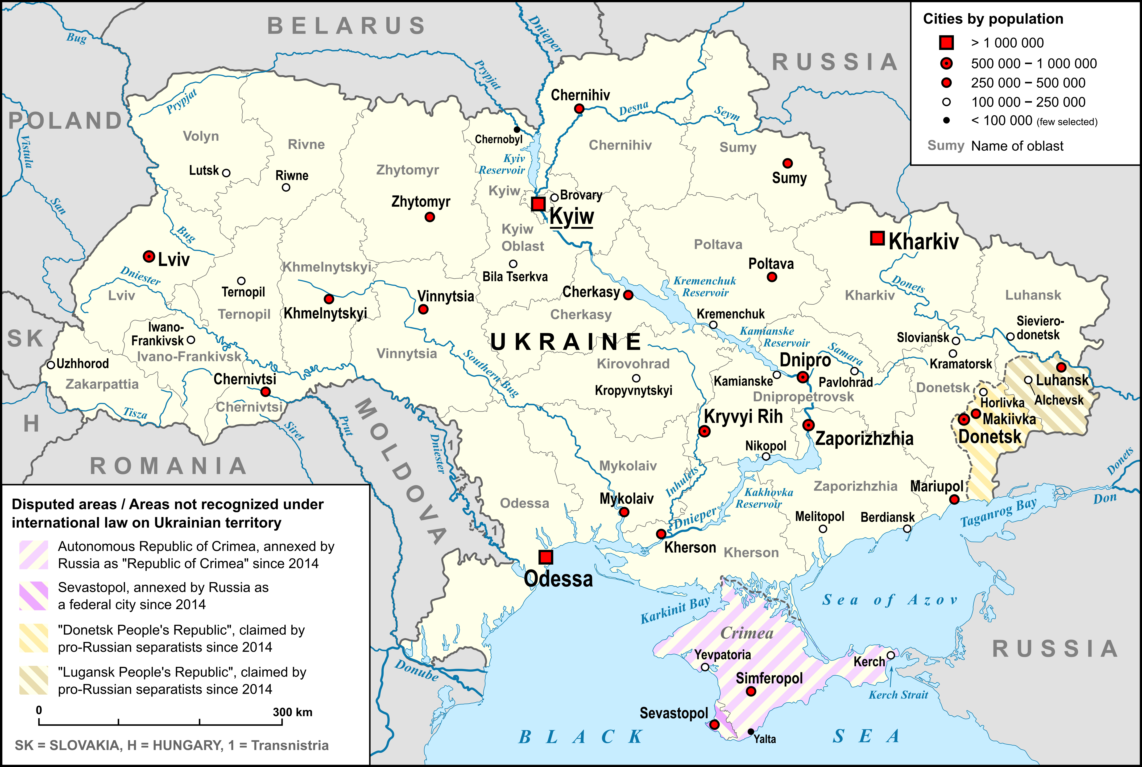
Vilniansk ( uk, Вільня́нськ, ; russian: Вольнянск, Volnyansk, ) is a city in Zaporizhzhia Oblast, Ukraine and the administrative center of Vilniansk urban hromada. Population: It was the administrative center of Vilniansk Raion (district) until 2020, when the raion was abolished in accordance with administrative reforms and its area merged into Zaporizhzhia Raion Zaporizhzhia Raion ( uk, Запорізький район, ) is one of the 5 raions (districts) of Zaporizhzhia Oblast in southeast Ukraine. The administrative center of the raion is located in the city of Zaporizhzhia. Population: According to .... Gallery File:Вільнянськ-промисловість.JPG, Industrial enterprise in Vilniansk File:С. зелене-вільнянка.JPG, Vilnianka River References Cities in Zaporizhzhia Oblast Cities of district significance in Ukraine Populated places established in the Russian Empire Zaporizhzhia Raion {{Zaporizhzhia-g ... [...More Info...] [...Related Items...] OR: [Wikipedia] [Google] [Baidu] |
Vilniansk Raion
Vilniansk Raion ( uk, Вільнянський район) was one of raions (districts) of Zaporizhzhia Oblast in southern Ukraine. The administrative center of the region was the town of Vilniansk. The raion was abolished on 18 July 2020 as part of the administrative reform of Ukraine, which reduced the number of raions of Zaporizhzhia Oblast to five.The area of Vilniansk Raion was merged into Zaporizhzhia Raion Zaporizhzhia Raion ( uk, Запорізький район, ) is one of the 5 raions (districts) of Zaporizhzhia Oblast in southeast Ukraine. The administrative center of the raion is located in the city of Zaporizhzhia. Population: According to .... The last estimate of the raion population was . References Former raions of Zaporizhzhia Oblast 1924 establishments in Ukraine Ukrainian raions abolished during the 2020 administrative reform {{Zaporizhzhia-geo-stub ... [...More Info...] [...Related Items...] OR: [Wikipedia] [Google] [Baidu] |
Vilniansk Urban Hromada
Vilniansk urban hromada () is a hromada of Ukraine, located in Zaporizhzhia Raion, Zaporizhzhia Oblast. Its administrative center is the city Vilniansk. It has an area of and a population of 16,822, as of 2020. The hromada contains 16 settlements: 1 city (Vilniansk) and 15 villages: See also * List of hromadas of Ukraine This is a list of all 1,469 hromadas of Ukraine that were formed in 2020 (excluding Kyiv, Sevastopol and hromadas in the Autonomous Republic of Crimea). A hromada is designated ''urban hromada'' if its administration is located in a city; ''settle ... References {{Zaporizhzhia Oblast Hromadas of Zaporizhzhia Oblast 2020 establishments in Ukraine States and territories established in 2020 ... [...More Info...] [...Related Items...] OR: [Wikipedia] [Google] [Baidu] |
Zaporizhzhia Oblast
Zaporizhzhia Oblast ( uk, Запорі́зька о́бласть, translit=Zaporizka oblast), also referred to as Zaporizhzhia ( uk, Запорі́жжя, links=no), is an oblast (province) of southeast Ukraine. Its capital is Zaporizhzhia. The oblast covers an area of , and its population is . This oblast is an important part of Ukraine's industry and agriculture. Most of the area of the oblast has been under Russian military occupation since the 2022 Russian invasion of Ukraine, including all of the coast, although the capital and the majority of the population remains under Ukrainian administration. On 30 September 2022 Russia annexed the Donetsk (Donetsk People's Republic), Luhansk (Luhansk People's Republic), Zaporizhzhia, and Kherson Oblasts. However, the referendums and subsequent annexations are internationally unrecognized. Geography The area of the oblast is 27,183 km²; its population (estimated as of 1 January 2013) was 1,785,243. Important cities Import ... [...More Info...] [...Related Items...] OR: [Wikipedia] [Google] [Baidu] |
Zaporizhzhia Raion
Zaporizhzhia Raion ( uk, Запорізький район, ) is one of the 5 raions (districts) of Zaporizhzhia Oblast in southeast Ukraine. The administrative center of the raion is located in the city of Zaporizhzhia. Population: According to the 2001 census, its population was 54,804. On 18 July 2020, as part of the administrative reform of Ukraine, the number of raions of Zaporizhzhia Oblast was reduced to five, and the area of Zaporizhzhia Raion was significantly expanded. The January 2020 estimate of the raion population was Geography Zaporizhzhia Raion is located in the northeast portion of Zaporizhzhia Oblast, surrounding the oblast's administrative center Zaporizhzhia. Its total area constitutes . The Dnieper and Konka Rivers flow through the raion. History The territory which is now the Zaporizhzhia Raion was first established as the Voznesenskyi Raion ( uk, Вознесенський район) on 7 March 1923 as part of a full-scale administrative reorganizatio ... [...More Info...] [...Related Items...] OR: [Wikipedia] [Google] [Baidu] |
List Of Cities In Ukraine
This is a complete list of cities in Ukraine. On 1 January 2022, there were 461 cities ( uk, місто, ''misto'') in Ukraine. City status is granted by the Verkhovna Rada, the Ukrainian parliament. The city status is only partially related to the size of a populated place in Ukraine. Smaller settlements are urban-type settlements (comparable to towns in English-speaking countries) and villages ( uk, село, ''selo''). Historically, there were systems of city rights, granted by the territorial lords, which defined the status of a place as a ''misto'' or ''selo''. Cities were self-governing and had several privileges. The list of cities is ordered by 2021 estimates of population and compared to the 2001 Ukrainian Census, except for Chernobyl for which population is an unofficial estimate. The cities with special status are shown in ''italic''. Cities in Ukraine Jump to table of cities See also * Geography ... [...More Info...] [...Related Items...] OR: [Wikipedia] [Google] [Baidu] |
List Of Sovereign States
The following is a list providing an overview of sovereign states around the world with information on their status and recognition of their sovereignty. The 206 listed states can be divided into three categories based on membership within the United Nations System: 193 UN member states, 2 UN General Assembly non-member observer states, and 11 other states. The ''sovereignty dispute'' column indicates states having undisputed sovereignty (188 states, of which there are 187 UN member states and 1 UN General Assembly non-member observer state), states having disputed sovereignty (16 states, of which there are 6 UN member states, 1 UN General Assembly non-member observer state, and 9 de facto states), and states having a special political status (2 states, both in free association with New Zealand). Compiling a list such as this can be a complicated and controversial process, as there is no definition that is binding on all the members of the community of nations concerni ... [...More Info...] [...Related Items...] OR: [Wikipedia] [Google] [Baidu] |
Oblasts Of Ukraine
An oblast ( uk, о́бласть; ) in Ukraine, often called a region or province, is the main type of first-level administrative division of the country. Ukraine's territory is divided into 24 oblasts, as well as one autonomous republic, Crimea, and two cities with special status, Kyiv and Sevastopol. Ukraine is a unitary state, thus the oblasts do not have much legal scope of competence other than that which is established in the Ukrainian Constitution and by law. Articles 140–146 of Chapter XI of the constitution deal directly with local authorities and their competency. Oblasts are subdivided into raions (districts), each oblast having from 3 to 10 raions following the July 2020 reform. General characteristics In Ukraine, the term ''oblast'' denotes a primary administrative division. Under the Russian Empire and into the 1920s, Ukraine was divided between several governorates. The term ''oblast'' was introduced in 1932 by Soviet authorities when the Ukrainian SSR was ... [...More Info...] [...Related Items...] OR: [Wikipedia] [Google] [Baidu] |
Raions Of Ukraine
Raions of Ukraine (often translated as "districts"; Ukrainian: ра́йон, tr. ''raion''; plural: райо́ни, tr. ''raiony'') are the second level of administrative division in Ukraine, below the oblast. Raions were created in a 1922 administrative reform of the Soviet Union, to which Ukraine, as the Ukrainian Soviet Socialist Republic, belonged. On 17 July 2020, the Verkhovna Rada (Ukraine's parliament) approved an administrative reform to merge most of the 490 raions, along with the "cities of regional significance", which were previously outside the raions, into just 136 reformed raions. Most tasks of the raions (education, healthcare, sport facilities, culture, and social welfare) were taken over by new hromadas, the subdivisions of raions. [...More Info...] [...Related Items...] OR: [Wikipedia] [Google] [Baidu] |
Mayor
In many countries, a mayor is the highest-ranking official in a municipal government such as that of a city or a town. Worldwide, there is a wide variance in local laws and customs regarding the powers and responsibilities of a mayor as well as the means by which a mayor is elected or otherwise mandated. Depending on the system chosen, a mayor may be the chief executive officer of the municipal government, may simply chair a multi-member governing body with little or no independent power, or may play a solely ceremonial role. A mayor's duties and responsibilities may be to appoint and oversee municipal managers and employees, provide basic governmental services to constituents, and execute the laws and ordinances passed by a municipal governing body (or mandated by a state, territorial or national governing body). Options for selection of a mayor include direct election by the public, or selection by an elected governing council or board. The term ''mayor'' shares a linguistic ... [...More Info...] [...Related Items...] OR: [Wikipedia] [Google] [Baidu] |
Postal Code
A postal code (also known locally in various English-speaking countries throughout the world as a postcode, post code, PIN or ZIP Code) is a series of letters or digits or both, sometimes including spaces or punctuation, included in a postal address for the purpose of sorting mail. the Universal Postal Union lists 160 countries which require the use of a postal code. Although postal codes are usually assigned to geographical areas, special codes are sometimes assigned to individual addresses or to institutions that receive large volumes of mail, such as government agencies and large commercial companies. One example is the French CEDEX system. Terms There are a number of synonyms for postal code; some are country-specific; * CAP: The standard term in Italy; CAP is an acronym for ''codice di avviamento postale'' (postal expedition code). * CEP: The standard term in Brazil; CEP is an acronym for ''código de endereçamento postal'' (postal addressing code). * Eircode: Th ... [...More Info...] [...Related Items...] OR: [Wikipedia] [Google] [Baidu] |
Köppen Climate Classification
The Köppen climate classification is one of the most widely used climate classification systems. It was first published by German-Russian climatologist Wladimir Köppen (1846–1940) in 1884, with several later modifications by Köppen, notably in 1918 and 1936. Later, the climatologist Rudolf Geiger (1894–1981) introduced some changes to the classification system, which is thus sometimes called the Köppen–Geiger climate classification system. The Köppen climate classification divides climates into five main climate groups, with each group being divided based on seasonal precipitation and temperature patterns. The five main groups are ''A'' (tropical), ''B'' (arid), ''C'' (temperate), ''D'' (continental), and ''E'' (polar). Each group and subgroup is represented by a letter. All climates are assigned a main group (the first letter). All climates except for those in the ''E'' group are assigned a seasonal precipitation subgroup (the second letter). For example, ''Af'' indi ... [...More Info...] [...Related Items...] OR: [Wikipedia] [Google] [Baidu] |
Humid Continental Climate
A humid continental climate is a climatic region defined by Russo-German climatologist Wladimir Köppen in 1900, typified by four distinct seasons and large seasonal temperature differences, with warm to hot (and often humid) summers and freezing cold (sometimes severely cold in the northern areas) winters. Precipitation is usually distributed throughout the year but often do have dry seasons. The definition of this climate regarding temperature is as follows: the mean temperature of the coldest month must be below or depending on the isotherm, and there must be at least four months whose mean temperatures are at or above . In addition, the location in question must not be semi-arid or arid. The cooler ''Dfb'', ''Dwb'', and ''Dsb'' subtypes are also known as hemiboreal climates. Humid continental climates are generally found between latitudes 30° N and 60° N, within the central and northeastern portions of North America, Europe, and Asia. They are rare and isolat ... [...More Info...] [...Related Items...] OR: [Wikipedia] [Google] [Baidu] |
.png)


