|
Vayegi
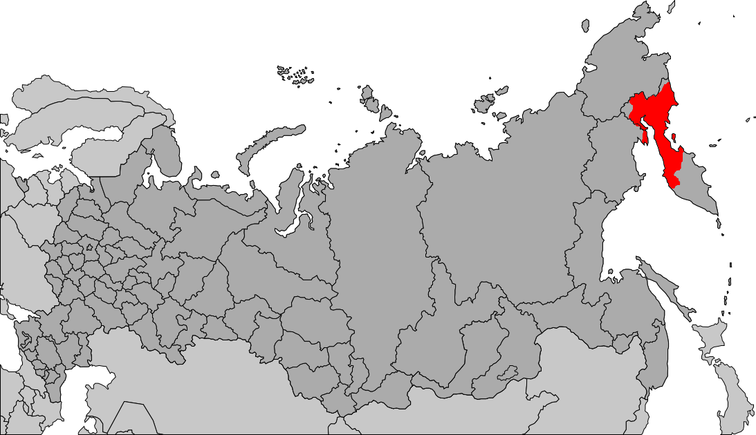
Vayegi (russian: Вае́ги; ckt, Вааргын, ''Vaargyn''; Koryak: Ваевви, ''Vaevvi'') is a rural locality (a '' selo'') in Anadyrsky District of Chukotka Autonomous Okrug, Russia, located near the border with Kamchatka Krai, on the banks of the river Mayn, southwest of Anadyr, the administrative center of the autonomous okrug. As of the 2010 Census, its population was 497.The results of the 2010 Census are given for Vayegi Rural Settlement, a municipal formation of Anadyrsky Municipal District. According to Law #148-OZ, Vayegi is the only inhabited locality on the territory of Vayegi Rural Settlement. History It was founded in 1951 as a result of the ongoing Soviet policy of collectivization. The kolkhoz (collective farm) that was founded around Vayegi brought together several groups of previously nomadic herders, including the more remote settlements of Beryozovo and the old settlement of Vayegi, which both became abandoned. After the dissolution of the So ... [...More Info...] [...Related Items...] OR: [Wikipedia] [Google] [Baidu] |
Anadyrsky District
Anadyrsky District (russian: Ана́дырский райо́н; Chukchi: , ''Kagyrgyn rajon'') is an administrativeLaw #33-OZ and municipalLaw #148-OZ district (raion), one of the six in Chukotka Autonomous Okrug, Russia. It is located in the central and southern parts of the autonomous okrug and borders with Chaunsky District in the northwest, Iultinsky District in the north and northeast, the Gulf of Anadyr in the east, Koryak Okrug in the south, and with Bilibinsky District in the west and northwest. It also completely surrounds the territory of the town of okrug significance of Anadyr. The area of the district is .Official website of Anadyrsky DistrictGeneral information Its administrative center is the town of Anadyr (which is not administratively a part of the district). Population: In terms of area, this is the largest district in the autonomous okrug. The district is located in a mountainous region, the peaks of which provide the catchment areas for the Anadyr River and ... [...More Info...] [...Related Items...] OR: [Wikipedia] [Google] [Baidu] |
Mayn
The Mayn (russian: Майн; ckt, Мэйнывээм, meaning "The Great River") is a river in Chukotka Autonomous Okrug (Magadan Oblast) in Russia, one of the major tributaries of the Anadyr. The length of the river is . The area of is drainage basin is . Course It flows roughly northwards from its source in the small Maynskoe Lake, located in the northern part of the Parapol Valley, in the Penzhinsky Range of the Koryak Highlands. The river passes then through sparsely populated areas of the forest-tundra subzones of Chukotka. Finally it joins the right bank of the Anadyr. The Mayn meets the Anadyr at Ust-Mayn in the mid-lower stretch of its course, in an area of wetlands and small lakes, about further upstream from the confluence of the Anadyr and the Belaya. All these rivers are frozen for about eight to nine months in a year between mid-October and the end of May. There were ancient settlements in the Mayn basin. In present times Vayegi town lies in the Mayn's middle co ... [...More Info...] [...Related Items...] OR: [Wikipedia] [Google] [Baidu] |
Chukotavia
ChukotAVIA (russian: ЧукотАВИА, short for Чукотские авиалинии; en, Chukotka Airlines) is an airline based in Anadyr, Chukotka Autonomous Okrug, Russia. It operates passenger, cargo, and utility services. Its main base is Anadyr Ugolny Airport. History The airline was established and started operations in 1996. It was formed by the merger of Anadyr and Chaunski Air Enterprises. It is owned by Anadyr Air Enterprise, Keperveyem Air Enterprise, Mys Shmidta Air Enterprise and Pevek Air Enterprise. In 2020, it became part of Russia's single far-eastern airline, along with four other airlines. Fleet As of 2016, the Chukotavia fleet comprises the following aircraft: Fleet upgrade In 2014, Chukotavia leased two DHC-6-400 Twin Otter turboprop aircraft to replace helicopters on its regional flights, with additional two aircraft purchased in 2015. Destinations *Anadyr Ugolny Airport *Beringovsky Airport, Beringovsky *Keperveyem Airport, Bilibino * Kresta Bay ... [...More Info...] [...Related Items...] OR: [Wikipedia] [Google] [Baidu] |
Beryozovo, Chukotka Autonomous Okrug
Beryozovo (russian: Берёзово) is an abandoned selo in the Anadyrsky District of Chukotka Autonomous Okrug in Russia. It was located on the left bank of the Velikaya. In 1949, it was a center of a revolt against the central authority, which was related to forcible collectivization of reindeer herds. In 1951, the whole population of the selo was resettled to Vayegi Vayegi (russian: Вае́ги; ckt, Вааргын, ''Vaargyn''; Koryak: Ваевви, ''Vaevvi'') is a rural locality (a '' selo'') in Anadyrsky District of Chukotka Autonomous Okrug, Russia, located near the border with Kamchatka Krai, on th .... References {{Reflist Anadyrsky District Rural localities in Chukotka Autonomous Okrug Former populated places in Russia ... [...More Info...] [...Related Items...] OR: [Wikipedia] [Google] [Baidu] |
Chukotka Autonomous Okrug
Chukotka (russian: Чуко́тка), officially the Chukotka Autonomous Okrug,, ''Čukotkakèn avtonomnykèn okrug'', is the easternmost federal subjects of Russia, federal subject of Russia. It is an autonomous okrug situated in the Russian Far East, and shares a border with the Sakha, Sakha Republic to the west, Magadan Oblast to the south-west, and Kamchatka Krai to the south. Anadyr (town), Anadyr is the largest types of inhabited localities in Russia, town and the administrative center, capital, and the easternmost settlement to have town status in Russia. Chukotka is primarily populated by ethnic Russians, Chukchi people, Chukchi, and other Indigenous peoples of Siberia, indigenous peoples. It is the only autonomous okrug in Russia that is not included in, or subordinate to, another federal subject, having separated from Magadan Oblast in 1992. It is home to Lake Elgygytgyn, an impact crater lake, and Anyuyskiy, an extinct volcano. The village of Uelen is the easternmos ... [...More Info...] [...Related Items...] OR: [Wikipedia] [Google] [Baidu] |
Boreal Ecosystem
A boreal ecosystem is an ecosystem with a subarctic climate located in the Northern Hemisphere, approximately between 50° to 70°N latitude. These ecosystems are commonly known as taiga and are located in parts of North America, Europe, and Asia. The ecosystems that lie immediately to the south of boreal zones are often called hemiboreal. There are a variety of processes and species that occur in these areas as well. The Köppen symbols of boreal ecosystems are Dfc, Dwc, Dfd, and Dwd. Boreal Species The species within boreal ecosystems varies as it consists of both terrestrial and aquatic habitats. The species composition include many generalized and less specialized feeders. From the equator to the poles, species richness decreases, and there is a negative relationship with species richness changes as climate changes. However, despite not being as biodiverse as tropical systems, this area has a variety of species. Boreal ecosystems are filled with a multitude of flora specie ... [...More Info...] [...Related Items...] OR: [Wikipedia] [Google] [Baidu] |
Subarctic Climate
The subarctic climate (also called subpolar climate, or boreal climate) is a climate with long, cold (often very cold) winters, and short, warm to cool summers. It is found on large landmasses, often away from the moderating effects of an ocean, generally at latitudes from 50° to 70°N, poleward of the humid continental climates. Subarctic or boreal climates are the source regions for the cold air that affects temperate latitudes to the south in winter. These climates represent Köppen climate classification ''Dfc'', ''Dwc'', ''Dsc'', ''Dfd'', ''Dwd'' and ''Dsd''. Description This type of climate offers some of the most extreme seasonal temperature variations found on the planet: in winter, temperatures can drop to below and in summer, the temperature may exceed . However, the summers are short; no more than three months of the year (but at least one month) must have a 24-hour average temperature of at least to fall into this category of climate, and the coldest month should ave ... [...More Info...] [...Related Items...] OR: [Wikipedia] [Google] [Baidu] |
Koryaks
Koryaks () are an indigenous people of the Russian Far East, who live immediately north of the Kamchatka Peninsula in Kamchatka Krai and inhabit the coastlands of the Bering Sea. The cultural borders of the Koryaks include Tigilsk in the south and the Anadyr basin in the north. The Koryaks are culturally similar to the Chukchis of extreme northeast Siberia. The Koryak language and Alutor (which is often regarded as a dialect of Koryak), are linguistically close to the Chukchi language. All of these languages are members of the Chukotko-Kamchatkan language family. They are more distantly related to the Itelmens on the Kamchatka Peninsula. All of these peoples and other, unrelated minorities in and around Kamchatka are known collectively as Kamchadals. Neighbors of the Koryaks include the Evens to the west, the Alutor to the south (on the isthmus of Kamchatka Peninsula), the Kerek to the east, and the Chukchi to the northeast. The Koryak are typically split into two groups ... [...More Info...] [...Related Items...] OR: [Wikipedia] [Google] [Baidu] |
Yaranga
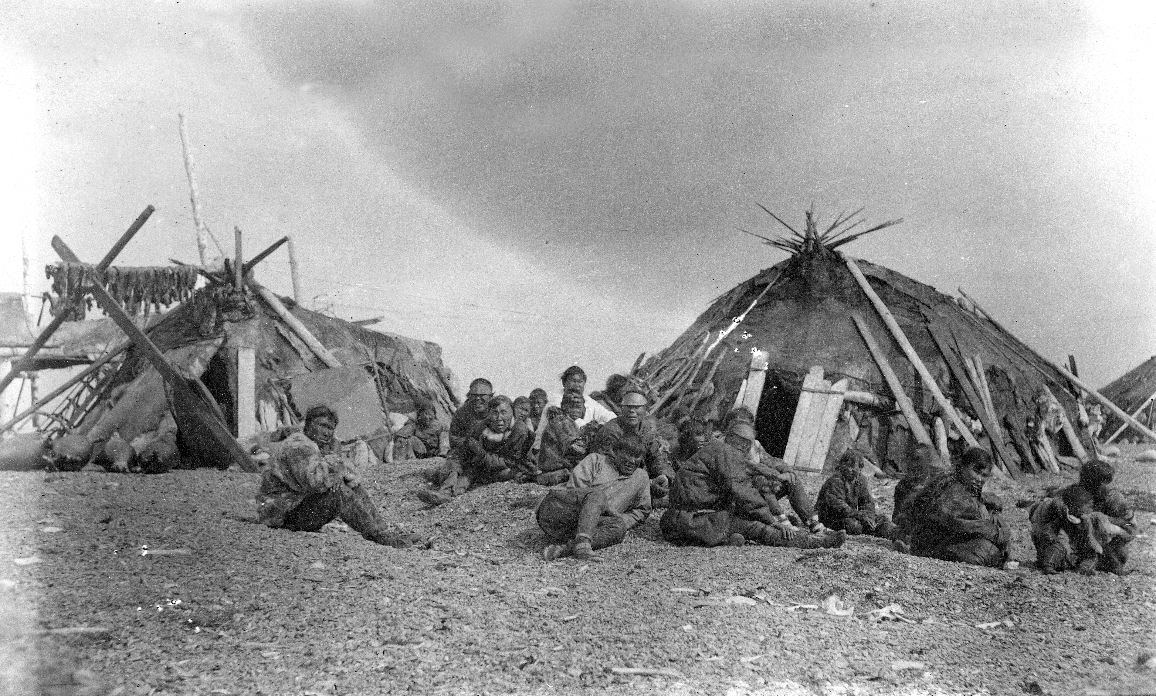
A Yaranga ( Chukchi: ) is a tent-like traditional mobile home of some nomadic Northern indigenous peoples of Russia, such as Chukchi and Siberian Yupik. A Yaranga is a cone-shaped or rounded reindeer-hide tent. It is built of a light wooden frame covered with reindeer skins or canvas sewn together. The word ''yaranga'' comes from the Chukchi word for house: ''jaraŋə'' (Cyrillic: яраӈы). In Russian use, the terms chum, yurt and yaranga may be used interchangeably. Chauchu Chukchi It is built of a light wooden frame covered with reindeer skins sewn together. A medium-size yaranga requires about 50 skins. A large yaranga is hard to completely heat up. There is a smaller cabin called a polog built inside it, that can be kept warm and cozy. Siberian Yupik and Anqallyt Chukchi The most numerous of the Siberian Yupik peoples, the Chaplino Eskimos (Ungazigmit) had a round, dome-shaped building for winter. Literature refers to it as a "yaranga", the same term which th ... [...More Info...] [...Related Items...] OR: [Wikipedia] [Google] [Baidu] |
Kupol Gold Mine
Kupol Gold Mine is a combination underground and open pit gold and silver mine located in the Bilibinsky District of the Chukotka Autonomous Okrug of Russia, at the eastern end of the Anyuy Range. The mine, which produces gold and silver doré bars, is 100% owned by Toronto based Kinross Gold. The name Kupol (russian: купол), literally means "dome". History Development of the mine began in 2005 on a property owned by the Bema Gold Corporation. Bema Gold financed construction through a series of loans totaling $425 million. Bayerische Hypo und Vereinsbank and Société Générale provided $250 million, and $150 million was provided by an international consortium made up of Caterpillar, Export Development Canada, International Finance Corporation, and others. Bema Gold's corporate office loaned the remaining $25 million. In addition to the loans, the government of Chukotka Autonomous Okrug provided an additional $18 million to support construction. In 2007, Kinross purchased ... [...More Info...] [...Related Items...] OR: [Wikipedia] [Google] [Baidu] |
Ugolny Airport
Ugolny Airport (russian: Аэропорт Угольный) (also Leninka, Ugolnyye Kopi, Ugolnoye) is a mixed-use military and civil airfield in the Russian Far East located 11 km east of Anadyr, separated from the town by the waters of Anadyrsky Liman. The airfield was originally constructed in the 1950s as a staging base for Long Range Aviation bombers such as the Tupolev Tu-95 and Tupolev Tu-22M. During the Cold War years it became the primary hub for civilian flights in the Chukotka region. In May 2019, the airport was named in honor of the Chukchi writer Yuri Rytkheu. Civilian history The Soviet-built Ilyushin Il-62 was a workhorse of the route from Moscow Domodedovo Airport to Anadyr for many decades. There is occasional charter aircraft service from Nome, Alaska to Anadyr. Anadyr was featured in the American novel Flight of the Old Dog. In 2018, 102,806 passengers passed through this airport. On 3 January 2020, United States pilot Matt Guthmiller posted a vi ... [...More Info...] [...Related Items...] OR: [Wikipedia] [Google] [Baidu] |
Chukchi People
The Chukchi, or Chukchee ( ckt, Ԓыгъоравэтԓьэт, О'равэтԓьэт, ''Ḷygʺoravètḷʹèt, O'ravètḷʹèt''), are a Siberian indigenous people native to the Chukchi Peninsula, the shores of the Chukchi Sea and the Bering Sea region of the Arctic Ocean all within modern Russia. They speak the Chukchi language. The Chukchi originated from the people living around the Okhotsk Sea. According to several studies on genomic research conduct from 2014 to 2018, the Chukchi are one of the Indigenous peoples of Siberia, they are also the closest Asiatic relatives of the indigenous peoples of the Americas as well as of the Ainu people and other East Asian people, being the descendants of settlers who did not cross the Bering Strait or settled the Japanese archipelago. Cultural history The majority of Chukchi reside within Chukotka Autonomous Okrug, but some also reside in the neighboring Sakha Republic to the west, Magadan Oblast to the southwest, and Kamchatka K ... [...More Info...] [...Related Items...] OR: [Wikipedia] [Google] [Baidu] |


