|
Torwood
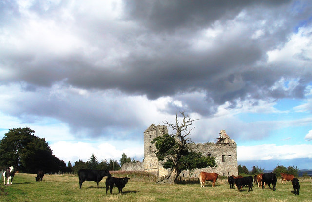
Torwood ( gd, Coille Tor) is a small village located north-northwest of Larbert, north-west of Falkirk and south-southeast of Stirling. Torwood lies within the Falkirk Council area of Scotland. The population recorded in the 2011 UK Census was 245. The A9 road between Bannockburn and Camelon runs through the village. Torwood Has 3 streets: Castle Crescent, Forester Gait & Glen Road. Glen Road leads on to Torwood Castle, Quarry and Broch. History The Forresters used to own the lands of Torwood and Torwood Castle but now a private trust owns the castle. Forrester Gait was named after the family. The Torwood was a large forested area in the 12th century stretching from the River Carron west and north towards Stirling, and inland towards the Campsie Hills. It was traversed by an old Roman Road at this time. In preparation for the Battle of Bannockburn it was used as the encampment for the men of Sir James Douglas, one of the leaders of the army of King Robert the Bruce ... [...More Info...] [...Related Items...] OR: [Wikipedia] [Google] [Baidu] |
Torwood Castle
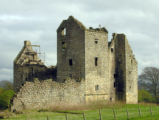
Torwood Castle is a ruined 16th-century L-plan castle near the village of Torwood, in the Falkirk Council area of central Scotland. It was designated as a Category A listed building in 1979. The Buildings at Risk Register for Scotland originally listed its level of risk as low, but raised that level to moderate in mid-2019 after seeing signs of continued neglect. History The estate was held originally by the Foresters of Garden, who were the foresters responsible for the nearby Royal Forest of Tor Wood from the second half of the 15th century until the mid-17th century. Based on the date found on a carved stone panel found not far from the castle in 1918, the castle has been estimated as being built around 1566 for Sir Alexander Forrester. It passed to Clan Baillie in the early 16th century and then to George, 1st Lord Forrester in 1635. The castle was captured prefatory to taking Stirling Castle during the 1585 successful rebellion of the Earls of Mar and Angus. The castle was ... [...More Info...] [...Related Items...] OR: [Wikipedia] [Google] [Baidu] |
Larbert
Larbert ( gd, Lèirbert/Leth-pheairt, sco, Lairbert) is a small town in the Falkirk council area of Scotland. The town lies in the Forth Valley above the River Carron which flows from the west. Larbert is from the shoreline of the Firth of Forth and northwest of Falkirk, the main town in the area. The village of Stenhousemuir lies directly east of Larbert, with both settlements being contiguous and sharing certain public amenities with one another. In medieval times, the Larbert area was heavily forested, but this was cleared and gave rise to much of the agricultural land which surrounds the town. The coming of industry and especially the arrival in the 1840s of the Scottish Central Railway, which passes through the village, provided a base for economic growth. From the late 18th century until the mid-20th century heavy industry, such as boilermaking, casting and manufacturing underpinned the economy of Larbert. The Victorian era also saw the opening of the Stir ... [...More Info...] [...Related Items...] OR: [Wikipedia] [Google] [Baidu] |
A9 Road (Great Britain)
The A9 is a major road in Scotland running from the Falkirk council area in central Scotland to Scrabster Harbour, Thurso in the far north, via Stirling, Bridge of Allan, Perth and Inverness. At 273 miles (439 km), it is the longest road in Scotland and the fifth-longest A-road in the United Kingdom. Historically it was the main road between Edinburgh and John o' Groats, and has been called ''the spine of Scotland''. It is one of the three major north–south trunk routes linking the Central Belt to the Highlands - the others being the A82 and the A90. The road's origins lie in the military roads building programme of the 18th century, further supplemented by the building of several bridges in later years. The A9 route was formally designated in 1923, and originally ran from Edinburgh to Inverness. The route was soon extended north from Inverness up to John O'Groats. By the 1970s the route was hampered by severe traffic congestion, and an extensive upgrading pro ... [...More Info...] [...Related Items...] OR: [Wikipedia] [Google] [Baidu] |
Dunipace
Dunipace is a village in the west of the Falkirk council area of Scotland. The village is south of Stirling and north-west of Falkirk. The village is situated on the north bank of the River Carron and adjoins the town of Denny, to the south of the river. Dunipace is part of the historic county of Stirlingshire. The main road through Dunipace is the A872 road between Denny and Stirling. Based on the 2001 census, Falkirk council reported the population of Dunipace as being 2,444 residents.No 3 - 2001 Census Population of settlements and wards www.falkirk.gov.uk. Retrieved 2011-05-08 History In 1983 a temporary Roman marching camp was found from aerial photographs just outside the t ...[...More Info...] [...Related Items...] OR: [Wikipedia] [Google] [Baidu] |
James Douglas, Lord Of Douglas
Sir James Douglas (also known as Good Sir James and the Black Douglas; – 1330) was a Scottish knight and feudal lord. He was one of the chief commanders during the Wars of Scottish Independence. Early life He was the eldest son of Sir William Douglas, known as "le Hardi" or "the bold", who had been the first noble supporter of William Wallace (the elder Douglas died circa 1298, a prisoner in the Tower of London). His mother was Elizabeth Stewart, the daughter of Alexander Stewart, 4th High Steward of Scotland, who died circa 1287 or early 1288. His father remarried in late 1288 so Douglas' birth had to be prior to that; however, the destruction of records in Scotland makes an exact date or even year impossible to pinpoint. Douglas was sent to France for safety in the early days of the Wars of Independence, and was educated in Paris. There he met William Lamberton, Bishop of St. Andrews, who took him as a squire. He returned to Scotland with Lamberton. His lands had been ... [...More Info...] [...Related Items...] OR: [Wikipedia] [Google] [Baidu] |
Battle Of Bannockburn
The Battle of Bannockburn ( gd, Blàr Allt nam Bànag or ) fought on June 23–24, 1314, was a victory of the army of King of Scots Robert the Bruce over the army of King Edward II of England in the First War of Scottish Independence. It was a major turning point in the war, which only officially ended 14 years later with the ''de jure'' restoration of Scottish independence under the Treaty of Edinburgh–Northampton; for this reason, Bannockburn is considered a landmark moment in Scottish history. King Edward II invaded Scotland after Bruce demanded in 1313 that all supporters, still loyal to ousted Scottish king John Balliol, acknowledge Bruce as their king or lose their lands. Stirling Castle, a Scots royal fortress occupied by the English, was under siege by the Scottish army. King Edward assembled a formidable force of soldiers to relieve it – the largest army ever to invade Scotland. The English summoned 25,000 infantry soldiers and 2,000 horses from England, Ireland a ... [...More Info...] [...Related Items...] OR: [Wikipedia] [Google] [Baidu] |
Camelon
Camelon (; sco, Caimlan, gd, Camlann) is a large settlement within the Falkirk council area, . The village is in the , west of , south of Larbert and east of [...More Info...] [...Related Items...] OR: [Wikipedia] [Google] [Baidu] |
Bannockburn
Bannockburn (Scottish Gaelic ''Allt a' Bhonnaich'') is an area immediately south of the centre of Stirling in Scotland. It is part of the City of Stirling. It is named after the Bannock Burn, a stream running through the town before flowing into the River Forth. History Land in the vicinity of Bannockburn town, probably between the Pelstream and Bannock burns (hence Bannockburn), was the site of the Battle of Bannockburn fought in 1314—one of the pivotal battles of the 13th/14th century Wars of Independence between the kingdoms of Scotland and England. A large monument and visitor centre is located near the site of the battle. In previous generations tourists came to visit the site and look at the Borestone. The dignity of the barony of Bannockburn is currently held by Hope Vere Anderson, a descendant of the Sandilands and Vere families of Sandilands and Lesmahagow, Lanarkshire who were the original Barons of Bannockburn in the 14th century. In the year of 1746, after the Ba ... [...More Info...] [...Related Items...] OR: [Wikipedia] [Google] [Baidu] |
Scotland
Scotland (, ) is a country that is part of the United Kingdom. Covering the northern third of the island of Great Britain, mainland Scotland has a border with England to the southeast and is otherwise surrounded by the Atlantic Ocean to the north and west, the North Sea to the northeast and east, and the Irish Sea to the south. It also contains more than 790 islands, principally in the archipelagos of the Hebrides and the Northern Isles. Most of the population, including the capital Edinburgh, is concentrated in the Central Belt—the plain between the Scottish Highlands and the Southern Uplands—in the Scottish Lowlands. Scotland is divided into 32 administrative subdivisions or local authorities, known as council areas. Glasgow City is the largest council area in terms of population, with Highland being the largest in terms of area. Limited self-governing power, covering matters such as education, social services and roads and transportation, is devolved from the ... [...More Info...] [...Related Items...] OR: [Wikipedia] [Google] [Baidu] |
United Kingdom Census 2011
A Census in the United Kingdom, census of the population of the United Kingdom is taken every ten years. The 2011 census was held in all countries of the UK on 27 March 2011. It was the first UK census which could be completed online via the Internet. The Office for National Statistics (ONS) is responsible for the census in England and Wales, the General Register Office for Scotland (GROS) is responsible for the census in Scotland, and the Northern Ireland Statistics and Research Agency (NISRA) is responsible for the census in Northern Ireland. The Office for National Statistics is the executive office of the UK Statistics Authority, a non-ministerial department formed in 2008 and which reports directly to Parliament. ONS is the UK Government's single largest statistical producer of independent statistics on the UK's economy and society, used to assist the planning and allocation of resources, policy-making and decision-making. ONS designs, manages and runs the census in England an ... [...More Info...] [...Related Items...] OR: [Wikipedia] [Google] [Baidu] |
Falkirk (council Area)
Falkirk (; sco, Fawkirk; gd, An Eaglais Bhreac) is one of 32 unitary authority council areas of Scotland. It was formed on 1 April 1996 by way of the Local Government etc. (Scotland) Act 1994 from the exact boundaries of Falkirk District, one of three parts of the Central region created in 1975, which was abolished at that time. Prior to the 1975 reorganisation, the majority of the council area was part of the historic county of Stirlingshire, and a small part, namely Bo'ness and Blackness, was part of the former county of West Lothian. The council area borders with North Lanarkshire, Stirling and West Lothian, and, across the Firth of Forth to the northeast, Clackmannanshire and Fife. The largest town, and the location of the council headquarters, is Falkirk; other settlements, most of which surround Falkirk within of its centre, include Bo'ness, Bonnybridge, Denny, Grangemouth, Larbert, Polmont, Shieldhill, Camelon and Stenhousemuir. The council is led by the SNP wh ... [...More Info...] [...Related Items...] OR: [Wikipedia] [Google] [Baidu] |


.jpg)
