|
Tel Aviv Metro
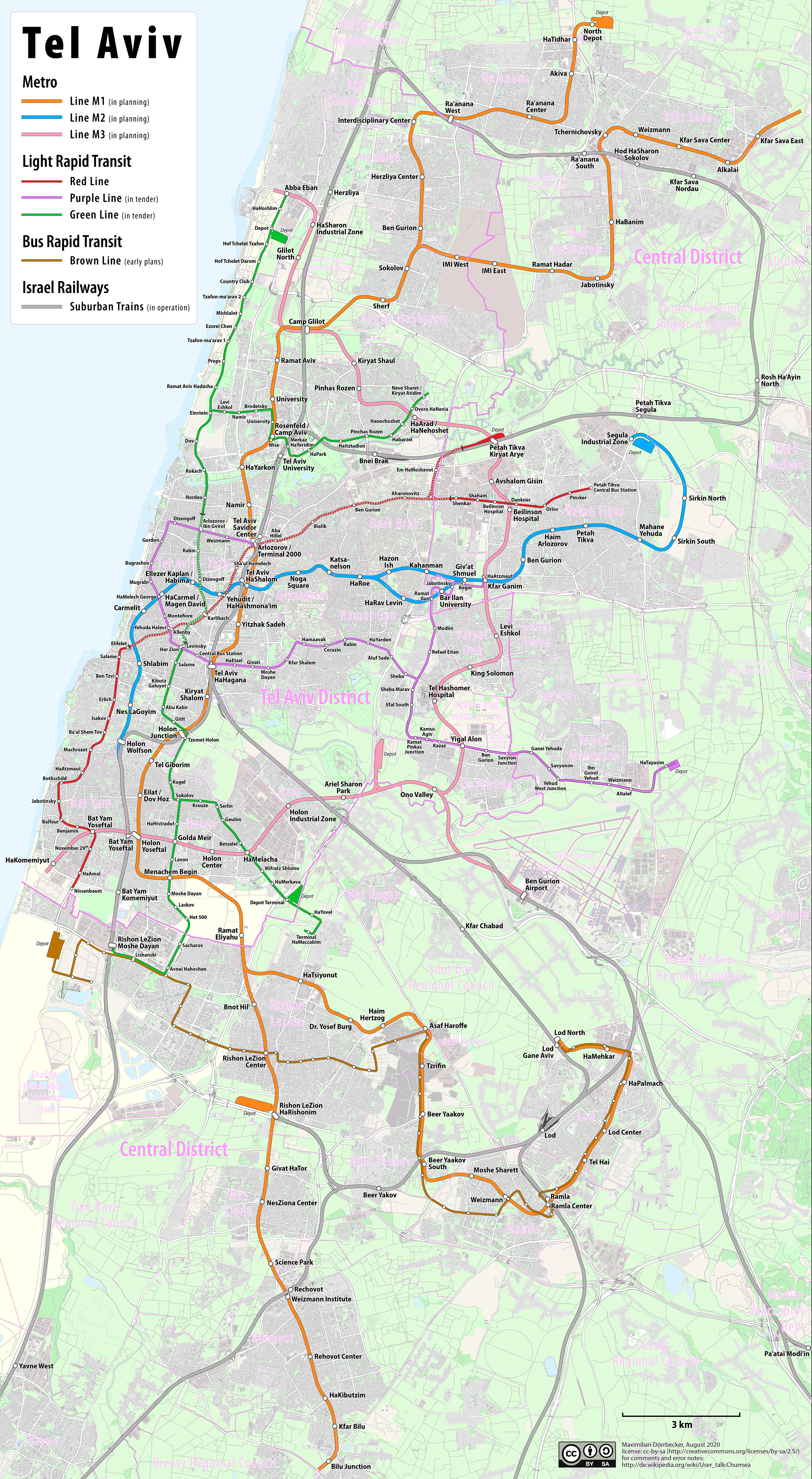
Tel Aviv Metro (also MetroTLV) is a planned subway system for the Tel Aviv Metropolitan Area. It will augment the Tel Aviv Light Rail and Israel Railways suburban lines and consist of three underground metro lines to form a rapid transit transportation solution for the city. Construction is expected to start in 2025, with the first public opening in 2032. The legal foundation for building the metro is found in National Outline Plan 70. History The plan for the metro was born in 2015 in the Israeli ministry of finance, bypassing the transportation ministry. The ministry's rationale was that the light rail plan would not be sufficient to answer Tel Aviv's transportation needs as early as the 2020s, when the first lines would be completed. Multiple alternatives were proposed in internal discussions. At the time, the plan was met with surprise at the transportation ministry. By early 2016 the two ministries agreed on a general outline that would include three of the seven planned ... [...More Info...] [...Related Items...] OR: [Wikipedia] [Google] [Baidu] |
Kiryat Shalom
, wiktionary:בית, :he:בית, house * * * * E , wiktionary:עין, spring (hydrology), spring, fountain * * , wiktionary:עמק, :he:עמק, valley * G , wiktionary:גן, :he:גן, "garden" * , wiktionary:גבעה, :he:גבעה, "hill" * * * H , wiktionary:הר, :he:הר, mountain * K , wiktionary:כרם, :he:כרם, vineyard * , wiktionary:כפר, :he:כפר, village * , wiktionary:קריה, town * * M , wiktionary:מעיין, :he:מעיין, spring (hydrology), spring, fountain * * , wiktionary:he:משמר, :he:משמר (פירושונים), guard * N , wiktionary:נחל, :he:נחל, stream, wadi, Biblical Hebrew: valley * * , in this context: (place of) residence, abode, oasis * R , wiktionary:רמה, "heights", "highlands" * , "heights", "highlands"; plural of wiktionary:רמה, רמה, feminine form of wiktionary:רם, רם * , wiktionary:ראש, "head" * T , wiktionary:תל, :he: ... [...More Info...] [...Related Items...] OR: [Wikipedia] [Google] [Baidu] |
Wolfson Medical Center
Wolfson Medical Center ( he, מרכז רפואי וולפסון) (transliteration: ''Merkaz Refui Wolfson'') is a hospital in the Tel Aviv District city of Holon, Israel. Wolfson Hospital is located in southern Tel Aviv Metropolitan Area in a vicinity abounded by a population of nearly half a million inhabitants. It ranks as the ninth largest hospital in Israel. The medical center was founded with the assistance of the Wolfson Foundation and named after Lady Edith Specterman Wolfson, Sir Isaac Wolfson's wife. History The medical center in Holon was opened to the public in 1980 on the southern Tel Aviv border. The center has grown since from 342 beds to over 650 beds in 2007 with an additional 30 outpatient beds. Services The Wolfson Medical Center departments are affiliated with the Sackler School of Medicine, Tel Aviv University and tutors students during their intern years. The center employs over 100 doctors that also hold posts, ranging from instructors to professors, a ... [...More Info...] [...Related Items...] OR: [Wikipedia] [Google] [Baidu] |
Ramla
Ramla or Ramle ( he, רַמְלָה, ''Ramlā''; ar, الرملة, ''ar-Ramleh'') is a city in the Central District of Israel. Today, Ramle is one of Israel's mixed cities, with both a significant Jewish and Arab populations. The city was founded in the early 8th century CE by the Umayyad prince Sulayman ibn Abd al-Malik as the capital of Jund Filastin, the district he governed in Bilad al-Sham before becoming caliph in 715. The city's strategic and economic value derived from its location at the intersection of the ''Via Maris'', connecting Cairo with Damascus, and the road connecting the Mediterranean port of Jaffa with Jerusalem. It rapidly overshadowed the adjacent city of Lydda, whose inhabitants were relocated to the new city. Not long after its establishment, Ramla developed as the commercial centre of Palestine, serving as a hub for pottery, dyeing, weaving, and olive oil, and as the home of numerous Muslim scholars. Its prosperity was lauded by geographers in the 10 ... [...More Info...] [...Related Items...] OR: [Wikipedia] [Google] [Baidu] |
Be'er Ya'akov
Be'er Ya'akov ( he, בְּאֵר יַעֲקֹב, ''lit.'' Jacob's Well) is a city in central Israel, near Ness Ziona and Rishon Lezion. The town has an area of 8,580 dunams (~8.6 km²), and had a population of 30,338 in 2022. History Be'er Ya'akov was established in 1907 on 2,000 dunams of land purchased by a company headed by Meir Dizengoff from a Lutheran German colony the previous year. It was divided into two sectors, one for immigrants from Russia, Poland, Romania, Bulgaria, Argentina, and Iran, and the other for Mountain Jews from Dagestan. It was named after Yaakov Yitzhaki, a rabbi and pioneer from the Mountain Jewish community. Yitzhaki headed the Mountain Jewish pioneers who settled there. In 1909, there were 25 families living in Be'er Ya'akov, and tensions between the Ashkenazi and Dagestani families. In 1910, the first elementary school was established. According to a census conducted in 1922 by the British Mandate authorities, Be'er Ya'akov had 131 inhabitant ... [...More Info...] [...Related Items...] OR: [Wikipedia] [Google] [Baidu] |
Tzrifin
Tzrifin ( he, צְרִיפִין) is an area in Gush Dan (Dan Region) in central Israel, located on the eastern side of Rishon LeZion and including parts of Be'er Ya'akov. The area proper is defined as an 'area without jurisdiction' between the two cities. Nearly the entire area of Tzrifin proper was taken up by the central Israel Defense Forces (IDF) base, Camp Yigael Yadin (a.k.a. Camp Tzrifin, Camp 782), with which it is synonymous, even though the base also spills into Rishon LeZion and Be'er Ya'akov. Camp Yadin contains a multitude of training bases, as well as Prison Four, the largest Israeli military prison. In late 2010s it was decided to vacate the area, move its bases to Camp Ariel Sharon and repurpose the land for residential development. History During the 18th and 19th centuries, the area of Tzrifin belonged to the Nahiyeh (sub-district) of Lod that encompassed the area of the present-day city of Modi'in-Maccabim-Re'ut in the south to the present-day city of El'a ... [...More Info...] [...Related Items...] OR: [Wikipedia] [Google] [Baidu] |
Ramat HaHayal
Ramat HaHayal ( he, רמת החייל, ''lit.'' Soldiers Hill) is a northeastern neighborhood of Tel Aviv, Israel. Some high tech firms have research and development offices in Ramat HaHayal. History The neighborhood was established in 1949 to absorb demobilized soldiers after the 1948 Arab–Israeli War. In 1954, Tel Aviv municipality donated a plot of land on Golan Street in Ramat HaHayal, dubbed "Shikun Shanghai", to members of the Jewish community from Shanghai, China, who left during the final stages of the Chinese Civil War. Until 2010, it was widely assumed that the neighborhood had been named after the Jewish Brigade and its name was written in Hebrew (''lit.'' Jewish Brigade Heights), including in official municipal signs. The mistake was corrected by the municipality in 2010. Many Israeli high-tech companies, among them Nisko, RAD Data Communications, BMC Software, Comverse Technology and Radwin are located in Ramat HaHayal. IBM maintains a research and development ... [...More Info...] [...Related Items...] OR: [Wikipedia] [Google] [Baidu] |
Kiryat Atidim
Kiryat Atidim () is a high tech district of Tel Aviv, Israel. History Kiryat Atidim is located in North East of Tel Aviv near the Petah Tikva industrial zone. The zone was opened in 1972 as a project of Tel Aviv University and Tel Aviv City Hall Tel Aviv City Hall ( he, בית עיריית תל אביב ''Beit Iriyat Tel Aviv'') is the municipal government center of Tel Aviv, Israel. It houses the mayor's office, the meeting chambers and offices of the Tel Aviv City Council. History .... Tel Aviv City Hall, led at the time by Yehoshua Rabinovich, provided the founding company, Atidim, with , to build the district. References External links Kiryat Atidim website {{Neighborhoods of Tel Aviv Neighborhoods of Tel Aviv Science parks in Israel High-technology business districts in Israel ... [...More Info...] [...Related Items...] OR: [Wikipedia] [Google] [Baidu] |
Israel Weapons Industries
Israel Weapon Industries (IWI), formerly the Magen division of the Israel Military Industries Ltd. (IMI), is an Israeli firearms manufacturer. It was founded in 1933. Formerly owned by the State of Israel, the Small Arms Division of IMI was privatized and renamed IWI in 2005. IWI is one of the world's most famous and bestselling military arms manufacturers. The Magen division rose to international prominence in the 1950s, as the creator of the Uzi, of which over 10 million would be produced, netting billions of dollars for the company. Subsequent well known military exports have included the Jericho 941 semi-automatic pistol, Negev light machine gun, Galil assault rifle, Tavor assault rifle, and the DAN .338 sniper rifle. IWI develops and manufactures guns used by armies and law enforcement agencies around the world. Manufacturing Ramat HaSharon For many decades, IWI and the Magen division of Israeli Military Industries before it, has manufactured its weapons in Ra ... [...More Info...] [...Related Items...] OR: [Wikipedia] [Google] [Baidu] |
Hod HaSharon
Hod HaSharon ( he, הוֹד הַשָּׁרוֹן, lit. "Splendor of the Sharon, Israel, Sharon plain") is a city in the Central District (Israel), Central District of Israel. The city is located approximately east of the Mediterranean coastline, south of Kfar Saba, southeast of Raanana, and northeast of Ramat HaSharon. Hod HaSharon was officially formed and made a local council (Israel), local council in 1964 by the merging of four ''moshavot'': Magdiel, Ramatayim, Hadar, Hod HaSharon, Hadar, and Ramat Hadar.''Encyclopedia Judaica'', Keter Publishing House, Jerusalem, 1972, Vol. 8, p. 802, "Hod Ha-Sharon" The land area of Hod HaSharon is , and according to the Israel Central Bureau of Statistics (CBS), in the city had a total population of . History Before the 20th century, 20th century, the area of Hod HaSharon formed part of the Forest of Sharon, a hallmark of the region’s historical landscape. It was an open woodland dominated by Mount Tabor Oak Quercus ithaburensis, (Que ... [...More Info...] [...Related Items...] OR: [Wikipedia] [Google] [Baidu] |
Kfar Sava
Kfar Saba ( he, כְּפַר סָבָא), officially Kefar Sava, is a city in the Sharon region, of the Central District of Israel. In 2019 it had a population of 110,456, making it the 16th-largest city in Israel. The population of Kfar Saba is nearly entirely Jewish. History of modern Kfar Saba The Palestinian village of Kafr Saba was considered to be ancient Capharsaba – an important settlement during the Second Temple period in ancient Judea,The Origin of the Name Capharsaba Kfar Sava Municipal Council is mentioned for the first time in the writings of , in his account of the attempt of |
Rehovot
Rehovot ( he, רְחוֹבוֹת ''Rəḥōvōt'', ar, رحوڤوت ''Reḥūfūt'') is a city in the Central District of Israel, about south of Tel Aviv. In it had a population of . Etymology Israel Belkind, founder of the Bilu movement, proposed the name "Rehovot" (lit. 'wide expanses') based on Genesis 26:22: "And he called the name of it ''Rehoboth''; and he said: 'For now the Lord hath made room for us, and we shall be fruitful in the land'." This Bible verse is also inscribed in the city's logo. The biblical town of '' Rehoboth'' was located in the Negev Desert. History Ottoman era Rehovot was established in 1890 by pioneers of the First Aliyah on the coastal plain near a site called ''Khirbat Deiran'', an "abandoned or sparsely populated" estate, which now lies in the center of the built-up area of the city. According to Marom, Deiran offered "a convenient launching pad for early land purchase initiatives which shaped the pattern of Jewish settlement until the b ... [...More Info...] [...Related Items...] OR: [Wikipedia] [Google] [Baidu] |


_camp.jpg)


