|
Sar-e-Sang
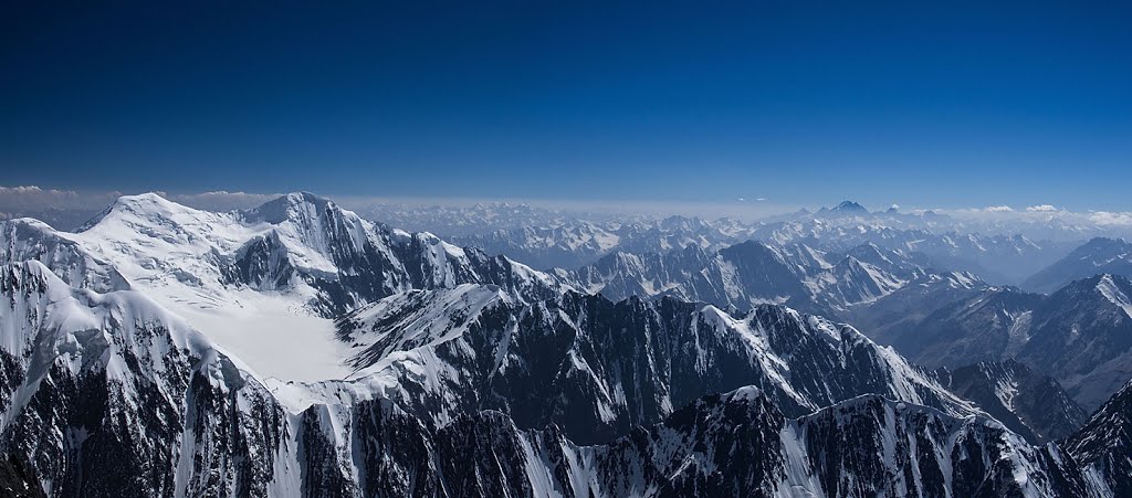
Sar-i Sang (or Sar-e Sang) (lit. "stone summit" in Persian) is a settlement in the Kuran Wa Munjan District of Badakhshan Province, Afghanistan, famous for its ancient lapis lazuli mines producing the world's finest lapis. It is located in the Koksha Valley. Lapis lazuli mines The Sar-i Sang lapis lazuli mine probably dates from proto-historic times. It consists of one old disused shaft and two new shafts. This was the main source of lapis lazuli in the ancient world, with lapis from here occurring in such famous archaeological discoveries as the Royal Treasure of Ur and the Tomb of Tutankhamun.Warwick Ball, 2008, 'The Monuments of Afghanistan: History, Archaeology and Architecture': 261, London. See also * Mount Imeon References * Warwick Ball, 2008, 'The Monuments of Afghanistan: History, Archaeology and Architecture': 261, I.B. TAURIS, London, . * Warwick Ball, 1982, 'Archaeological Gazetteer of Afghanistan': Volume I: 1001. SAR-I SANG, Editions Recherche sur les civi ... [...More Info...] [...Related Items...] OR: [Wikipedia] [Google] [Baidu] |
Lazurite
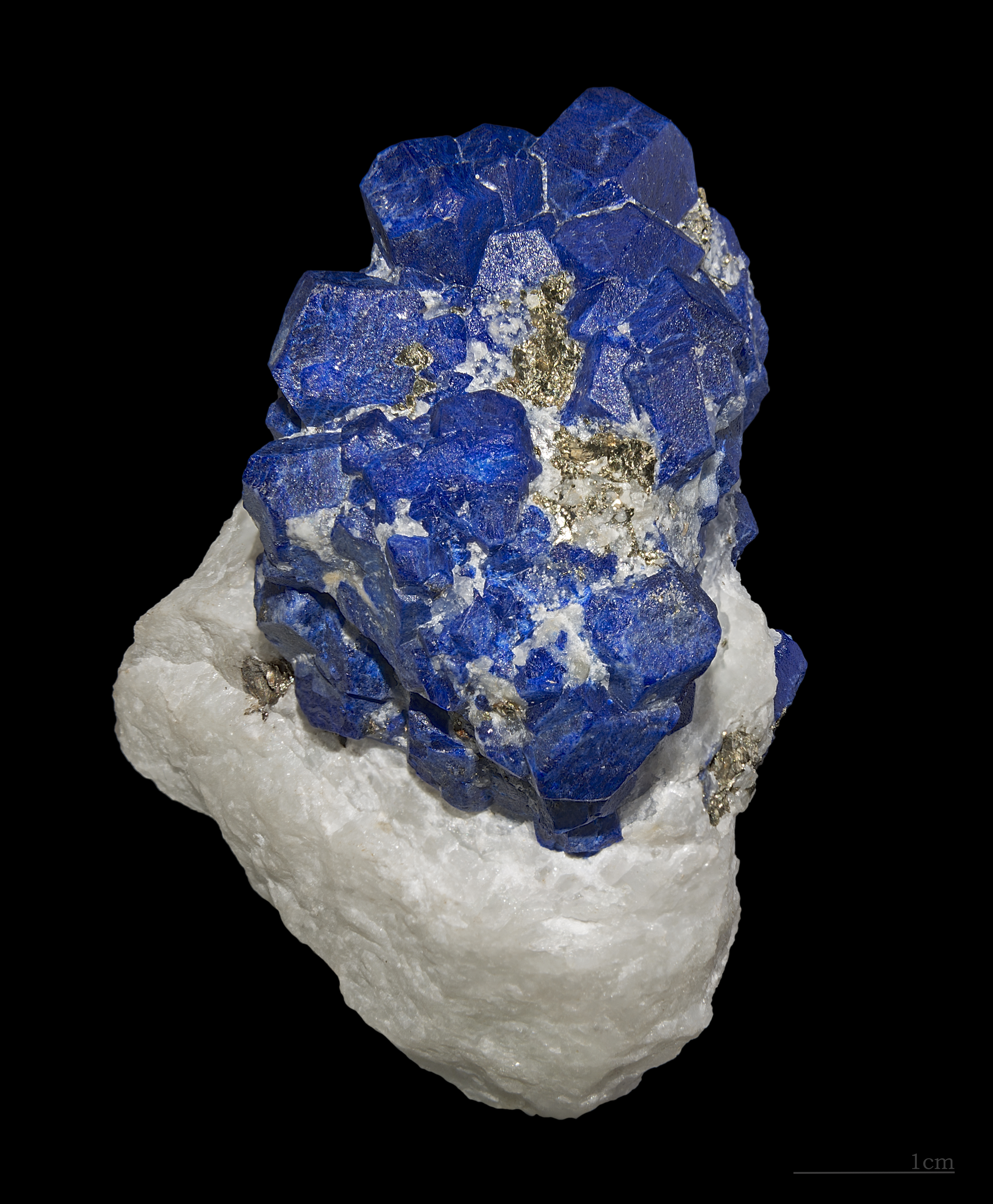
Lazurite is a tectosilicate mineral with sulfate, sulfur and chloride with formula . It is a feldspathoid and a member of the sodalite group. Lazurite crystallizes in the isometric system although well‐formed crystals are rare. It is usually massive and forms the bulk of the gemstone lapis lazuli. Lazurite is a deep‐blue to greenish‐blue. The colour is due to the presence of anions. It has a Mohs hardness of 5.0 to 5.5 and a specific gravity of 2.4. It is translucent with a refractive index of 1.50. It is fusible at 3.5 on Wolfgang Franz von Kobell's fusibility scale, and soluble in HCl. It commonly contains or is associated with grains of pyrite. Lazurite is a product of contact metamorphism of limestone and is typically associated with calcite, pyrite, diopside, humite, forsterite, hauyne and muscovite. Other blue minerals, such as the carbonate azurite and the phosphate lazulite, may be confused with lazurite, but are easily distinguished with careful examination. A ... [...More Info...] [...Related Items...] OR: [Wikipedia] [Google] [Baidu] |
Badakhshan Province
Badakhshan Province (Persian/ Uzbek: , ''Badaxšān'') is one of the 34 provinces of Afghanistan, located in the northeastern part of the country. It is bordered by Tajikistan's Gorno-Badakhshan in the north and the Pakistani regions of Lower and Upper Chitral and Gilgit-Baltistan in the southeast. It also has a 91-kilometer (57-mile) border with China in the east. It is part of a broader historical Badakhshan region, parts of which now also lie in Tajikistan and China. The province contains 22 districts, over 1,200 villages and approximately 1 055 00people. Fayzabad, Badakhshan, Fayzabad serves as the provincial capital. Resistance activity has been reported in the province since the 2021 Taliban takeover of Afghanistan. Etymology Badakhshan's name comes from the Middle Persian word "badaxš", which is an official title. The word "ān" is a suffix which demonstrates a place's name; therefore the word "badaxšān" means a place belonging to a person called "badaxš". Duri ... [...More Info...] [...Related Items...] OR: [Wikipedia] [Google] [Baidu] |
Lapis Lazuli
Lapis lazuli (; ), or lapis for short, is a deep-blue metamorphic rock used as a semi-precious stone that has been prized since antiquity for its intense color. As early as the 7th millennium BC, lapis lazuli was mined in the Sar-i Sang mines,David Bomford and Ashok Roy, ''A Closer Look- Colour'' (2009), National Gallery Company, London, () in Shortugai, and in other mines in Badakhshan province in northeast Afghanistan. Lapis lazuli artifacts, dated to 7570 BC, have been found at Bhirrana, which is the oldest site of Indus Valley civilisation. Lapis was highly valued by the Indus Valley Civilisation (7570–1900 BC). Lapis beads have been found at Neolithic burials in Mehrgarh, the Caucasus, and as far away as Mauritania. It was used in the funeral mask of Tutankhamun (1341–1323 BC). By the end of the Middle Ages, lapis lazuli began to be exported to Europe, where it was ground into powder and made into ultramarine, the finest and most expensive of all blue pigments. Ultra ... [...More Info...] [...Related Items...] OR: [Wikipedia] [Google] [Baidu] |
Koksha Valley
Koksha ( prs, , mnj, , ps, کوکشه) is a valley that is located in Badakhshan's Kuran Wa Munjan District in Afghanistan. Koksha is famous for its lapis lazuli found in the mines of Sar-e-Sang since the 3rd millennium BC. Koksha Valley includes Mount Ladjuar. The main river is the Koksha River The Kokcha River ( fa, رودخانه کوکچه) is located in northeastern Afghanistan. A tributary of the Panj river, it flows through Badakhshan Province in the Hindu Kush. It is named after the Koksha Valley. The city of Feyzabad lies alo ..., the tributary in the valley. Parts of the valley are also found in Jurm District. References {{improve categories, date=September 2022 Badakhshan Province Valleys of Afghanistan Mines ... [...More Info...] [...Related Items...] OR: [Wikipedia] [Google] [Baidu] |
Mount Imeon
Mount Imeon () is an ancient name for the Central Asian complex of mountain ranges comprising the present Hindu Kush, Pamir and Tian Shan, extending from the Zagros Mountains in the southwest to the Altay Mountains in the northeast, and linked to the Kunlun, Karakoram and Himalayas to the southeast. The term was used by Hellenistic-era scholars as "Imaus Mount", even though non-Greek in etymology, and predating Alexander the Great. Geography A detailed description of the mountainous territory and its people was given in the Armenian geography index '' Ashharatsuyts'' written by Anania Shirakatsi in the 7th century AD.Eremian, SurenReconstructed map of Central Asia from ‘Ashharatsuyts’./ref>Shirakatsi, Anania, ''The Geography of Ananias of Sirak (Asxarhacoyc): The Long and the Short Recensions''. Introduction, Translation and Commentary by Robert H. Hewsen. Wiesbaden: Reichert Verlag, 1992. 467 pp. According to the original ''Ashharatsuyts'' mapping reconstructed by Acad. ... [...More Info...] [...Related Items...] OR: [Wikipedia] [Google] [Baidu] |
Provinces Of Afghanistan
Afghanistan is divided into 34 provinces (, '' wilåyat''). The provinces of Afghanistan are the primary administrative divisions. Each province encompasses a number of districts or usually over 1,000 villages. Provincial governors played a critical role in the reconstruction of the Afghan state following the creation of the new government under Hamid Karzai. According to international security scholar Dipali Mukhopadhyay, many of the provincial governors of the western-backed government were former warlords who were incorporated into the political system. Provinces of Afghanistan Regions of Afghanistan UN Regions Former provinces of Afghanistan During Afghanistan's history it had a number of provinces in it. It started out as just Kabul, Herat, Qandahar, and Balkh but the number of provinces increased and by 1880 the provinces consisted of Balkh, Herat, Qandahar, Ghazni, Jalalabad, and Kabul. * Southern Province – dissolved in 1964 to create Paktia Provinc ... [...More Info...] [...Related Items...] OR: [Wikipedia] [Google] [Baidu] |
Kuran Wa Munjan District
Kuran wa Munjan District is one of the 28 districts of Badakhshan Province in eastern Afghanistan. Located in the Hindu Kush mountains, the district is home to approximately 8,000 residents. The district administrative center is Kuran wa Munjan. The district is in the southwest corner of the province, and is bordered on its northeast side by the Jurm and Zebak Districts. Most of the district's boundaries are adjacent to other Afghan provinces, but a very small section on the eastern edge of the district lies on the international border between Afghanistan and Pakistan. The epicenter of the October 26 2015 Hindu Kush earthquake was 45 km north of here. Famous valleys include the Koksha Valley Koksha ( prs, , mnj, , ps, کوکشه) is a valley that is located in Badakhshan's Kuran Wa Munjan District in Afghanistan. Koksha is famous for its lapis lazuli found in the mines of Sar-e-Sang since the 3rd millennium BC. Koksha Valley i ..., which is famous for its mi ... [...More Info...] [...Related Items...] OR: [Wikipedia] [Google] [Baidu] |
Afghanistan
Afghanistan, officially the Islamic Emirate of Afghanistan,; prs, امارت اسلامی افغانستان is a landlocked country located at the crossroads of Central Asia and South Asia. Referred to as the Heart of Asia, it is bordered by Pakistan to the Durand Line, east and south, Iran to the Afghanistan–Iran border, west, Turkmenistan to the Afghanistan–Turkmenistan border, northwest, Uzbekistan to the Afghanistan–Uzbekistan border, north, Tajikistan to the Afghanistan–Tajikistan border, northeast, and China to the Afghanistan–China border, northeast and east. Occupying of land, the country is predominantly mountainous with plains Afghan Turkestan, in the north and Sistan Basin, the southwest, which are separated by the Hindu Kush mountain range. , Demographics of Afghanistan, its population is 40.2 million (officially estimated to be 32.9 million), composed mostly of ethnic Pashtuns, Tajiks, Hazaras, and Uzbeks. Kabul is the country's largest city and ser ... [...More Info...] [...Related Items...] OR: [Wikipedia] [Google] [Baidu] |
National Geospatial Intelligence Agency
The National Geospatial-Intelligence Agency (NGA) is a combat support agency within the United States Department of Defense whose primary mission is collecting, analyzing, and distributing geospatial intelligence (GEOINT) in support of national security. Initially known as the National Imagery and Mapping Agency (NIMA) from 1996 to 2003, it is a member of the United States Intelligence Community. NGA headquarters, also known as NGA Campus East or NCE, is located at Fort Belvoir North Area in Springfield, Virginia. The agency also operates major facilities in the St. Louis, Missouri area (referred to as NGA Campus West or NCW), as well as support and liaison offices worldwide. The NGA headquarters, at , is the third-largest government building in the Washington metropolitan area after The Pentagon and the Ronald Reagan Building. In addition to using GEOINT for U.S. military and intelligence efforts, NGA provides assistance during natural and man-made disasters, aids in security ... [...More Info...] [...Related Items...] OR: [Wikipedia] [Google] [Baidu] |
Prehistoric
Prehistory, also known as pre-literary history, is the period of human history between the use of the first stone tools by hominins 3.3 million years ago and the beginning of recorded history with the invention of writing systems. The use of symbols, marks, and images appears very early among humans, but the earliest known writing systems appeared 5000 years ago. It took thousands of years for writing systems to be widely adopted, with writing spreading to almost all cultures by the 19th century. The end of prehistory therefore came at very different times in different places, and the term is less often used in discussing societies where prehistory ended relatively recently. In the early Bronze Age, Sumer in Mesopotamia, the Indus Valley Civilisation, and ancient Egypt were the first civilizations to develop their own scripts and to keep historical records, with their neighbors following. Most other civilizations reached the end of prehistory during the following Iron Age. T ... [...More Info...] [...Related Items...] OR: [Wikipedia] [Google] [Baidu] |
Tutankhamun
Tutankhamun (, egy, twt-ꜥnḫ-jmn), Egyptological pronunciation Tutankhamen () (), sometimes referred to as King Tut, was an Egyptian pharaoh who was the last of his royal family to rule during the end of the Eighteenth Dynasty (ruled in the conventional chronology) during the New Kingdom of Egyptian history. His father is believed to be the pharaoh Akhenaten, identified as the mummy found in the tomb KV55. His mother is his father's sister, identified through DNA testing as an unknown mummy referred to as "The Younger Lady" who was found in KV35. Tutankhamun took the throne at eight or nine years of age under the unprecedented viziership of his eventual successor, Ay, to whom he may have been related. He married his paternal half-sister Ankhesenamun. During their marriage they lost two daughters, one at 5–6 months of pregnancy and the other shortly after birth at full-term. His names—''Tutankhaten'' and ''Tutankhamun''—are thought to mean "Living image of At ... [...More Info...] [...Related Items...] OR: [Wikipedia] [Google] [Baidu] |


