|
Swefling
Sweffling is a village and a civil parish in the East Suffolk district, in the county of Suffolk, England. Nearby settlements include the town of Saxmundham and the village of Rendham. In 2011 the parish had a population of 187. From 1974 to 2019 it was in Suffolk Coastal Suffolk Coastal was a Non-metropolitan district, local government district in Suffolk, England. Its council was based in Melton, Suffolk, Melton, having moved from neighbouring Woodbridge, Suffolk, Woodbridge in 2017. Other towns include Fel ... district. The medieval church of St Mary the Virgin, restored in 1832, is a grade II* listed building. References Villages in Suffolk Civil parishes in Suffolk Suffolk Coastal Plomesgate Hundred {{Suffolk-geo-stub ... [...More Info...] [...Related Items...] OR: [Wikipedia] [Google] [Baidu] |
Suffolk Coastal
Suffolk Coastal was a Non-metropolitan district, local government district in Suffolk, England. Its council was based in Melton, Suffolk, Melton, having moved from neighbouring Woodbridge, Suffolk, Woodbridge in 2017. Other towns include Felixstowe, Framlingham, Leiston, Aldeburgh, and Saxmundham. The district was formed on 1 April 1974, under the Local Government Act 1972, as a merger of the municipal borough of Aldeburgh, along with Felixstowe, Leiston-cum-Sizewell, Saxmundham and Woodbridge, Suffolk, Woodbridge Urban district (Great Britain and Ireland), urban districts, and Blyth Rural District and Deben Rural District. The population of the district was 124,298 at the 2011 Census. Suffolk Coastal district was merged with Waveney District, Waveney district on 1 April 2019 to form the new East Suffolk (district), East Suffolk district. Election results There were new ward boundaries in 2003 and 2015. Wards represented Below is a list of wards with the number of counci ... [...More Info...] [...Related Items...] OR: [Wikipedia] [Google] [Baidu] |
Saxmundham
Saxmundham ( ) is a market town and civil parish in the East Suffolk district, in the county of Suffolk, England. It is set in the valley of the River Fromus about north-east of Ipswich and west of the coast at Sizewell. The town is bypassed by the main A12 road between London and Lowestoft. The town is served by Saxmundham railway station on the East Suffolk Line between Ipswich and Lowestoft. In 2011 the parish had a population of 3644. Governance The district electoral ward also has the name Saxmundham. Its population at the 2011 census was 4,913. Saxmundham Town Council consisted of eleven councillors. The Town Clerk is Mrs Sharon Smith. In 1894 Saxmundham became part of Plomesgate Rural District, in 1900 Saxmundham became an urban district, the district contained the parish of Saxmundham. On 1 April 1974 the district and parish were abolished and became part of Suffolk Coastal district in the non-metropolitan county of Suffolk. A successor parish was formed co ... [...More Info...] [...Related Items...] OR: [Wikipedia] [Google] [Baidu] |
Suffolk
Suffolk ( ) is a ceremonial county in the East of England and East Anglia. It is bordered by Norfolk to the north, the North Sea to the east, Essex to the south, and Cambridgeshire to the west. Ipswich is the largest settlement and the county town. The county has an area of and a population of 758,556. After Ipswich (144,957) in the south, the largest towns are Lowestoft (73,800) in the north-east and Bury St Edmunds (40,664) in the west. Suffolk contains five Non-metropolitan district, local government districts, which are part of a two-tier non-metropolitan county administered by Suffolk County Council. The Suffolk coastline, which includes parts of the Suffolk & Essex Coast & Heaths National Landscape, is a complex habitat, formed by London Clay and Crag Group, crag underlain by chalk and therefore susceptible to erosion. It contains several deep Estuary, estuaries, including those of the rivers River Blyth, Suffolk, Blyth, River Deben, Deben, River Orwell, Orwell, River S ... [...More Info...] [...Related Items...] OR: [Wikipedia] [Google] [Baidu] |
East Suffolk (district)
East Suffolk is a Non-metropolitan district, local government district in Suffolk, England. The largest town is Lowestoft, which contains Ness Point, the easternmost point of the United Kingdom. The second largest town is Felixstowe, which has the country's largest Port of Felixstowe, container port. On the district's south-western edge it includes parts of the Ipswich built-up area. The rest of the district is largely rural, containing many towns and villages, including several seaside resorts. Its council is based in the village of Melton, Suffolk, Melton. The district was formed in 2019 as a merger of the two previous districts of Suffolk Coastal and Waveney District, Waveney. In 2021 it had a population of 246,058. It is the most populous district in the country not to be a Unitary authorities of England, unitary authority. The district is on the coast, facing the North Sea. Much of the coast and adjoining areas lies within the Suffolk Coast and Heaths, a designated Area of O ... [...More Info...] [...Related Items...] OR: [Wikipedia] [Google] [Baidu] |
Central Suffolk And North Ipswich (UK Parliament Constituency)
Central Suffolk and North Ipswich is a constituency represented in the House of Commons of the UK Parliament since 2024 by Patrick Spencer of the Conservative Party, currently suspended and sitting as an Independent. Constituency profile Central Suffolk and North Ipswich is considered a safe seat for the Conservative Party at the parliamentary level, primarily made up of rural farming communities and retirement properties. At the local government level, the Ipswich wards are generally divided between the Conservatives and Labour, whilst the rural wards were previously dominated by the Conservatives but have seen large-scale gains by the Green Party in the 2020s. History The county constituency was formed for the 1997 general election, largely from eastern parts of the abolished constituency of Central Suffolk, including the north-western wards of the Borough of Ipswich. It also included western fringes of Suffolk Coastal. Sir Michael Lord, knighted in 2001, who had held ... [...More Info...] [...Related Items...] OR: [Wikipedia] [Google] [Baidu] |
Village Sign
In many parts of England, an ornamental village sign is erected to announce the village name to those entering the village. They are typically placed on the principal road entrance or in a prominent location such as a village green. The design often depicts a particularly characteristic feature of the village or a scene from its history, heritage, or culture. They are typically made of wood or metal or a combination of both, the designs are often made by the local community. Ornamental timber and iron signs were common historically to identify buildings of importance such as inns or town halls. However, the tradition of village signs is believed to have started in Norfolk early in the 20th century when Edward VII suggested that village signs would aid motorists and give a feature of interest on the Sandringham Estate. The spread of interest beyond Norfolk can be attributed to Prince Albert, Duke of York (later George VI) who gave a speech to the Royal Academy in 1920 promot ... [...More Info...] [...Related Items...] OR: [Wikipedia] [Google] [Baidu] |
Rendham
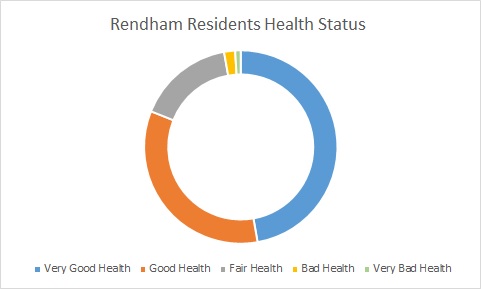
Rendham is a village and civil parish on the B1119 road, in the East Suffolk district, in the English county of Suffolk. It is near the town Saxmundham and the village Sweffling. Etymology Rendham comes from Old English and Saxon. Rend is the Old English "rymed" meaning cleared. "Ham" is Saxon, meaning village. Rendham therefore means cleared village, taken from that the village being placed in a clearing by the River Alde, surrounded by woodland. Geography Rendham lies on the River Alde, near its confluence with The Gull which diverts to Sweffling downstream from Rendham. The surrounding area is rural, farmland dotted with small areas of woodland. Rendham has two village greens called Rendham Green and The Knoll which are owned by the local Parish. Between 1870 and 1872, Rendham's location was described in John Marius Wilson's ''Imperial Gazetteer of England and Wales'': Rendham has a healthy populace, the majority of the population (175 people) in 2011 having very good ... [...More Info...] [...Related Items...] OR: [Wikipedia] [Google] [Baidu] |
Villages In Suffolk
A village is a human settlement or community, larger than a hamlet but smaller than a town with a population typically ranging from a few hundred to a few thousand. Although villages are often located in rural areas, the term urban village is also applied to certain urban neighborhoods. Villages are normally permanent, with fixed dwellings; however, transient villages can occur. Further, the dwellings of a village are fairly close to one another, not scattered broadly over the landscape, as a dispersed settlement. In the past, villages were a usual form of community for societies that practice subsistence agriculture and also for some non-agricultural societies. In Great Britain, a hamlet earned the right to be called a village when it built a church.Dr Greg Stevenson, "Wha ... [...More Info...] [...Related Items...] OR: [Wikipedia] [Google] [Baidu] |
Civil Parishes In Suffolk
Civil may refer to: *Civility, orderly behavior and politeness *Civic virtue, the cultivation of habits important for the success of a society *Civil (journalism) ''The Colorado Sun'' is an online news outlet based in Denver, Colorado. It launched on September 10, 2018, to provide long-form, in-depth coverage of news from all around Colorado. It was started with two years of funding from blockchain ventu ..., a platform for independent journalism * Civil (surname) See also * {{Disambiguation ... [...More Info...] [...Related Items...] OR: [Wikipedia] [Google] [Baidu] |


