|
Spotland
Spotland ( ) is a district of Rochdale in Greater Manchester, England. The Rochdale ward name is Spotland and Falinge. The population of this ward at the 2011 census was 10,805. It lies on the River Spodden, and is the home of Spotland Stadium. Historically a part of Lancashire, Spotland was formerly its own township within the ancient parish of Rochdale. The name Spotland means "area around the Spodden", Spodden referring to the River Spodden, which itself means "spouting stream". Spotland Primary School A primary school (in Ireland, the United Kingdom, Australia, Trinidad and Tobago, Jamaica, and South Africa), junior school (in Australia), elementary school or grade school (in North America and the Philippines) is a school for primary e ... lies within the locality on Edmund Street. References Areas of Rochdale {{GreaterManchester-geo-stub pl:Spotland Stadium ... [...More Info...] [...Related Items...] OR: [Wikipedia] [Google] [Baidu] |
Spotland Stadium
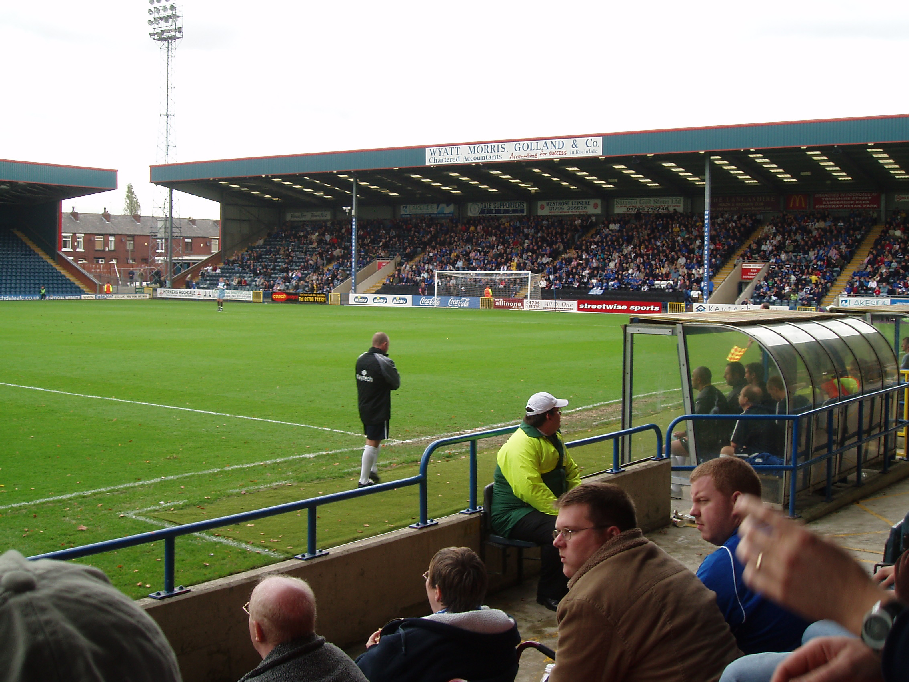
Spotland Stadium, known as the Crown Oil Arena for sponsorship reasons, in the Spotland area of Rochdale, Greater Manchester, is home to Rochdale A.F.C. and Rochdale Hornets R.F.L.C. and has a capacity of 10,249. History Spotland was originally known as St Clement's Playing Fields, after the nearby St Clement's Church. Having previously been used for cricket, it became the home of St Clement's Rugby Club in 1878, until they disbanded in 1897. As well as staging local rugby competitions, the ground briefly hosted two short-lived football clubs – the original Rochdale A.F.C. from 1900 to 1901 and Rochdale Town from 1902 to 1903, but both folded. The present Rochdale A.F.C. was then formed to use the ground in 1907, later buying the freehold for £1,700 in 1914. By the time the club joined the Football League in 1921, a low wooden grandstand had been built on the south side of the ground, once the location of the cricket pavilion. Also by this time, the name of the surroundin ... [...More Info...] [...Related Items...] OR: [Wikipedia] [Google] [Baidu] |
River Spodden
The River Spodden is a watercourse in North West England, one of two major tributaries of the River Roch. It rises in the Lancashire South Pennine hills north of Whitworth and flows south through what is now known as the Whitworth Valley to Rochdale, Greater Manchester, where the river merges with the River Roch. Nestled within the picturesque wooded valley is Healey Dell Nature Reserve. Source and course The river rises at Freeholds Top, on Shawforth Moor, north-east of Shawforth village, Whitworth, east of Britannia, out of Bacup and south-west of Inchfield Moor. In the early 19th century, the source was listed as "near High House". It flows south through its narrow valley through Shawforth, Facit, Whitworth and Broadley, and for about a kilometre it forms the boundary between both Rochdale and Rossendale districts and Greater Manchester and Lancashire counties. It then flows through Healey Dell, Lowerfold, Shawclough, Spotland Fold and Spotland Bridge to join the Roch at M ... [...More Info...] [...Related Items...] OR: [Wikipedia] [Google] [Baidu] |
Rochdale
Rochdale ( ) is a large town in Greater Manchester, England, at the foothills of the South Pennines in the dale on the River Roch, northwest of Oldham and northeast of Manchester. It is the administrative centre of the Metropolitan Borough of Rochdale, which had a population of 211,699 in the 2011 census. Located within the historic boundaries of the county of Lancashire. Rochdale's recorded history begins with an entry in the Domesday Book of 1086 under "Recedham Manor". The ancient parish of Rochdale was a division of the hundred of Salford and one of the largest ecclesiastical parishes in England, comprising several townships. By 1251, Rochdale had become important enough to have been granted a Royal charter. Rochdale flourished into a centre of northern England's woollen trade, and by the early 18th century was described as being "remarkable for many wealthy merchants". Rochdale rose to prominence in the 19th century as a mill town and centre for textile manufacture ... [...More Info...] [...Related Items...] OR: [Wikipedia] [Google] [Baidu] |
Rochdale (ancient Parish)
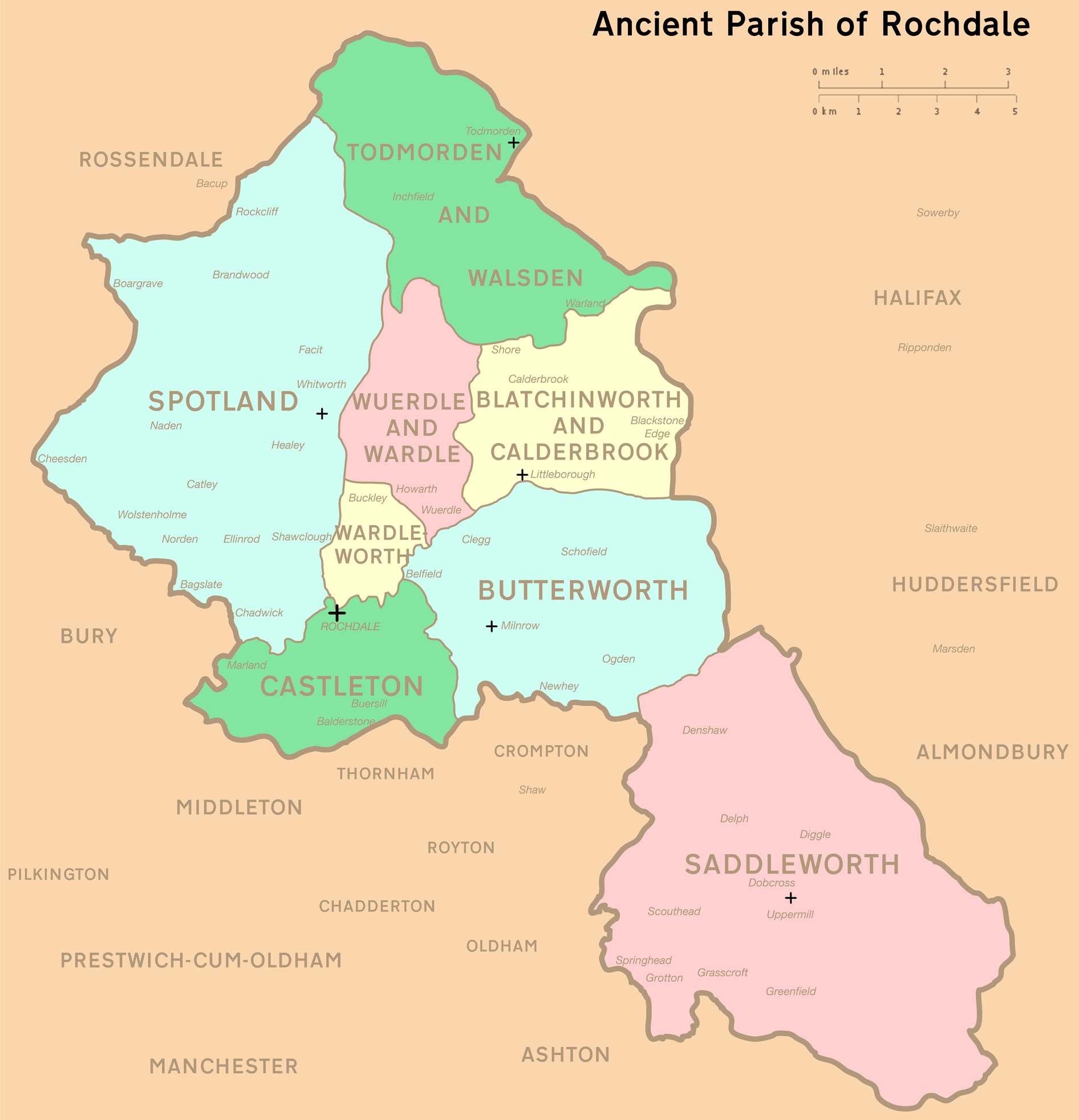
Rochdale was an ecclesiastical parish of early-medieval origin in northern England, administered from the Church of St Chad, Rochdale. At its zenith, it occupied of land amongst the South Pennines, and straddled the historic county boundary between Lancashire and the West Riding of Yorkshire. To the north and north-west was the parish of Whalley; to the southwest was the parish of Bury; to the south was Middleton and Prestwich-cum-Oldham. Anciently a dependency of Whalley Abbey, the parish of Rochdale is believed to be of Anglo-Saxon origin, as evidenced by historical documentation, toponymy and its dedication to Chad of Mercia. Urbanisation, population shifts, and local government reforms all contributed towards the gradual alteration and ultimate dissolution of the historic parish boundaries; the social welfare functions of the parish were broadly superseded by the English Poor Laws and new units of local governance, such as the County Borough of Rochdale and the Milnrow Ur ... [...More Info...] [...Related Items...] OR: [Wikipedia] [Google] [Baidu] |
Metropolitan Borough Of Rochdale
The Metropolitan Borough of Rochdale is a metropolitan borough of Greater Manchester in North West England. It is named after its largest town, Rochdale, The borough covers other outlying towns and villages with a population of 206,500 at the 2011 census. It is the ninth-largest district by population in Greater Manchester. History The borough was formed in 1974 as part of the provisions of the Local Government Act 1972 and is an amalgamation of six former local government districts. It was originally proposed that the borough include the neighbouring town of Bury and disclude Middleton; Bury however went on to form the administrative centre for the adjacent Metropolitan Borough of Bury. The borough was formed by a merger of the former county borough of Rochdale and from the administrative county of Lancashire, the municipal boroughs of Heywood and Middleton, along with the urban districts of Littleborough, Milnrow and Wardle.The borough lies mostly within the historic count ... [...More Info...] [...Related Items...] OR: [Wikipedia] [Google] [Baidu] |
Greater Manchester
Greater Manchester is a metropolitan county and combined authority, combined authority area in North West England, with a population of 2.8 million; comprising ten metropolitan boroughs: City of Manchester, Manchester, City of Salford, Salford, Metropolitan Borough of Bolton, Bolton, Metropolitan Borough of Bury, Bury, Metropolitan Borough of Oldham, Oldham, Metropolitan Borough of Rochdale, Rochdale, Metropolitan Borough of Stockport, Stockport, Tameside, Trafford and Metropolitan Borough of Wigan, Wigan. The county was created on 1 April 1974, as a result of the Local Government Act 1972, and designated a functional Manchester City Region, city region on 1 April 2011. Greater Manchester is formed of parts of the Historic counties of England, historic counties of Cheshire, Lancashire and the West Riding of Yorkshire. Greater Manchester spans , which roughly covers the territory of the Greater Manchester Built-up Area, the List of urban areas in the United Kingdom, second most ... [...More Info...] [...Related Items...] OR: [Wikipedia] [Google] [Baidu] |
England
England is a country that is part of the United Kingdom. It shares land borders with Wales to its west and Scotland to its north. The Irish Sea lies northwest and the Celtic Sea to the southwest. It is separated from continental Europe by the North Sea to the east and the English Channel to the south. The country covers five-eighths of the island of Great Britain, which lies in the North Atlantic, and includes over 100 smaller islands, such as the Isles of Scilly and the Isle of Wight. The area now called England was first inhabited by modern humans during the Upper Paleolithic period, but takes its name from the Angles, a Germanic tribe deriving its name from the Anglia peninsula, who settled during the 5th and 6th centuries. England became a unified state in the 10th century and has had a significant cultural and legal impact on the wider world since the Age of Discovery, which began during the 15th century. The English language, the Anglican Church, and Engli ... [...More Info...] [...Related Items...] OR: [Wikipedia] [Google] [Baidu] |
United Kingdom Census 2011
A Census in the United Kingdom, census of the population of the United Kingdom is taken every ten years. The 2011 census was held in all countries of the UK on 27 March 2011. It was the first UK census which could be completed online via the Internet. The Office for National Statistics (ONS) is responsible for the census in England and Wales, the General Register Office for Scotland (GROS) is responsible for the census in Scotland, and the Northern Ireland Statistics and Research Agency (NISRA) is responsible for the census in Northern Ireland. The Office for National Statistics is the executive office of the UK Statistics Authority, a non-ministerial department formed in 2008 and which reports directly to Parliament. ONS is the UK Government's single largest statistical producer of independent statistics on the UK's economy and society, used to assist the planning and allocation of resources, policy-making and decision-making. ONS designs, manages and runs the census in England an ... [...More Info...] [...Related Items...] OR: [Wikipedia] [Google] [Baidu] |
Historic Counties Of England
The historic counties of England are areas that were established for administration by the Normans, in many cases based on earlier Heptarchy, kingdoms and shires created by the Angles, Saxons, Jutes, Celts and others. They are alternatively known as ancient counties, traditional counties, former counties or simply as counties. In the centuries that followed their establishment, as well as their administrative function, the counties also helped define local culture and identity. This role continued even after the counties ceased to be used for administration after the creation of Administrative counties of England, administrative counties in 1889, which were themselves amended by further local government reforms in the years following. Unlike the partly self-governing Ancient borough, boroughs that covered urban areas, the counties of medieval England existed primarily as a means of enforcing central government power, enabling monarchs to exercise control over local areas throug ... [...More Info...] [...Related Items...] OR: [Wikipedia] [Google] [Baidu] |
Lancashire
Lancashire ( , ; abbreviated Lancs) is the name of a historic county, ceremonial county, and non-metropolitan county in North West England. The boundaries of these three areas differ significantly. The non-metropolitan county of Lancashire was created by the Local Government Act 1972. It is administered by Lancashire County Council, based in Preston, and twelve district councils. Although Lancaster is still considered the county town, Preston is the administrative centre of the non-metropolitan county. The ceremonial county has the same boundaries except that it also includes Blackpool and Blackburn with Darwen, which are unitary authorities. The historic county of Lancashire is larger and includes the cities of Manchester and Liverpool as well as the Furness and Cartmel peninsulas, but excludes Bowland area of the West Riding of Yorkshire transferred to the non-metropolitan county in 1974 History Before the county During Roman times the area was part of the Bri ... [...More Info...] [...Related Items...] OR: [Wikipedia] [Google] [Baidu] |
Township (England)
In England, a township (Latin: ''villa'') is a local division or district of a large parish containing a village or small town usually having its own church. A township may or may not be coterminous with a chapelry, manor, or any other minor area of local administration. The township is distinguished from the following: *Vill: traditionally, among legal historians, a ''vill'' referred to the tract of land of a rural community, whereas ''township'' was used when referring to the tax and legal administration of that community. *Chapelry: the 'parish' of a chapel (a church without full parochial functions). *Tithing: the basic unit of the medieval Frankpledge system. 'Township' is, however, sometimes used loosely for any of the above. History In many areas of England, the basic unit of civil administration was the parish, generally identical with the ecclesiastical parish. However, in some cases, particularly in Northern England, there was a lesser unit called a township, being a ... [...More Info...] [...Related Items...] OR: [Wikipedia] [Google] [Baidu] |
Primary School
A primary school (in Ireland, the United Kingdom, Australia, Trinidad and Tobago, Jamaica, and South Africa), junior school (in Australia), elementary school or grade school (in North America and the Philippines) is a school for primary education of children who are four to eleven years of age. Primary schooling follows pre-school and precedes secondary schooling. The International Standard Classification of Education considers primary education as a single phase where programmes are typically designed to provide fundamental skills in reading, writing, and mathematics and to establish a solid foundation for learning. This is ISCED Level 1: Primary education or first stage of basic education.Annex III in the ISCED 2011 English.pdf Navigate to International Standard Classification of Educati ... [...More Info...] [...Related Items...] OR: [Wikipedia] [Google] [Baidu] |


