|
South Gujarat
South Gujarat, also known as ''Dakshin Gujarat'' (''દક્ષિણ ગુજરાત''), is a region in the Indian state of Gujarat. The region has a wetter climate than other regions of Gujarat. The western part is almost coastal and is known as ''Kantha Vistar'' ("coastal expanse" in Gujarati), and the eastern part is also known as ''Dungar Vistar'' ("hilly expanse"), which ranges from 100 to 1000 metres, with the highest peak at Saputara in the Dang district. Headquarters and districts Surat the largest city in this region, and the second largest in Gujarat and eight largest in India, is the headquarters of South Gujarat region. The districts in this region are Surat district, Bharuch district, Navsari district, Dang district, Valsad district, Narmada district and Tapi district. Other important cities are Bharuch, Ankleshwar, Navsari, Vyara, Valsad, Pardi, Bardoli, Vapi, Jambusar, Bilimora, Amalsad, Rajpipla and Songadh. Notable South Gujarat Politicians * Mora ... [...More Info...] [...Related Items...] OR: [Wikipedia] [Google] [Baidu] |
States And Territories Of India
India is a federal union comprising 28 states and 8 union territories, with a total of 36 entities. The states and union territories are further subdivided into districts and smaller administrative divisions. History Pre-independence The Indian subcontinent has been ruled by many different ethnic groups throughout its history, each instituting their own policies of administrative division in the region. The British Raj mostly retained the administrative structure of the preceding Mughal Empire. India was divided into provinces (also called Presidencies), directly governed by the British, and princely states, which were nominally controlled by a local prince or raja loyal to the British Empire, which held ''de facto'' sovereignty ( suzerainty) over the princely states. 1947–1950 Between 1947 and 1950 the territories of the princely states were politically integrated into the Indian union. Most were merged into existing provinces; others were organised into ... [...More Info...] [...Related Items...] OR: [Wikipedia] [Google] [Baidu] |
Navsari District
Navsari is an administrative district in the state of Gujarat in India, with its headquarters at the city of Navsari. The district covers an area of 2,211 square kilometres and was formed in 1997 after Valsad district was split into Valsad and Navsari districts. The city picked up a greater pace commercially during the diamond polishing business soared in the region. Demographics According to the 2011 census Navsari district has a population of 1,329,672, roughly equal to the nation of Estonia or the US states of Maine or Hawaii. The census shows that 678,165 (51%) of the population is male and 651,507 (49%) of it is female, this ranks Nasvari district 366th in India, out of a total of 640 districts. Scheduled Castes and Scheduled Tribes make up 2.07% and 48.11% of the population respectively. Children below 6 years old account for just 9.73% of the population, the lowest in Gujarat, and is composed of 52% male and 48% female. There are about 295,131 households in the district ... [...More Info...] [...Related Items...] OR: [Wikipedia] [Google] [Baidu] |
Bilimora
Bilimora is a city situated on the banks of the river Ambika River, Ambika, in Gandevi taluka & Navsari district of Gujarat state, in India. The city comes under the purview of the Surat Metropolitan Region. The city is roughly south of the city of Surat and is the southernmost point of the Surat Metropolitan Region and the Metropolis of Surat. It is linked to Surat by State Highway (India), SH 6 and State Highway (India), SH 88. In the late 18th century, the Baroda State established a naval station at Bilimora, a port about south of Surat, known as ''Bunder Bilimora Suba Armor''. A fleet of 50 vessels were stationed here, mostly sailboats, cargo vessels for trading and military vessels to secure the sea from the Portugal, Portuguese, the Netherlands, Dutch and the France, French. Geography Bilimora is located at . It has an average elevation of . Bilimora is the second largest city in the Navsari district after Navsari city. The city is supposed to have been surrounded by ... [...More Info...] [...Related Items...] OR: [Wikipedia] [Google] [Baidu] |
Jambusar
Jambusar is a town and a municipality in Bharuch district in the Indian state of Gujarat Gujarat (, ) is a state along the western coast of India. Its coastline of about is the longest in the country, most of which lies on the Kathiawar peninsula. Gujarat is the fifth-largest Indian state by area, covering some ; and the ninth .... Geography Jambusar has an average elevation of 4 metres (13 feet). Demographics The Jambusar Municipality has population of 50,000 of which 27,000 are males while 23,000 are females as per report released by Census India 2019. Population of Children with age of 0-6 is 5155 which is 11.89% of total population of Jambusar (M). In Jambusar Municipality, Female Sex Ratio is of 929 against state average of 919. Moreover, Child Sex Ratio in Jambusar is around 936 compared to Gujarat state average of 890. Literacy rate of Jambusar city is 82.36% higher than state average of 78.03%. In Jambusar, Male literacy is around 88.90% while female ... [...More Info...] [...Related Items...] OR: [Wikipedia] [Google] [Baidu] |
Vapi
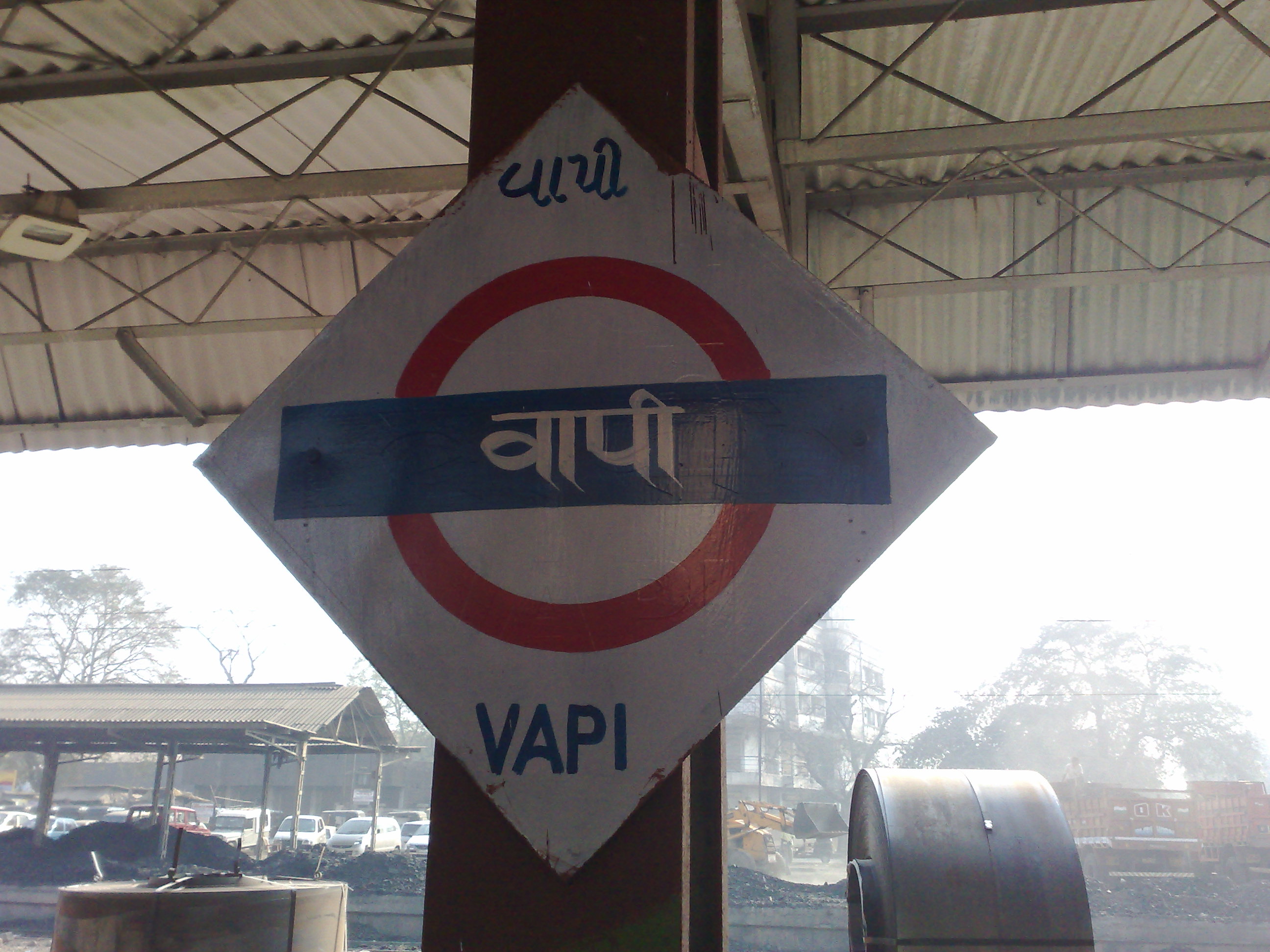
Vapi ( IAST: vāpī,), is a city and municipality in Valsad district in the state of Gujarat, India.It is situated near the banks of the Daman Ganga River, around 28 km south of the district headquarters in the city of Valsad, and it is surrounded by the Union Territory of Dadra and Nagar Haveli and Daman and Diu. It is believed that the city got its name from the old small stepwell situated near the Balitha area. The meaning of vapi (''वापी'') in sanskrit is a water reservoir or a water storage body. The town originally belonged to the Kshatriya Jagirdar family Palande during the Marathi Empire. After independence from the British Crown, the Jagirdar system was abolished by the Indian government in 1951 and the community of Anavil Brahmin who formerly acted as tax farmers during the era of the Maratha Empire received the land. Vapi is one of the largest industrial areas in Gujarat in terms of small-scale industries, dominated by the chemical industry. Geogra ... [...More Info...] [...Related Items...] OR: [Wikipedia] [Google] [Baidu] |
Bardoli
Bardoli is a town and a municipality in Surat Metropolitan Region in the state of Gujarat, India. Geography Bardoli is located at . It has an average elevation of 22 metres (72 feet). Weather Bardoli is having average rainfall of 1487 mm for the last 30 years (I.e., 1992-2021). Bardoli has received 864 mm, 876 mm, 934 mm, 1504 mm, 1567 mm, 2089 mm, 1585 mm, and 2017 mm during the years 2015, 2016, 2017, 2018, 2019, 2020, 2021, and 2022 respectively. http://www.gsdma.org/rainfalldata-2?Type=2. January is with temperature in the range of an average low of 18.6°C (65.5°F) and an average high of 31°C (87.8°F). February is with an average temperature fluctuating between 20.3°C (68.5°F) and 33.4°C (92.1°F). March is with an average temperature ranging between min 23.2°C (73.8°F) and max 36.4°C (97.5°F). April is with an average temperature between 25.8°C (78.4°F) and 38.5°C (101.3°F). May is with an average temperature between 27.6°C (81.7°F) and 38.2°C (1 ... [...More Info...] [...Related Items...] OR: [Wikipedia] [Google] [Baidu] |
Pardi
Pardi is a town and a municipality in Valsad district in the Indian state of Gujarat. Historically, there is a Hill in the middle of the town facing the lake where it is said Shivaji built the Killa (Fort). It's from this Killa (Fort) that the town is also called Killa-Pardi. Roughly 14 km south of the district headquarters city of Valsad, has a rail station on the Mumbai-Vadodara line of Western Railway (India). National Highway 8 bisects the town in east and west regions. The town has a municipality office and a court. The town centre also known for the Bus Stop at the intersection of Roads from Chival (East), Umarsadi (West), Damni Zampa (South) and Valsadi Zampa (North). Pardi has a wonderful lake called Talav spread over 99 acres which is proposed to be made tourist place in the near future. The city of Vapi, a large industrial township for small-scale industries, Roughly 14 km south of Pardi town. Pardi has its own industrial zone which is governed by GIDC and ... [...More Info...] [...Related Items...] OR: [Wikipedia] [Google] [Baidu] |
Valsad
Valsad (Pronunciation: �alsɑɖ (Gujarati: વલસાડ), historically known as Bulsar, is a city and a municipality in Valsad district of the Indian state of Gujarat. It is the district headquarters of Valsad district. The city of Valsad is located in the south of Navsari and Surat. Etymology The name "Valsad" derives from ''vad-saal'', a Gujarati language compound meaning "covered (''saal'') by banyan trees (''vad'')" (the area was naturally rich in banyan trees). During British Raj, it was historically known as "Bulsar". Geography Valsad is located at . It has an average elevation of 13 metres (42 feet). The old city is about 4 km inland from the Arabian sea. Climate Valsad has a tropical savanna climate (Aw) with little to no rainfall from October to May and very heavy to extremely heavy rainfall from June to September when it is under the direct influence of the Arabian Sea branch of the South-west monsoon. Demographics As of the 2011 Ind ... [...More Info...] [...Related Items...] OR: [Wikipedia] [Google] [Baidu] |
Vyara
Vyara is a town and the district headquarters of the Tapi district in the Indian state of Gujarat. It is 65 kilometres from Surat. Demographics India census, Vyara had a population of 36,213. Males constitute 49% of the population and females 51%. Vyara has an average literacy rate of 74%, higher than the national average of 59.5%: male literacy is 78%, and female literacy is 69%. In Vyara, 8% of the population is under 6 years of age. In Vyara district, 39% population belongs from Scheduled Tribe and 2.4% population belongs from Scheduled Castes. Dhodia, Gamit, Chaudhari, Vasava, Konkani, Brahmin, Jain, Sindhi, Bhoy, Christian, Muslim and Parsi population lives in the district. Geography Vyara is located at . 65 km away from surat on nh6. It has an average elevation of 69 metres (226 feet). History Vyara town was ruled by Gaekwads of the Princely State of Baroda during 1721 until 1949 when it joined the Indian union, the region also lied under Princely State of ... [...More Info...] [...Related Items...] OR: [Wikipedia] [Google] [Baidu] |
Navsari
Navsari is the ninth biggest city in the state of Gujarat in India. It is the administrative headquarters of Navsari District. Navsari is situated between Surat & Mumbai. Navsari is a twin city of Surat. It is located 37 km south of Surat. As per 2011 Census of India, Navsari is 16th biggest city of Gujarat state. It ranked 10th most populous city of Gujarat in 1991 Census of India and 2001 Census of India. Navsari is the 23rd "cleanest city of India" located in the west zone according to the Swachh Bharat Urban mission. Dandi village near Navsari was the focal point of the great Salt March led by Mahatma Gandhi during civil disobedience movement of India. History Navsari was originally known as "Navasarika", and was the capital of a ''vishya'' (an administrative unit) in the Lata region. It is identified with "Nusaripa", a city mentioned in Ptolemy's 2nd century Greek-language work ''Geography''. The Chalukyas of Navasarika, who governed the area around Navsari as s ... [...More Info...] [...Related Items...] OR: [Wikipedia] [Google] [Baidu] |
Ankleshwar
Ankleshwar (sometimes written Ankaleshwar) is a city and a municipality in Bharuch district in the state of Gujarat, India. The city is located 14 kilometres from Bharuch. Ankleshwar Industrial Association (AIA) is the largest organisation of the Gujarat Industrial Development Corporation, where over 2000 industries are registered. Economy The town is known for its industrial township called Gujarat Industrial Development Corporation (GIDC). Ankleshwar has an office of the ONGC (Oil and Natural Gas Corporation Limited). Ankleshwar has over 1500 chemical plants, producing products such as pesticides, pharmaceuticals, chemicals and paints. GIDC has started organizing Trade fair and Industrial expo occasionally to attract large number of industries all over from India. It also helps to get customers on large basis. MNC companies like Siemens ABB and GM have their offices at Ankleshwar. Demographics India census, Ankleshwar had a population of 140,839. A very large populati ... [...More Info...] [...Related Items...] OR: [Wikipedia] [Google] [Baidu] |
Bharuch
Bharuch (), formerly known as Broach, is a city at the mouth of the river Narmada in Gujarat in western India. Bharuch is the administrative headquarters of Bharuch District. The city of Bharuch and surroundings have been settled since times of antiquity. It was a ship building centre and sea port in the pre-compass coastal trading routes to points West, perhaps as far back as the days of the pharaohs. The route made use of the regular and predictable monsoon winds or galleys. Many goods from the Far East (the famed Spice and Silk trade) were shipped there during the annual monsoon winds, making it a terminus for several key land-sea trade routes. Bharuch was known to the Greeks, the various Persian Empires, in the Roman Republic and Empire, and in other Western centres of civilisation through the end of the European Middle Ages.Periplus of the Erythraean Sea [...More Info...] [...Related Items...] OR: [Wikipedia] [Google] [Baidu] |


