|
Skryje (Rakovník District)
Skryje is a municipality and village in Rakovník District in the Central Bohemian Region of the Czech Republic. It has about 200 inhabitants. The historic centre of the village is well preserved and is protected as a village monument zone. Etymology The word ''skryj'' denoted a person who was hiding or who was hiding something. The name Skryje denoted the village where such people lived. Geography Skryje is located about south of Rakovník and west of Prague. The northern part of the municipal territory lies in the Plasy Uplands, the southern part lies in the Křivoklát Highlands. The highest point is the hill Vlastec at above sea level. The municipality is situated on the right bank of the Berounka River. The entire municipality is located within the Křivoklátsko Protected Landscape Area. History The first written mention of Skryje is from 1239, when it was owned by the Kladruby Abbey. From 1375 to 1601, the village was owned by various lower nobility. From 1601 until th ... [...More Info...] [...Related Items...] OR: [Wikipedia] [Google] [Baidu] |
Obec
(, ; plural ) is the Czech and Slovak word for a municipality (in the Czech Republic, in Slovakia and abroad). The literal meaning of the word is " commune" or " community". It is the smallest administrative unit that is governed by elected representatives. Cities and towns are also municipalities. Definition The legal definition (according to the Czech code of law with similar definition in the Slovak code of law) is: ''"The municipality is a basic territorial self-governing community of citizens; it forms a territorial unit, which is defined by the boundary of the municipality."'' Every municipality is composed of one or more cadastral areas. Every municipality is also composed of one or more municipal parts (), which are usually town quarters or villages. A municipality can have its own flag and coat of arms. Czech Republic Almost the entire area of the Czech Republic is divided into municipalities, with the only exception being military training areas. The smaller mu ... [...More Info...] [...Related Items...] OR: [Wikipedia] [Google] [Baidu] |
Plasy Uplands
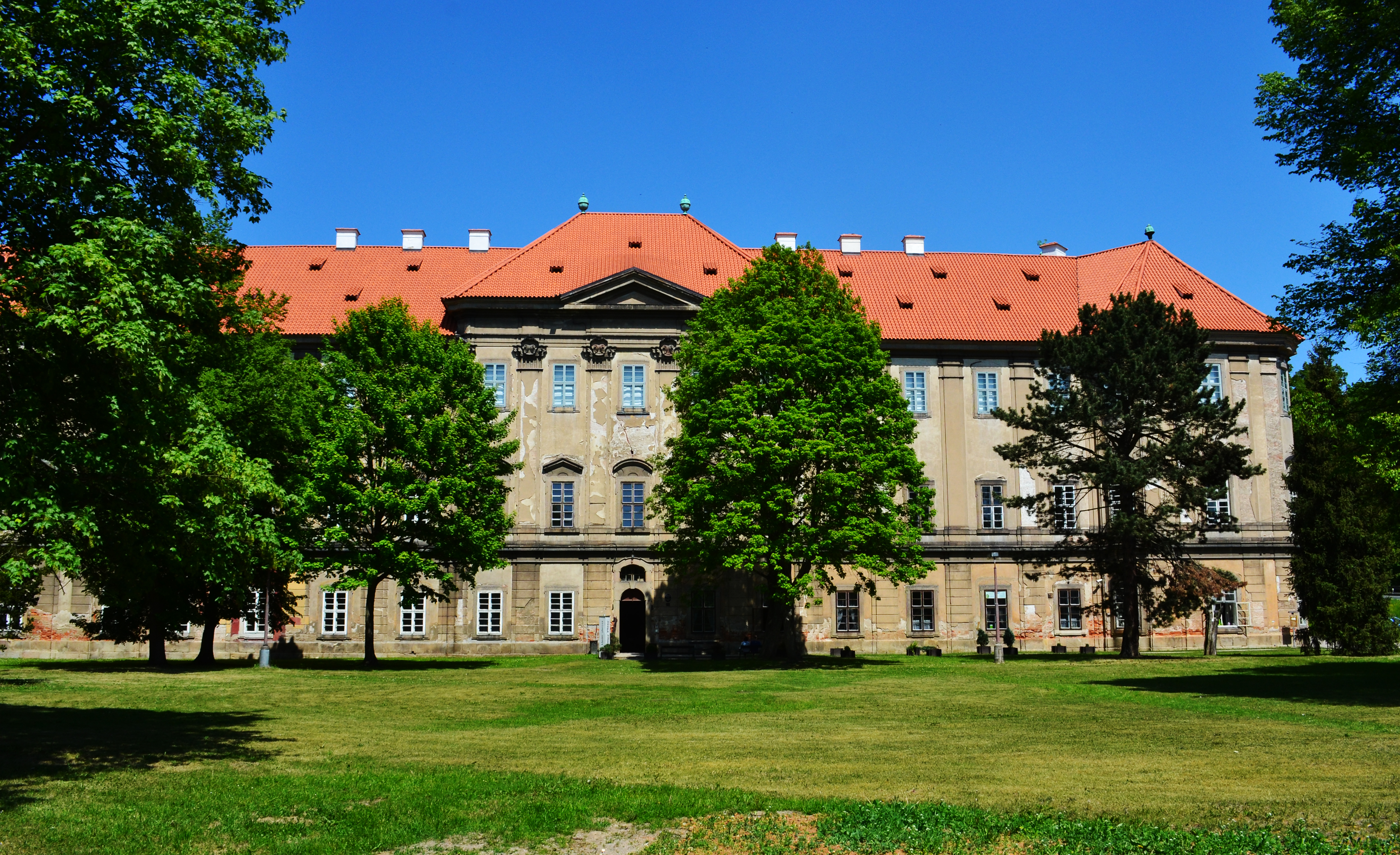
Plasy (; ) is a town in Plzeň-North District in the Plzeň Region of the Czech Republic. It has about 2,900 inhabitants. It is known for its former monastery of the same name, which is protected as a national cultural monument. Administrative division Plasy consists of six municipal parts (in brackets population according to the 2021 census): *Plasy (1,891) *Babina (214) *Horní Hradiště (168) *Lomnička (80) *Nebřeziny (179) *Žebnice (158) Geography Plasy is located about north of Plzeň. It lies in the Plasy Uplands. The highest point is the hill Spálená hora at above sea level. The Střela River flows through the town. History The foundation of the town is connected with the foundation of the Cistercian monastery. The Plasy Monastery was founded in 1144 by then Prince Vladislaus II. The monastery experienced the greatest development during the reign of King Wenceslaus I, and its property gradually grew to cover 50 surrounding villages. The development of the mon ... [...More Info...] [...Related Items...] OR: [Wikipedia] [Google] [Baidu] |
Joachim Barrande
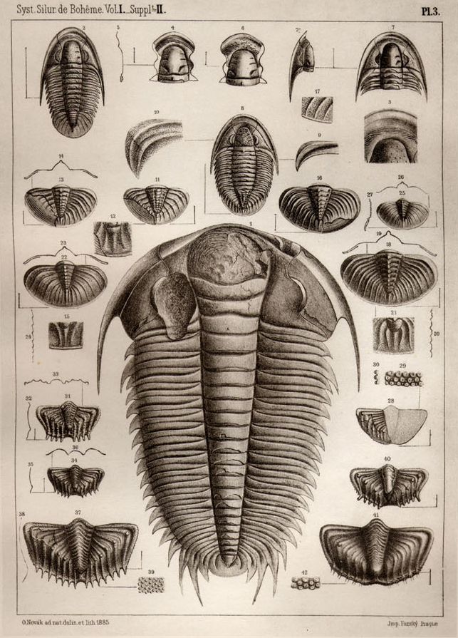
Joachim Barrande (11 August 1799 – 5 October 1883) was a French geologist and palaeontologist. He was particularly known for his work on trilobites, published in the ''Systéme Silurien de la Bohéme'' which he published in 22 parts. Trained under the school of Georges Cuvier, he opposed the evolutionary views of Charles Darwin. Life and career Barrande was born on the family estate at Saugues, Haute Loire, and he was educated in the École Polytechnique and École Nationale des Ponts et Chaussées at Paris. He attended the lectures of Georges Cuvier, Brongniart, Jussieu, Prevost, Serres, Auduoin, and de Blainville. He received the training of an engineer and was initially appointed engineer at Decize where he built an acqueduct over the Loire. While living in Decize he was introduced to Louis-Antoine de Bourbon, duke d'Angoulême and he was then appointed tutor to family of the duc de Bordeaux (afterwards known as the comte de Chambord), grandson of Charles X. He set ... [...More Info...] [...Related Items...] OR: [Wikipedia] [Google] [Baidu] |
Křivoklát Castle
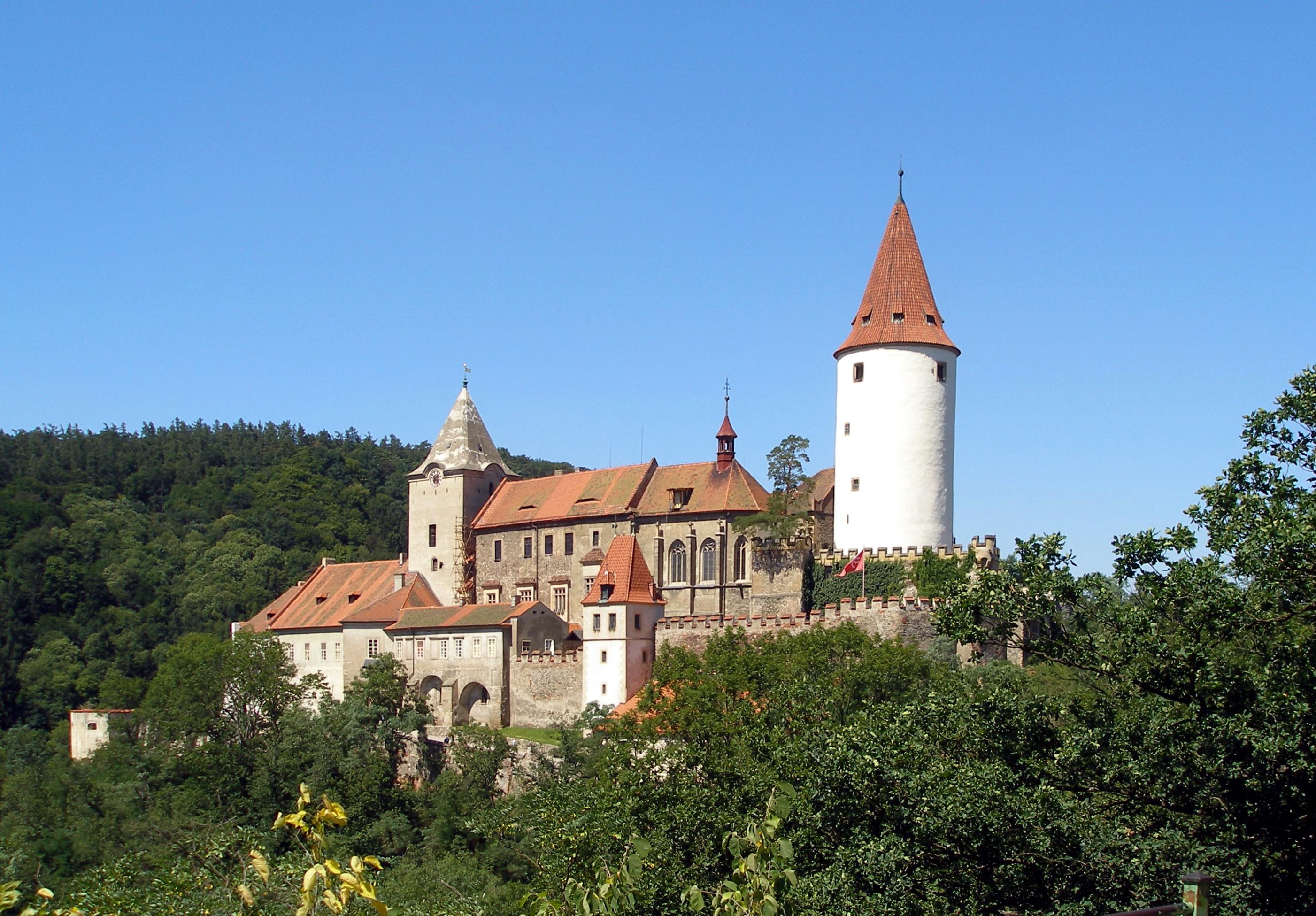
Křivoklát Castle () is a castle in Křivoklát in the Central Bohemian Region of the Czech Republic. It is protected as a national cultural monument. History Křivoklát was founded in the 12th century, belonging to the kings of Bohemia. During the reign of Otakar II of Bohemia a large, monumental royal castle was built, later rebuilt by King Wenceslaus IV and later enlarged by King Vladislaus II. The castle was damaged by fire several times. It was turned into a harsh prison and the building slowly deteriorated. During the 19th century, the Fürstenberg family became the owners of the castle and had it reconstructed after a fire in 1826. The Fürstenberg family owned the castle until 1929. Today the castle serves as a museum, tourist destination and place for theatrical exhibitions. Collections of hunting weapons, Gothic paintings and books are stored there. Gallery Wenceslas Hollar - Bohemian views 11 (cropped).jpg, Křivoklát on an engraving by Wenceslaus Hollar ... [...More Info...] [...Related Items...] OR: [Wikipedia] [Google] [Baidu] |
Kladruby (Tachov District)
Kladruby () is a town in Tachov District in the Plzeň Region of the Czech Republic. It has about 1,700 inhabitants. Administrative division Kladruby consists of seven municipal parts (in brackets population according to the 2021 census): *Kladruby (1,279) *Brod u Stříbra (67) *Láz (48) *Milevo (45) *Pozorka (41) *Tuněchody (30) *Vrbice u Stříbra (47) Etymology The name Kladruby is a common Czech name of settlements, derived from ''kláda'' (i.e. 'log') and ''rubat'' (i.e. 'to chop'). This name was used for settlements where lumberjacks lived. Geography Kladruby is located about west of Plzeň. It lies in the Plasy Uplands. The highest point is the hill Pastvina at above sea level. The Úhlavka River flows through the town. History The Kladruby village was founded together with the Kladruby Monastery in 1115. Around 1233, a new royal town was founded by King Wenceslaus I of Bohemia, Wenceslaus I. Due to power struggles between the King Wenceslaus IV of Bohemia, Wencesla ... [...More Info...] [...Related Items...] OR: [Wikipedia] [Google] [Baidu] |
Křivoklátsko Protected Landscape Area
Křivoklátsko Protected Landscape Area (abbreviated as Křivoklátsko PLA; ) is a protected landscape area in the Czech Republic. Geography Křivoklátsko PLA lies in the western part of the Central Bohemian Region, only a small part extends into the northeastern Plzeň Region. The distance between the eastern edge of the PLA and the western edge of Prague is about . From a geomorphological point of view, most of the PLA is situated in the Křivoklát Highlands. The western part lies in the Plasy Uplands. To a small extent, the PLA extends into the Rakovník Uplands in the north and the Hořovice Uplands in the south. Křivoklátsko PLA covers an area of . The highest point is the Těchovín hill at above sea level. The lowest point is at . The axis of the PLA is the Berounka River. The canyon-like river valley with preserved meanders and valley floodplain is one of the main characteristics of the area. Within the PLA, the Berounka has 17 left-sided and 15 right-sided tr ... [...More Info...] [...Related Items...] OR: [Wikipedia] [Google] [Baidu] |
Berounka
The Berounka () is a river in the Czech Republic, a left tributary of the Vltava River. It flows through the Plzeň Region, Plzeň and Central Bohemian Region, Central Bohemian regions to Prague. It is formed by the confluence of the Mže and Radbuza rivers in Plzeň. Together with the Mže, which is its main source, the Berounka is long, which makes it the List of rivers of the Czech Republic, fifth longest river in the Czech Republic. Without the Mže, it is long. Etymology The river is named after the town of Beroun. Originally, the entire stream was called Mže () and the name first appeared in the 12th century, among others in ''Chronica Boemorum''. The name was written as ''Mse'', ''Msa'' and ''Misa''. From the 17th century, the lower course started to be named Berounka, but the name Mže still appeared as a name for the entire stream at the end of the 19th century. In order to avoid confusion, an initiative to rename the lower course back to the historical name Mže was cre ... [...More Info...] [...Related Items...] OR: [Wikipedia] [Google] [Baidu] |
Křivoklát Highlands
Křivoklát () is a market town in Rakovník District in the Central Bohemian Region of the Czech Republic. It has about 700 inhabitants. It is known for the medieval Křivoklát Castle, protected as national cultural monument. Administrative division Křivoklát consists of three municipal parts (in brackets population according to the 2021 census): *Křivoklát (623) *Častonice (35) *Písky (25) Etymology The initial name of Křivoklát was Krivoplát. It was derived from Czech words (i.e. 'crooked plate') and probably referred to the non-flat terrain where the castle was founded. In the 14th century, the name was distorted to Křivoklát. Geography Křivoklát is located about southeast of Rakovník and west of Prague. It lies in the Křivoklát Highlands. The highest point is at above sea level. The market town is situated in the meander of the Berounka River at its confluence with the stream Rakovnický potok, which flows west of Křivoklát below the castle. The e ... [...More Info...] [...Related Items...] OR: [Wikipedia] [Google] [Baidu] |
Prague
Prague ( ; ) is the capital and List of cities and towns in the Czech Republic, largest city of the Czech Republic and the historical capital of Bohemia. Prague, located on the Vltava River, has a population of about 1.4 million, while its Prague metropolitan area, metropolitan area is home to approximately 2.3 million people. Prague is a historical city with Romanesque architecture, Romanesque, Czech Gothic architecture, Gothic, Czech Renaissance architecture, Renaissance and Czech Baroque architecture, Baroque architecture. It was the capital of the Kingdom of Bohemia and residence of several Holy Roman Emperors, most notably Charles IV, Holy Roman Emperor, Charles IV (r. 1346–1378) and Rudolf II, Holy Roman Emperor, Rudolf II (r. 1575–1611). It was an important city to the Habsburg monarchy and Austria-Hungary. The city played major roles in the Bohemian Reformation, Bohemian and the Protestant Reformations, the Thirty Years' War and in 20th-century history a ... [...More Info...] [...Related Items...] OR: [Wikipedia] [Google] [Baidu] |
Regions Of The Czech Republic
Regions of the Czech Republic ( ; singular ) are higher-level territorial self-governing units of the Czech Republic. History The first regions (''kraje'') were created in the Kingdom of Bohemia in the 14th century. At the beginning of the 15th century, Bohemia was already divided into 12 regions, but their borders were not fixed due to the frequent changes in the borders of the estates. During the reign of George of Poděbrady (1458–1471), Bohemia was divided into 14 regions, which remained so until 1714, when their number was reduced to 12 again. From 1751 to 1850, after the four largest regions were divided, the kingdom consisted of 16 regions. Between 1850 and 1862, there were several reforms and the number of regions fluctuated between 7 and 13. Due to the parallel establishment of political districts in 1848, however, their importance declined. In 1862, the regions were abolished, although the regional authorities had some powers until 1868. Moravia was divided into ... [...More Info...] [...Related Items...] OR: [Wikipedia] [Google] [Baidu] |


