|
Sjodalen
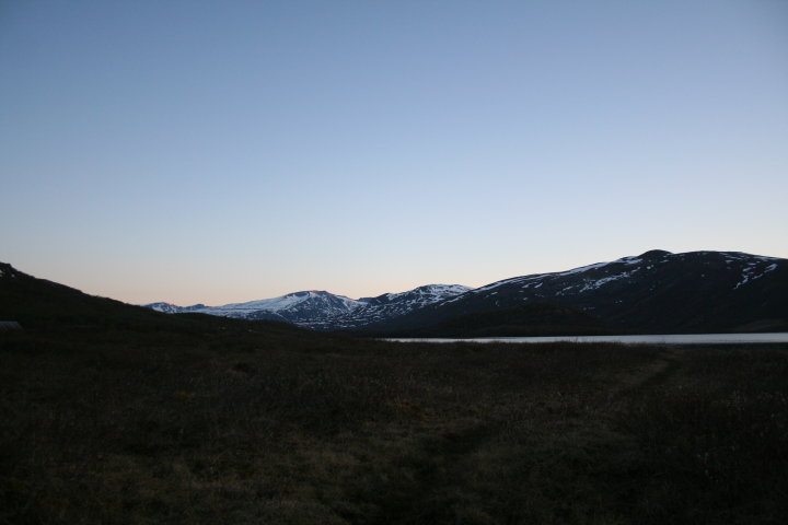
Sjodalen is a wide, gently sloping valley in Southern Norway, draining the eastern parts of Jotunheimen. The river Sjoa gives its name to the valley. Sjodalen is generally accepted to start at the outlet from the deep mountain-lake Gjende. The valley's lower end-point is, however less defined as the valley is named Heidal east of Randsverk. Perhaps the most easy definition is to state that the valley draining Sjoa is named Sjodalen in Vågå and Heidal in Sel municipalities. History The valley was traditionally used for summer farming. What is particular for the valley is the size and state of these summer farms ('' sæter'' in Norwegian). This is partly caused by the very rare tradition of winter-farming in this region. Rather than bringing the summer harvest down into the village and main farm, the farmers took the animals back up into the mountains during winter. This could be done due to the limited snow-fall in this continental climate regime. The perhaps best-known tourist ... [...More Info...] [...Related Items...] OR: [Wikipedia] [Google] [Baidu] |
Sjoa
The Sjoa is a river in Innlandet county, Norway. The long river runs through the municipalities of Vågå and Sel and it provides the outlet from lake Gjende at Gjendesheim in the Jotunheimen mountains of Norway's Jotunheim National Park. The river flows eastward through the Sjodalen valley and Heidal valley into the Gudbrandsdalslågen river at the village of Sjoa. South of the village of Randsverk, the river flows through ''Ridderspranget'' which is a ravine named after a Norwegian myth. Rafting, kayaking and fishing The river is used for kayaking, rafting and fishing. Thirteen deaths have occurred in the river, from 1989 to 2010. This includes four deaths involving a group of tourists in various inflatable " catarafts", on 24 July 2010 (a national newspaper claimed that at that time the level of the river was above a safe level for rafting).Dagbladet ''Dagbladet'' (lit.: ''The Daily Magazine'') is one of Norway's largest newspapers and is published in the tabloid for ... [...More Info...] [...Related Items...] OR: [Wikipedia] [Google] [Baidu] |
Bessheim
{{coord, 61, 30, 53, N, 8, 51, 12, E, type:landmark_region:NO_scale:5000, display=title Bessheim is a mountain lodge in Sjodalen and is situated 964 metres above sea level next to Øvre Sjodalsvatnet on the mountain passage between Valdres and Gudbrandsdalen ( Riksveg 51 over Valdresflya). Bessheim consists of 30 buildings and has 150 beds and its own power generator. In addition to the lodge, which has 65 beds and a dining hall with room for 130 guests, there are cabins, apartments, and a campground. History Originally Bessheim was a seter Transhumance is a type of pastoralism or nomadism, a seasonal movement of livestock between fixed summer and winter pastures. In montane regions (''vertical transhumance''), it implies movement between higher pastures in summer and lower vall ... (summer farm) for the farm Nordigard Storvik and started receiving tourists at the end of the 1800s. The original seter house is still part of the lodge. Kari Lund and Ragnhild Sjurgard ar ... [...More Info...] [...Related Items...] OR: [Wikipedia] [Google] [Baidu] |
Heidal
Heidal or Heidalen is a valley in Sel Municipality in Innlandet county, Norway. The U-shaped valley follows the river Sjoa which begins in the nearby Jotunheimen mountains eastward until it joins the Gudbrandsdalslågen river in the main valley which runs through the region, Gudbrandsdalen. The western end of the Sjoa river valley is in Vågå Municipality and there, it is called the Sjodalen valley. From 1908-1965, the Heidal valley was an independent municipality called Heidal, and since 1965, it has been a part of Sel Municipality. The main urban area in the valley is the village of Bjølstad. The valley runs northwest from the village of Sjoa for about to the village of Bjølstad where the valley curves to the southwest/south for about before entering Vågå municipality. After entering Vågå, the valley becomes much narrower as it enters into the Jotunheimen mountains and heading to the source of the river, the large lake Gjende. History In the year 1177, Ivar Gjæsling ... [...More Info...] [...Related Items...] OR: [Wikipedia] [Google] [Baidu] |
Vågå
Vågå () is a municipality in Innlandet county, Norway. It is located in the traditional district of Gudbrandsdal. The administrative centre of the municipality is the village of Vågåmo. Other village areas in Vågå include Lalm and Bessheim. The municipality is the 73rd largest by area out of the 356 municipalities in Norway. Vågå is the 212th most populous municipality in Norway with a population of 3,591. The municipality's population density is and its population has decreased by 4% over the previous 10-year period. General information The prestegjeld of ''Vaage'' was established as a municipality on 1 January 1838 (see formannskapsdistrikt law). On 1 January 1908, the municipality was divided into three parts. The northeastern part of Vågå (population: 2,287) became Sel Municipality, the southeastern part (population: 1,241) became Hedalen Municipality, and the remaining areas in the west (population: 2,953) remained as Vågå municipality. During the 1960s, the ... [...More Info...] [...Related Items...] OR: [Wikipedia] [Google] [Baidu] |
Nappe
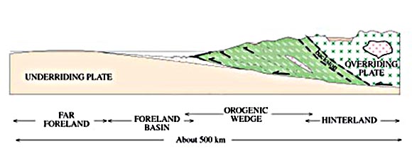
In geology, a nappe or thrust sheet is a large sheetlike body of rock (geology), rock that has been moved more than or above a thrust fault from its original position. Nappes form in compressional tectonic settings like continental collision zones or on the overriding plate in active subduction zones. Nappes form when a mass of rock is forced (or thrust fault, "thrust") over another rock mass, typically on a low angle fault plane. The resulting structure may include large-scale recumbent Fold (geology), folds, shearing along the fault plane,Twiss, Robert J. and Eldridge M. Moores, ''Structural Geology,'' W. H. Freeman, 1992, p. 236 Thrust fault#Thrust duplex, imbricate thrust stacks, Window (geology), fensters and klippes. The term stems from the French word for ''tablecloth'' in allusion to a rumpled tablecloth being pushed across a table. History Nappes or nappe belts are a major feature of the European Geology of the Alps, Alps, Dinaric Alps, Dinarides, Carpathians and S ... [...More Info...] [...Related Items...] OR: [Wikipedia] [Google] [Baidu] |
Maurvangen
Maurvangen is a campground by Øvre Sjodalsvatnet and a short distance from Gjendesheim. There are 26 cabins as well as camping spots for tents and caravans. A service building contains toilets, shower rooms, sauna, and a washing machine. It is located about 1,000 meters above sea level and lies next to the river Sjoa which is a popular fishing area. Maurvangen has a small shop that sells food, hunting and fishing licenses, and a small restaurant that serves local homemade food. Maurvangen is owned and operated by the family Moen who are originally from Vågå Vågå () is a municipality in Innlandet county, Norway. It is located in the traditional district of Gudbrandsdal. The administrative centre of the municipality is the village of Vågåmo. Other village areas in Vågå include Lalm and Besshe .... External linksMaurvangen web site Campsites in Norway Vågå Jotunheimen {{Camping-stub ... [...More Info...] [...Related Items...] OR: [Wikipedia] [Google] [Baidu] |
Kayaking
Kayaking is the use of a kayak for moving over water. It is distinguished from canoeing by the sitting position of the paddler and the number of blades on the paddle. A kayak is a low-to-the-water, canoe-like boat in which the paddler sits facing forward, legs in front, using a double-bladed paddle to pull front-to-back on one side and then the other in rotation. Most kayaks have closed decks, although sit-on-top and inflatable kayaks are growing in popularity as well. History Kayaks were created thousands of years ago by the Inuit, formerly known as Eskimos, of the northern Arctic regions. They used driftwood and sometimes the skeleton of whale, to construct the frame of the kayak, and animal skin, particularly seal skin was used to create the body. The main purpose for creating the kayak, which literally translates to "hunter's boat" was for hunting and fishing. The kayak's stealth capabilities allowed for the hunter to sneak up behind animals on the shoreline and successf ... [...More Info...] [...Related Items...] OR: [Wikipedia] [Google] [Baidu] |
Rafting
Rafting and whitewater rafting are recreational outdoor activities which use an inflatable raft to navigate a river or other body of water. This is often done on whitewater or different degrees of rough water. Dealing with risk is often a part of the experience. This activity as an adventure sport has become popular since the 1950s, if not earlier, evolving from individuals paddling to rafts with double-bladed paddles or oars to multi-person rafts propelled by single-bladed paddles and steered by a person at the stern, or by the use of oars. Rafting on certain sections of rivers is considered an extreme sport and can be fatal, while other sections are not so extreme or difficult. Rafting is also a competitive sport practiced around the world which culminates in a world rafting championship event between the participating nations. The International Rafting Federation, often referred to as the IRF, is the worldwide body which oversees all aspects of the sport. Equipme ... [...More Info...] [...Related Items...] OR: [Wikipedia] [Google] [Baidu] |
Fishing
Fishing is the activity of trying to catch fish. Fish are often caught as wildlife from the natural environment, but may also be caught from stocked bodies of water such as ponds, canals, park wetlands and reservoirs. Fishing techniques include hand-gathering, spearing, netting, angling, shooting and trapping, as well as more destructive and often illegal techniques such as electrocution, blasting and poisoning. The term fishing broadly includes catching aquatic animals other than fish, such as crustaceans ( shrimp/ lobsters/crabs), shellfish, cephalopods (octopus/squid) and echinoderms ( starfish/ sea urchins). The term is not normally applied to harvesting fish raised in controlled cultivations ( fish farming). Nor is it normally applied to hunting aquatic mammals, where terms like whaling and sealing are used instead. Fishing has been an important part of human culture since hunter-gatherer times, and is one of the few food production activities that have persisted ... [...More Info...] [...Related Items...] OR: [Wikipedia] [Google] [Baidu] |
Nedre Sjodalsvatnet
Nedre may refer to: *Nedre Eggedal, village in Sigdal municipality, Norway *Nedre Eiker, municipality in Buskerud county, Norway *Nedre Elvehavn, borough of Trondheim, Norway *Nedre Fagervollvatnet, Norwegian lake that lies in Rana municipality in Nordland *Nedre Fiplingvatnet, Norwegian lake that lies in Grane municipality in Nordland *Nedre Heimdalsvatnet, lake which lies in Vågå and Øystre Slidre municipalities in Oppland county, Norway *Nedre Roasten, lake in Femundsmarka National Park in Sør-Trøndelag county, Norway *Nedre Stjørdal Nedre Stjørdal or Nedre Stjørdalen is a former municipality in the old Nord-Trøndelag county in Norway. The municipality existed from 1850 until its dissolution in 1902. The municipality covered the western part of what is now the municipalit ..., former municipality in Nord-Trøndelag county, Norway * Nedre Veikvatnet, Norwegian lake that lies in Sørfold municipality in Nordland {{Disambiguation ... [...More Info...] [...Related Items...] OR: [Wikipedia] [Google] [Baidu] |


.jpg)

