|
Sett Valley Trail
The Sett Valley Trail is a cycle- and bridleway in Derbyshire, England, linking the village of Hayfield and the town of New Mills (via Birch Vale, Thornsett and Ollersett). It runs along the lower valley of the River Sett and follows the trackbed of a former branch railway line from to , which opened in 1868 and closed in 1970. The line was purchased from British Rail by Derbyshire County Council in 1973. The station buildings at Hayfield were demolished in 1975; an information centre, picnic area, car park and toilets have now been built on the site. The Pennine Bridleway and Peak District Boundary Walk The Peak District Boundary Walk is a circular walking trail, starting and finishing at Buxton and broadly following the boundary of the Peak District, Britain's first national park. The route was developed by the Friends of the Peak District (a ... follow the section of the trail between Hayfield and Birch Vale. References External linksGuide to Sett Valley Tra ... [...More Info...] [...Related Items...] OR: [Wikipedia] [Google] [Baidu] |
Derbyshire
Derbyshire ( ) is a ceremonial county in the East Midlands, England. It includes much of the Peak District National Park, the southern end of the Pennine range of hills and part of the National Forest. It borders Greater Manchester to the north-west, West Yorkshire to the north, South Yorkshire to the north-east, Nottinghamshire to the east, Leicestershire to the south-east, Staffordshire to the west and south-west and Cheshire to the west. Kinder Scout, at , is the highest point and Trent Meadows, where the River Trent leaves Derbyshire, the lowest at . The north–south River Derwent is the longest river at . In 2003, the Ordnance Survey named Church Flatts Farm at Coton in the Elms, near Swadlincote, as Britain's furthest point from the sea. Derby is a unitary authority area, but remains part of the ceremonial county. The county was a lot larger than its present coverage, it once extended to the boundaries of the City of Sheffield district in South Yorkshire ... [...More Info...] [...Related Items...] OR: [Wikipedia] [Google] [Baidu] |
River Sett
The River Sett is a river that flows through the High Peak borough of Derbyshire, in north western England. It rises near Edale Cross on Kinder Scout and flows through the villages of Hayfield and Birch Vale to join the River Goyt at New Mills. The River Goyt is one of the principal tributaries of the River Mersey. In the past, the river was known as the River Kinder; the modern River Kinder is a right tributary of the Sett, joining the river at Bowden Bridge above Hayfield. The 2.5-mile Sett Valley Trail follows the trackbed of the former railway line along the valley between Hayfield and New Mills.''Sett Valley Trail'' (leaflet produced by Derbyshire County Council Environmental Services Department) The river's Environment Agency The Environment Agency (EA) is a non-departmental public body, established in 1996 and sponsored by the United Kingdom government's Department for Environment, Food and Rural Affairs, with responsibilities relating to the protection ... [...More Info...] [...Related Items...] OR: [Wikipedia] [Google] [Baidu] |
Rail Trails In England
Rail or rails may refer to: Rail transport *Rail transport and related matters * Rail (rail transport) or railway lines, the running surface of a railway Arts and media Film * ''Rails'' (film), a 1929 Italian film by Mario Camerini * ''Rail'' (1967 film), a film by Geoffrey Jones for British Transport Films *'' Mirattu'' or ''Rail'', a Tamil-language film and its Telugu dub Magazines * ''Rail'' (magazine), a British rail transport periodical * ''Rails'' (magazine), a former New Zealand based rail transport periodical Other arts *The Rails, a British folk-rock band *Rail (theater) or batten, a pipe from which lighting, scenery, or curtains are hung Technology * Rails framework or Ruby on Rails, a web application framework *Rail system (firearms), a mounting system for firearm attachments *Front engine dragster *Runway alignment indicator lights, a configuration of an approach lighting system *Rule Augmented Interconnect Layout, a specification for expressing guidelines for pri ... [...More Info...] [...Related Items...] OR: [Wikipedia] [Google] [Baidu] |
Footpaths In Derbyshire
A footpath (also pedestrian way, walking trail, nature trail) is a type of thoroughfare that is intended for use only by pedestrians and not other forms of traffic such as motorized vehicles, bicycles and horses. They can be found in a wide variety of places, from the centre of cities, to farmland, to mountain ridges. Urban footpaths are usually paved, may have steps, and can be called alleys, lanes, steps, etc. National parks, nature preserves, conservation areas and other protected wilderness areas may have footpaths (trails) that are restricted to pedestrians. The term footpath can also describe a pavement/sidewalk in some English-speaking countries (such as Australia, New Zealand, and Ireland). A footpath can also take the form of a footbridge, linking two places across a river. Origins and history Public footpaths are rights of way originally created by people walking across the land to work, market, the next village, church, and school. This includes Mass paths and ... [...More Info...] [...Related Items...] OR: [Wikipedia] [Google] [Baidu] |
Sett Valley Trail
The Sett Valley Trail is a cycle- and bridleway in Derbyshire, England, linking the village of Hayfield and the town of New Mills (via Birch Vale, Thornsett and Ollersett). It runs along the lower valley of the River Sett and follows the trackbed of a former branch railway line from to , which opened in 1868 and closed in 1970. The line was purchased from British Rail by Derbyshire County Council in 1973. The station buildings at Hayfield were demolished in 1975; an information centre, picnic area, car park and toilets have now been built on the site. The Pennine Bridleway and Peak District Boundary Walk The Peak District Boundary Walk is a circular walking trail, starting and finishing at Buxton and broadly following the boundary of the Peak District, Britain's first national park. The route was developed by the Friends of the Peak District (a ... follow the section of the trail between Hayfield and Birch Vale. References External linksGuide to Sett Valley Tra ... [...More Info...] [...Related Items...] OR: [Wikipedia] [Google] [Baidu] |
Peak District Boundary Walk
The Peak District Boundary Walk is a circular walking trail, starting and finishing at Buxton and broadly following the boundary of the Peak District, Britain's first national park. The route was developed by the Friends of the Peak District (a branch of the Campaign to Protect Rural England) and was launched on 17 June 2017. The Friends of the Peak District's founders, Gerald and Ethel Haythornthwaite, proposed the boundary of the Peak District National Park, which was subsequently established as the United Kingdom's first National Park in 1951. The route is waymarked with green markers and uses existing footpaths, tracks, quiet lanes, disused railway lines and a canal towpath. The start and finish is at the King's Head pub on Buxton Market Place, where a plaque has been installed by the Peak & Northern Footpaths Society (PNFS). The terrain covers open moorlands of the South Pennines, the limestone scenery of the Derbyshire Dales, woodlands, reservoirs and rural farming count ... [...More Info...] [...Related Items...] OR: [Wikipedia] [Google] [Baidu] |
Pennine Bridleway
The Pennine Bridleway is a National Trail in Northern England. It runs roughly parallel with the Pennine Way but provides access for horse riders and cyclists as well as walkers. The trail is around long, extending from Derbyshire to Cumbria. It includes the Mary Towneley Loop and the Settle Loop. In its southern part, it follows the High Peak Trail along the trackbed of the former Cromford and High Peak Railway. History In 1986 Mary Towneley rode on horseback from Corbridge, Northumberland, to Ashbourne, Derbyshire, to launch the idea of a Pennine Bridleway. This was followed by a feasibility study and route investigation from 1987 to 1990. Finally in 1995 approval was granted for the Pennine Bridleway National Trail from Carsington Water, Derbyshire, to Kirkby Stephen, Cumbria. In 1999 Sport England awarded and donated £1,841,876 towards the route from Derbyshire to North Yorkshire and 3 feeder routes from Keighley, Bolton and Penistone. The Pennine Bridleway pr ... [...More Info...] [...Related Items...] OR: [Wikipedia] [Google] [Baidu] |
Derbyshire County Council
Derbyshire County Council is the upper-tier local authority for the non-metropolitan county of Derbyshire, England. It has 64 councillors representing 61 divisions, with three divisions having two members each. They are Glossop and Charlesworth, Alfreton and Somercotes, and Eckington and Killamarsh. The authority is controlled by the Conservative Party, who won control in the May 2017 local council election and retained control in the May 2021 elections. The Leader of the Council is Barry Lewis. He heads a cabinet consisting of eight other members – those being Simon Spencer, Carol Hart, Natalie Hoy, Tony King, Carolyn Renwick, Kewal Singh Athwal, Julie Patten and Alex Dale. The cabinet members each have responsibility for particular functions of the council and are assisted by Cabinet Support Members. History The council was first set up in 1889 under the Local Government Act 1888, covering the administrative county. It was reconstituted in 1974 under the Local Government Ac ... [...More Info...] [...Related Items...] OR: [Wikipedia] [Google] [Baidu] |
British Rail
British Railways (BR), which from 1965 traded as British Rail, was a state-owned company that operated most of the overground rail transport in Great Britain from 1948 to 1997. It was formed from the nationalisation of the Big Four (British railway companies), Big Four British railway companies, and was privatisation of British Rail, privatised in stages between 1994 and 1997. Originally a trading brand of the Railway Executive of the British Transport Commission, it became an independent statutory corporation in January 1963, when it was formally renamed the British Railways Board. The period of nationalisation saw sweeping changes in the railway. A process of dieselisation and Railway electrification in Great Britain, electrification took place, and by 1968 steam locomotives had been entirely replaced by diesel and electric traction, except for the Vale of Rheidol Railway (a narrow-gauge railway, narrow-gauge tourist line). Passenger train, Passengers replaced freight train, ... [...More Info...] [...Related Items...] OR: [Wikipedia] [Google] [Baidu] |
Hayfield Branch
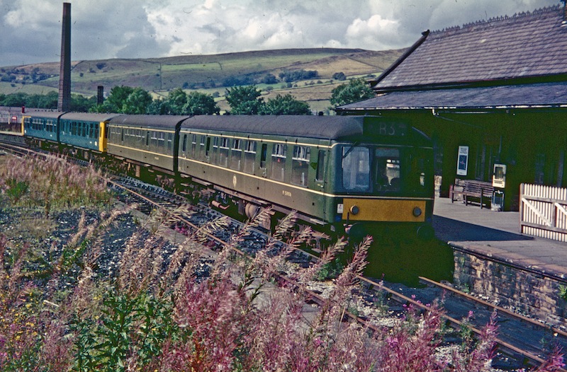
The Hayfield Branch was a single-track branch line that ran along the Sett Valley from the Hope Valley Line near to , via one intermediate stop, . It passed under the town of New Mills through the rock-cut Hayfield tunnel. History Opening The branch opened, in 1868, to serve the villages along the valley of the River Sett and the local mills. It became the joint property of the Manchester, Sheffield & Lincolnshire Railway (later Great Central) and the Midland Railway. It remained a joint station, latterly owned by the London and North Eastern Railway and the London Midland Scottish Railway, until nationalisation of the railways in 1948. Passenger numbers were high especially in the summer months, as the line provided easy access to the countryside. The branch was subsequently assigned to the London Midland Region of British Railways. Introduction of diesel multiple unit (DMU) trains led to an improvement in passenger services and, by the 1960s, there was an hourly ... [...More Info...] [...Related Items...] OR: [Wikipedia] [Google] [Baidu] |
Ollersett
Ollersett is an area of New Mills, Derbyshire, England, about northeast of the town centre, between St. George's Road and High Hill Road. It is about long with about 100 houses, mostly built in the late 1940s. Ollersett Field Ollersett Field is a small field to the north of Ollersett with an area of around . It was the location of the 2006 New Mills carnival fair. There are plans for it to be turned into a football pitch A football pitch (also known as soccer field) is the playing surface for the game of association football. Its dimensions and markings are defined by Law 1 of the Laws of the Game, "The Field of Play". The pitch is typically made of natural t ... for New Mills AFC. To one side of the field runs the Sett Valley Trail. Ollersett Allotments Ollersett Allotments are a set of allotments at one end of Ollersett Field owned by New Mills Town Council, and managed by New Mills Allotment and Gardening Society. They are rented out for £25 per year and postcards ... [...More Info...] [...Related Items...] OR: [Wikipedia] [Google] [Baidu] |


.jpg)
