|
Santirbazar
Santirbazar is a town and Municipal Council in South Tripura district, Tripura, India. It is linked with Agartala (the state capital) by National Highway 8 (India), National Highway 8 via Udaipur, Tripura, Udaipur and Bishramganj to Sabroom. Geography Santirbazar is located at . It has an average elevation of 30 metres (98 feet). Demographics India census, Santirbazar Municipal Council has a population of 15,647. Males constitute 52% of the population and females 48%. Santirbazar has an average literacy rate of 95%, higher than the national average of 59.5%; with 54% of the males and 46% of females literate. 9% of the population is under 6 years of age. Education Schools: * Santir bazar H/S School * Santir bazar Girls H/S School * Bokafa Ashram H/S School * Kendriya Vidyalaya, Bagafa * Sunflower English Medium Academy * Betaga H/S School * West Bokafa H/S School Colleges: * Government Degree College, Santirbazar Places of interest * Pilak, Jolaibari,Tripura, Pil ... [...More Info...] [...Related Items...] OR: [Wikipedia] [Google] [Baidu] |
Government Degree College, Santirbazar
Government Degree College, Santirbazar, established in 2012, is a general degree college in Santirbazar, Tripura. It offers undergraduate courses in arts and sciences. It is affiliated to Tripura University. Department Arts *Bengali *English *Kokborok *History *Political Science *Philosophy *Education Accreditation The college is recognized by the University Grants Commission (India), University Grants Commission (UGC). See also *Education in India *Education in Tripura *Tripura University *Literacy in India *List of institutions of higher education in Tripura References External links *http://www.santirbazarcollege.ac.in/ Colleges affiliated to Tripura University Educational institutions established in 2012 Universities and colleges in Tripura 2012 establishments in Tripura {{tripura-university-stub ... [...More Info...] [...Related Items...] OR: [Wikipedia] [Google] [Baidu] |
Tripura West (Lok Sabha Constituency)
Tripura West Lok Sabha constituency ( bn, ত্রিপুরা পশ্চিম লোকসভা কেন্দ্র) is one of two Lok Sabha constituencies in Tripura state in northeastern India. It includes the state capital Agartala. Assembly segments Tripura West Lok Sabha constituency is composed of the following assembly segments: Members of Parliament Election results General elections 2019 General elections 2014 General elections 2009 General elections 2004 Bye election 2002 A by-election was held in this constituency on 12 November 2002 which was necessitated by the Death of sitting MP Samar Chowdhury. In the by-election, Khagen Das of CPI(M) defeated his nearest rival Manik Deb of Congress by 1,50,843 votes. General elections 1999 See also * List of Constituencies of the Lok Sabha * Tripura East (Lok Sabha constituency) Tripura East is one of the two Lok Sabha cons ... [...More Info...] [...Related Items...] OR: [Wikipedia] [Google] [Baidu] |
South Tripura District
South Tripura ( bn, দক্ষিণ ত্রিপুরা জেলা) is an administrative district in the state of Tripura in northeastern India. History The district came into existence on 1 September 1970, when the entire state was divided into three districts. Geography The district occupies an area of . The district headquarters are located at Belonia. Divisions District has three sub divisions ( Belonia, Sabroom and Santirbazar). The district resides in two Lok Sabha constituencies: Tripura West (shared with West Tripura district) and Tripura East (shared with Dhalai and North Tripura districts. It is also split between seven Legislative assembly constituencies : Belonia, Hrishyamukh, Jolaibari, Manu, Rajnagar, Sabroom and Santirbazar. Demographics According to the 2011 census South Tripura district has a population of 876,001, roughly equal to the nation of Fiji or the US state of Delaware. This gives it a ranking of 471st in India (out of a total of ... [...More Info...] [...Related Items...] OR: [Wikipedia] [Google] [Baidu] |
List Of Cities And Towns In Tripura
Tripura is a state in Northeast India. The third-smallest state in the country, it covers and is bordered by Bangladesh (East Bengal) to the north, south, and west, and the Indian states of Assam and Mizoram to the east. In 2011 the state had 3,671,032 residents, constituting 0.3% of the country's population. Native Tripuri people form about 30 per cent of Tripura's population. The Bengali people form the ethno-linguistic majority in Tripura. The entire work of this article is based on Census of India, conducted by "The Office of the Registrar General and Census Commissioner, India" under Ministry of Home Affairs, Government of India. According to the data from the Census of 2011, there are 8 districts, 23 sub-divisions and 20 municipal towns in the state of Tripura. There is only one city in this state with a Municipal Corporation - Agartala and thirteen towns with Municipal Council as per latest data. References {{reflist External links Census of India website list of Tripu ... [...More Info...] [...Related Items...] OR: [Wikipedia] [Google] [Baidu] |
Kokborok Language
Kokborok (also known as Tripuri or Tiprakok) is the main native language of the Tripuri people of the Indian state of Tripura and neighbouring areas of Bangladesh. Its name comes from ''kok'' meaning "verbal" and ''borok'' meaning "people" or "human" and is one of the ancient languages of Northeast India. History Kokborok was formerly known as Tripuri & Tipra kok, with its name being changed in the 20th century. The names also refer to the inhabitants of the former Twipra kingdom, as well as the ethnicity of its speakers. Kókborok has been attested since at least the 1st century AD, when the historical record of Tripuri kings began to be written down. The script of Kókborok was called "Koloma". The Chronicle of the Tripuri kings were written in a book called the ''Rajratnakar''. This book was originally written down in Kókborok using the Koloma script by Durlobendra Chontai. Later, two Brahmins, Sukreswar and Vaneswar translated it into Sanskrit and then again translated ... [...More Info...] [...Related Items...] OR: [Wikipedia] [Google] [Baidu] |
Tripura
Tripura (, Bengali: ) is a state in Northeast India. The third-smallest state in the country, it covers ; and the seventh-least populous state with a population of 36.71 lakh ( 3.67 million). It is bordered by Assam and Mizoram to the east and by Bangladesh to the north, south and west. Tripura is divided into 8 districts and 23 sub-divisions, where Agartala is the capital and the largest city in the state. Tripura has 19 different tribal communities with a majority of the Bengali population. Bengali, English and Kokborok are the state's official languages. The area of modern Tripura — ruled for several centuries by the Manikya Dynasty — was part of the Tripuri Kingdom (also known as Hill Tippera). It became a princely state under the British Raj during its tenure, and acceded to independent India in 1947. It merged with India in 1949 and was designated as a 'Part C State' ( union territory). It became a full-fledged state of India in 1972. Tripura lies in a geographic ... [...More Info...] [...Related Items...] OR: [Wikipedia] [Google] [Baidu] |
Tripura Map
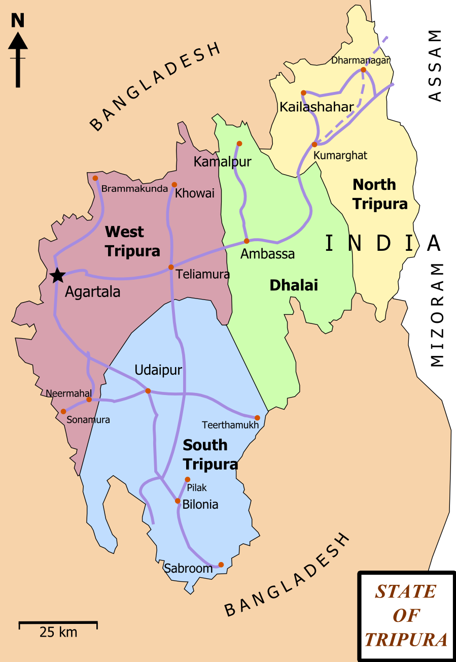
Tripura (, Bengali: ) is a state in Northeast India. The third-smallest state in the country, it covers ; and the seventh-least populous state with a population of 36.71 lakh ( 3.67 million). It is bordered by Assam and Mizoram to the east and by Bangladesh to the north, south and west. Tripura is divided into 8 districts and 23 sub-divisions, where Agartala is the capital and the largest city in the state. Tripura has 19 different tribal communities with a majority of the Bengali population. Bengali, English and Kokborok are the state's official languages. The area of modern Tripura — ruled for several centuries by the Manikya Dynasty — was part of the Tripuri Kingdom (also known as Hill Tippera). It became a princely state under the British Raj during its tenure, and acceded to independent India in 1947. It merged with India in 1949 and was designated as a 'Part C State' ( union territory). It became a full-fledged state of India in 1972. Tripura lies in a geographica ... [...More Info...] [...Related Items...] OR: [Wikipedia] [Google] [Baidu] |
Borders Of India
The Republic of India shares borders with several sovereign countries; it shares land borders with China, Bhutan, Nepal, Pakistan, Bangladesh and Myanmar. Bangladesh and Pakistan share both land borders as well as maritime borders, while Sri Lanka shares only a maritime border through Adam's Bridge. India's Andaman and Nicobar Islands share a maritime border with Thailand, Myanmar and Indonesia. Land borders of India India shares land borders with seven sovereign nations. The state's Ministry of Home Affairs also recognizes a land border with an eighth nation, Afghanistan, as part of its claim of the Kashmir region (see Durand Line). Maritime borders of India Maritime borders of India are the maritime boundary recognized by the United Nations Convention on the Law of the Sea entails boundaries of territorial waters, contiguous zones, and exclusive economic zones. India, with its claim of a territorial maritime zone and exclusive economic zone, has a more than ma ... [...More Info...] [...Related Items...] OR: [Wikipedia] [Google] [Baidu] |
Trishna Wildlife Sanctuary
Trishna Wildlife Sanctuary is a wildlife sanctuary in Tripura, India. It was founded in 1988. The sanctuary is situated in South Tripura District. It is from the sub divisional town of Belonia and is connected with Agartala by state highway. It can be approached either from Belonia in the south or Sonamura in the north. The sanctuary covers an area of 163 square kilometers. It has a number of perennial water rivulets, water bodies and grass land. There are patches of virgin forests which are rich in rare vegetation. Indian gaur (bison) is an attraction of the sanctuary. There are also varieties of birds, deer, hoolock gibbon, golden langur, capped langur, pheasant Pheasants ( ) are birds of several genera within the family (biology), family Phasianidae in the order (biology), order Galliformes. Although they can be found all over the world in introduced (and captive) populations, the pheasant genera na ... and many other animals and reptiles. References External linksT ... [...More Info...] [...Related Items...] OR: [Wikipedia] [Google] [Baidu] |
Literacy
Literacy in its broadest sense describes "particular ways of thinking about and doing reading and writing" with the purpose of understanding or expressing thoughts or ideas in written form in some specific context of use. In other words, humans in literate societies have sets of practices for producing and consuming writing, and they also have beliefs about these practices. Reading, in this view, is always reading something for some purpose; writing is always writing something for someone for some particular ends. Beliefs about reading and writing and its value for society and for the individual always influence the ways literacy is taught, learned, and practiced over the lifespan. Some researchers suggest that the history of interest in the concept of "literacy" can be divided into two periods. Firstly is the period before 1950, when literacy was understood solely as alphabetical literacy (word and letter recognition). Secondly is the period after 1950, when literacy slowly ... [...More Info...] [...Related Items...] OR: [Wikipedia] [Google] [Baidu] |
Muhuri River
Muhuri is a transnational river between India and Bangladesh. Rising in Tripura, it flows into Bangladesh where it merges with the Feni near the latter's mouth to the Bay of Bengal. The Muhuri is also known as the Little Feni. Course of the river The Muhuri rises in the Lushai Hills of Tripura and flows west into Bangladesh which it enters through the Parshuram upazila of Feni district. In Bangladesh, the river separates the Feni and Chittagong districts before flowing out into the Bay of Bengal. Indo-Bangladesh border The Muhuri acts as the border between India and Bangladesh in the Tripura-Noakhali sector. However, the frequently changing course of the river prevented the two nations from demarcating the boundary here with India insisting on the 1974 Accord with Bangladesh that calls for demarcation "along the mid-stream of the course of Muhuri river at the time of demarcation" while Bangladesh insisted on an 1893 map that would result in it gaining an extra 44 acres f ... [...More Info...] [...Related Items...] OR: [Wikipedia] [Google] [Baidu] |


