|
Retezat Mountains
The Retezat Mountains ( ro, Munții Retezat, hu, Retyezát-hegység) are one of the highest massifs in Romania, being part of the Southern Carpathians. The highest peak is Peleaga (Vârful Peleaga), at an altitude of . Other important peaks are Păpușa (Vârful Păpușa, "the Doll Peak") and Retezat Peak (Vârful Retezat). The name means "cut off" in Romanian. Geography The Retezat Mountains have many glacial lakes, including the largest glacial lake in Romania, Bucura Lake (Lacul Bucura), which covers and is situated at an altitude of . The area also contains the Retezat National Park, Romania's first national park. River systems and lakes The tectonic, lithologic and morphologic conditions present in the Retezat Mountains, correlated with the orientation of the ridges towards the main air masses make this mountain group the most humid area in the Romanian Carpathians. The hydrologic network is divided into two main directions: north, towards the river Strei (the Mur ... [...More Info...] [...Related Items...] OR: [Wikipedia] [Google] [Baidu] |
Southern Carpathians
The Southern Carpathians (also known as the Transylvanian Alps; ro, Carpații Meridionali ; hu, Déli-Kárpátok) are a group of mountain ranges located in southern Romania. They cover the part of the Carpathian Mountains located between the Prahova River in the east and the Timiș and Cerna Rivers in the west. To the south they are bounded by the Balkan mountain range in eastern Serbia. Heights The Southern Carpathians are the second highest group of mountains in the Carpathian Mountain range (after Tatra), reaching heights of over 2,500 meters. Although considerably smaller than the Alps, they are classified as having an alpine landscape. Their high mountain character, combined with great accessibility, makes them popular with tourists and scientists. The highest peaks are: * Moldoveanu Peak, 2,544 metres – Făgăraș Mountains * Negoiu, 2,535 metres – Făgăraș Mountains * Parângu Mare, 2,519 metres – Parâng Mountains * Omu Peak 2,514 metres – Bucegi Mounta ... [...More Info...] [...Related Items...] OR: [Wikipedia] [Google] [Baidu] |
Romanian Carpathians
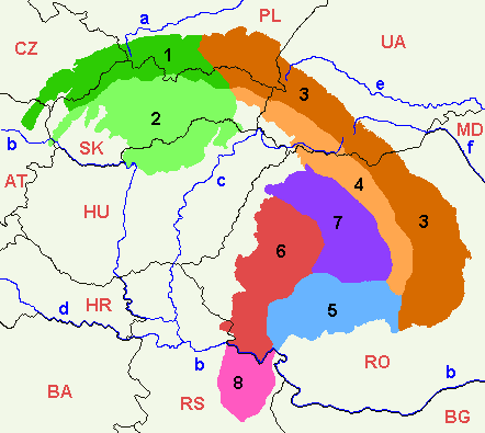
The Romanian Carpathians ( ro, Carpații românești) are a section of the Carpathian Mountains, within the borders of modern Romania. The Carpathians are a "subsystem" of the Alps-Himalaya System and are further divided into "provinces" and "subprovinces". This is an overview of the geological subdivisions of the Romanian section of the Carpathian Mountains. The broadest divisions are shown in the map on the right. The last level of the division, i.e. the actual mountain ranges and basins, is usually called "units". The lowest-level detail for those units is maintained on separate pages. Naming conventions Traditional Romanian naming conventions differ from this list. In Romania, it is usual to divide the Eastern Carpathians in Romanian territory into three geographical groups (North, Centre, South), instead in Outer and Inner Eastern Carpathians. The Transylvanian Plateau is encircled by, and geologically a part of, the Carpathians, but it is not a mountainous region and ... [...More Info...] [...Related Items...] OR: [Wikipedia] [Google] [Baidu] |
Zănoaga Lake
{{geodis ...
Zănoaga may refer to several villages in Romania: * Zănoaga, a village in Leu Commune, Dolj County * Zănoaga, a village in Dăneasa Commune, Olt County * Zănoaga, a village in Dumbrava Commune, Prahova County Prahova County () is a county ( județ) of Romania, in the historical region Muntenia, with the capital city at Ploiești. Demographics In 2011, it had a population of 762,886 and the population density was 161/km². It is Romania's third mos ... [...More Info...] [...Related Items...] OR: [Wikipedia] [Google] [Baidu] |
Caldera
A caldera ( ) is a large cauldron-like hollow that forms shortly after the emptying of a magma chamber in a volcano eruption. When large volumes of magma are erupted over a short time, structural support for the rock above the magma chamber is gone. The ground surface then collapses into the emptied or partially emptied magma chamber, leaving a large depression at the surface (from one to dozens of kilometers in diameter). Although sometimes described as a Volcanic crater, crater, the feature is actually a type of sinkhole, as it is formed through subsidence and collapse rather than an explosion or impact. Compared to the thousands of volcanic eruptions that occur each century, the formation of a caldera is a rare event, occurring only a few times per century. Only seven caldera-forming collapses are known to have occurred between 1911 and 2016. More recently, a caldera collapse occurred at Kīlauea, Hawaii in 2018. Etymology The term ''caldera'' comes from Spanish language, S ... [...More Info...] [...Related Items...] OR: [Wikipedia] [Google] [Baidu] |
Waterfall
A waterfall is a point in a river or stream where water flows over a vertical drop or a series of steep drops. Waterfalls also occur where meltwater drops over the edge of a tabular iceberg or ice shelf. Waterfalls can be formed in several ways, but the most common method of formation is that a river courses over a top layer of resistant bedrock before falling on to softer rock, which Erosion, erodes faster, leading to an increasingly high fall. Waterfalls have been studied for their impact on species living in and around them. Humans have had a distinct relationship with waterfalls for years, travelling to see them, exploring and naming them. They can present formidable barriers to navigation along rivers. Waterfalls are religious sites in many cultures. Since the 18th century they have received increased attention as tourist destinations, sources of hydropower, andparticularly since the mid-20th centuryas subjects of research. Definition and terminology A waterfall is gen ... [...More Info...] [...Related Items...] OR: [Wikipedia] [Google] [Baidu] |
Râul Mare (Strei)
The Râul Mare (upstream from its confluence with the Șes also: ''Lăpușnic'') is a left tributary of the river Strei in Romania. It discharges into the Strei in Subcetate. e-calauza.ro Its source is in the Retezat Mountains
The Retezat Mountains ( ro, Munții Retezat, hu, Retyezát-hegység) are one of the highest massifs in Romania, being part of the Southern Carpathians. The highest peak is Peleaga (Vârful Peleaga), at an altitude of . Other important peaks are ... . It flows through the reservoirs Gura Apelor, Ostrovul Mic, ...
[...More Info...] [...Related Items...] OR: [Wikipedia] [Google] [Baidu] |
Jiu (river)
The Jiu (; hu, Zsil ; german: Schil or Schiel; la, Rabon) is a river in southern Romania. It is formed near Petroșani by the confluence of headwaters Jiul de Vest and Jiul de Est. It flows southward through the Romanian counties Hunedoara County, Hunedoara, Gorj County, Gorj and Dolj County, Dolj before flowing into the Danube near Zăval, a few kilometers upstream from the Bulgarian city of Oryahovo. It is long, including its source river Jiul de Vest. It has a basin of . p. 13 Its average discharge (hydrology), discharge at the River mouth, mouth is . The upper Jiu Valley, around Petroșani and Lupeni, is Romania's principal coal mining region. Towns and cities The following towns are situated along the river ...[...More Info...] [...Related Items...] OR: [Wikipedia] [Google] [Baidu] |
Jiul De Vest
The Jiul de Vest ("Western Jiu", previously also known as ) is a headwater of the river Jiu in Romania. At its confluence with the Jiul de Est in Iscroni, the Jiu is formed. e-calauza.ro Its length is and its basin size is . The upper course of the river is also known locally as . simply means "the Jiu", appended by the definite article . Tributaries The following rivers are tributaries to the river Jiul de Vest (from source to mouth): *Left: Iarului, Scorota, Scocu Urzicaru, Pleșa, Buta, Lazăr, Valea Ursească, Toplița, Pilug, Valea de Brazi, Furu, Valea Șerpilor, Sterminos, Mierleasa, |
Massif
In geology, a massif ( or ) is a section of a planet's crust that is demarcated by faults or flexures. In the movement of the crust, a massif tends to retain its internal structure while being displaced as a whole. The term also refers to a group of mountains formed by such a structure. In mountaineering and climbing literature, a massif is frequently used to denote the main mass of an individual mountain. The massif is a smaller structural unit of the crust than a tectonic plate, and is considered the fourth-largest driving force in geomorphology. The word is taken from French (in which the word also means "massive"), where it is used to refer a large mountain mass or compact group of connected mountains forming an independent portion of a range. One of the most notable European examples of a massif is the Massif Central of the Auvergne region of France. The Face on Mars is an example of an extraterrestrial massif. Massifs may also form underwater, as with the Atlanti ... [...More Info...] [...Related Items...] OR: [Wikipedia] [Google] [Baidu] |
Drainage Basin
A drainage basin is an area of land where all flowing surface water converges to a single point, such as a river mouth, or flows into another body of water, such as a lake or ocean. A basin is separated from adjacent basins by a perimeter, the '' drainage divide'', made up of a succession of elevated features, such as ridges and hills. A basin may consist of smaller basins that merge at river confluences, forming a hierarchical pattern. Other terms for a drainage basin are catchment area, catchment basin, drainage area, river basin, water basin, and impluvium. In North America, they are commonly called a watershed, though in other English-speaking places, "watershed" is used only in its original sense, that of a drainage divide. In a closed drainage basin, or endorheic basin, the water converges to a single point inside the basin, known as a sink, which may be a permanent lake, a dry lake, or a point where surface water is lost underground. Drainage basins are similar ... [...More Info...] [...Related Items...] OR: [Wikipedia] [Google] [Baidu] |


