|
Ratna Highway
Ratna Highway ( ne, रत्न राजमार्ग , also referred to as H12) is a highway in western Nepal that crosses the districts of Banke and Surkhet in a south to north direction. The 113.08 km highway starts at Nepalgunj, where it depicts a continuation of National Highway 927 of India and runs towards the North, where it crosses Mahendra Highway at Kohalpur. The highway continues north and leave the Terai Plains, crosses Babai River and terminates in Birendranagar, from where Karnali Highway Karnali Highway ( ne, कर्णाली राजमार्ग, also referred to as H13) is a highway, and is a vital transport link between two regions in Nepal. This highway links the towns of Jumla with the Karnali capital Birendranaga ... continues northwards. References {{Highways in Nepal Roads in Nepal ... [...More Info...] [...Related Items...] OR: [Wikipedia] [Google] [Baidu] |
Kohalpur
Kohalpur ( ne, कोहलपुर) is a municipality in Banke District of Lumbini province of Nepal. The municipality was established on 18 May 2014 merging the existing two Village Development Committees i.e. Rajhena and Kohalpur. The town is in East-West highway and one of the fastest developing places in Nepal. A neighboring city Nepalgunj is on South (), with Ghorahi city () to west in Dang District, Nepal, Dang District and further is the Indian border. In fact it is a growing city in the western region of Nepal. It has a junction to diverse the roadway transport to east, west, north and south from the city. It is accessible by air (Nepalgunj Airport) and by road ( west of Kathmandu). Kohalpur Municipality Kohalpur is second municipality in the Banke District, with the first being Nepalgunj. As a municipality, Kohalpur will assume greater local government autonomy and greater financial resources as part of the central governments' effort to promote decentralized pow ... [...More Info...] [...Related Items...] OR: [Wikipedia] [Google] [Baidu] |
Birendranagar
Birendranagar ( ne, वीरेन्द्रनगर) officially Birendranagar Municipality is a city in Surkhet District in Karnali Province of Nepal. It is the district headquarter of Surkhet District and also the capital city of Karnali province. As of March 2022, Birendranagar has a population of 154,886 making it the 17th largest city of Nepal. It is the largest city of karnali province and 7th largest in Western Nepal. It is one of the fastest growing cities of Nepal. Birendranagar is the destination of two national highways i.e Ratna Highway and Karnali Highway. It is one of the constituent city of Ratna Highway Metropolitan Areas along with Nepalgunj and Kohalpur. Birendranagar is compromise of panoramic view of Mahabharata and chure ranges and the plain of inner terai . Birendranagar is a major trade center in mid-western Nepal and is considered as the most expensive city to live in Nepal. In February 2018, the city was made the capital of the province of Karnali. ... [...More Info...] [...Related Items...] OR: [Wikipedia] [Google] [Baidu] |
Nepal
Nepal (; ne, नेपाल ), formerly the Federal Democratic Republic of Nepal ( ne, सङ्घीय लोकतान्त्रिक गणतन्त्र नेपाल ), is a landlocked country in South Asia. It is mainly situated in the Himalayas, but also includes parts of the Indo-Gangetic Plain, bordering the Tibet Autonomous Region of China to the north, and India in the south, east, and west, while it is narrowly separated from Bangladesh by the Siliguri Corridor, and from Bhutan by the Indian state of Sikkim. Nepal has a diverse geography, including fertile plains, subalpine forested hills, and eight of the world's ten tallest mountains, including Mount Everest, the highest point on Earth. Nepal is a multi-ethnic, multi-lingual, multi-religious and multi-cultural state, with Nepali as the official language. Kathmandu is the nation's capital and the largest city. The name "Nepal" is first recorded in texts from the Vedic period of the India ... [...More Info...] [...Related Items...] OR: [Wikipedia] [Google] [Baidu] |
Nepalganj
Nepalgunj (), also spelled Nepalganj, is a Sub-Metropolitan City in Banke District, Nepal. It lies on the Terai plains near the southern border with Bahraich district in Uttar Pradesh, India. Nepalgunj is 153 kilometers south-west of Ghorahi and 16 km south of Kohalpur. Former Village Development Committee: Udayapur, Bhawaniyapur, Piprahawa, Jaispur, Paraspur, Indrapur, Khaskarkado, Bashudevpur, Manikapur and Puraina were added to territory in order to make it Sub metropolitan city on 2071 Paush 28 and later Puraini was also added in list on 2072 Paush 21. Further, while restructuring of local levels nationwide, ward no. 23 (former Indrapur VDC) was taken out to Janaki Rural Municipality and ward no. 7 of Hirminiya VDC was added to Nepalgunj. Demographics The 2011 census counted 73,779 inhabitants with 20% growth since 2001. Currently it is estimated around 1,60,000 inhabitants in Nepalgunj city. Culture and religion Nepalgunj has a diverse culture with peop ... [...More Info...] [...Related Items...] OR: [Wikipedia] [Google] [Baidu] |
Banke District
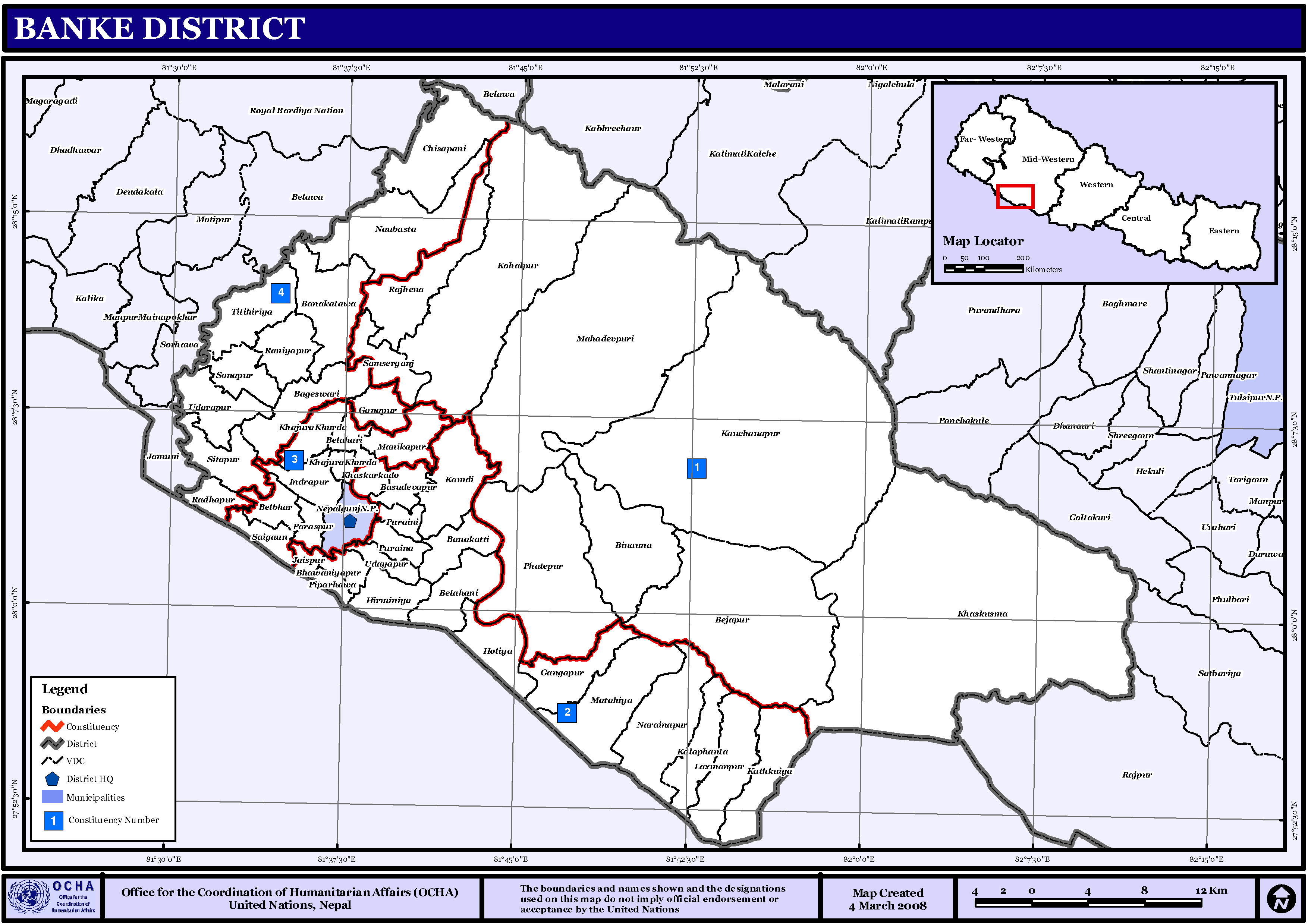
Banke District ( ne, बाँके जिल्ला , a part of Lumbini Province, is one of the 77 districts of Nepal. The district, located in midwestern Nepal with Nepalganj as its district headquarters, covers an area of and had a population of 385,840 in 2001 and 491,313 in 2011. There are three main cities in the Banke District: Nepalganj, Kohalpur and Khajura Bajaar. Geography and Climate Banke is bordered on the west by ''Bardiya district''. ''Rapti zone's'' ''Salyan'' and ''Dang Deukhuri Districts'' border to the north and east. To the south lies ''Uttar Pradesh'', India, a country in Asia; specifically ''Shravasti'' and ''Bahraich districts'' of ''Awadh''. East of Nepalganj the international border follows the southern edge of the ''Dudhwa Range'' of the ''Siwaliks''. Most of the district is drained by the ''Rapti'', except the district's western edge is drained by the ''Babai''. Rapti and Babai cross into Uttar Pradesh, a state in India, Nepal's neighboring c ... [...More Info...] [...Related Items...] OR: [Wikipedia] [Google] [Baidu] |
Surkhet District
Surkhet District ( ne, सुर्खेत जिल्ला, ) is a district in Karnali Province of mid-western Nepal. Surkhet is the one of the ten Districts of Nepal, districts of Karnali located about west of the national capital Kathmandu. The district's area is . It had 288,527 population in 2001 and 350,804 in 2011 which male comprised 169,461 and female 181,381. Its district headquarters, Birendranagar, is the capital of Karnali Province. It is serving as a business hub and document center for Karnali province. According to population, development, road links, landforms, climate, many peoples are migrating here. after becoming province capital developmental activities are boosted and are in peak level. all the governmental works are carried here. Birendranagar is beautiful valley surrounded by hills having moderate climate. Geography and Climate Surkhet Valley is one of the Inner Terai Valleys of Nepal. It borders, Achham District, Achham district of Sudurpashchim Provi ... [...More Info...] [...Related Items...] OR: [Wikipedia] [Google] [Baidu] |
Nepalgunj
Nepalgunj (), also spelled Nepalganj, is a Sub-Metropolitan City in Banke District, Nepal. It lies on the Terai plains near the southern border with Bahraich district in Uttar Pradesh, India. Nepalgunj is 153 kilometers south-west of Ghorahi and 16 km south of Kohalpur. Former Village Development Committee: Udayapur, Bhawaniyapur, Piprahawa, Jaispur, Paraspur, Indrapur, Khaskarkado, Bashudevpur, Manikapur and Puraina were added to territory in order to make it Sub metropolitan city on 2071 Paush 28 and later Puraini was also added in list on 2072 Paush 21. Further, while restructuring of local levels nationwide, ward no. 23 (former Indrapur VDC) was taken out to Janaki Rural Municipality and ward no. 7 of Hirminiya VDC was added to Nepalgunj. Demographics The 2011 census counted 73,779 inhabitants with 20% growth since 2001. Currently it is estimated around 1,60,000 inhabitants in Nepalgunj city. Culture and religion Nepalgunj has a diverse culture with peo ... [...More Info...] [...Related Items...] OR: [Wikipedia] [Google] [Baidu] |
National Highway 927 (India)
National Highway 927 (NH 927) is a National Highway in India India, officially the Republic of India (Hindi: ), is a country in South Asia. It is the seventh-largest country by area, the second-most populous country, and the most populous democracy in the world. Bounded by the Indian Ocean on the so .... References National highways in India Transport in Barabanki, Uttar Pradesh Transport in Nepal {{India-NH-stub ... [...More Info...] [...Related Items...] OR: [Wikipedia] [Google] [Baidu] |
Mahendra Highway
Mahendra Highway (), also called East-West Highway () runs across the Terai geographical region of Nepal, from Mechinagar in the east to Bhim Datta in the west, cutting across the entire width of the country. It is the longest highway in Nepal and was constructed by cooperation of various countries. Overview The highway is mostly a single lane in each direction. It is a major infrastructure element because east–west travel was previously limited to the Hulaki Highway built during the Rana regime, expensive and limited air travel, or Nepalese trains and buses. The highway crosses the Terai from east to west for over . Connecting Nepal from Kakarbhitta (Mechinagar Municipality) to West Mahendra Nagar in the east, this is the longest highway in Nepal till now. Bharatpur city and Chitwan valley are located towards the central part of this highway. The major destinations along and around the highway are Mechinagar, Bhadrapur, Itahari, Janakpur, Bharatpur, Butwal, Siddharthanag ... [...More Info...] [...Related Items...] OR: [Wikipedia] [Google] [Baidu] |
Terai
The Terai or Tarai is a lowland region in northern India and southern Nepal that lies south of the outer foothills of the Himalayas, the Sivalik Hills, and north of the Indo-Gangetic Plain. This lowland belt is characterised by tall grasslands, scrub savannah, Shorea robusta, sal forests and clay rich swamps. In North India, the Terai spreads from the Yamuna River eastward across Haryana, Uttarakhand, Uttar Pradesh, Bihar and West Bengal. The Terai is part of the Terai-Duar savanna and grasslands ecoregion. The corresponding lowland region in West Bengal, Bangladesh, Bhutan and Assam in the Brahmaputra River basin is called 'Dooars'. In Nepal, the term is applied to the part of the country situated north of the Indo-Gangetic Plain. Nepal's Terai stretches over , about 23.1% of Nepal's land area, and lies at an elevation of between . The region comprises more than 50 wetlands. North of the Terai rises the Bhabar, a narrow but continuous belt of forest about wide. Etymology The Urdu ... [...More Info...] [...Related Items...] OR: [Wikipedia] [Google] [Baidu] |
Babai River
The Babai River ( ne, बबई नदी) originates in and completely drains Inner Terai Dang Valley of Mid-Western Nepal. Dang is an oval valley between the Mahabharat Range and Siwalik Hills in its eponymous district. Dang was anciently home to indigenous Tharu people and came to be ruled from India by the House of Tulsipur who also counted as one of the Baise Rajya ( ne, बाइसे राज्य)—a confederation of 22 petty kingdoms in the Karnali (Ghagra) region. About 1760 AD all these kingdoms were annexed by the Shah Dynasty during the unification of Nepal, except Tulsipur lands south of the Siwalik Hills were not taken. Since Dang Valley was somewhat higher, cooler, better-drained and therefore less malarial than most of the country's Inner Terai, it was settled to some extent by Shah and Rana courtiers and other Paharis long before DDT was introduced to control the disease-bearing ''Anopheles'' mosquito. Exiting Dang Valley and its district, the ... [...More Info...] [...Related Items...] OR: [Wikipedia] [Google] [Baidu] |
Karnali Highway
Karnali Highway ( ne, कर्णाली राजमार्ग, also referred to as H13) is a highway, and is a vital transport link between two regions in Nepal. This highway links the towns of Jumla with the Karnali capital Birendranagar and rest parts of Surkhet district. Karnali Province is the largest, remotest and the least developed province in Nepal. Of its length, were blacktopped in 2010, previously the unfinished highway journey was featured in a documentary ''The Karnali Express: Bumping on for 52 Hours'' Due to heavy monsoon rains in 2010, the Karnali Highway was closed due to landslides from heavy monsoon rains, crops were destroyed by incessant rain, and 1/3 of the entire country was inaccessible except by foot. It was finally reopened October 3, three months later, but not until after starvation deaths. According to “A Value Chain Analysis of Apple from Jumla”, and the intervention strategy indicates that more than 85 percent of the Karnali hi ... [...More Info...] [...Related Items...] OR: [Wikipedia] [Google] [Baidu] |


