|
Ramsden Square
Ramsden Square is a square located at the intersection of Abbey Road and Duke Street in Barrow-in-Furness, Cumbria, England. It marks the boundary of the Central and Hindpool wards and now acts as a major roundabout. Ramsden Square was first laid out in the 1840s to act as a focal point of Sir James Ramsden's master plan for the new town of Barrow, separating its burgeoning industries and commercial core. The centerpiece of the square is a statue of Ramsden himself while it is framed by a number of historic buildings including Barrow Central Library, the National Westminster Bank Building and formerly the Barrow Jute Works. See also * Schneider Square Schneider Square is a square located at the intersection of Duke Street, Dalton Road, Michaelson Road, Burlington Street and Fisher's Yard in Barrow-in-Furness, Cumbria, England. Schneider Square has changed little since its construction in the ... * St. George's Square References {{Coord, 54.114, -3.231, display=title ... [...More Info...] [...Related Items...] OR: [Wikipedia] [Google] [Baidu] |
Abbey Road, Barrow-in-Furness
Abbey Road is the principal north to south arterial road through Barrow-in-Furness, Cumbria, England. Background Abbey Road's name derives from Furness Abbey, a former Cistercian monastery along the route of the road. Beginning at Market Street, in the centre of Dalton-in-Furness, the road runs south and terminates at Hindpool Road, close to the centre of Barrow where the A590 and A5087 merge. Abbey Road predates Barrow itself although it was substantially upgraded to its current appearance during the mid-19th century, when the town was undergoing dramatic growth. The of Abbey Road that runs through Barrow is a tree-lined boulevard with multiple lanes, while the northern section of the road beyond Mill Brow is single lane, winding and more rural in nature. Sites along Abbey Road include Dalton town centre, Furness General Hospital, Barrow Park, Barrow-in-Furness railway station, Barrow town centre and several of Barrow's retail parks. Until 1932, the Barrow-in-Furness Tram ... [...More Info...] [...Related Items...] OR: [Wikipedia] [Google] [Baidu] |
Duke Street, Barrow-in-Furness
Duke Street is a road running through the town centre and Hindpool area of Barrow-in-Furness, England. Stretching almost one mile from east to west it connects two major A roads as well as intersecting Abbey Road roughly midway. Designed by Sir James Ramsden as the centrepiece of the 19th century planned town of Barrow, Duke Street is home to three squares ( Ramsden Square, Town Square and Schneider Square) alongside many listed buildings including Barrow Town Hall and the Main Public Library. The Forum performing arts centre and Craven Park Stadium (home of the rugby league side Barrow Raiders) are also located on Duke Street. Listed buildings The list below includes all listed buildings located on Duke Street. * 4 Duke Street, Duke Street Surgery (Grade II) * 63, 65 and 67 Duke Street (Grade II) * 77 and 79 Duke Street (Grade II) * 81, 83, 85, 87 and 89 Duke Street (Grade II) * 92, 94 and 96 Duke Street, Barclays Bank (Grade II) * 101, 103, 105, 107 and 109 Duke Street ... [...More Info...] [...Related Items...] OR: [Wikipedia] [Google] [Baidu] |
Barrow-in-Furness
Barrow-in-Furness is a port town in Cumbria, England. Historically in Lancashire, it was incorporated as a municipal borough in 1867 and merged with Dalton-in-Furness Urban District in 1974 to form the Borough of Barrow-in-Furness. In 2023 the borough will merge with Eden and South Lakeland districts to form a new unitary authority; Westmorland and Furness. At the tip of the Furness peninsula, close to the Lake District, it is bordered by Morecambe Bay, the Duddon Estuary and the Irish Sea. In 2011, Barrow's population was 56,745, making it the second largest urban area in Cumbria after Carlisle. Natives of Barrow, as well as the local dialect, are known as Barrovian. In the Middle Ages, Barrow was a small hamlet within the parish of Dalton-in-Furness with Furness Abbey, now on the outskirts of the town, controlling the local economy before its dissolution in 1537. The iron prospector Henry Schneider arrived in Furness in 1839 and, with other investors, opened the Furness Railwa ... [...More Info...] [...Related Items...] OR: [Wikipedia] [Google] [Baidu] |
Cumbria
Cumbria ( ) is a ceremonial and non-metropolitan county in North West England, bordering Scotland. The county and Cumbria County Council, its local government, came into existence in 1974 after the passage of the Local Government Act 1972. Cumbria's county town is Carlisle, in the north of the county. Other major settlements include Barrow-in-Furness, Kendal, Whitehaven and Workington. The administrative county of Cumbria consists of six districts ( Allerdale, Barrow-in-Furness, Carlisle, Copeland, Eden and South Lakeland) and, in 2019, had a population of 500,012. Cumbria is one of the most sparsely populated counties in England, with 73.4 people per km2 (190/sq mi). On 1 April 2023, the administrative county of Cumbria will be abolished and replaced with two new unitary authorities: Westmorland and Furness (Barrow-in-Furness, Eden, South Lakeland) and Cumberland ( Allerdale, Carlisle, Copeland). Cumbria is the third largest ceremonial county in England by area. It i ... [...More Info...] [...Related Items...] OR: [Wikipedia] [Google] [Baidu] |
Central Barrow
Central Barrow refers both to the town centre of Barrow-in-Furness, Cumbria, England and to the electoral ward that roughly covers the eastern part of that town centre. In 2001 5,584 ( ranking 5th out of 13) lived in the Central ward. The population density was 55.96 per hectare, which was well above the local average of 9.24, and England average, 3.77. The population of Central ward had reduced to 4,583 at the 2011 Census. Central Barrow is amongst the 3% most deprived areas in the country and households have an average weekly income around £100 lower than the region's average, however the area being the central business district of the town is also home to many of Barrow's retail outlets, as well as a large amount of offices, restaurants and governmental buildings. Part of the £200 million Waterfront Barrow-in-Furness project is being constructed in the southern part of Central Barrow (including the new Marina Village). The ward itself will be combined with Barrow Island an ... [...More Info...] [...Related Items...] OR: [Wikipedia] [Google] [Baidu] |
Hindpool
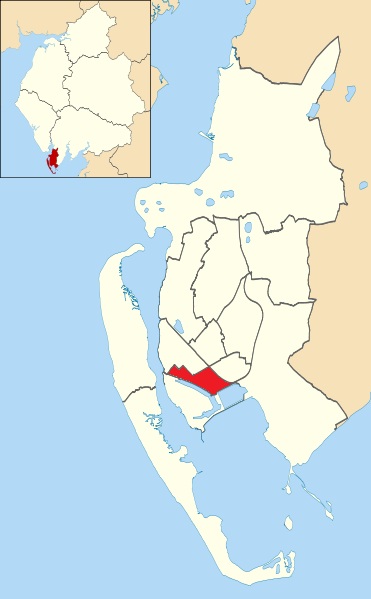
Hindpool is an area and Wards of the United Kingdom, electoral ward of Barrow-in-Furness, Cumbria, England. It is bordered by Barrow Island, Barrow-in-Furness, Barrow Island, Central Barrow, Ormsgill, Parkside, Barrow-in-Furness, Parkside and the Walney Channel, the local population stood at 5,851 in 2011. The ward covers the entire western half of the town centre and includes Barrow's main List of leading shopping streets and districts by city, shopping district. Other local landmarks include the Furness College, Barrow-in-Furness, Furness College Channelside campus, the Dock Museum and the Barrow-in-Furness Main Public Library, Main Public Library. Hindpool is also home to two stadia - Barrow Raiders' Craven Park (Barrow), Craven Park and Barrow A.F.C.'s Holker Street. The ward itself will be combined with Barrow Island and Central wards in April 2023 following formation of the new Westmorland and Furness Local Authority and be named 'Old Barrow'. History The Hindpool Estate ap ... [...More Info...] [...Related Items...] OR: [Wikipedia] [Google] [Baidu] |
Roundabout
A roundabout is a type of circular intersection or junction in which road traffic is permitted to flow in one direction around a central island, and priority is typically given to traffic already in the junction.''The New Shorter Oxford English Dictionary,'' Volume 2, Clarendon Press, Oxford (1993), page 2632 Engineers use the term modern roundabout to refer to junctions installed after 1960 that incorporate various design rules to increase safety. Both modern and non-modern roundabouts, however, may bear street names or be identified colloquially by local names such as rotary or traffic circle. Compared to stop signs, traffic signals, and earlier forms of roundabouts, modern roundabouts reduce the likelihood and severity of collisions greatly by reducing traffic speeds and minimizing T-bone and head-on collisions. Variations on the basic concept include integration with tram or train lines, two-way flow, higher speeds and many others. For pedestrians, traffic exiting th ... [...More Info...] [...Related Items...] OR: [Wikipedia] [Google] [Baidu] |
Sir James Ramsden
Sir James Ramsden (25 February 1822 – 19 October 1896) was a British mechanical engineer, industrialist, and civic leader, who played a dominant role in the development of the new town of Barrow-in-Furness, in the historic county of Lancashire. He served five successive terms as mayor on its first achieving municipal borough status, from 1867 onwards. Biography James Ramsden was most probably born at Bolton, Lancashire (although the census records are inconsistent on this point). James Ramsden was one of several children of William Ramsden, an engineer. He served an apprenticeship with the Liverpool firm of Bury, Curtis, and Kennedy before becoming locomotive superintendent for the new Furness Railway Company in January 1846. He very soon rose to become company secretary, and later served as managing director between 1866 and 1895. In 1866, Ramsden was also appointed managing director of the '' Barrow Hematite Steel Company, Limited'', and from 1875 to 1888 took th ... [...More Info...] [...Related Items...] OR: [Wikipedia] [Google] [Baidu] |
Barrow-in-Furness Main Public Library
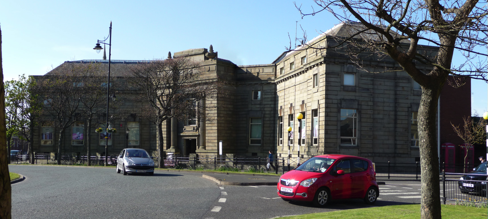
Barrow-in-Furness Main Public Library (more usually known as Barrow Central Library or Barrow Library) is a Grade II listed Beaux-Arts style building located at Ramsden Square, Barrow-in-Furness, England. Operated since 1974 by Cumbria County Council, it is the largest library in the town and the present structure, designed by J A Charles was originally built as a Carnegie library with support from the Carnegie Foundation. The first library in Barrow was opened on 18 September 1882 in temporary iron buildings in Schneider Square; in 1887 this was transferred to a room within Barrow Town Hall.F Barnes, Barrow and District, page 115, reprinted 1979, published by Barrow Borough Council, no ISBN The growing population meant that a larger building was needed and this was eventually met by the construction of the present accommodation at the junction of Abbey Road with Ramsden Square. The building itself bears a date of 1915 (denoted by an engraving by the main entrance which reads ... [...More Info...] [...Related Items...] OR: [Wikipedia] [Google] [Baidu] |
National Westminster Bank, Barrow-in-Furness
The National Westminster Bank building in Barrow-in-Furness, Cumbria, England is located at the intersection of Abbey Road, Barrow-in-Furness, Abbey Road and Duke Street, Barrow-in-Furness, Duke Street. It was designed by Sharpe, Paley and Austin#Paley and Austin, Paley and Austin architects and built between 1873–74 and has been designated a Listed building, Grade II listed building by English Heritage. Built for the Lancaster branch of the National Westminster Bank it was a major component of the Ramsden Square scheme, one of the planned town's two main squares and focal points. It is one of three former 'Nat West' properties with listed building status in the Borough and currently houses a carpet shop in the lower floors. See also * Listed buildings in Barrow-in-Furness References {{coord, 54.1140, -3.2308, format=dms, type:landmark, display=title Buildings and structures in Barrow-in-Furness, National Westminster Bank Grade II listed banks Grade II listed buildings in ... [...More Info...] [...Related Items...] OR: [Wikipedia] [Google] [Baidu] |
Barrow Jute Works
The Barrow Jute Works was a jute and flax mill located in Barrow-in-Furness, Lancashire (now Cumbria), England during the late 19th and early 20th centuries. The mill was built for the ''Barrow and Calcutta Jute Company'' which was founded by James Ramsden in 1870 in an attempt to diversify Barrow's economy which was heavily focused on iron and steel production. The Jute Works itself was designed by architects Paley and Austin and occupied over 12-acres with a facade on Hindpool Road and along Abbey Road. The mill was served by its own railway station on a branch of the Furness Railway which connected it to the town's docks, steelworks and cornmill. The mill's all female workforce peaked at 2,000, many of whom were Irish immigrants. The jute fabrics produced were used for a wide range of items including telegraph cables, ropes and artificial hair, later including the production of Kalemeit for carpets, rugs and window drapery. The quality of produce was acknowledged in 1878 at ... [...More Info...] [...Related Items...] OR: [Wikipedia] [Google] [Baidu] |
Schneider Square
Schneider Square is a square located at the intersection of Duke Street, Dalton Road, Michaelson Road, Burlington Street and Fisher's Yard in Barrow-in-Furness, Cumbria, England. Schneider Square has changed little since its construction in the mid-19th century and now lies within a conservation area. Named after Henry Schneider who played a major role in the development of Barrow, there is a statue commemorating the industrialist in the centre of the square. Located on, or immediately adjacent to Schneider Square are Barrow Town Hall, Craven House, former Barrow Higher Grade School, Hotel Majestic, Burlington House and Duke Street Surgery. See also * Ramsden Square * St. George's Square St George's Square is a prestigious and very long garden square in affluent Pimlico, Central London. It benefits from gardens and a church in its central area. Near the northern acute angle, the square is intersected by Lupus Street. Pimli ... References {{Coord, 54.110, -3.22 ... [...More Info...] [...Related Items...] OR: [Wikipedia] [Google] [Baidu] |


