|
Puelche (wind)
A Puelche wind (in Spanish, ''viento puelche'') is a dry foehn-like eastern wind that occurs in south-central Chile. The wind owns its name from the Puelche people who inhabited the eastern slopes of the Andes. Puelche winds are mainly caused by South Pacific high pressure extending eastwards across the Andes and/or building a ridge to an area of high pressure centered over the South Atlantic. Puelche winds appearing in spring can cause fast snow melt in the Andes, producing floods and reducing the albedo of glacier A glacier (; ) is a persistent body of dense ice that is constantly moving under its own weight. A glacier forms where the accumulation of snow exceeds its Ablation#Glaciology, ablation over many years, often Century, centuries. It acquires dis ...s. References * ''World Survey of Climatology''. Volume 12. Chapter 3. Climate of Chile, A. Miller Puelche on Winds of the World Winds Climate of Chile {{climate-stub ... [...More Info...] [...Related Items...] OR: [Wikipedia] [Google] [Baidu] |
Spanish Language
Spanish ( or , Castilian) is a Romance languages, Romance language of the Indo-European language family that evolved from colloquial Latin spoken on the Iberian peninsula. Today, it is a world language, global language with more than 500 million native speakers, mainly in the Americas and Spain. Spanish is the official language of List of countries where Spanish is an official language, 20 countries. It is the world's list of languages by number of native speakers, second-most spoken native language after Mandarin Chinese; the world's list of languages by total number of speakers, fourth-most spoken language overall after English language, English, Mandarin Chinese, and Hindustani language, Hindustani (Hindi-Urdu); and the world's most widely spoken Romance languages, Romance language. The largest population of native speakers is in Mexico. Spanish is part of the Iberian Romance languages, Ibero-Romance group of languages, which evolved from several dialects of Vulgar Latin in I ... [...More Info...] [...Related Items...] OR: [Wikipedia] [Google] [Baidu] |
Foehn
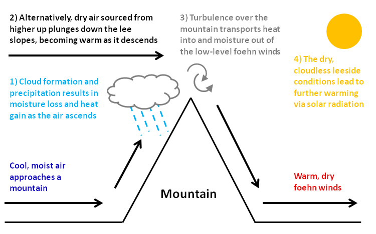
A Foehn or Föhn (, , ), is a type of dry, relatively warm, downslope wind that occurs in the lee (downwind side) of a mountain range. It is a rain shadow wind that results from the subsequent adiabatic warming of air that has dropped most of its moisture on windward slopes (see orographic lift). As a consequence of the different adiabatic lapse rates of moist and dry air, the air on the leeward slopes becomes warmer than equivalent elevations on the windward slopes. Foehn winds can raise temperatures by as much as 14 °C (25 °F) in just a matter of hours. Switzerland, southern Germany and Austria have a warmer climate due to the Foehn, as moist winds off the Mediterranean Sea blow over the Alps. Etymology The name ''Foehn'' (german: Föhn, ) arose in the Alpine region. Originating from Latin ''(ventus) favonius'', a mild west wind of which Favonius was the Roman personification and probably transmitted by rm, favuogn or just ''fuogn'', the term was adopted as g ... [...More Info...] [...Related Items...] OR: [Wikipedia] [Google] [Baidu] |
Zona Sur
Zona Sur (''Southern Zone'') is one of the five natural regions on which CORFO divided continental Chile in 1950. Its northern border is formed by the Bío-Bío River, which separates it from the Central Chile Zone. The Southern Zone borders the Pacific Ocean to the west, and to the east lies the Andean mountains and Argentina. Its southern border is the Chacao Channel, which forms the boundary with the Austral Zone. While the Chiloé Archipelago belongs geographically to the Austral Zone in terms of culture and history, it lies closer to the Southern Zone. Geography Although many lakes can be found in the Andean and coastal regions of central Chile, the south (Sur de Chile) has the country's most lakes. Southern Chile stretches from below the Río Bío-Bío at about 37° south latitude to below Isla de Chiloé at about 43.4° south latitude. In this lake district of Chile, the valley between the Andes and the coastal range is closer to sea level, and the hundreds of river ... [...More Info...] [...Related Items...] OR: [Wikipedia] [Google] [Baidu] |
Central Chile
Central Chile (''Zona central'') is one of the five natural regions into which CORFO divided continental Chile in 1950. It is home to a majority of the Chilean population and includes the three largest metropolitan areas—Santiago, Valparaíso, and Concepción. It extends from 32° south latitude to 37° south latitude. Geography Central Chile is one of the five main geographical zones in which Chile is divided. The Chilean Central Valley lies between the coastal range ("Cordillera de la Costa") and the Andes Mountains. To the north is the semi-desert region known as El Norte Chico, (the "little north"), which lies between 28° and 32° south latitude. To the south lies the cooler and wetter Valdivian temperate rain forests ecoregion, in Los Lagos Region; (the latter includes most of South America's temperate rain forests). The Central valley is a fertile region and the agricultural heartland of Chile. Climate The climate is of the temperate Mediterranean type, with t ... [...More Info...] [...Related Items...] OR: [Wikipedia] [Google] [Baidu] |
Chile
Chile, officially the Republic of Chile, is a country in the western part of South America. It is the southernmost country in the world, and the closest to Antarctica, occupying a long and narrow strip of land between the Andes to the east and the Pacific Ocean to the west. Chile covers an area of , with a population of 17.5 million as of 2017. It shares land borders with Peru to the north, Bolivia to the north-east, Argentina to the east, and the Drake Passage in the far south. Chile also controls the Pacific islands of Juan Fernández, Isla Salas y Gómez, Desventuradas, and Easter Island in Oceania. It also claims about of Antarctica under the Chilean Antarctic Territory. The country's capital and largest city is Santiago, and its national language is Spanish. Spain conquered and colonized the region in the mid-16th century, replacing Inca rule, but failing to conquer the independent Mapuche who inhabited what is now south-central Chile. In 1818, after declaring in ... [...More Info...] [...Related Items...] OR: [Wikipedia] [Google] [Baidu] |
Puelche People
The Gününa küna, or sometimes, Puelche ( Mapudungun: ''pwelche'', "people of the east") are indigenous peoples living east of the Andes Mountains in Chile and Southwest Argentina. They spoke the Puelche language. The name "Puelche" was not native, but was given to them by the Mapuche. They were annihilated by plagues and epidemics in the late 18th century, with survivors merging into other groups such as the Mapuche, Het, and Tehuelche. The Puelche are commemorated in the scientific name of a species of lizard, ''Liolaemus puelche'', which is endemic to Mendoza Province, Argentina.. www.reptile-database.org. Currently, there are efforts of revitalizing the language. Sources *Thomas Falkner Thomas Falkner (6 October 1707 – 30 January 1784) was an English Jesuit missionary, explorer and physician, active in the Patagonia region for nearly forty years. His primary work, ''The Description of Patagonia'', was written towards the idea ..., Description of Patagonia and the a ... [...More Info...] [...Related Items...] OR: [Wikipedia] [Google] [Baidu] |
Andes
The Andes, Andes Mountains or Andean Mountains (; ) are the longest continental mountain range in the world, forming a continuous highland along the western edge of South America. The range is long, wide (widest between 18°S – 20°S latitude), and has an average height of about . The Andes extend from north to south through seven South American countries: Venezuela, Colombia, Ecuador, Peru, Bolivia, Chile, and Argentina. Along their length, the Andes are split into several ranges, separated by intermediate depressions. The Andes are the location of several high plateaus—some of which host major cities such as Quito, Bogotá, Cali, Arequipa, Medellín, Bucaramanga, Sucre, Mérida, El Alto and La Paz. The Altiplano plateau is the world's second-highest after the Tibetan plateau. These ranges are in turn grouped into three major divisions based on climate: the Tropical Andes, the Dry Andes, and the Wet Andes. The Andes Mountains are the highest m ... [...More Info...] [...Related Items...] OR: [Wikipedia] [Google] [Baidu] |
Pacific High
The South Pacific High is a semi-permanent subtropical anticyclone located in the southeast Pacific Ocean. The area of high atmospheric pressure and the presence of the Humboldt Current in the underlying ocean make the west coast of Peru and northern Chile extremely arid. The Sechura and Atacama deserts, as the whole climate of Chile, are heavily influenced by this semi-permanent high-pressure area. This high-pressure system plays a major role in the El Niño–Southern Oscillation (ENSO), and it is also a major source of trade winds across the equatorial Pacific. See also * North Pacific High * El Niño–Southern Oscillation * Trade winds * Humboldt Current The Humboldt Current, also called the Peru Current, is a cold, low- salinity ocean current that flows north along the western coast of South America.Montecino, Vivian, and Carina B. Lange. "The Humboldt Current System: Ecosystem components and pr ... References External links * {{Cyclones Climate of Argentina ... [...More Info...] [...Related Items...] OR: [Wikipedia] [Google] [Baidu] |
South Atlantic
The Atlantic Ocean is the second-largest of the world's five oceans, with an area of about . It covers approximately 20% of Earth's surface and about 29% of its water surface area. It is known to separate the " Old World" of Africa, Europe and Asia from the "New World" of the Americas in the European perception of the World. The Atlantic Ocean occupies an elongated, S-shaped basin extending longitudinally between Europe and Africa to the east, and North and South America to the west. As one component of the interconnected World Ocean, it is connected in the north to the Arctic Ocean, to the Pacific Ocean in the southwest, the Indian Ocean in the southeast, and the Southern Ocean in the south (other definitions describe the Atlantic as extending southward to Antarctica). The Atlantic Ocean is divided in two parts, by the Equatorial Counter Current, with the North(ern) Atlantic Ocean and the South(ern) Atlantic Ocean split at about 8°N. Scientific explorations of the Atlanti ... [...More Info...] [...Related Items...] OR: [Wikipedia] [Google] [Baidu] |
Spring (season)
Spring, also known as springtime, is one of the four temperate seasons, succeeding winter and preceding summer. There are various technical definitions of spring, but local usage of the term varies according to local climate, cultures and customs. When it is spring in the Northern Hemisphere, it is autumn in the Southern Hemisphere and vice versa. At the spring (or vernal) equinox, days and nights are approximately twelve hours long, with daytime length increasing and nighttime length decreasing as the season progresses until the Summer Solstice in June (Northern Hemisphere) and December (Southern Hemisphere). Spring and "springtime" refer to the season, and also to ideas of rebirth, rejuvenation, renewal, resurrection and regrowth. Subtropical and tropical areas have climates better described in terms of other seasons, e.g. dry or wet, monsoonal or cyclonic. Cultures may have local names for seasons which have little equivalence to the terms originating in Europe. Meteoro ... [...More Info...] [...Related Items...] OR: [Wikipedia] [Google] [Baidu] |
Snow Melt
In hydrology, snowmelt is surface runoff produced from melting snow. It can also be used to describe the period or season during which such runoff is produced. Water produced by snowmelt is an important part of the annual water cycle in many parts of the world, in some cases contributing high fractions of the annual runoff in a watershed. Predicting snowmelt runoff from a drainage basin may be a part of designing water control projects. Rapid snowmelt can cause flooding. If the snowmelt is then frozen, very dangerous conditions and accidents can occur, introducing the need for salt to melt the ice. Energy fluxes related to snowmelt There are several energy fluxes involved in the melting of snow. These fluxes can act in opposing directions, that is either delivering heat to or removing heat from the snowpack. Ground heat flux is the energy delivered to the snowpack from the soil below by conduction. Radiation inputs to the snowpack include net shortwave (solar radiation including ... [...More Info...] [...Related Items...] OR: [Wikipedia] [Google] [Baidu] |
Albedo
Albedo (; ) is the measure of the diffuse reflection of sunlight, solar radiation out of the total solar radiation and measured on a scale from 0, corresponding to a black body that absorbs all incident radiation, to 1, corresponding to a body that reflects all incident radiation. Surface albedo is defined as the ratio of Radiosity (radiometry), radiosity ''J''e to the irradiance ''E''e (flux per unit area) received by a surface. The proportion reflected is not only determined by properties of the surface itself, but also by the spectral and angular distribution of solar radiation reaching the Earth's surface. These factors vary with atmospheric composition, geographic location, and time (see position of the Sun). While bi-hemispherical reflectance is calculated for a single angle of incidence (i.e., for a given position of the Sun), albedo is the directional integration of reflectance over all solar angles in a given period. The temporal resolution may range from seconds (as ob ... [...More Info...] [...Related Items...] OR: [Wikipedia] [Google] [Baidu] |


.jpg)


