|
Panangad, Kochi
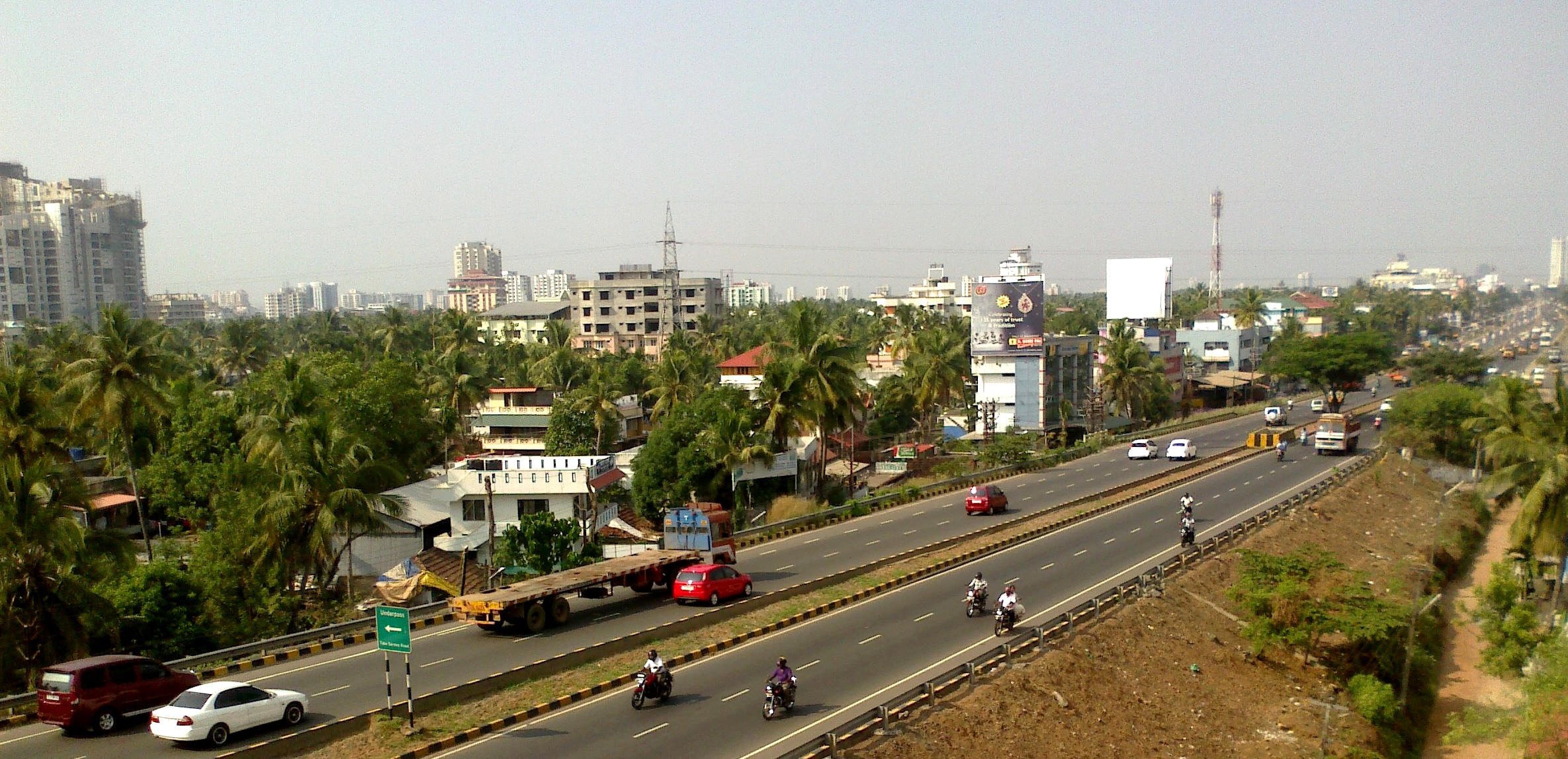
Panangad is a suburban village in Kochi, Kerala state in India. It lies in the skirts of Kochi Bypass. Located only 7.5 km from Vytilla junction and accessible through the national highway 66(N.H.66) by taking a left from Madavana junction while travelling south along the Kochi Bypass. Panangad is one of the suburban villages that make up the urban agglomeration of Kochi. Only 7.5 Km from Vytilla Jn. It was merged into the city during the expansion of Kochi city limits which ends at Kumbalam. The area after the Kumbalam bridge from Aroor belongs to Alappuzha district. Office Villages of Panangad, Kumbalam are all under Kumbalam Panchayath, and the panchayath office is located at Panangad. Also veterinary clinic and some other small offices work at the same plaza. Post office Panangad post office is an all women office located somewhere at middle of village in a place called Mundempalli. Hospital Also primary government health clinic is located nearby post office about 30 ... [...More Info...] [...Related Items...] OR: [Wikipedia] [Google] [Baidu] |
Kochi
Kochi (), also known as Cochin ( ) ( the official name until 1996) is a major port city on the Malabar Coast of India bordering the Laccadive Sea, which is a part of the Arabian Sea. It is part of the district of Ernakulam in the state of Kerala and is commonly referred to as Ernakulam. Kochi is the most densely populated city in Kerala. As of 2011, it has a corporation limit population of 677,381 within an area of 94.88 km2 and a total urban population of more than of 2.1 million within an area of 440 km2, making it the largest and the most populous metropolitan area in Kerala. Kochi city is also part of the Greater Cochin region and is classified as a Tier-II city by the Government of India. The civic body that governs the city is the Kochi Municipal Corporation, which was constituted in the year 1967, and the statutory bodies that oversee its development are the Greater Cochin Development Authority (GCDA) and the Goshree Islands Development Authority (GIDA). ... [...More Info...] [...Related Items...] OR: [Wikipedia] [Google] [Baidu] |
Kerala
Kerala ( ; ) is a state on the Malabar Coast of India. It was formed on 1 November 1956, following the passage of the States Reorganisation Act, by combining Malayalam-speaking regions of the erstwhile regions of Cochin, Malabar, South Canara, and Thiruvithamkoor. Spread over , Kerala is the 21st largest Indian state by area. It is bordered by Karnataka to the north and northeast, Tamil Nadu to the east and south, and the Lakshadweep Sea to the west. With 33 million inhabitants as per the 2011 census, Kerala is the 13th-largest Indian state by population. It is divided into 14 districts with the capital being Thiruvananthapuram. Malayalam is the most widely spoken language and is also the official language of the state. The Chera dynasty was the first prominent kingdom based in Kerala. The Ay kingdom in the deep south and the Ezhimala kingdom in the north formed the other kingdoms in the early years of the Common Era (CE). The region had been a prominent spic ... [...More Info...] [...Related Items...] OR: [Wikipedia] [Google] [Baidu] |
Kochi Bypass
The Kochi Bypass is a segment of NH66(National Highway 66) that bypasses the CBD of the city of Kochi in Kerala, India. The highway stretches 17 km from Edapally in the Ernakulam district to Aroor in Alappuzha district , via. Palarivattom, Vyttila, Kundannoor, Madavana, Kumbalam. The Government of Kerala began the preliminary works in 1973. After a slow progress, it was partially opened for traffic in the beginning years of the 1980s. The section between Edapally and Vyttila had four lanes from the beginning. The rest of the carriageway was also upgraded to different sections of 4 lane, 5lane and 6 lanes by 2010 The idea was to bypass the truck traffic out of the city proper. However now the city has outgrown the bypass leading to a heavy suburban traffic. Today, this road has turned out to be the most important arterial road in Kochi. The spacious road is going to replace the MG Road as the state's major commercial avenue in a few years time. Space crunch has really ... [...More Info...] [...Related Items...] OR: [Wikipedia] [Google] [Baidu] |
Vytilla
Vyttila, , is an intersection as well as the name of a region in the city of Kochi, in the state of Kerala, India. It is the busiest as well as one of the largest intersections in Kerala. This node intersects the main north–south artery of the state of ''Kerala'', namely, the Kochi Bypass, with three city roads of ''Kochi'' viz, the S. A. Road (One of the city's most prominent arterial road in the east–west direction), the ''Vyttila-Petta Road'', and the ''Thammanam Road''. The name ''Vyttila'' is said to be evolved from the word "Vayal Thala" meaning the main part of the paddy field. Once the area including Elamkulam, were paddy fields and paddy cultivation were the main sources of income. The paddy field existed from Ernakulam, Girinagar, Panampilly Nagar, Gandhi Nagar, Jawahar Nagar, Kumarananshan Nagar and extended to Kaniyampuzha and Panamkutyy bridge. Some also say that because there existed a bunch of dacoits, who murdered and looted the travelers the name evolve ... [...More Info...] [...Related Items...] OR: [Wikipedia] [Google] [Baidu] |
Kumbalam, Ernakulam
Kumbalam is a picturesque region in Kochi, in the state of Kerala, India. A water-bound countryside, bound by the Vembanad Lake, as well as the fast-encroaching city of Kochi, it is situated around 9 km from Vytilla Vyttila, , is an intersection as well as the name of a region in the city of Kochi, in the state of Kerala, India. It is the busiest as well as one of the largest intersections in Kerala. This node intersects the main north–south artery of ... Junction. Location Neighbourhoods in Kochi {{Ernakulam-geo-stub Kumbalam is surrounded by Thevara in North, Wellington Island in North West, Edakochi in West, Kumbalangi in South West, Aroor in South, Panangad in Eastern side, Nettoor in North Eastern side. ... [...More Info...] [...Related Items...] OR: [Wikipedia] [Google] [Baidu] |
Aroor
Aroor is a census town at the northern end of Alappuzha district and the southern suburb of the city of Kochi in the state of Kerala, India. It is a seafood related industrial area of Alleppey district, and acts as the Southern entry point into Kochi city. Aroor is at present a municipality located just south of Kochi Urban Agglomeration. It is expected to be a part of Kochi UA in the upcoming census, since its urban growth is now continuous with Kochi city. Location Aroor is the northernmost tip of Alappuzha district and lies on the National Highway 66 at the south end of Kochi Bypass. It is around 14km south of Ernakulam, the city centre of Kochi, which is the largest city in Kerala widely known as its commercial hub. Aroor is linked to the nearby land Kumbalam island in Kochi, through a bridge. The Aroor-Kumbalam Bridge is the second-longest bridge (now the bridge is doubled with four-lane traffic) in Kerala, spanning about 993 m. It links Aroor with Kochi city at Kum ... [...More Info...] [...Related Items...] OR: [Wikipedia] [Google] [Baidu] |
Lakeshore Hospital
VPS Lakeshore, also known as Lakeshore Hospital is a multi super-speciality Hospital in Kochi, Kerala, India. It is located along National Highway 66 in Nettoor, and is a 650-bedded facility with over 30 clinical departments. The hospital is headed by Shamsheer Vayalil, the founder and managing director of VPS Healthcare. Profile VPS Lakeshore Hospital and Research Centre Ltd was found by Dr.Philip Augustine registered as a public limited company in 1996 and started functioning as a multi-specialty hospital in January 2003. The hospital is accredited by the National Accreditation Board for Hospitals & Healthcare Providers (NABH) and has 43 intensive care units and 10 operation theatres. It is one of the largest tertiary care hospital in the state and is managed by VPS Healthcare, which took over the management from Philip Augustine in April 2016. It has air, water and surface ambulance services which was listed by the Limca Book of Records in 2004. Besides medical care, it also co ... [...More Info...] [...Related Items...] OR: [Wikipedia] [Google] [Baidu] |
Islands Of Kerala
An island (or isle) is an isolated piece of habitat that is surrounded by a dramatically different habitat, such as water. Very small islands such as emergent land features on atolls can be called islets, skerries, cays or keys. An island in a river or a lake island may be called an eyot or ait, and a small island off the coast may be called a holm. Sedimentary islands in the Ganges delta are called chars. A grouping of geographically or geologically related islands, such as the Philippines, is referred to as an archipelago. There are two main types of islands in the sea: continental and oceanic. There are also artificial islands, which are man-made. Etymology The word ''island'' derives from Middle English ''iland'', from Old English ''igland'' (from ''ig'' or ''ieg'', similarly meaning 'island' when used independently, and -land carrying its contemporary meaning; cf. Dutch ''eiland'' ("island"), German ''Eiland'' ("small island")). However, the spelling of the word w ... [...More Info...] [...Related Items...] OR: [Wikipedia] [Google] [Baidu] |
.jpg)


