|
Mowry Shale
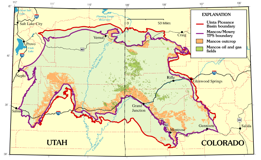
The Mowry Shale is an Early Cretaceous geologic formation. The formation was named for Mowrie Creek, northwest of Buffalo in Johnson County, Wyoming. Description The Mowry Shale or Fish-scale Beds because of the abundance of fish scales, is a dark-gray, siliceous shale that weathers silver gray; it is 10-70 m thick. 40Ar/39Ar of sanidine from a bentonite yielded an age of 97.17 +/-0.69 Ma, thus is Cenomanian in age. Fossils indicate the Mowry was deposited during the early stages of the Western Interior Seaway. Age In so much as the Mowry was observed to lie above formations that were originally thought to be associated with the difficult to date upper Dakota units, especially Newcastle Sandstone, the Mowry was previously thought to be of Cenomanian age. However, recent studies, particularly of fossil pollens and spores, have dated the Mowry to the late-Albian. In many locations, the Mowry is bounded above by the Clay Spur bentonite, which is assigned the radiometric dat ... [...More Info...] [...Related Items...] OR: [Wikipedia] [Google] [Baidu] |
Geological Formation
A geological formation, or simply formation, is a body of rock having a consistent set of physical characteristics ( lithology) that distinguishes it from adjacent bodies of rock, and which occupies a particular position in the layers of rock exposed in a geographical region (the stratigraphic column). It is the fundamental unit of lithostratigraphy, the study of strata or rock layers. A formation must be large enough that it can be mapped at the surface or traced in the subsurface. Formations are otherwise not defined by the thickness of their rock strata, which can vary widely. They are usually, but not universally, tabular in form. They may consist of a single lithology (rock type), or of alternating beds of two or more lithologies, or even a heterogeneous mixture of lithologies, so long as this distinguishes them from adjacent bodies of rock. The concept of a geologic formation goes back to the beginnings of modern scientific geology. The term was used by Abraham Gottlob Wer ... [...More Info...] [...Related Items...] OR: [Wikipedia] [Google] [Baidu] |
Colorado
Colorado (, other variants) is a state in the Mountain West subregion of the Western United States. It encompasses most of the Southern Rocky Mountains, as well as the northeastern portion of the Colorado Plateau and the western edge of the Great Plains. Colorado is the eighth most extensive and 21st most populous U.S. state. The 2020 United States census enumerated the population of Colorado at 5,773,714, an increase of 14.80% since the 2010 United States census. The region has been inhabited by Native Americans and their ancestors for at least 13,500 years and possibly much longer. The eastern edge of the Rocky Mountains was a major migration route for early peoples who spread throughout the Americas. "''Colorado''" is the Spanish adjective meaning "ruddy", the color of the Fountain Formation outcroppings found up and down the Front Range of the Rocky Mountains. The Territory of Colorado was organized on February 28, 1861, and on August 1, 1876, U.S. President Ulyss ... [...More Info...] [...Related Items...] OR: [Wikipedia] [Google] [Baidu] |
Powder River Basin
The Powder River Basin is a geologic structural basin in southeast Montana and northeast Wyoming, about east to west and north to south, known for its extensive coal reserves. The former hunting grounds of the Oglala Lakota, the area is very sparsely populated and is known for its rolling grasslands and semiarid climate. The basin is both a topographic drainage and geologic structural basin, drained by the Powder River, Cheyenne River, Tongue River, Bighorn River, Little Missouri River, Platte River, and their tributaries. The major cities in the area include Gillette and Sheridan, Wyoming and Miles City, Montana. In 2007, the region produced 436 million short tons (396 million tonnes) of coal, more than twice the production of second-place West Virginia, and more than the entire Appalachian region. The Powder River Basin is the largest coal-producing region in the United States. The region includes the Black Thunder Coal Mine, the most productive in the United States, ... [...More Info...] [...Related Items...] OR: [Wikipedia] [Google] [Baidu] |
North Park (Colorado Basin)
North Park is a high, sparsely populated basin (approximately in elevation) in the Rocky Mountains in north central Colorado in the United States. It encompasses a wide valley in Jackson County rimmed by mountain ranges at the headwaters of the North Platte River and several smaller tributaries, including the Michigan River, Illinois River, and Canadian River. The valley receives its name from being the northernmost of the three large mountain valleys (or parks) in Colorado on the western side of the Front Range. The others are Middle Park and South Park respectively. The basin opens out northward into Wyoming, in the direction of flow of the North Platte. On the east side, it is rimmed by the Medicine Bow Mountains, the Never Summer Mountains and Rabbit Ears Range to the south, and the Park Range to the west. The continental divide rims the Park along the south and west. The valley along the Illinois River is the location of the Arapaho National Wildlife Refuge. The larges ... [...More Info...] [...Related Items...] OR: [Wikipedia] [Google] [Baidu] |
Montana Fold Belt
Montana () is a state in the Mountain West division of the Western United States. It is bordered by Idaho to the west, North Dakota and South Dakota to the east, Wyoming to the south, and the Canadian provinces of Alberta, British Columbia, and Saskatchewan to the north. It is the fourth-largest state by area, the eighth-least populous state, and the third-least densely populated state. Its state capital is Helena. The western half of Montana contains numerous mountain ranges, while the eastern half is characterized by western prairie terrain and badlands, with smaller mountain ranges found throughout the state. Montana has no official nickname but several unofficial ones, most notably "Big Sky Country", "The Treasure State", "Land of the Shining Mountains", and " The Last Best Place". The economy is primarily based on agriculture, including ranching and cereal grain farming. Other significant economic resources include oil, gas, coal, mining, and lumber. The health ca ... [...More Info...] [...Related Items...] OR: [Wikipedia] [Google] [Baidu] |
Green River Basin
Green is the color between cyan and yellow on the visible spectrum. It is evoked by light which has a dominant wavelength of roughly 495570 nm. In subtractive color systems, used in painting and color printing, it is created by a combination of yellow and cyan; in the RGB color model, used on television and computer screens, it is one of the additive primary colors, along with red and blue, which are mixed in different combinations to create all other colors. By far the largest contributor to green in nature is chlorophyll, the chemical by which plants photosynthesize and convert sunlight into chemical energy. Many creatures have adapted to their green environments by taking on a green hue themselves as camouflage. Several minerals have a green color, including the emerald, which is colored green by its chromium content. During post-classical and early modern Europe, green was the color commonly associated with wealth, merchants, bankers, and the gentry, while red was r ... [...More Info...] [...Related Items...] OR: [Wikipedia] [Google] [Baidu] |
Denver Basin
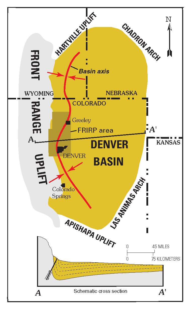
The Denver Basin, variously referred to as the Julesburg Basin, Denver-Julesburg Basin (after Julesburg, Colorado), or the D-J Basin, is a geologic structural basin centered in eastern Colorado in the United States, but extending into southeast Wyoming, western Nebraska, and western Kansas. It underlies the Denver-Aurora Metropolitan Area on the eastern side of the Rocky Mountains. Geology The basin consists of a large asymmetric syncline of Paleozoic, Mesozoic, and Cenozoic sedimentary rock layers, trending north to south along the east side of the Front Range from the vicinity of Pueblo northward into Wyoming. The basin is deepest near Denver, where it reaches a depth of approximately 13,000 ft (3900 m) below the surface. The basin is strongly asymmetric: the Dakota Sandstone outcrops in a "hog-back" ridge near Morrison a few miles west of Denver, reaches its maximum depth beneath Denver, then ascends very gradually to its eastern outcrop in central Kansas. The Dakota ho ... [...More Info...] [...Related Items...] OR: [Wikipedia] [Google] [Baidu] |
Chadron Arch
Chadron may refer to: * Chadron, Nebraska, United States * Chadron, Haute-Loire, France * Chadron State College Chadron State College is a public college in Chadron, Nebraska, US. It is one of three public colleges in the Nebraska State College System. It has open admission and an acceptance rate of 100%. According to College Factual, it has a six-year g ..., a college in Chadron, Nebraska * Hotel Chadron, a hotel in Chadron, Nebraska * Chadron Moore, also known by his stage name Nitti Beatz, American record producer {{place name disambiguation ... [...More Info...] [...Related Items...] OR: [Wikipedia] [Google] [Baidu] |
Central Montana Uplift
Central is an adjective usually referring to being in the center of some place or (mathematical) object. Central may also refer to: Directions and generalised locations * Central Africa, a region in the centre of Africa continent, also known as Middle Africa * Central America, a region in the centre of America continent * Central Asia, a region in the centre of Eurasian continent * Central Australia, a region of the Australian continent * Central Belt, an area in the centre of Scotland * Central Europe, a region of the European continent * Central London, the centre of London * Central Region (other) * Central United States, a region of the United States of America Specific locations Countries * Central African Republic, a country in Africa States and provinces * Blue Nile (state) or Central, a state in Sudan * Central Department, Paraguay * Central Province (Kenya) * Central Province (Papua New Guinea) * Central Province (Solomon Islands) * Central Province, Sri Lank ... [...More Info...] [...Related Items...] OR: [Wikipedia] [Google] [Baidu] |
Big Horn Basin
The Bighorn Basin is a plateau region and intermontane basin, approximately 100 miles (160 km) wide, in north-central Wyoming in the United States. It is bounded by the Absaroka Range on the west, the Pryor Mountains on the north, the Bighorn Mountains on the east, and the Owl Creek Mountains and Bridger Mountains on the south. It is drained to the north by tributaries of the Bighorn River, which enters the basin from the south, through a gap between the Owl Creek and Bridger Mountains, as the Wind River, and becomes the Bighorn as it enters the basin. The region is semi-arid, receiving only 6–10 in (15–25 cm) of rain annually. The largest cities in the basin include the Wyoming towns of Cody, Thermopolis, Worland, and Powell. Sugar beets, pinto beans, sunflowers, barley, oats, corn and alfalfa hay are grown on irrigated farms in the region. History The basin was explored by John Colter in 1807. Just west of Cody, he discovered geothermal features that were la ... [...More Info...] [...Related Items...] OR: [Wikipedia] [Google] [Baidu] |
Wyoming
Wyoming () is a U.S. state, state in the Mountain states, Mountain West subregion of the Western United States. It is bordered by Montana to the north and northwest, South Dakota and Nebraska to the east, Idaho to the west, Utah to the southwest, and Colorado to the south. With a population of 576,851 in the 2020 United States census, Wyoming is the List of U.S. states and territories by population, least populous state despite being the List of U.S. states and territories by area, 10th largest by area, with the List of U.S. states by population density, second-lowest population density after Alaska. The state capital and List of municipalities in Wyoming, most populous city is Cheyenne, Wyoming, Cheyenne, which had an estimated population of 63,957 in 2018. Wyoming's western half is covered mostly by the ranges and rangelands of the Rocky Mountains, while the eastern half of the state is high-elevation prairie called the High Plains (United States), High Plains. It is drier ... [...More Info...] [...Related Items...] OR: [Wikipedia] [Google] [Baidu] |
Utah
Utah ( , ) is a state in the Mountain West subregion of the Western United States. Utah is a landlocked U.S. state bordered to its east by Colorado, to its northeast by Wyoming, to its north by Idaho, to its south by Arizona, and to its west by Nevada. Utah also touches a corner of New Mexico in the southeast. Of the fifty U.S. states, Utah is the 13th-largest by area; with a population over three million, it is the 30th-most-populous and 11th-least-densely populated. Urban development is mostly concentrated in two areas: the Wasatch Front in the north-central part of the state, which is home to roughly two-thirds of the population and includes the capital city, Salt Lake City; and Washington County in the southwest, with more than 180,000 residents. Most of the western half of Utah lies in the Great Basin. Utah has been inhabited for thousands of years by various indigenous groups such as the ancient Puebloans, Navajo and Ute. The Spanish were the first Europe ... [...More Info...] [...Related Items...] OR: [Wikipedia] [Google] [Baidu] |


