|
Marmolejo
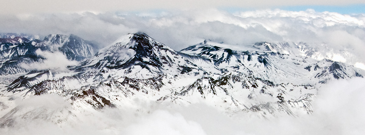
Volcán Marmolejo is a high Pleistocene stratovolcano in the Andes on the border between Argentina and Chile. It is located NNE of the active San José volcano, and is the southernmost -plus peak in the world. The Argentine portion is within the Argentinean protection area of Provincial Reserve for Multiple Use and Natural Recreation Manzano / Portillo de Piuquenes. It is on the border of two provinces: Argentinean province of Mendoza and Chilean province of Cordillera. Its slopes are within the administrative boundaries of the two cities: Argentinean city of Tunuyán and the Chilean commune of San José de Maipo. First ascent Marmolejo was first climbed by Hermann Sattler, Sebastian Krückel and Albrecht Maass (Germany) October 1, 1928. Elevation It has an official height of 6108 meters. Other data from available digital elevation models: SRTM yields 6097 metres, ASTER 6103 metres, ALOS 6085 metres and TanDEM-X 6129 metres. The height of the nearest key col is 4005 ... [...More Info...] [...Related Items...] OR: [Wikipedia] [Google] [Baidu] |
Marmolejo Volcano, Central Chile
Volcán Marmolejo is a high Pleistocene stratovolcano in the Andes on the border between Argentina and Chile. It is located NNE of the active San José volcano, and is the southernmost -plus peak in the world. The Argentine portion is within the Argentinean protection area of Provincial Reserve for Multiple Use and Natural Recreation Manzano / Portillo de Piuquenes. It is on the border of two provinces: Argentinean province of Mendoza and Chilean province of Cordillera. Its slopes are within the administrative boundaries of the two cities: Argentinean city of Tunuyán and the Chilean commune of San José de Maipo. First ascent Marmolejo was first climbed by Hermann Sattler, Sebastian Krückel and Albrecht Maass (Germany) October 1, 1928. Elevation It has an official height of 6108 meters. Other data from available digital elevation models: SRTM yields 6097 metres, ASTER 6103 metres, ALOS 6085 metres and TanDEM-X 6129 metres. The height of the nearest key col is 4005 me ... [...More Info...] [...Related Items...] OR: [Wikipedia] [Google] [Baidu] |
Andes
The Andes, Andes Mountains or Andean Mountains (; ) are the longest continental mountain range in the world, forming a continuous highland along the western edge of South America. The range is long, wide (widest between 18°S – 20°S latitude), and has an average height of about . The Andes extend from north to south through seven South American countries: Venezuela, Colombia, Ecuador, Peru, Bolivia, Chile, and Argentina. Along their length, the Andes are split into several ranges, separated by intermediate depressions. The Andes are the location of several high plateaus—some of which host major cities such as Quito, Bogotá, Cali, Arequipa, Medellín, Bucaramanga, Sucre, Mérida, El Alto and La Paz. The Altiplano plateau is the world's second-highest after the Tibetan plateau. These ranges are in turn grouped into three major divisions based on climate: the Tropical Andes, the Dry Andes, and the Wet Andes. The Andes Mountains are the highest m ... [...More Info...] [...Related Items...] OR: [Wikipedia] [Google] [Baidu] |
San José (volcano)
San José Volcano is the stratovolcano that gives its name to a massive volcanic group, at about from Santiago de Chile at the end of the Cajón del Maipo on the Chile-Argentina border. It lies on the south end of an approximately x complex that includes the La Engorda, Espiritu Santo, Plantat and Marmolejo volcanoes, the latter of which is located on the Northern end of the group. See also * List of volcanoes in Argentina * List of volcanoes in Chile The Smithsonian Institution's Global Volcanism Program lists 105 volcanoes in Chile that have been active during the Holocene. [...More Info...] [...Related Items...] OR: [Wikipedia] [Google] [Baidu] |
Tupungato
Tupungato, one of the highest mountains in the Americas, is a massive Andean lava dome dating to Pleistocene times. It lies on the border between the Chilean Metropolitan Region (near a major international highway about east of Santiago) and the Argentine province of Mendoza, about south of Aconcagua, the highest peak of both the Southern and Western hemispheres. Immediately to its southwest is the active Tupungatito volcano (literally, ''little Tupungato''), which last erupted in 1987. Tupungato Department, an important Argentine wine-producing region in Mendoza province, is named for the volcano. Recent Chilean mapping indicates it has a height of 6635m. 1947 plane crash On 2 August 1947, the airliner '' Star Dust'', an Avro Lancastrian carrying six passengers and five crew over the Andes range, crashed into a steep glacier high on the Argentine side of Tupungato. The plane was quickly buried in the resulting avalanche and heavy snowfall that was taking place at the time. ... [...More Info...] [...Related Items...] OR: [Wikipedia] [Google] [Baidu] |
Topographic Prominence
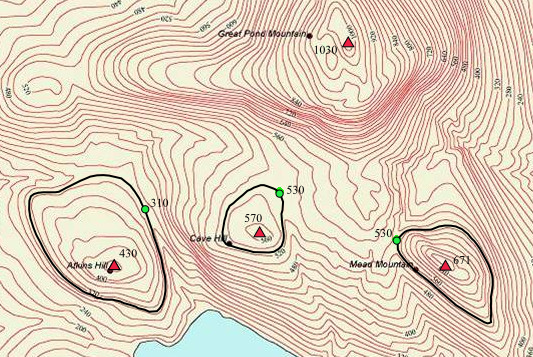
In topography, prominence (also referred to as autonomous height, relative height, and shoulder drop in US English, and drop or relative height in British English) measures the height of a mountain or hill's summit relative to the lowest contour line encircling it but containing no higher summit within it. It is a measure of the independence of a summit. A peak's ''key col'' (the highest col surrounding the peak) is a unique point on this contour line and the ''parent peak'' is some higher mountain, selected according to various criteria. Definitions The prominence of a peak may be defined as the least drop in height necessary in order to get from the summit to any higher terrain. This can be calculated for a given peak in the following way: for every path connecting the peak to higher terrain, find the lowest point on the path; the ''key col'' (or ''key Saddle point, saddle'', or ''linking col'', or ''link'') is defined as the highest of these points, along all connecting pat ... [...More Info...] [...Related Items...] OR: [Wikipedia] [Google] [Baidu] |
Parent Peak
In topography, prominence (also referred to as autonomous height, relative height, and shoulder drop in US English, and drop or relative height in British English) measures the height of a mountain or hill's summit relative to the lowest contour line encircling it but containing no higher summit within it. It is a measure of the independence of a summit. A peak's ''key col'' (the highest col surrounding the peak) is a unique point on this contour line and the ''parent peak'' is some higher mountain, selected according to various criteria. Definitions The prominence of a peak may be defined as the least drop in height necessary in order to get from the summit to any higher terrain. This can be calculated for a given peak in the following way: for every path connecting the peak to higher terrain, find the lowest point on the path; the ''key col'' (or ''key saddle'', or ''linking col'', or ''link'') is defined as the highest of these points, along all connecting paths; the prom ... [...More Info...] [...Related Items...] OR: [Wikipedia] [Google] [Baidu] |
Topographic Isolation
The topographic isolation of a summit is the minimum distance to a point of equal elevation, representing a radius of dominance in which the peak is the highest point. It can be calculated for small hills and islands as well as for major mountain peaks and can even be calculated for submarine summits. Isolation table The following sortable table lists Earth's 40 most topographically isolated summits. Examples *The nearest peak to Germany's highest mountain, the 2,962-metre-high Zugspitze, that has a 2962-metre-contour is the Zwölferkogel (2,988 m) in Austria's Stubai Alps. The distance between the Zugspitze and this contour is 25.8 km; the Zugspitze is thus the highest peak for a radius of 25.8 km around. Its isolation is thus 25.8 km. *Because there are no higher mountains than Mount Everest, it has no definitive isolation. Many sources list its isolation as the circumference of the earth over the poles or – questionably, because there is no agreed def ... [...More Info...] [...Related Items...] OR: [Wikipedia] [Google] [Baidu] |
Kilometers
The kilometre ( SI symbol: km; or ), spelt kilometer in American English, is a unit of length in the International System of Units (SI), equal to one thousand metres (kilo- being the SI prefix for ). It is now the measurement unit used for expressing distances between geographical places on land in most of the world; notable exceptions are the United States and the United Kingdom where the statute mile is the unit used. The abbreviations k or K (pronounced ) are commonly used to represent kilometre, but are not recommended by the BIPM. A slang term for the kilometre in the US, UK, and Canadian militaries is ''klick''. Pronunciation There are two common pronunciations for the word. # # The first pronunciation follows a pattern in English whereby metric units are pronounced with the stress on the first syllable (as in kilogram, kilojoule and kilohertz) and the pronunciation of the actual base unit does not change irrespective of the prefix (as in centimetre, millimetre, n ... [...More Info...] [...Related Items...] OR: [Wikipedia] [Google] [Baidu] |
List Of Volcanoes In Chile
The Smithsonian Institution's Global Volcanism Program lists 105 volcanoes in Chile that have been active during the Holocene. using Chile, Chile-Peru, Chile-Bolivia and Chile-Argentina options, retrieved on 10 November 2013 The country's lists 90 active volcanoes. The volcanoes of the originate from the of the [...More Info...] [...Related Items...] OR: [Wikipedia] [Google] [Baidu] |
List Of Volcanoes In Argentina
This is a list of active and extinct volcanoes in Argentina. Volcanoes {, class="wikitable sortable" style="text-align:right;" , - style="text-align:center;" ! rowspan="2" , Name ! rowspan="2" , Type ! colspan="2" , Elevation ! Location ! rowspan="2" , Last eruption , - style="text-align:center;" ! meters ! feet ! Coordinates , - , align="left" , Agua Poca , , Cinder Cone , , 657 , , 2,156 , , , , 600,000 years ago , - , align="left" , Aguas Calientes , , Caldera , , 4,473 , , 14,675 , , , , 200,000 years ago , - , align="left" , Aguiliri , , Lava Dome Complex , , , , , , , , 12.7 mya , - , align="left" , Antilla , , Complex volcano , , , , , , , , 4.67 mya , - , align="left" , Antofagasta de la Sierra , , Volcanic field , , 4,000 , , 13,123 , , , , Unknown , - , align="left" , Antofalla , , Stratovolcano , , 6,440 , , 20,013 , , , , Unknown , - , align="left" , Aracar , , Stratovolcano , , 6,082 , , 19,954 , , , , 19 ... [...More Info...] [...Related Items...] OR: [Wikipedia] [Google] [Baidu] |
Key Col
In topography, prominence (also referred to as autonomous height, relative height, and shoulder drop in US English, and drop or relative height in British English) measures the height of a mountain or hill's summit relative to the lowest contour line encircling it but containing no higher summit within it. It is a measure of the independence of a summit. A peak's ''key col'' (the highest col surrounding the peak) is a unique point on this contour line and the ''parent peak'' is some higher mountain, selected according to various criteria. Definitions The prominence of a peak may be defined as the least drop in height necessary in order to get from the summit to any higher terrain. This can be calculated for a given peak in the following way: for every path connecting the peak to higher terrain, find the lowest point on the path; the ''key col'' (or ''key saddle'', or ''linking col'', or ''link'') is defined as the highest of these points, along all connecting paths; the prom ... [...More Info...] [...Related Items...] OR: [Wikipedia] [Google] [Baidu] |

.jpg)

