|
Tupungato
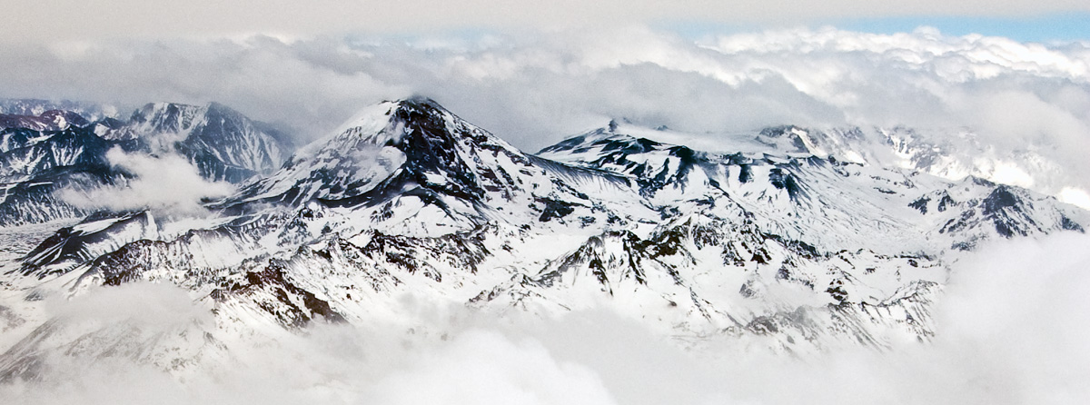
Tupungato, one of the highest mountains in the Americas, is a massive Andean lava dome dating to Pleistocene times. It lies on the border between the Chilean Metropolitan Region (near a major international highway about east of Santiago) and the Argentine province of Mendoza, about south of Aconcagua, the highest peak of both the Southern and Western hemispheres. Immediately to its southwest is the active Tupungatito volcano (literally, ''little Tupungato''), which last erupted in 1987. Tupungato Department, an important Argentine wine-producing region in Mendoza province, is named for the volcano. Recent Chilean mapping indicates it has a height of 6635m. 1947 plane crash On 2 August 1947, the airliner ''Star Dust'', an Avro Lancastrian carrying six passengers and five crew over the Andes range, crashed into a steep glacier high on the Argentine side of Tupungato. The plane was quickly buried in the resulting avalanche and heavy snowfall that was taking place at the ti ... [...More Info...] [...Related Items...] OR: [Wikipedia] [Google] [Baidu] |
Tupungatito
Volcán Tupungatito is the northernmost historically active stratovolcano of the southern Andes. Part of the Chilean Andes' volcanic segment, it is the northernmost member of the Southern Volcanic Zone (SVZ), which is one of several distinct volcanic belts in the Andes. Over 70 Pleistocene or Holocene age volcanoes make up this volcanic belt, which on average has one eruption per year. Tupungatito lies in proximity to the border between Argentina and Chile, 50 miles east of the Chilean capital Santiago. It is a group of volcanic craters and a pyroclastic cone associated with a wide caldera, and lies just southwest of the Tupungato volcano. The caldera is filled with ice, and glaciers on the volcano are important sources of water for the Rio Maipo river and Santiago. Volcanism is caused by the subduction of the Nazca Plate underneath the South America Plate. Tupungatito formed less than 100,000 years ago and has had a number of historical eruptions, the latest in 1987, which w ... [...More Info...] [...Related Items...] OR: [Wikipedia] [Google] [Baidu] |
Star Dust (aircraft)
On 2 August 1947, ''Star Dust'', a British South American Airways (BSAA) Avro Lancastrian airliner on a flight from Buenos Aires, Argentina, to Santiago, Chile, crashed into Mount Tupungato in the Argentine Andes. An extensive search operation failed to locate the wreckage, despite covering the area of the crash site. The fate of the aircraft and its occupants remained unknown for over fifty years, giving rise to various conspiracy theories about its disappearance. In the late 1990s, pieces of wreckage from the missing aircraft began to emerge from the glacial ice. It is now believed that the crew became confused as to their exact location while flying at high altitudes through the (then poorly understood) jet stream. Mistakenly believing they had already cleared the mountain tops, they started their descent when they were in fact still behind cloud-covered peaks. ''Star Dust'' crashed into Mount Tupungato, killing all aboard and burying itself in snow and ice. The la ... [...More Info...] [...Related Items...] OR: [Wikipedia] [Google] [Baidu] |
Tupungato Department
Tupungato is a department located in the province of Mendoza, Argentina. The cabecera (departmental capital), Tupungato, is located approximately south of Mendoza city, in the Valle de Uco. Its name comes from the Tupungato volcano (at 6,570 metres, one of Argentina's highest peaks). The volcano's name is said to mean "star viewpoint" in the Huarpe language. The department is approximately 1,200 metres above mean sea level, and comprises 2.485 km² (1.6% of the provincial total). According to the , the total population of the department was 28,539 with a density of 11.48 inhabitants per km². The region is mainly dependent on agricultural production, with vineyards being its most important produce, representing 30% of the planted lands. Other regional products are fruit (mainly peach) and garlic. The wine industry, however, is particularly relevant due to the constant investments and intensive labour occupation. Recent developments in the Argentine economy have further ... [...More Info...] [...Related Items...] OR: [Wikipedia] [Google] [Baidu] |
Argentine Wine
Argentina is the fifth largest producer of wine in the world.H. Johnson & J. Robinson ''The World Atlas of Wine'' pg 300-301 Mitchell Beazley Publishing 2005 Argentine wine, as with some aspects of Argentine cuisine, has its roots in Spain. During the Spanish colonization of the Americas Spain began colonizing the Americas under the Crown of Castile and was spearheaded by the Spanish . The Americas were invaded and incorporated into the Spanish Empire, with the exception of Brazil, British America, and some small regions ..., vine cuttings were brought to Santiago del Estero in 1557, and the cultivation of the grape and wine production stretched first to neighboring regions, and then to other parts of the country. Historically, Argentine winemakers were traditionally more interested in quantity than quality with the country consuming 90% of the wine it produces ( per capita according to 2006 figures). Until the early 1990s, Argentina produced more wine than any ot ... [...More Info...] [...Related Items...] OR: [Wikipedia] [Google] [Baidu] |
Andes
The Andes, Andes Mountains or Andean Mountains (; ) are the longest continental mountain range in the world, forming a continuous highland along the western edge of South America. The range is long, wide (widest between 18°S – 20°S latitude), and has an average height of about . The Andes extend from north to south through seven South American countries: Venezuela, Colombia, Ecuador, Peru, Bolivia, Chile, and Argentina. Along their length, the Andes are split into several ranges, separated by intermediate depressions. The Andes are the location of several high plateaus—some of which host major cities such as Quito, Bogotá, Cali, Arequipa, Medellín, Bucaramanga, Sucre, Mérida, El Alto and La Paz. The Altiplano plateau is the world's second-highest after the Tibetan plateau. These ranges are in turn grouped into three major divisions based on climate: the Tropical Andes, the Dry Andes, and the Wet Andes. The Andes Mountains are the highest mountain ra ... [...More Info...] [...Related Items...] OR: [Wikipedia] [Google] [Baidu] |
Matthias Zurbriggen
Matthias Zurbriggen (15 May 1856 in Saas-Fee – 21 June 1917 in Geneva) was a Swiss mountaineer. He climbed throughout the Alps, the Andes, the Himalayas and New Zealand. Ascents He made many first ascents, the best known of which is Aconcagua in Argentina, the highest peak outside of Asia, which he climbed alone on 14 January 1897, during an expedition led by Edward FitzGerald. During the same expedition Zurbriggen also made the first ascent of Tupungato with Englishman Stuart Vines.FitzGerald, Edward. ''The Highest Andes''. Methuen & Co., 1899 The Zurbriggen Ridge on Aoraki / Mount Cook Aoraki / Mount Cook is the highest mountain in New Zealand. Its height, as of 2014, is listed as . It sits in the Southern Alps, the mountain range that runs the length of the South Island. A popular tourist destination, it is also a favourite ... in New Zealand is named after him. On 14 March 1895, Zurbriggen made the first ascent of the ridge, the second ascent of the mountain and i ... [...More Info...] [...Related Items...] OR: [Wikipedia] [Google] [Baidu] |
Mendoza Province
Mendoza, officially Province of Mendoza, is a province of Argentina, in the western central part of the country in the Cuyo region. It borders San Juan to the north, La Pampa and Neuquén to the south, San Luis to the east, and the republic of Chile to the west; the international limit is marked by the Andes mountain range. Its capital city is the homonymous city of Mendoza. Covering an area of 148,827 km2, it is the seventh biggest province of Argentina with 5.35% of the country's total area. The population for 2010 is 1,741,610 inhabitants, which makes it the fourth most populated province of the country, or 4.35% of the total national population. History Pre-Columbian times Archeological studies have determined that the first inhabitants in the area date from the Holocene, but there are few remains of those people to know their habits. The earliest sites of human occupation in Mendoza Province, Agua de la Cueva and Gruta del Indio, are 12,000–13,000 years old. In ... [...More Info...] [...Related Items...] OR: [Wikipedia] [Google] [Baidu] |
Santiago Metropolitan Region
Santiago Metropolitan Region ( es, link=no, Región Metropolitana de Santiago) is one of Chile's 16 first-order administrative divisions. It is the country's only landlocked administrative region and contains the nation's capital, Santiago. Most commercial and administrative centers are located in the region, including Chile's main international airport, Arturo Merino Benítez International Airport. With an area of and population over 7 million, it is Chile's most populated and most densely populated region. History The region's history of European influence started in 1542, a few days after Santiago was founded. When the Santiago cabildo was built, its function was to supervise the entire territory. Later, with the creation of the cities of La Serena and Concepción and the creation of their respective cabildos, its territorial reach was reduced. On 30 August 1826, 8 provinces were created, with the Santiago Province being one of them, but it wasn't until 1980 that the ... [...More Info...] [...Related Items...] OR: [Wikipedia] [Google] [Baidu] |
Santiago, Chile
Santiago (, ; ), also known as Santiago de Chile, is the capital and largest city of Chile as well as one of the largest cities in the Americas. It is the center of Chile's most densely populated region, the Santiago Metropolitan Region, whose total population is 8 million which is nearly 40% of the country's population, of which more than 6 million live in the city's continuous urban area. The city is entirely in the country's central valley. Most of the city lies between above mean sea level. Founded in 1541 by the Spanish conquistador Pedro de Valdivia, Santiago has been the capital city of Chile since colonial times. The city has a downtown core of 19th-century neoclassical architecture and winding side-streets, dotted by art deco, neo-gothic, and other styles. Santiago's cityscape is shaped by several stand-alone hills and the fast-flowing Mapocho River, lined by parks such as Parque Forestal and Balmaceda Park. The Andes Mountains can be seen from most points i ... [...More Info...] [...Related Items...] OR: [Wikipedia] [Google] [Baidu] |


.jpg)
