|
Magdeburg Börde
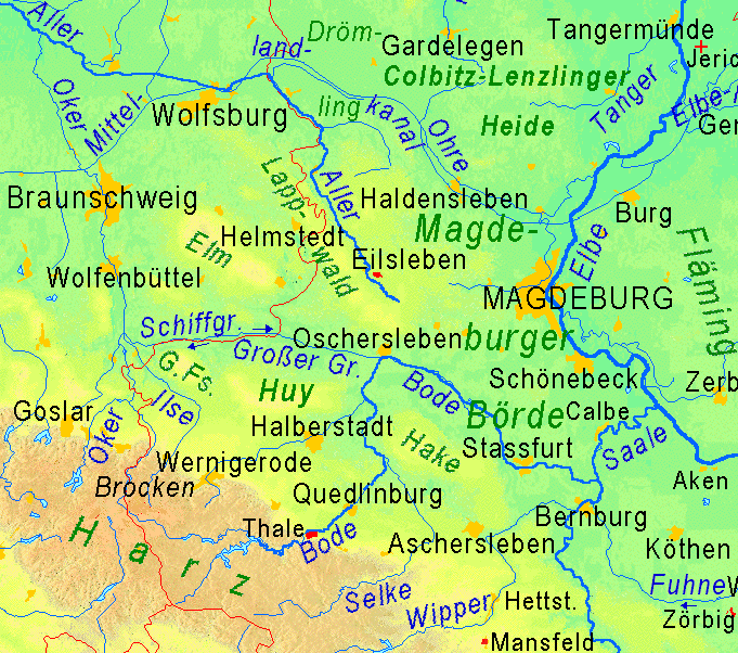
The Magdeburg Börde (german: Magdeburger Börde) is the central landscape unit of the state of Saxony-Anhalt and lies to the west and south of the eponymous state capital Magdeburg. Part of a loess belt stretching along the southeastern rim of the North German Plain, it is noted for its very fertile Chernozem soils. Boundaries The boundaries of the Magdeburg Börde are quite ill-defined. In the west, it borders on the East Brunswick hill country stretching from the Hildesheim Börde in Lower Saxony up to the Hohes Holz forest and the town of Oschersleben on the confluence of the Bode river and the Großer Graben canal. According to the recent editions of the '' Handbook of the Natural Region Divisions of Germany'', the western border north of Oschersleben roughly coincides with the Weser-Elbe watershed along the Druxberge hills. To the northwest, the basin of the Beber river marks the border with the Drömling nature park near Oebisfelde. To the north, the Börde borders o ... [...More Info...] [...Related Items...] OR: [Wikipedia] [Google] [Baidu] |
Niedere Börde
Niedere Börde is a municipality in the Börde district in Saxony-Anhalt, Germany. It is situated between Haldensleben and Magdeburg. It was formed in January 2004 by the merger of the former municipalities Dahlenwarsleben, Groß Ammensleben, Gutenswegen, Jersleben, Klein Ammensleben, Meseberg, Samswegen and Vahldorf. Statistisches Bundesamt
The Federal Statistical Office (german: Statistisches Bundesamt, shortened ''Destatis'') is a federal authority of Germany. It reports to the Federal Ministry of the Interior.
The Office is responsible for coll ...
[...More Info...] [...Related Items...] OR: [Wikipedia] [Google] [Baidu] |
Druxberge
Druxberge is a village and a former municipality in the Börde district in Saxony-Anhalt, Germany. Since 1 September 2010, it is part of the municipality Eilsleben Eilsleben is a municipality in the Börde district in Saxony-Anhalt, Germany. In January 2010 it absorbed the former municipality Wormsdorf and in September 2010 the former municipalities Drackenstedt, Druxberge Druxberge is a village and a .... References Former municipalities in Saxony-Anhalt Börde (district) {{Börde-geo-stub ... [...More Info...] [...Related Items...] OR: [Wikipedia] [Google] [Baidu] |
Selke (river)
The Selke is a river of Saxony-Anhalt, Germany. It is a right-hand tributary of the Bode that starts in the Harz Mountains before breaking out onto the northeastern Harz Foreland. It has a length of , of which lie in the forested mountains of the Harz and the rest on the agricultural lowlands of the Harz Foreland. Course The Selke rises near the village of Friedrichshöhe in the borough of Güntersberge at a height of about above NN. From Friedrichshöhe to Mägdesprung in the borough of Harzgerode, it is accompanied by the Selke Valley Railway for a distance of . The Selke has cut deeply into the Harz Mountains in some places whilst in others it runs in a broad valley, depending on the bedrock. In Meisdorf on the northeastern edge of the Lower Harz, the Selke leaves the forested mountain region and winds across a cultivated plain, continuing to flow in an easterly or northeasterly direction as far as Ermsleben. Beyond Ermsleben the river swings through 90° to the nort ... [...More Info...] [...Related Items...] OR: [Wikipedia] [Google] [Baidu] |
Harz
The Harz () is a highland area in northern Germany. It has the highest elevations for that region, and its rugged terrain extends across parts of Lower Saxony, Saxony-Anhalt, and Thuringia. The name ''Harz'' derives from the Middle High German word ''Hardt'' or ''Hart'' (hill forest). The name ''Hercynia'' derives from a Celtic name and could refer to other mountain forests, but has also been applied to the geology of the Harz. The Brocken is the highest summit in the Harz with an elevation of above sea level. The Wurmberg () is the highest peak located entirely within the state of Lower Saxony. Geography Location and extent The Harz has a length of , stretching from the town of Seesen in the northwest to Eisleben in the east, and a width of . It occupies an area of , and is divided into the Upper Harz (''Oberharz'') in the northwest, which is up to 800 m high, apart from the 1,100 m high Brocken massif, and the Lower Harz (''Unterharz'') in the east which is up to aroun ... [...More Info...] [...Related Items...] OR: [Wikipedia] [Google] [Baidu] |
Mansfeld Land
Mansfeld, sometimes also unofficially Mansfeld-Lutherstadt, is a town in the district of Mansfeld-Südharz, in Saxony-Anhalt, Germany. Protestant reformator Martin Luther grew up in Mansfeld, and in 1993 the town became one of sixteen places in Germany to be designated a ''Lutherstadt'' for this reason. Geography It is situated east of the Harz mountain range on the river Wipper, a left tributary of the Saale, about northwest of Halle. Together with neighbouring Eisleben, it is part of the historic Mansfeld Land region, roughly corresponding to the former district of Mansfelder Land which in 2007 merged into present Mansfeld-Südharz district. Mansfeld station is a stop on the Mansfeldbahn railway line (''Wipperliese''), a branch of the Berlin-Blankenheim railway, running from Klostermansfeld to Wippra. Town districts The township currently comprises 15 districts (''Ortschaften''): [...More Info...] [...Related Items...] OR: [Wikipedia] [Google] [Baidu] |
Saale
The Saale (), also known as the Saxon Saale (german: Sächsische Saale) and Thuringian Saale (german: Thüringische Saale), is a river in Germany and a left-bank tributary of the Elbe. It is not to be confused with the smaller Fränkische Saale, Franconian Saale, a right-bank tributary of the Main (river), Main, or the Saale (Leine), Saale in Lower Saxony, a tributary of the Leine. Etymology The name ''Saale'' comes from the Proto-Indo-European language, Proto-Indo-European root wikt:Reconstruction:Proto-Indo-European/sélos, *''séles'' 'marsh', akin to Welsh language, Welsh ''hêl, heledd'' 'river meadow', Cornish language, Cornish ''heyl'' 'estuary', Ancient Greek, Greek ''hélos'' 'marsh, meadow', Sanskrit ''sáras'' 'lake, pond', Sarasvati River, ''Sárasvati'' 'sacred river', Old Persian ''Harauvati'' 'Harut River, Hārūt River; Arachosia', Avestan ''Haraxvatī'', idem. It may also be related to the Indo-European root *''sal'', "salt". The Slavic name of the Saale, ''Sola ... [...More Info...] [...Related Items...] OR: [Wikipedia] [Google] [Baidu] |
Middle Elbe Biosphere Reserve
The Middle Elbe Biosphere Reserve is a Biosphere Reserve in the German Federal state Saxony-Anhalt. The Middle Elbe reserve is a 430 square kilometre protected reserve, and is the largest protected region in Saxony-Anhal It extends along the Elbe river, between Wittenberg in the east, via Dessau-Roßlau, to Gommern in the northwest. This beautiful region of fluvial topography is one of the main attractions for tourism in Saxony-Anhalt, particularly for bicycle tourism. History The history of the Reserve originates with the Anhalt Environmental Protection Law of 1923. Over the next six years, this initial protected reserve was expanded. The "Saalberge" and "Möster Birken" regions were added in 1926. In 1927, conservation areas for the Elbe beaver and the "Wassernuß" plant (Trapa natans) were added. In 1929, areas between Aken and Tochheim were put under protection. These areas were the predecessors of the Steckby-Lödderitzer Forst conservation area. The Steckby-Lödderitzer Fors ... [...More Info...] [...Related Items...] OR: [Wikipedia] [Google] [Baidu] |
Flechtingen Hills
The Flechtingen Hills (german: Flechtinger Höhenzug) are a wooded, hilly upland area up to 179 m high in the northwestern part of the German state of Saxony-Anhalt, named after the town of Flechtingen. Location The Flechtingen Hills are bordered by the River Aller to the west, the Spetze, a right-hand tributary of the Aller, to the north, the valley of the Ohre to the northeast, through which the Mittelland Canal also runs, and by the Beber, a tributary of the Ohre, to the south. One of the highest elevations in the Flechtingen Hills is the ''Butterberg'' near Ivenrode at . Geology Unlike the surrounding region, geologically old rocks reach the surface of the Flechtingen Hills. It thus forms the northernmost region of bedrock in Germany, because North Germany is almost completely covered by unconsolidated rocks of the Quaternary period. The ridge is mostly composed of volcanic rock and sedimentary rocks of the Carboniferous and Permian periods. In places these are mined i ... [...More Info...] [...Related Items...] OR: [Wikipedia] [Google] [Baidu] |
Mittelland Canal
The Mittelland Canal, also known as the Midland Canal, (german: Mittellandkanal, ) is a major canal in central Germany. It forms an important link in the waterway network of that country, providing the principal east-west inland waterway connection. Its significance goes beyond Germany as it links France, Switzerland and the Benelux countries with Poland, the Czech Republic and the Baltic Sea. At in length,Elwis database WSD Mitte an WSD Ost the Mittelland Canal is the longest artificial waterway in Germany. Route The Mittelland Canal branches off the[...More Info...] [...Related Items...] OR: [Wikipedia] [Google] [Baidu] |
Ohre
The Ohre is a river in northern Germany, left tributary to the Elbe. Its total length is . Its source is north of Wolfsburg, in Lower Saxony. It flows generally south-east, at first following the border of Lower Saxony and Saxony-Anhalt. After Buchhorst it flows completely through Saxony-Anhalt, along the Mittellandkanal. It flows into the Elbe in Rogätz, north of Magdeburg. The towns Brome, Calvörde, Haldensleben and Wolmirstedt lie along the river. The upper course of the Ohre is in the Drömling nature reserve. Between the end of the Second World War and German reunification, the Ohre separated East from West Germany and so formed part of the Inner German border. See also *List of rivers of Lower Saxony *List of rivers of Saxony-Anhalt A list of rivers of Saxony-Anhalt, Germany: A * Aland *Aller * Allerbach, tributary of the Rappbode (Rappbode Auxiliary Dam) * Allerbach, tributary of the Warme Bode * Alte Elbe B * Bauerngraben * Beber *Biese *Black Elster * Bode * Bor ... [...More Info...] [...Related Items...] OR: [Wikipedia] [Google] [Baidu] |
Letzlingen
Letzlingen is a village and a former municipality in the district Altmarkkreis Salzwedel, in Saxony-Anhalt, Germany. Since 1 January 2011, it is part of the town Gardelegen Gardelegen (; nds, Garlä) is a town in Saxony-Anhalt, Germany. It is situated on the right bank of the Milde, 20 m. W. from Stendal, on the main line of railway Berlin-Hanover. History Gardelegen has a Roman Catholic and three Evangelical chur .... References Former municipalities in Saxony-Anhalt Gardelegen {{AltmarkkreisSalzwedel-geo-stub ... [...More Info...] [...Related Items...] OR: [Wikipedia] [Google] [Baidu] |
Altmark
:''See German tanker Altmark for the ship named after Altmark and Stary Targ for the Polish village named Altmark in German.'' The (English: Old MarchHansard, ''The Parliamentary Debates from the Year 1803 to the Present Time ...'', Volume 32. 1 February to 6 March 1816, T.C. Hansard, 1816pp. 82 Article XXIII of the Final Act of the Congress of Vienna) is a historic region in Germany, comprising the northern third of Saxony-Anhalt. As the initial territory of the March of Brandenburg, it is sometimes referred to as the "Cradle of Prussia", as by Otto von Bismarck, a native from Schönhausen near Stendal. Geography The Altmark is located west of the Elbe river between the cities of Hamburg and Magdeburg, mostly included in the districts of Altmarkkreis Salzwedel and Stendal. In the west, the Drawehn hill range and the Drömling depression separate it from the Lüneburg Heath in Lower Saxony; the Altmark also borders the Wendland region in the north and the Magdeburg Börde in th ... [...More Info...] [...Related Items...] OR: [Wikipedia] [Google] [Baidu] |


.jpg)

