|
Mount Tiedemann
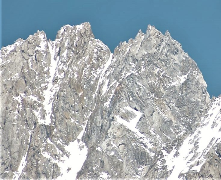
Mount Tiedemann 3838m (12592 feet), prominence 848m, is one of the principal summits of the Pacific Ranges subdivision of the Coast Mountains of British Columbia. It is located northeast of Mount Waddington in the Waddington Range massif between the Homathko River, Homathko and Klinaklini Rivers. Name origin Mount Tiedemann is named for Herman Otto Tiedemann, who worked for the colonial government under Surveyor-General Joseph Despard Pemberton, Joseph Pemberton, designing and supervising construction of Victoria, British Columbia's "Birdcages", the original legislature buildings there, the former courthouse (now the Maritime Museum), the Fisgard Lighthouse and other buildings and churches, all while conducting surveys of the British Columbia and Alaska coast. He was responsible for first bringing water from Elk Lake (British Columbia), Elk Lake to the city as a water supply. In 1862, he had accompanied Alfred Waddington on preliminary surveys for the proposed wagon road to the ... [...More Info...] [...Related Items...] OR: [Wikipedia] [Google] [Baidu] |
Waddington Range
The Waddington Range is a subrange of the Pacific Ranges of the Coast Mountains in southwestern British Columbia, Canada. It is only about 4,000 km2 (1,545 sq mi) in area, relatively small in area within the expanse of the range, but it is the highest area of the Pacific Ranges and of the Coast Mountains, being crowned by its namesake Mount Waddington 4,019 m (13,186 ft). The Waddington Range is also extremely rugged and more a complex of peaks than a single icefield, in contrast to the other huge icefield-massifs of the southern Coast Mountains, which are not so peak-studded and tend to have more contiguous icemasses. History The difficulty of access to the core of the massif delayed actual sighting, measurement and climbing of Mount Waddington until 1936; it had only been espied from Vancouver Island by climbers in the 1930s and was at first referred to as Mystery Mountain - because its existence until then had been unknown. Apparently even in First Nations l ... [...More Info...] [...Related Items...] OR: [Wikipedia] [Google] [Baidu] |
Elk Lake (British Columbia)
Elk Lake is a large lake located in Elk/Beaver Lake Regional Park in Saanich, British Columbia. Elk Lake and Beaver Lake are actually one lake as a shallow channel connects them. Elk/Beaver lake was known as the "Freshwater Playground of Victoria" in its heyday, the 1930s and 1940s. However, with the completion of the Pat Bay highway in the 1950s, focus turned to environmentalism Environmentalism or environmental rights is a broad philosophy, ideology, and social movement regarding concerns for environmental protection and improvement of the health of the environment, particularly as the measure for this health seek ..., and measures were taken to start restoring the park to its natural state and protecting it. In 1966 Elk/Beaver lake became a regional park. References External links Greater Victoria Youth Rowing SocietyYouth School Rowing Club Southern Vancouver Island BC, District #63 [...More Info...] [...Related Items...] OR: [Wikipedia] [Google] [Baidu] |
Landforms Of The Chilcotin
A landform is a natural or anthropogenic land feature on the solid surface of the Earth or other planetary body. Landforms together make up a given terrain, and their arrangement in the landscape is known as topography. Landforms include hills, mountains, canyons, and valleys, as well as shoreline features such as bays, peninsulas, and seas, including submerged features such as mid-ocean ridges, volcanoes, and the great ocean basins. Physical characteristics Landforms are categorized by characteristic physical attributes such as elevation, slope, orientation, stratification, rock exposure and soil type. Gross physical features or landforms include intuitive elements such as berms, mounds, hills, ridges, cliffs, valleys, rivers, peninsulas, volcanoes, and numerous other structural and size-scaled (e.g. ponds vs. lakes, hills vs. mountains) elements including various kinds of inland and oceanic waterbodies and sub-surface features. Mountains, hills, plateaux, and plains are t ... [...More Info...] [...Related Items...] OR: [Wikipedia] [Google] [Baidu] |
Orographic Lift
Orographic lift occurs when an air mass is forced from a low elevation to a higher elevation as it moves over rising terrain. As the air mass gains altitude it quickly cools down adiabatically, which can raise the relative humidity to 100% and create clouds and, under the right conditions, precipitation. Orographic lifting can have a number of effects, including precipitation, rain shadowing, leeward winds, and associated clouds. Precipitation Precipitation induced by orographic lift occurs in many places throughout the world. Examples include: * The Mogollon Rim in central Arizona * The western slope of the Sierra Nevada range in California * The mountains near Baja California North – specifically La Bocana to Laguna Hanson. * The windward slopes of Khasi and Jayantia Hills (see Mawsynram) in the state of Meghalaya in India. * The Western Highlands of Yemen, which receive by far the most rain in Arabia. * The Western Ghats that run along India's western coast. * The Grea ... [...More Info...] [...Related Items...] OR: [Wikipedia] [Google] [Baidu] |
Pacific Ocean
The Pacific Ocean is the largest and deepest of Earth's five oceanic divisions. It extends from the Arctic Ocean in the north to the Southern Ocean (or, depending on definition, to Antarctica) in the south, and is bounded by the continents of Asia and Oceania in the west and the Americas in the east. At in area (as defined with a southern Antarctic border), this largest division of the World Ocean—and, in turn, the hydrosphere—covers about 46% of Earth's water surface and about 32% of its total surface area, larger than Earth's entire land area combined .Pacific Ocean . '' Britannica Concise.'' 2008: Encyclopædia Britannica, Inc. The centers of both the |
Weather Front
A weather front is a boundary separating air masses for which several characteristics differ, such as air density, wind, temperature, and humidity. Disturbed and unstable weather due to these differences often arises along the boundary. For instance, cold fronts can bring bands of thunderstorms and cumulonimbus precipitation or be preceded by squall lines, while warm fronts are usually preceded by stratiform precipitation and fog. In summer, subtler humidity gradients are known as dry lines can trigger severe weather. Some fronts produce no precipitation and little cloudiness, although there is invariably always a wind shift. Cold fronts generally move from west to east, whereas warm fronts move poleward, although any direction is possible. Occluded fronts are a hybrid merge of the two, and stationary fronts are stalled in their motion. Cold fronts and cold occlusions move faster than warm fronts and warm occlusions because the dense air behind them can lift as well as push ... [...More Info...] [...Related Items...] OR: [Wikipedia] [Google] [Baidu] |
Ice Cap Climate
An ice cap climate is a polar climate where no mean monthly temperature exceeds . The climate covers areas in or near the high latitudes (65° latitude) to polar regions (70–90° north and south latitude), such as Antarctica, some of the northernmost islands of Canada and Russia, Greenland, along with some regions and islands of Norway's Svalbard Archipelago that have vast deserts of snow and ice. Areas with ice cap climates are normally covered by a permanent layer of ice and have no vegetation. There is limited animal life in most ice cap climates, usually found near the oceanic margins. Although ice cap climates are inhospitable to human life, there are some small research stations scattered in Antarctica and interior Greenland. Description Under the Köppen climate classification, the ice cap climate is denoted as ''EF''. Ice caps are defined as a climate with no months above . Such areas are found around the north and south pole, and on the top of many high mountains. S ... [...More Info...] [...Related Items...] OR: [Wikipedia] [Google] [Baidu] |
Köppen Climate Classification
The Köppen climate classification is one of the most widely used climate classification systems. It was first published by German-Russian climatologist Wladimir Köppen (1846–1940) in 1884, with several later modifications by Köppen, notably in 1918 and 1936. Later, the climatologist Rudolf Geiger (1894–1981) introduced some changes to the classification system, which is thus sometimes called the Köppen–Geiger climate classification system. The Köppen climate classification divides climates into five main climate groups, with each group being divided based on seasonal precipitation and temperature patterns. The five main groups are ''A'' (tropical), ''B'' (arid), ''C'' (temperate), ''D'' (continental), and ''E'' (polar). Each group and subgroup is represented by a letter. All climates are assigned a main group (the first letter). All climates except for those in the ''E'' group are assigned a seasonal precipitation subgroup (the second letter). For example, ''Af'' indi ... [...More Info...] [...Related Items...] OR: [Wikipedia] [Google] [Baidu] |
Mount Tiedemann
Mount Tiedemann 3838m (12592 feet), prominence 848m, is one of the principal summits of the Pacific Ranges subdivision of the Coast Mountains of British Columbia. It is located northeast of Mount Waddington in the Waddington Range massif between the Homathko River, Homathko and Klinaklini Rivers. Name origin Mount Tiedemann is named for Herman Otto Tiedemann, who worked for the colonial government under Surveyor-General Joseph Despard Pemberton, Joseph Pemberton, designing and supervising construction of Victoria, British Columbia's "Birdcages", the original legislature buildings there, the former courthouse (now the Maritime Museum), the Fisgard Lighthouse and other buildings and churches, all while conducting surveys of the British Columbia and Alaska coast. He was responsible for first bringing water from Elk Lake (British Columbia), Elk Lake to the city as a water supply. In 1862, he had accompanied Alfred Waddington on preliminary surveys for the proposed wagon road to the ... [...More Info...] [...Related Items...] OR: [Wikipedia] [Google] [Baidu] |
Tiedemann Glacier
Tiedemann is both a surname and a given name of German origin, a variant of Thiedemann. Notable people with the name include: Surname: * Carlo von Tiedemann (born 1943), German television presenter * Dietrich Tiedemann (1748–1803), German psychologist * Friedrich Tiedemann (1781–1861), German physiologist * Heinrich von Tiedemann (1840–1922), Prussian politician * Mark W. Tiedemann (born 1954), American science fiction writer * Neil Edward Tiedemann (born 1948), Auxiliary Bishop of Brooklyn and Titular Bishop of Cova * Pyotr Genrikhovich Tiedemann (1872–1941), Russian diplomat * R. G. Tiedemann (1941–2019), German historian * Ricky Tiedemann (born 2002), American baseball player Given name: * Tiedemann Giese (1480–1550), bishop and friend of Copernicus See also * * * Thijmen Thijmen (sometimes translated as ''Thymen'' or ''Tymen''), sometimes written without the 'h', is a masculine given name of Dutch language, Dutch origin. Notable people with the name include: ... [...More Info...] [...Related Items...] OR: [Wikipedia] [Google] [Baidu] |
Chilcotin War
The Chilcotin War, the Chilcotin Uprising or the Bute Inlet Massacre was a confrontation in 1864 between members of the Tsilhqot'in (Chilcotin) people in British Columbia and white road construction workers. Fourteen men employed by Alfred Waddington in the building of a road from Bute Inlet were killed, as well as a number of men with a pack-train near Anahim Lake and a settler at Puntzi Lake. Background In 1862, Alfred Waddington began lobbying the press and his political allies for support to build a wagon road from Bute Inlet to Fort Alexandria, where it would connect to the Cariboo Road and continue on to the goldfields at Barkerville. He received approval for the construction early in 1863. According to Waddington, it would reduce land travel from to and the total days consumed in packing freight from 37 days to 22 compared to the route through Yale and the Fraser Canyon known as the Cariboo Road and favoured by Governor Douglas. The Bute Inlet Wagon Road was to follow t ... [...More Info...] [...Related Items...] OR: [Wikipedia] [Google] [Baidu] |

.jpg)

.jpg)


