|
Mount Banping
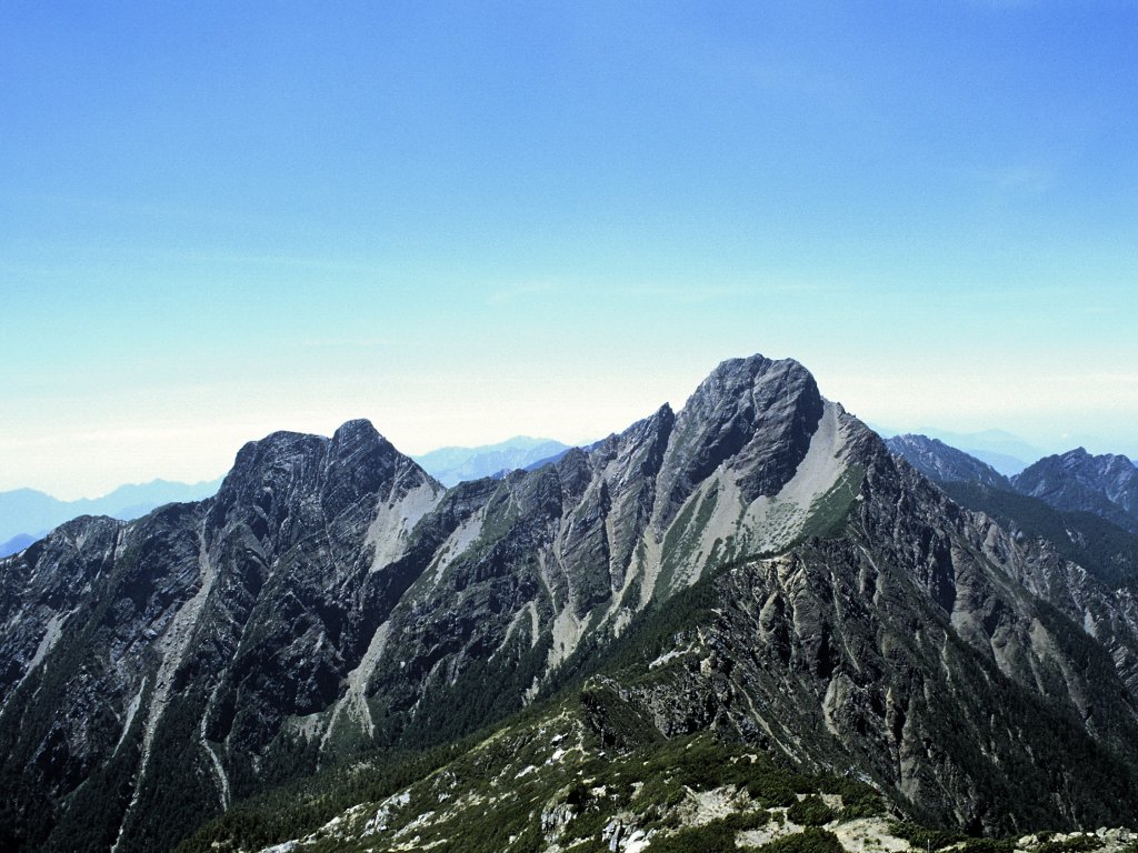
Mount Banping () is a mountain in Nanzih District, Kaohsiung, Taiwan. Name The name ''Banping'' means half screen, named so because of the mountain steep side resembles a painted screen. History During the Qing Dynasty rule of Taiwan, the mountain was the site of the most important limestone quarry in Taiwan. After the quarry was closed in 1997, the mountain was turned into a nature park. Vegetation is used for its slope protection and the old cement plant's grit removal pond was transformed into Banping Lake Wetland Park in the neighboring Zuoying District. Attractions Visitors can hike the mountain via its wooden walkway to enjoy the panoramic views of Kaohsiung from the top of the mountain, which includes Lotus Pond, Zuoying District, Port of Zuoying, Niaosong District and Yancheng District. Transportation The mountain is accessible within walking distance north of Xinzuoying Station. See also * List of tourist attractions in Taiwan * List of mountains in Taiwan ... [...More Info...] [...Related Items...] OR: [Wikipedia] [Google] [Baidu] |
Nanzih District
Nanzih District, United States National Geospatial-Intelligence Agency (also spelled Nanzi; ) is a district located in Kaohsiung City, Taiwan. It was the northernmost district of Kaohsiung City until Kaohsiung County was merged into the municipality in 2010. Nanzih offers convenient access to transportation, including a train and bus station and an interchange on the Sun Yat-sen Freeway. Moreover, it also contains the Nanzih Industrial Zone. Administrative divisions The district consists of Qingfeng, Tungning, Wuchang, Xiangping, Zhongyang, Huinan, Huimin, Huifeng, Jinbing, Yubing, Jintian, Rentian, Ruibing, Cuibing, Hongnan, Hongyi, Hongrong, Guangchang, Jiuchang, Dachang, Fuchang, Chengchang, Taichang, Xingchang, Jianchang, Hongchang, Hechang, Qingchang, Longchang, Xiuchang, Yuchang, Guochang, Jiachang, Renchang, Lantian, Zhongxing and Zhonghe Village.https://www.cec.gov.tw/pc/en/TV/nm64000000400000000.html Education Universities * National Kaohsiung University of Science ... [...More Info...] [...Related Items...] OR: [Wikipedia] [Google] [Baidu] |
Port Of Zuoying
A port is a maritime facility comprising one or more wharves or loading areas, where ships load and discharge cargo and passengers. Although usually situated on a sea coast or estuary, ports can also be found far inland, such as Hamburg, Manchester and Duluth; these access the sea via rivers or canals. Because of their roles as ports of entry for immigrants as well as soldiers in wartime, many port cities have experienced dramatic multi-ethnic and multicultural changes throughout their histories. Ports are extremely important to the global economy; 70% of global merchandise trade by value passes through a port. For this reason, ports are also often densely populated settlements that provide the labor for processing and handling goods and related services for the ports. Today by far the greatest growth in port development is in Asia, the continent with some of the world's largest and busiest ports, such as Singapore and the Chinese ports of Shanghai and Ningbo-Zhou ... [...More Info...] [...Related Items...] OR: [Wikipedia] [Google] [Baidu] |
Landforms Of Kaohsiung
A landform is a natural or anthropogenic land feature on the solid surface of the Earth or other planetary body. Landforms together make up a given terrain, and their arrangement in the landscape is known as topography. Landforms include hills, mountains, canyons, and valleys, as well as shoreline features such as bays, peninsulas, and seas, including submerged features such as mid-ocean ridges, volcanoes, and the great ocean basins. Physical characteristics Landforms are categorized by characteristic physical attributes such as elevation, slope, orientation, stratification, rock exposure and soil type. Gross physical features or landforms include intuitive elements such as berms, mounds, hills, ridges, cliffs, valleys, rivers, peninsulas, volcanoes, and numerous other structural and size-scaled (e.g. ponds vs. lakes, hills vs. mountains) elements including various kinds of inland and oceanic waterbodies and sub-surface features. Mountains, hills, plateaux, and plains ... [...More Info...] [...Related Items...] OR: [Wikipedia] [Google] [Baidu] |
List Of Mountains In Taiwan
The island of Taiwan has the largest number and density of high mountains in the world. This article summarizes the list of mountains that is under the Republic of China's territorial jurisdiction. There are 268 mountain peaks over above sea level on the island, with Yushan (Jade Mountain – in Chinese) being the tallest mountain in both Taiwan and East Asia. Mountaineering is one of the most popular activities for many Taiwanese. A list of 100 Peaks of Taiwan was created in 1971, which lists the selected one hundred mountain peaks over 3,000 m for mountaineering on the island. Climbing all of the one hundred mountain peaks listed is considered a great challenge for Taiwanese climbers. Mountain ranges There are five mountain ranges in the main island of Taiwan List of high mountains Over 3,000 m Notes: *The rank and locations is the one of the highest peak of each mountain. *In total, there are 165 mountains over 3,000 m above sea level, with a total of 275 peaks. *Of ... [...More Info...] [...Related Items...] OR: [Wikipedia] [Google] [Baidu] |
List Of Tourist Attractions In Taiwan
Popular tourist attractions in Taiwan include the following: Attractions Historical buildings * Beihai Tunnel, Beigan () * Beihai Tunnel, Nangan () * Daxi Wude Hall () * Eternal Golden Castle * First Guesthouse * Fongyi Tutorial Academy * Former British Consulate at Takao * Former Japanese Navy Fongshan Communication Center * Former Tainan Weather Observatory * Fort Provintia * Fort Santo Domingo * Fort Zeelandia * Fuxing Barn * Great South Gate * Gulongtou Zhenwei Residence * Hobe Fort * Jhen Wen Academy * Kaohsiung Grand Hotel * Keelung Fort Commander's Official Residence * Lee Teng-fan's Ancient Residence * Lin Family Mansion and Garden * Meinong East Gate Tower * Moving Castle * Niumatou Site * North Gate of Xiong Town * Presidential Office Building * Qihou Fort * Qing Dynasty Taiwan Provincial Administration Hall * Shihlin Paper Mill * Taipei Guest House * Tianma Tea House * Walls of Taipei * Wist ... [...More Info...] [...Related Items...] OR: [Wikipedia] [Google] [Baidu] |
Xinzuoying Station
Zuoying () is a metro and railway station in Kaohsiung, Taiwan served by Kaohsiung MRT, Taiwan High Speed Rail, and Taiwan Railways, where it is known as Xinzuoying (). The station is served by the fastest HSR express services of the ''1 series''. Overview The station is located at the eastern foot of Mt. Panping (also known as Mt. Banping) in Kaohsiung, next to the South East Cement factory buildings. In addition to rail routes, the station is also close to National Highway No. 1, 3, 10 and Provincial Highway No. 1 and 17. On 15 October 2009, Shin Kong Mitsukoshi won a deal to lease a building at the station and turn it into a shopping complex under a 10-year operate-transfer (OT) contract for NT$505 million (US$15.6 million). The new branch opened at the north-east corner of station on 1 April 2010. In June 2009, a folding bike rental station was set up at the MRT station to facilitate tourism in the city. The station is also equipped with vehicle and motorcycle ... [...More Info...] [...Related Items...] OR: [Wikipedia] [Google] [Baidu] |
Yancheng District, Kaohsiung
Yancheng District () is a District (Taiwan), district in Kaohsiung City, Taiwan. It is the smallest district in Kaohsiung City. It has been the least populous district of Kaohsiung since 2004. Yancheng District is also an old town of Kaohsiung. Geography * Area: * Population: 22,531 (May 2022) Administrative divisions The district consists of Lanqiao, Ciai, Boai, Shouxing, Zhongshan, Jiaoren, Xinle, Zhongyuan, Guangming, Yuren, Hebin, Shade, Nanduan, Gangdou, Jiangxi, Xinfeng, Fubei, Liuqiao, Lainan, Xinhua and Jiangnan Village.https://www.cec.gov.tw/pc/en/TV/nm64000000100000000.html Government The representative for Yancheng on the city council is Lee Chiao-Ju. Tourist attractions * International Convention Center Kaohsiung * Kaohsiung City Music Hall * Kaohsiung Film Archive * Kaohsiung Museum of History * Kaohsiung Music Center * Love Pier * Love River * Pier-2 Art Center ** Hamasen Museum of Taiwan Railway *Yanchengpu Night Market Transportation The district is accessib ... [...More Info...] [...Related Items...] OR: [Wikipedia] [Google] [Baidu] |
Niaosong District
Niaosong District () is a rural district of Kaohsiung City, Taiwan. History After the handover of Taiwan from Japan to the Republic of China in 1945, Niaosong was organized as a rural township of Kaohsiung County. On 25 December 2010, Kaohsiung County was merged with Kaohsiung City and Niaosong was upgraded to a district of the city. Geography It has 43,937 inhabitants in 2016. Administrative divisions The district consists of Diaosong, Mengli, Dahua, Dipu, Renmei, Dazhu and Huamei Village.https://www.cec.gov.tw/pc/en/TV/nm64000001800000000.html Government institutions * Radiation Monitoring Center Education * Cheng Shiu University Tourist attractions * Chengcing Lake * Chengcing Lake Baseball Stadium * Dharma Drum Mountain Zi Yun Temple (法鼓山紫云寺) * Kaohsiung Grand Hotel * Niaosong Wetland Park Notable natives * Huang Shihui, writer See also * District (Taiwan) Districts are administrative subdivisions of the Taiwan, Republic of China (Taiwan)'s special ... [...More Info...] [...Related Items...] OR: [Wikipedia] [Google] [Baidu] |
Lotus Pond, Kaohsiung
Lotus Pond () is an artificial lake and popular tourist destination on the east side of Zuoying District in Kaohsiung, Taiwan. Opened in 1951, it is famous for the lotus plants on the lake and the numerous temples around the lake, including the Spring and Autumn Pavilions (春秋閣), the Dragon and Tiger Pagodas (龍虎塔), and the Confucian Temple (孔廟). Lotus Pond was the site for several water sporting events for World Games 2009, including canoe polo, water ski, and dragon boat. Temples Kaohsiung Confucius Temple The old Confucius Temple was originally built in 1684. The temple has a circumference of to 122 meters. However, during the Japanese colonial period due to lack of maintenance, the only part of the original structure was the Chong Sheng Shrine, which is presently which located in the west side of Old City Elementary School nearby Lotus Pond. The new Confucius Temple was located in northwest corner of Lotus Pond; then, it was relocated and rebuilt in 1977, loc ... [...More Info...] [...Related Items...] OR: [Wikipedia] [Google] [Baidu] |
Kaohsiung
Kaohsiung City (Mandarin Chinese: ; Wade–Giles: ''Kao¹-hsiung²;'' Pinyin: ''Gāoxióng'') is a special municipality located in southern Taiwan. It ranges from the coastal urban center to the rural Yushan Range with an area of . Kaohsiung City has a population of approximately 2.72 million people as of May 2022 and is Taiwan's third most populous city and largest city in southern Taiwan. Since founding in the 17th century, Kaohsiung has grown from a small trading village into the political and economic centre of southern Taiwan, with key industries such as manufacturing, steel-making, oil refining, freight transport and shipbuilding. It is classified as a "Gamma −" level global city by the Globalization and World Cities Research Network, with some of the most prominent infrastructures in Taiwan. The Port of Kaohsiung is the largest and busiest harbor in Taiwan while Kaohsiung International Airport is the second busiest airport in number of passengers. The city is ... [...More Info...] [...Related Items...] OR: [Wikipedia] [Google] [Baidu] |
Banping Lake Wetland Park
The Banping Lake Wetland Park () is a constructed wetland in Zuoying District, Kaohsiung, Taiwan. History The area around the park used to be a geological limestone mountain called Mount Banping. It used to be an important source of Taiwan's limestone ore needs. In 1997, the mining activities ceased to operate after 30 years of activity and the mining area began to recover to its original condition. Several years later, the Kaohsiung City Government carried out a conservation plan to protect the soil and water for the abandoned mine area. After years of restorative afforestation and rehabilitation, the mountain slowly regained its original beauty. In 2004, the Kaohsiung Association of Hydraulic Engineers was commissioned by Kaohsiung City Government to execute an evaluation of the possibility of using the Chien Tai Cement Company's grit chamber area at the southern side of Banping Mountain for a wetland park. The result of the evaluation was positive and that in 2005 the City ... [...More Info...] [...Related Items...] OR: [Wikipedia] [Google] [Baidu] |


.jpg)


