|
Motordrome, California
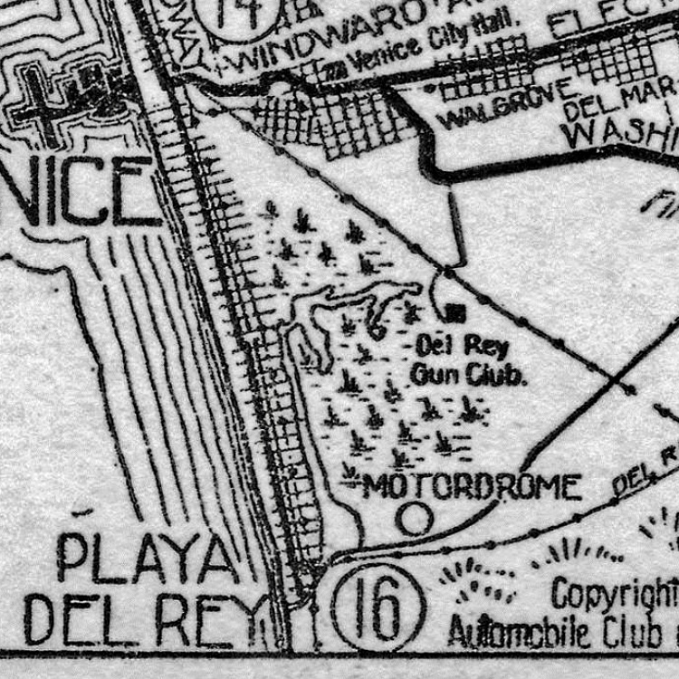
Motordrome is an archaic placename in Los Angeles County, California. It designates a rail spur that existed in the 1910s on the Redondo Beach via Del Rey Line, named for the Los Angeles Motordrome race track and airfield. Even though the racetrack was destroyed in a fire in 1913, and the rails were removed by 1918, the place name persisted on USGS survey maps until at least the 1930s. The Barnes Circus train partially derailed at Motordrome in 1914, injuring four. Motordrome station lay at an elevation of 7 feet (2 m). The coordinates for Motordrome preserved in the GNIS () place it near the present-day intersections of Jefferson Boulevard and Culver Boulevard, in what is now the Ballona Wetlands Ecological Reserve. See also * Alla, California * Alsace, California * Cypress Grove, California * Machado, California Machado refers to three locations in Los Angeles, California, all named for the rancho-era Machado family. Machado is a name derived from Portuguese mea ... [...More Info...] [...Related Items...] OR: [Wikipedia] [Google] [Baidu] |
Motordrome 1914
Motordrome may refer to: *Board track racing venues *Wall of death * ''Motordrome'' (album), a 2022 album by MØ Places in Australia *Motordrome (Melbourne), a former sports venue Places in the United States *Motordrome, California Motordrome is an archaic placename in Los Angeles County, California. It designates a rail spur that existed in the 1910s on the Redondo Beach via Del Rey Line, named for the Los Angeles Motordrome race track and airfield. Even though the race ..., a former streetcar stop and archaic placename in Los Angeles County * Newark Motordrome in Newark, New Jersey * Brighton Beach Motordrome in Brighton Beach, New York {{Disambiguation ... [...More Info...] [...Related Items...] OR: [Wikipedia] [Google] [Baidu] |
Ballona Wetlands Ecological Reserve
Ballona Wetlands Ecological Reserve (pronunciation: "Bah-yo-nuh" or "Buy-yo-nah" ) is a protected area that once served as the natural estuary for neighboring Ballona Creek. The site is located in Los Angeles County, California, just south of Marina del Rey. Ballona—the second-largest open space within the city limits of Los Angeles, behind Griffith Park—is owned by the state of California and managed by the California Department of Fish and Wildlife. The preserve is bisected generally east-west by the Ballona Creek channel and bordered by the 90 Marina freeway to the east. Ballona Wetlands Ecological Reserve is one of the last significant wetlands or marshes left in Los Angeles County, wetlands being "areas that are periodically, seasonally or perennially flooded that also have specific types of vegetation." Ballona is a "fragile, self-sustaining bog, fed by both fresh and salt water…This and other major wetlands of the Los Angeles Basin, including Bixby Slough…have b ... [...More Info...] [...Related Items...] OR: [Wikipedia] [Google] [Baidu] |
Machado, California
Machado refers to three locations in Los Angeles, California, all named for the rancho-era Machado family. Machado is a name derived from Portuguese meaning "hatchet", the stop was probably more directly named for the Machado family of the Rancho era. The family, however, may have used a hatchet to mark their lands. An 1855 real estate description mentions a "cottonwood tree marked with cuts of a hatchet." (1) Machado is a former rail stop in Los Angeles County, California. It laid at an elevation of 13 feet (4 m). Machado was a stop on the Venice–Inglewood Line just north of Alla Junction; the line, which dated to the late 19th century, was lightly used for both passengers and freight. Machado still appeared on USGS maps as of 1934. (2) Machado post office was organized circa 1878 an application was made to the Post Office Department. The new Machado post office station was located northwest quarter section 12 township 2W range 15 west, half a mile north of Ballona Creek ... [...More Info...] [...Related Items...] OR: [Wikipedia] [Google] [Baidu] |
Cypress Grove, California
Cypress Grove, California was a stop on the Redondo Beach via Playa Del Rey Line of the Los Angeles streetcar system. The Cypress Grove stop was located just east of Alla Junction in what is now the Del Rey neighborhood of Los Angeles in Los Angeles County, California. Based on the coordinates () in the Geographic Names Information System, the stop was at what is now the intersection of Centinela Avenue and Culver Boulevard. The planned Venice Del Rey development near the Cypress Grove stop of the Playa Del Rey Line was platted in 1905, and several streets were constructed and named after composers (Beethoven, Verdi, Wagner, Mascagni, et al.), but the residences were never built. See also * Alla, California * Alsace, California * Motordrome, California * Machado, California Machado refers to three locations in Los Angeles, California, all named for the rancho-era Machado family. Machado is a name derived from Portuguese meaning "hatchet", the stop was probably more dire ... [...More Info...] [...Related Items...] OR: [Wikipedia] [Google] [Baidu] |
Alsace, California
Alsace is an archaic place name. Originally an interurban trolley stop, the name now informally designates an approximately five-block area of unincorporated Los Angeles County in the Westside region, surrounded by the north-of-Jefferson section of Playa Vista, Los Angeles, California. Geography The Alsace area is one of approximately 472 recognized neighborhoods in Los Angeles County. Although historically Alsace was a large, amorphously defined section of Los Angeles lying between Ballona Creek and what is now Jefferson Boulevard, today Alsace consists of a five-block strip of unincorporated Los Angeles County land bounded Jefferson Boulevard, Centinela Avenue, Grosvenor Boulevard, and Centinela Creek Channel (or Marina Freeway, California State Route 90, which runs parallel to the creek channel in this section). The streets of Alsace include one-block sections of Hammack Street, Aneta Street, Lucile Street, Beatrice Street, as well as a very short span of Juniette S ... [...More Info...] [...Related Items...] OR: [Wikipedia] [Google] [Baidu] |
Alla, California
Alla is a former streetcar station and archaic place name located near Marina del Rey in the Westside region of Los Angeles County, California. The former Glen Alla Park (now Bill Rosendahl Del Rey Park) is also derivative of this place name; the park sits near the intersection of Glencoe and Alla. Alla lies at an elevation of 16 feet (5 m). History Alla is named after a turn-of-the-last century hunting lodge, Alla Gun Club, which organized duck hunts at what is now Ballona Wetland Ecological Reserve. The Alla station of the Pacific Electric route was named after the club’s old hunting grounds. In 1902, Alla Station was described as being “two miles distant” from the new Playa Del Rey development; the coordinates of the station recorded in the GNIS () place it on the north side of Culver Boulevard near what is now the Marina Freeway. Alla Station was the site of a wye where the Inglewood Line and Redondo via Del Rey Lines of the Los Angeles electric streetcar sys ... [...More Info...] [...Related Items...] OR: [Wikipedia] [Google] [Baidu] |
Location Of Motordrome Stop (California Geographic Place Name)
In geography, location or place are used to denote a region (point, line, or area) on Earth's surface or elsewhere. The term ''location'' generally implies a higher degree of certainty than ''place'', the latter often indicating an entity with an ambiguous boundary, relying more on human or social attributes of place identity and sense of place than on geometry. Types Locality A locality, settlement, or populated place is likely to have a well-defined name but a boundary that is not well defined varies by context. London, for instance, has a legal boundary, but this is unlikely to completely match with general usage. An area within a town, such as Covent Garden in London, also almost always has some ambiguity as to its extent. In geography, location is considered to be more precise than "place". Relative location A relative location, or situation, is described as a displacement from another site. An example is "3 miles northwest of Seattle". Absolute location An absolute locati ... [...More Info...] [...Related Items...] OR: [Wikipedia] [Google] [Baidu] |
Motordrome Photo In The Bystander Magazine
Motordrome may refer to: *Board track racing venues *Wall of death * ''Motordrome'' (album), a 2022 album by MØ Places in Australia *Motordrome (Melbourne), a former sports venue Places in the United States *Motordrome, California Motordrome is an archaic placename in Los Angeles County, California. It designates a rail spur that existed in the 1910s on the Redondo Beach via Del Rey Line, named for the Los Angeles Motordrome race track and airfield. Even though the race ..., a former streetcar stop and archaic placename in Los Angeles County * Newark Motordrome in Newark, New Jersey * Brighton Beach Motordrome in Brighton Beach, New York {{Disambiguation ... [...More Info...] [...Related Items...] OR: [Wikipedia] [Google] [Baidu] |
Jefferson Boulevard
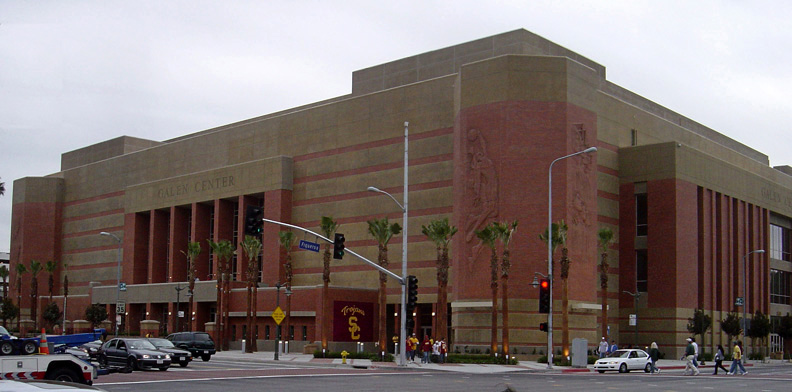
Jefferson Boulevard is a street in Los Angeles and Culver City, California. Its eastern terminus is at Central Avenue east of Exposition Park. At its entrance to Culver City, it splits with National Boulevard. North of Sawtelle Boulevard, it merges with Sepulveda Boulevard. Jefferson returns before Slauson Avenue and ends at Culver Boulevard; its western terminus is near Playa Del Rey. Education and transportation University of Southern California (USC) is located on Jefferson Boulevard from Figueroa Street to Vermont Avenue. Its sports center complex, the Galen Center, is located at the southeast corner of Jefferson and Figueroa. Bus service is operated through Jefferson Boulevard between Playa Vista and West L.A. Transit Center by Culver City Transit line 4, between West LA Transit Center and USC by Metro Local line 38, and east of USC by Metro Local line 102. The Metro E Line serves two light rail stations at Jefferson: one at Flower Street near USC and the other on ... [...More Info...] [...Related Items...] OR: [Wikipedia] [Google] [Baidu] |
Los Angeles County, California
Los Angeles County, officially the County of Los Angeles, and sometimes abbreviated as L.A. County, is the List of the most populous counties in the United States, most populous county in the United States and in the U.S. state of California, with 9,861,224 residents estimated as of 2022. It is the most populous non–State (United States), state-level government entity in the United States. Its population is greater than that of 40 individual List of U.S. states and territories by population, U.S. states. At and with List of cities in Los Angeles County, California, 88 incorporated cities and List of unincorporated communities in Los Angeles County, California, many unincorporated areas, it is home to more than one-quarter of California residents and is one of the most ethnically diverse counties in the United States. Its county seat, Los Angeles, is also California's most populous city and the second-most populous city in the United States, with about 3.9 million residents. I ... [...More Info...] [...Related Items...] OR: [Wikipedia] [Google] [Baidu] |
GNIS
The Geographic Names Information System (GNIS) is a database of name and locative information about more than two million physical and cultural features throughout the United States and its territories, Antarctica, and the associated states of the Marshall Islands, Federated States of Micronesia, and Palau. It is a type of gazetteer. It was developed by the United States Geological Survey (USGS) in cooperation with the United States Board on Geographic Names (BGN) to promote the standardization of feature names. Data were collected in two phases. Although a third phase was considered, which would have handled name changes where local usages differed from maps, it was never begun. The database is part of a system that includes topographic map names and bibliographic references. The names of books and historic maps that confirm the feature or place name are cited. Variant names, alternatives to official federal names for a feature, are also recorded. Each feature receives a per ... [...More Info...] [...Related Items...] OR: [Wikipedia] [Google] [Baidu] |
Barnes Circus
Al G. Barnes Circus was an American circus run by Alpheus George Barnes Stonehouse that operated from 1898 to 1938. History Stonehouse started his show in 1895 with a pony, a phonograph, and a stereopticon. By 1929, the "Al G. Barnes Wild Animal Show" had grown to five rings and it was purchased by the American Circus Corporation. American Circus already owned the Sells-Floto Circus, John Robinson Shows, Hagenbeck-Wallace Circus, and Sparks Circus. That same year John Ringling, the owner of the Ringling Bros. and Barnum & Bailey Circus, bought out the American Circus Corporation. The five circuses that were part of that acquisition continued to tour under their own names, but were closed one-by-one during the Great Depression. In 1937, the Al G. Barnes Wild Animal Show and Sells Floto were combined into one circus. That circus, Al G. Barnes Sells-Floto toured in 1937 and 1938. In 1938, the co-owned Ringling Bros and Barnum & Bailey Combined Shows was experiencing labor pr ... [...More Info...] [...Related Items...] OR: [Wikipedia] [Google] [Baidu] |


